Monuments in Spain
A guide to 4655 Monuments in Spain — with descriptions, photos and traveler visits from the NextOnTrip community. Locations spread across 2240 cities and towns. Most visited by the community: castle of Chulilla, Castle of Pioz, castell de la Todolella.
-
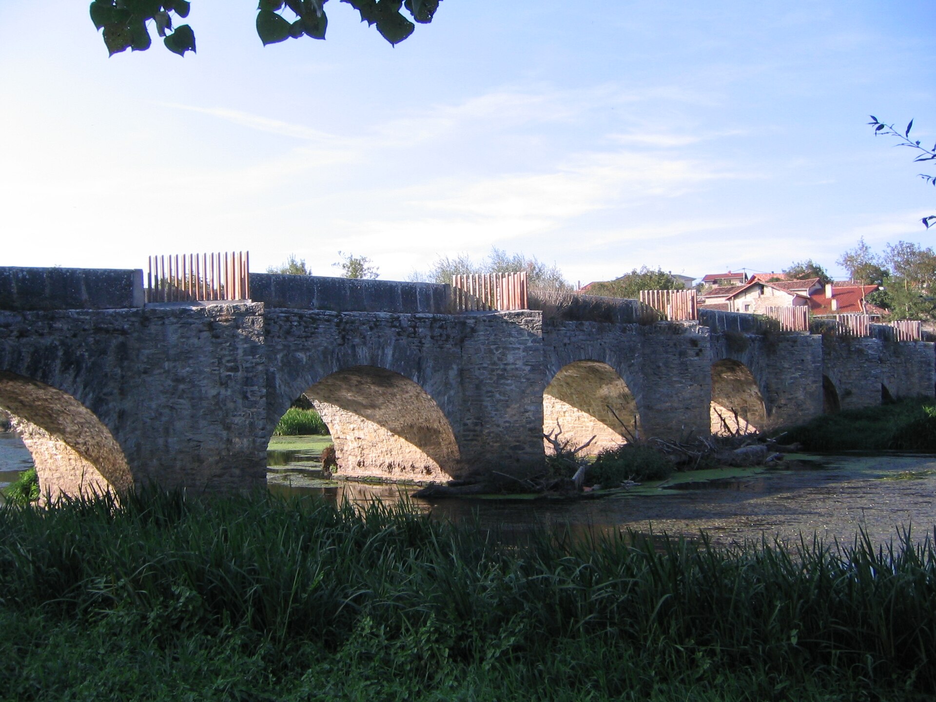
Bridge of Trespuentes
Iruña Oka / Iruña de Oca
The Bridge of Trespuentes is a long stone bridge spanning the Zadorra River in the municipality of Iruña Oka / Iruña de Oca, in Álava, in Spain's Basque Country. It ranks among the most recognizable structures in the area and is a natural stop for anyone visiting the nearby Roman site of Iruña-Veleia. Where does the name Trespuentes come from? The village of Trespuentes has appeared in documents since at least the 11th century, and its name comes from the Latin "transpontem" — literally "behind the bridge." The term described a settlement lying on the far side of the river as seen from the ancient city of Iruña-Veleia. The hamlet itself is thought to have grown up as an outlying district beyond the walls of that Roman city, on the opposite bank of the crossing. Does the bridge really date back to Roman times? Because of its proximity to Iruña-Veleia, one of the most important Roman cities in what is now Álava, the bridge has long carried a reputation for Roman origins. No study has ever confirmed this conclusively, but the location itself — a crossing that gave its name to a settlement defined by "being behind the bridge" relative to a Roman town — has kept that tradition alive for centuries. How was the bridge built? What visitors see today is the result of several building phases layered on top of one another. The structure has thirteen semicircular arches resting on twelve piers, and the piers themselves clearly belong to different periods of construction. The first six arches form the oldest section, the next five were added later, and the final two belong to a later phase marked by an unusually thick, heavy pier. Builders used slate slabs bound with mortar for most of the structure, while the stones forming the arches themselves were laid dry, without mortar — a technique typical of older bridge-building in the region. The bridge's current overall form reflects more modern standards and may only date from after the 16th century, even though older sections point to a much longer history at this crossing. Why is it worth a visit? The Bridge of Trespuentes is more than a piece of engineering history — it also offers a quiet vantage point over the Zadorra valley and the farmland surrounding it. Basque heritage authorities have protected the bridge as a site of cultural interest, underlining its importance to the region's history. For travelers already exploring Iruña-Veleia, the bridge is a natural extension of the visit: it helps explain how settlement patterns developed around the old Roman city over the centuries, with the river marking the boundary between successive communities. Frequently Asked Questions Where exactly is the Bridge of Trespuentes located? It crosses the Zadorra River at Trespuentes, a village within the municipality of Iruña Oka / Iruña de Oca in the province of Álava, right next to the Iruña-Veleia archaeological site. Is the bridge actually Roman? Tradition links it to the Roman period because of its closeness to Iruña-Veleia and the Latin origin of the village's name, but no study has definitively proven that the visible structure is Roman — most of what stands today dates from later building phases. How many arches does the bridge have? Thirteen semicircular arches supported by twelve piers, built up over several distinct construction periods. Can it be visited together with Iruña-Veleia? Yes, the two sites sit close to each other and combine naturally into a single outing focused on the Roman and medieval history of this part of Álava.
-
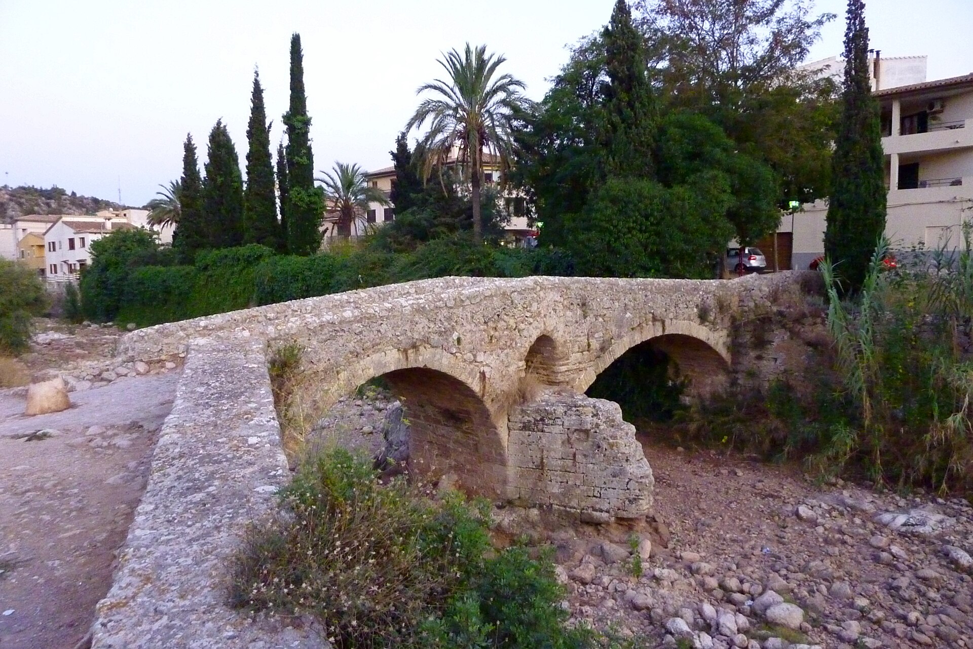
Pont Romà
Pollença
Pont Romà is a historic stone bridge in Pollença, Mallorca, spanning the Torrent de Sant Jordi stream right at the edge of the town's historic centre. It's not a fenced-off monument you visit on a separate detour — the bridge sits along the street that bears its name, Carrer del Pont Romà, and remains woven into everyday town life. Is the Roman Bridge actually Roman? This is the question almost everyone asks, and the answer is less straightforward than the name suggests. The bridge only came to be called "Pont Romà" (Roman Bridge) in the 19th century, when locals noted how closely its arches resembled ancient Roman viaducts. Historians remain divided on its true age. One theory points to Roman construction, likely in the 1st century AD. A second theory, backed by more recent architectural analysis, places its construction in medieval times, around the 13th century — after King Jaume I of Aragon conquered Mallorca in 1229, a period when new routes were being built across the island to connect the interior with the port of Alcúdia. The bridge's semicircular arches fit the late-Romanesque building style typical of that era. How is the bridge built? The structure rests on two unequal arches separated by a central pillar. That pillar includes a small relief arch designed to ease the pressure of floodwater during sudden surges in the stream. At the base, two triangular buttresses were built to break the force of the current and protect the structure from erosion. This kind of engineering, common on bridges crossing seasonal Mediterranean streams prone to flash floods, has kept the crossing standing for centuries. Why did this bridge matter so much to Pollença? Until the 19th century, Pont Romà was the only safe crossing point over the Torrent de Sant Jordi during the flash floods and heavy autumn rains typical of Mallorca. For residents and travellers alike, the bridge wasn't simply a piece of scenery — it was a practical necessity, since crossing the swollen stream without it could be genuinely dangerous. What else should visitors know about the area? The bridge sits directly on the GR 221 long-distance trail, better known as the Ruta de Pedra en Sec (Dry Stone Route), one of Mallorca's best-known hiking paths, which runs the length of the Serra de Tramuntana mountains. Right next to the bridge stands the Refugi Pont Romà, a hikers' shelter housed in what used to be the town's municipal slaughterhouse, now serving as a rest stop for walkers on the trail. It's a natural place to pause before continuing on to the centre of Pollença, just a short walk away. Pont Romà makes an easy addition to a walk through Pollença — no detour required — and offers a tangible piece of the town's history in a form that still does exactly what it was built for: letting people cross the stream. Frequently Asked Questions Is Pont Romà really from Roman times? There's no conclusive evidence either way. The name dates from the 19th century, inspired by the bridge's resemblance to Roman viaducts, but most researchers now favour a medieval origin, around the 13th century. Where exactly is the bridge located? It stands within the town of Pollença, crossing the Torrent de Sant Jordi stream, on Carrer del Pont Romà. Can hikers stop there along a trail? Yes — the Refugi Pont Romà shelter sits right beside the bridge and forms part of the GR 221 Ruta de Pedra en Sec trail. What does the bridge's structure look like? It has two unequal arches resting on a central pillar with a small relief arch, plus two triangular buttresses at the base that protect it from the force of the water.
-
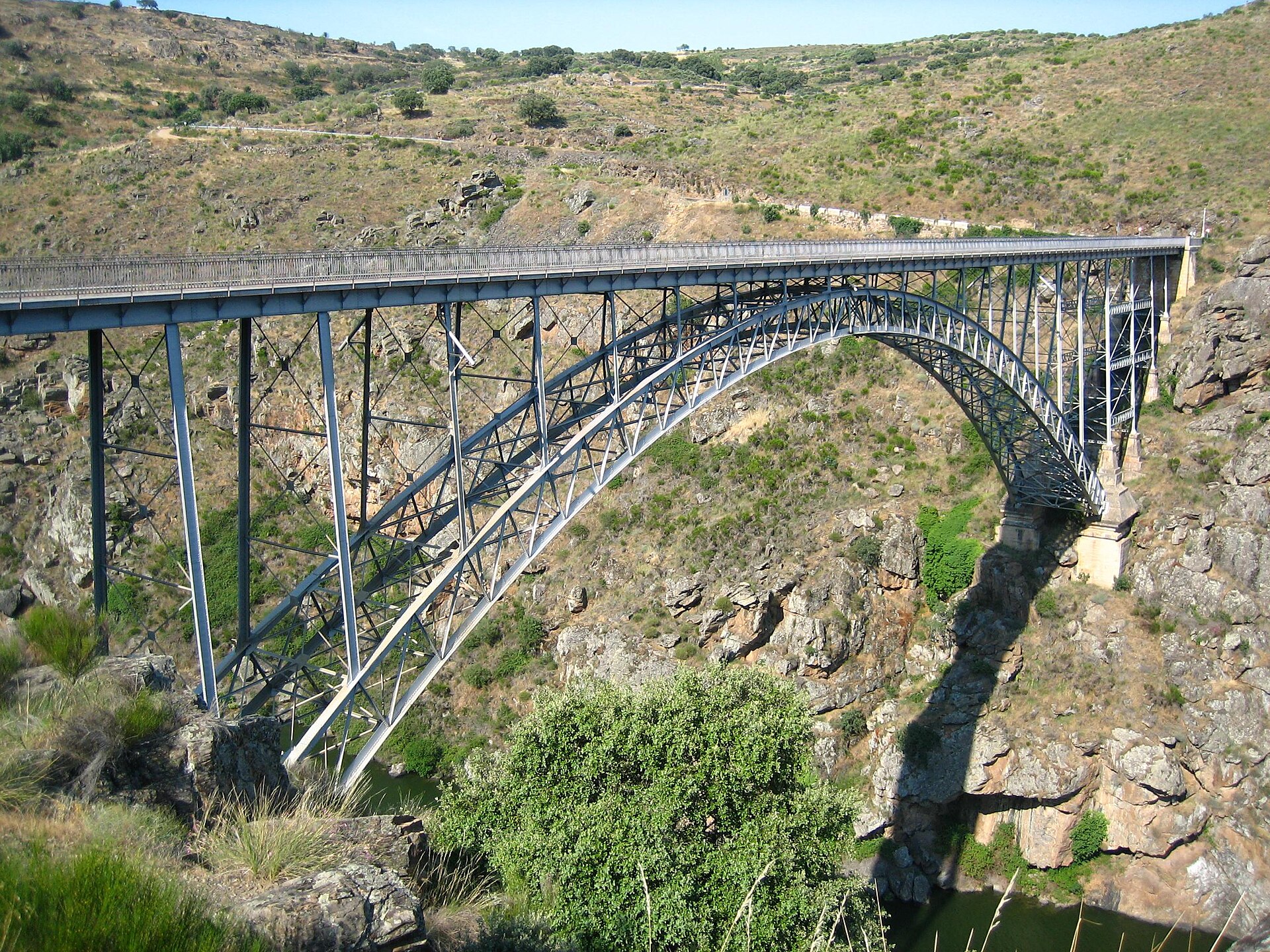
Requejo Bridge
Pino del Oro
Requejo Bridge is a steel bridge spanning the Duero River between the municipalities of Pino del Oro and Villadepera, in the province of Zamora, Castile and León. Also known locally as Puente Pino, it has stood for over a century as one of the most striking pieces of engineering in the Arribes del Duero region. Where exactly is the bridge located? The structure crosses a deep canyon carved by the Duero River, right where the river forms the natural boundary between the Sayago and Aliste districts. The surrounding area belongs to Arribes del Duero, a stretch of rugged, steep-walled gorges along the Spanish-Portuguese border prized for its wild scenery and dramatic drops toward the water. The bridge is one of the recognizable landmarks for visitors exploring this stretch of the canyon. Why was the bridge built in the first place? Before the crossing existed, the only way to get across the Duero between Pino del Oro and Villadepera was a passenger barge that ferried people between the two banks. That arrangement made travel and trade between the two districts slow and weather-dependent. A permanent bridge promised a direct road link where journeys had previously relied on the availability of the ferryman and the state of the river. Who designed and built Requejo Bridge? The project was driven by Federico Requejo Avedillo, then director general of public works, whose name the bridge still carries. The design itself was drawn up in 1897 by engineer José Eugenio Ribera, one of the leading figures in Spanish bridge engineering at the turn of the twentieth century. The actual construction, complicated by the canyon's steep, rocky terrain, was carried out by the Asturian company Duro Felguera, which also employed local workers on site. The bridge was formally inaugurated on 15 September 1914, in a ceremony presided over by Abilio Calderón, the director general of public works at the time. What made this bridge stand out? When it was completed, Requejo Bridge held two national records: the longest span (120 meters) and the greatest height above a river (90 meters) of any bridge in Spain. It was precisely the scale of the engineering challenge — the steep, rocky canyon walls and the considerable height above the water — that made its construction one of the more talked-about technical feats of the era in this part of the country. Who should plan to visit? The bridge appeals both to people interested in engineering history and to those drawn to the Arribes del Duero landscape. It makes a good stop for landscape photography, scenic walks, and routes linking the Sayago and Aliste districts, both known for their stone rural architecture and quiet, low-key style of tourism. The nearby village of Pino del Oro serves as a convenient base for exploring the surrounding area. Frequently Asked Questions Is Requejo Bridge known by any other name? Yes, it is also commonly called Puente Pino in the region. When was the bridge officially opened? It was inaugurated on 15 September 1914. Which two municipalities does the bridge connect? It links Pino del Oro and Villadepera, on opposite sides of the Duero canyon in Zamora province. What made the bridge exceptional at the time it was built? In 1914 it had the longest span and the greatest height above a river of any bridge in Spain.
-
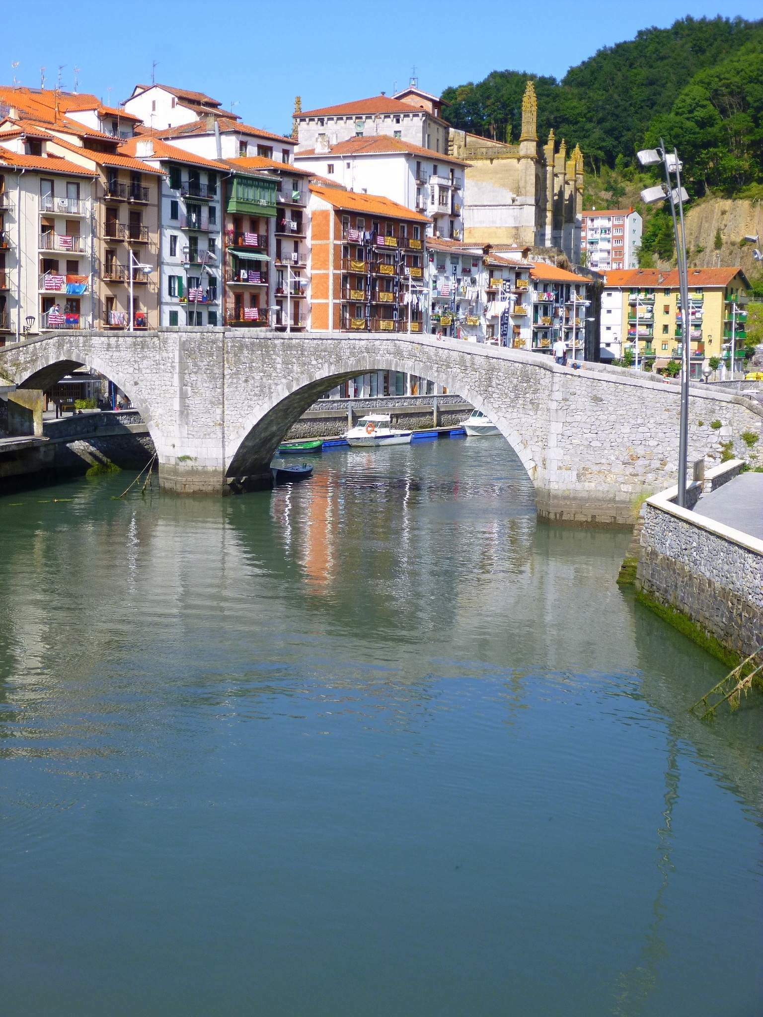
Zubi Zaharra, Ondarroa
Ondarroa
Zubi Zaharra is the old stone bridge in Ondarroa, one of the most distinctive landmarks in this fishing town on the Biscay coast of the Basque Country. The name means simply "old bridge" in Basque, and the crossing links the two banks of the Artibai river right where it meets the Cantabrian Sea, in the heart of the old town. Where does the bridge come from? A crossing has stood on this spot since at least the 14th century. In 1330 a wooden drawbridge occupied the site, a common solution in port towns of the period, since it could be raised to let boats pass upriver. The stone bridge visitors see today dates from much later, 1795, and it's this masonry structure that has survived to the present, though in a heavily altered state. The bridge has had a rough history. In 1936, during the Spanish Civil War, it suffered serious damage, and in 1953 a major flood came close to destroying it entirely. Because of these events, today's Zubi Zaharra looks quite different from the original 18th-century structure — repeated repairs and rebuilding over the decades mean the bridge's original form is hard to make out now. What else is around the bridge? Zubi Zaharra sits in the oldest part of Ondarroa, in the area where the town first grew up around its fishing port. Right next to the bridge stands the building of the former Cofradía de Pescadores, the Fishermen's Brotherhood, an institution closely tied to Ondarroa's identity as one of Biscay's important fishing ports. That proximity says a lot about how the bridge and the town's port life have been intertwined for centuries. Walking through Ondarroa's old quarter, with Zubi Zaharra and the mouth of the Artibai in view, is a natural starting point for exploring the rest of the town — its colorful fishermen's houses, the working harbor front, and the narrow streets of the old town climbing up the hillside. Why visit? Ondarroa is one of those Basque towns that still runs on fishing rather than tourism, and the Zubi Zaharra bridge is part of that genuine, working-port atmosphere. It's a stop for travelers looking for something beyond San Sebastián and Bilbao — a piece of history built into the daily life of a small fishing town, where an old bridge still spans the same two riverbanks its wooden predecessor connected nearly seven centuries ago. Frequently Asked Questions What does Zubi Zaharra mean? It's Basque for "old bridge," a name that refers directly to the age and function of this crossing over the Artibai river. When was the current bridge built? The stone bridge standing today was built in 1795, replacing an earlier wooden drawbridge that had stood on the site since 1330. Has the bridge survived in its original form? Not entirely — it was seriously damaged during the Spanish Civil War in 1936 and nearly destroyed by flooding in 1953, so its current structure differs from the original late-18th-century build. What's near Zubi Zaharra? The building of the former Fishermen's Brotherhood (Cofradía de Pescadores) stands right beside the bridge, and the surrounding area is Ondarroa's oldest quarter, close to where the Artibai river meets the sea.
-
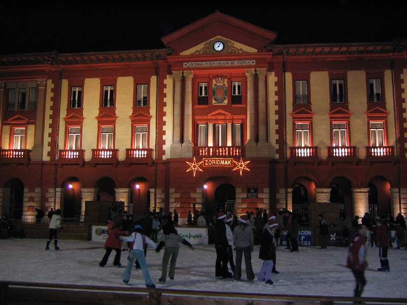
Eibar town hall
Eibar
Eibar town hall stands on the main square of Eibar, a town in the Gipuzkoa province of the Basque Country in northern Spain, and it has served as the seat of local government for more than a century. What is the history behind the building? The previous town hall, known locally as Konzejokua, had fallen into such poor physical condition by the 1870s that residents began raising complaints about it. Mayor Félix Guisasola pushed for a replacement building, and by 1899 a formal project had been drawn up, calling for facilities roughly double the size of the old town hall. Construction was completed in time for the new building to open on September 14, 1901, an occasion celebrated with choral competitions, an exhibition of local industrial products, and a banquet for the townspeople. Who designed the building and what does it look like? The town hall was designed by architect Ramón Cortazar, based in San Sebastián. He drew up a three-story structure resting on a stone base, with a broad portico on the main façade opening directly onto the square. The design blends two influences: the restrained monumentality associated with Italian civic palaces and the classical features common to Basque town halls in the region, above all the arcaded galleries, or arkupes, that are a recognizable trait of public buildings across the Basque Country. The building as inaugurated in 1901 was originally U-shaped, with its open side facing the street closed off only by a small wooden porch. It did not take on its current appearance, with an enclosed inner courtyard, until 1961, when the structure was remodeled. How can visitors get there? The town hall sits right in the historic center of Eibar, on the town's main square, making it an easy landmark to find on foot from most surrounding streets. Eibar lies in the Basque Country, a region well served by rail and road links connecting smaller towns to the larger hubs of Bilbao and San Sebastián nearby. A walk through the old town center is generally enough to reach the building without needing further transport. What else is worth seeing nearby? For much of its modern history, Eibar was known as a significant industrial center, particularly for firearms and bicycle manufacturing, and that industrial past shaped much of the town's character and layout. The square in front of the town hall, with its view of the portico and arcades, is a natural spot to pause while exploring the center. It is worth taking a moment to look at the stonework of the façade and the proportions of the three-story structure, which give the building a formal presence despite the town's relatively modest size. When is the best time to visit? The Basque Country has a mild, humid climate with rainfall spread across the year, so packing for changeable weather is a good idea whatever the season. Spring and early autumn tend to offer more comfortable conditions for walking around town, ahead of and after the busier summer crowds drawn to the nearby coast. Frequently Asked Questions When was Eibar town hall built? The current building opened on September 14, 1901, replacing an earlier town hall that had fallen into disrepair. Who designed the building? It was designed by architect Ramón Cortazar of San Sebastián. Has the building's appearance changed over time? Yes. It was originally U-shaped with a wooden porch facing the street, and only took on its present façade, with an enclosed courtyard, after a 1961 remodel. Where exactly is the town hall located? It stands on the main square in the center of Eibar, in the Gipuzkoa province of the Basque Country.
-
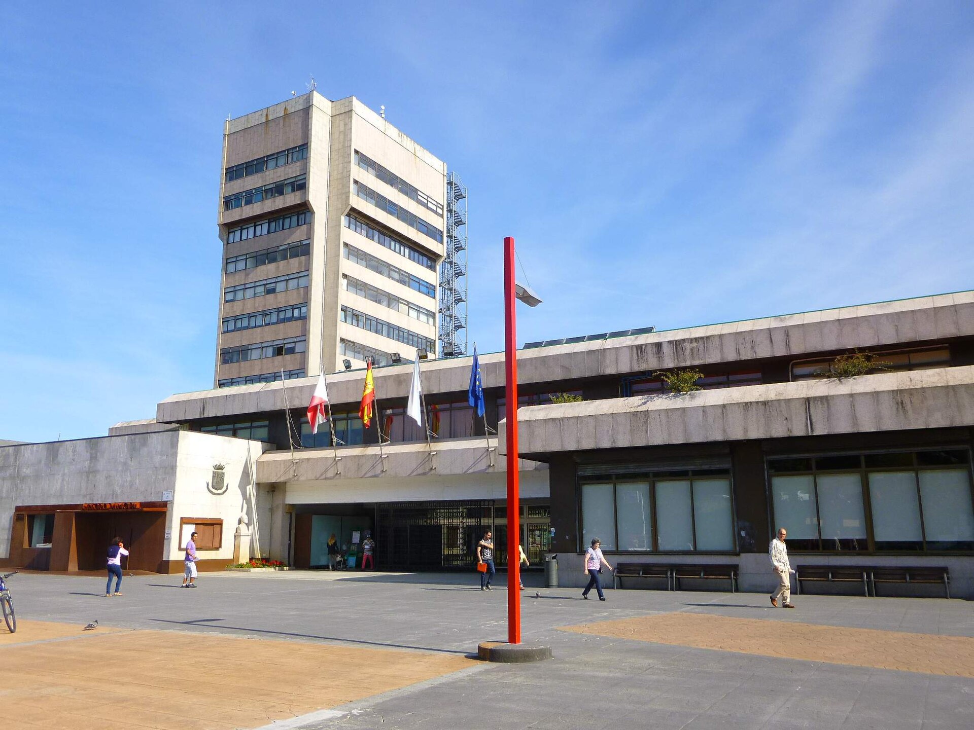
Vigo town hall
Vigo
Vigo Town Hall (Concello de Vigo) stands on Praza do Rei in the heart of this Galician port city, and its tall tower has become one of Vigo's most recognizable landmarks, visible from many points around town. Why is this building worth seeing? Vigo's previous town hall, built in 1859 on Plaza de la Constitución, eventually became too small — the city had grown past 250,000 residents and needed a larger seat of local government. The project for a new town hall was approved on 16 July 1971, and construction took more than four years to complete. The building was formally inaugurated on 26 July 1976 by King Juan Carlos I, accompanied by Queen Sofía. In honor of that occasion, the square in front of the building was named Praza do Rei (King's Square), and a bust of the king was placed near the entrance. The building itself is a striking example of 1970s modernist civic architecture: a low, horizontal base topped by a tall tower that houses several floors of municipal offices, including the Mayor of Vigo's office. That tower is the building's signature feature and one of the city's visual landmarks, visible from numerous vantage points across Vigo. What will you see on site? Walking through Praza do Rei, notice the contrast between the horizontal base and the soaring tower — a classic move in the modernist administrative architecture of that era. The square itself is a popular gathering spot for locals and a convenient starting point for exploring the surrounding shopping streets in central Vigo. It's worth knowing that the tower has needed renovation work for some time: the city has approved an 8.5-million-euro project to renew the tower's facade and fit it with a new, fully glazed roof. The work is meant to restore the building's original character and improve its condition after decades of use. How do you get there? Praza do Rei sits right in the center of Vigo, an easy walk from the main shopping streets and the port area. It makes a useful reference point while exploring downtown, easily reached from local bus stops and nearby parking. Because renovation work is ongoing around the square, part of the space may occasionally be fenced off or used as staff parking for the town hall — worth factoring into your walking route. When should you visit? The town hall can be admired from the outside year-round, and the square itself stays lively regardless of season. Afternoon light tends to work best for photographing the tower, when the sun hits the facade directly. If you're planning a trip in the coming months, keep in mind that renovation work on the tower and surrounding square may cause some temporary disruption. Frequently asked questions Can you go inside the town hall? The building serves as the seat of Vigo's municipal government, so public access to the interior is limited — it's primarily an administrative building rather than a tourist attraction with exhibits. Why is the square called Praza do Rei? The square is named after King Juan Carlos I, who formally opened the new town hall together with Queen Sofía in 1976. A bust of the king was placed near the entrance to mark the occasion. What stands out architecturally about the building? Its most recognizable feature is the tall tower rising above a low, horizontal base — a typical layout for modernist administrative buildings built in Spain during the 1970s. Are there other attractions nearby? Praza do Rei sits in central Vigo, close to the main shopping streets and within easy reach of the port area, making it a convenient starting point for exploring the rest of the city.
-
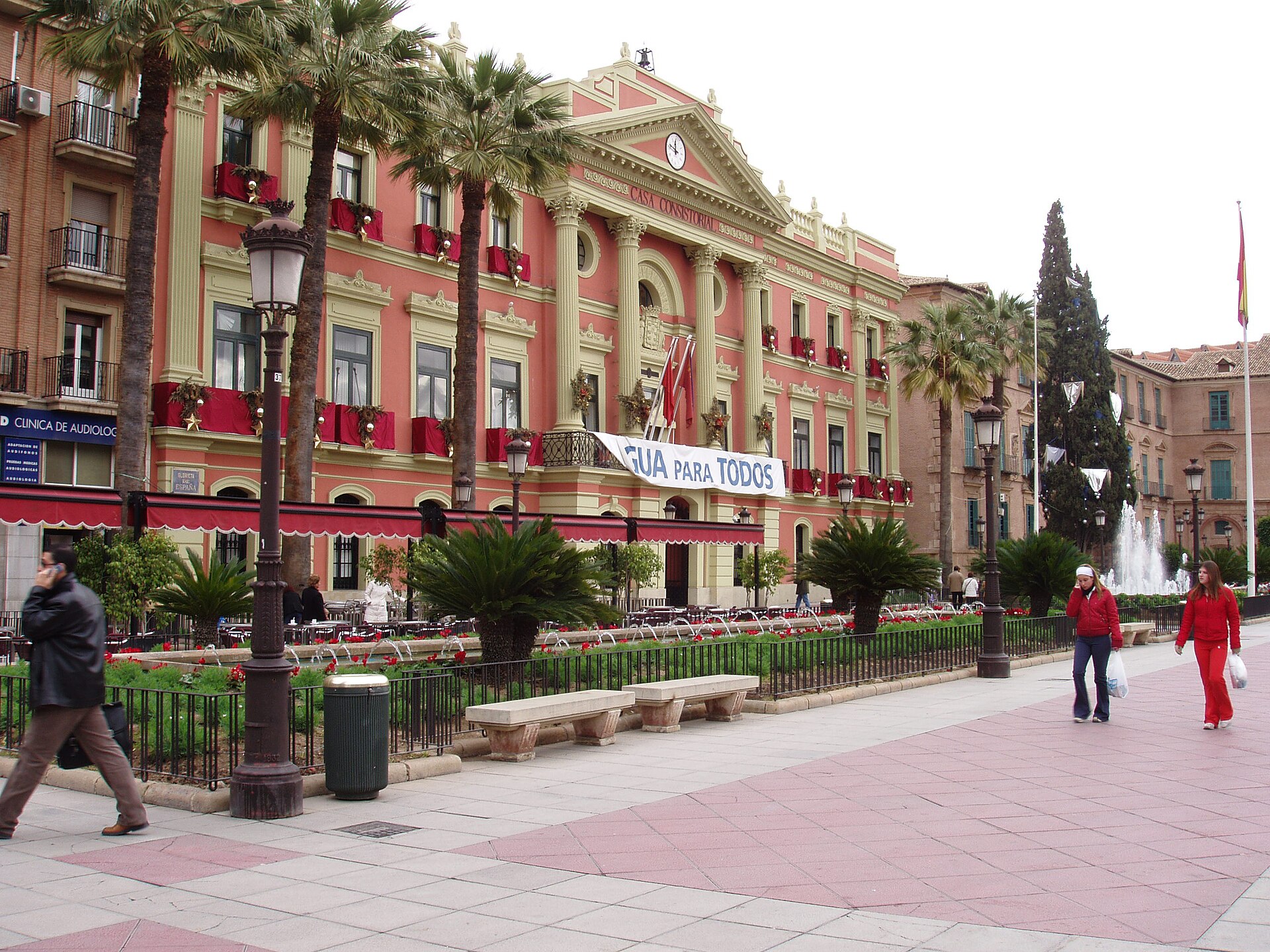
Murcia town hall
Murcia
Murcia Town Hall (Ayuntamiento de Murcia) sits right in the heart of the old town, on Plaza de la Glorieta, a stone's throw from the cathedral. It's the kind of stop most visitors pass without planning to — hard to miss it while walking through central Murcia — yet it rewards a closer look, since it actually combines two very different architectural eras under one roof. How do you get to Murcia Town Hall? The building stands in the fully pedestrian historic centre, so it's reachable on foot within minutes from almost anywhere in the old town. The easiest landmark to navigate by is Murcia Cathedral: the town hall and the cathedral face each other across Plaza Cardenal Belluga. Anyone exploring the old town on foot — by far the best way to see Murcia — will run into the town hall almost by default, on the way between the cathedral, the Casino Murciano, and the riverside promenade along the Segura. Drivers can leave the car at one of the underground car parks near Glorieta or Plaza Fontes and cover the centre on foot from there. What will you actually see? The town hall is, in effect, two buildings joined into one complex. The older section, facing Plaza de la Glorieta, is a 19th-century neoclassical structure commissioned by mayor Salvador Marín Baldo and designed by architect Juan José Belmonte. The site's administrative history goes back much further — the city council has occupied this same spot since medieval times, so the current building continues a function rather than starting a new one. The second, far more photographed part is the 20th-century extension by Rafael Moneo, one of Spain's most celebrated architects and a Pritzker Prize laureate. Once the original town hall had become too cramped, and with an empty plot available behind it on Plaza Belluga, mayor José Méndez Espino approved a new wing. The project was completed and opened in 1998, under mayor Miguel Ángel Cámara Botía. Moneo's façade is what draws every eye first — a bold, stone-clad composition conceived as a "façade-retablo," a monumental architectural altarpiece deliberately answering the theatrical baroque façade of the cathedral across the square. Built on a three-part composition that balances vertical divisions against horizontal bands, it's been regarded for years as one of the symbols of contemporary architecture in Murcia — the contrast between old and new plays out on a single, shared plaza. When is the best time to visit? The square in front of the town hall comes alive in the evening, once the heat eases off and locals stroll between the cathedral, the town hall, and the surrounding cafés. Spring and autumn are the most comfortable seasons for walking the old town — Murcia's summer afternoons get intensely hot, so it's worth saving this stretch for morning or early evening. Moneo's façade looks its best in late-afternoon light, when the stone takes on a warm glow. Frequently asked questions Can you go inside Murcia Town Hall? The building is a working municipal office, so interior access is limited to official business hours and matters. Visitors mostly view it from outside, from Plaza de la Glorieta and Plaza Belluga. Is visiting the town hall free? Yes — viewing both façades from the square is free and possible at any time of day. How much time should you set aside? Taking in both façades and the square takes about 10–15 minutes, though most visitors see it as part of a longer walk around the old town alongside the cathedral and nearby streets. Is the town hall connected to the cathedral? No, they're separate buildings, but they face each other on the same square and were designed to be in dialogue — Moneo's façade was conceived specifically as a visual answer to the cathedral opposite it.
-
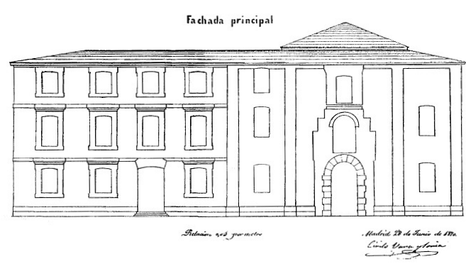
Colegio-convento de Agonizantes (Alcalá de Henares)
Alcalá de Henares
Colegio-convento de Agonizantes is a historic building right in the heart of Alcalá de Henares, at Plaza de Cervantes 12 — today the seat of the town hall (Ayuntamiento). At first glance it reads as a classic 19th-century municipal palace, but its story actually begins two centuries earlier, during the city's university golden age. How to get there? The building stands on Plaza de Cervantes, the main square of Alcalá de Henares, a short walk from the Alcalá de Henares train station (C-2 line from Madrid). This is the same square around which most of the historic center's landmarks cluster, so a visit pairs easily with a look at the nearby Universidad Complutense or the Magistral Cathedral. What will you see? The college-convent was founded in 1655 by Father Salvador Falconi, vice-provincial of the Order of Clerks Regular, Ministers of the Sick (the Camillians), after securing approval from both the Archbishop of Toledo, Baltasar Moscoso y Sandoval, and the university. Construction ran from 1652 to 1675. The friars of the Order of St. Camillus de Lellis had a duty to give spiritual comfort to people nearing death — which is why locals nicknamed the building Convento de Agonizantes, the "convent of the dying." After the Madoz secularization of church property in 1855, the convent was left empty. City officials moved quickly to claim the building for the town hall, formally securing it in 1868. Two years later, in 1870, architect Cirilo de Vara y Soria drew up a renovation plan that placed the town hall, the National Militia, and three schools inside the old complex. The rebuilding and refurbishment work continued until 1875. Since November 11, 1870, the building has served as the Palacio Consistorial — the seat of Alcalá de Henares's municipal government — a role it still holds today. Walking the square, it's easy to appreciate how a piece of 17th-century religious architecture was reshaped into a stately administrative building while keeping the original college's layout and proportions largely intact. When to visit? The best time to see the building is during weekday office hours, when the façade and entrance are visible without crowds. Plaza de Cervantes is most pleasant in spring and autumn, when the weather is comfortable for longer walks through the historic center and temperatures haven't climbed to the summer highs. Frequently asked questions Can you go inside the building as a visitor? As an active town hall, the interior isn't generally open for casual sightseeing — access depends on office hours and the purpose of the visit. Where does the name "Agonizantes" come from? From the Camillian order (St. Camillus de Lellis), who ran the convent here and were tasked with offering spiritual comfort to the dying — "agonizantes" in Spanish. Since when has the building been the town hall? Formally since 1868, and it has functioned continuously as the Palacio Consistorial since November 11, 1870. What else is worth seeing nearby? Plaza de Cervantes and the adjoining historic center of Alcalá de Henares, including the Universidad Complutense and the Magistral Cathedral, can all be covered on one walking route.
-
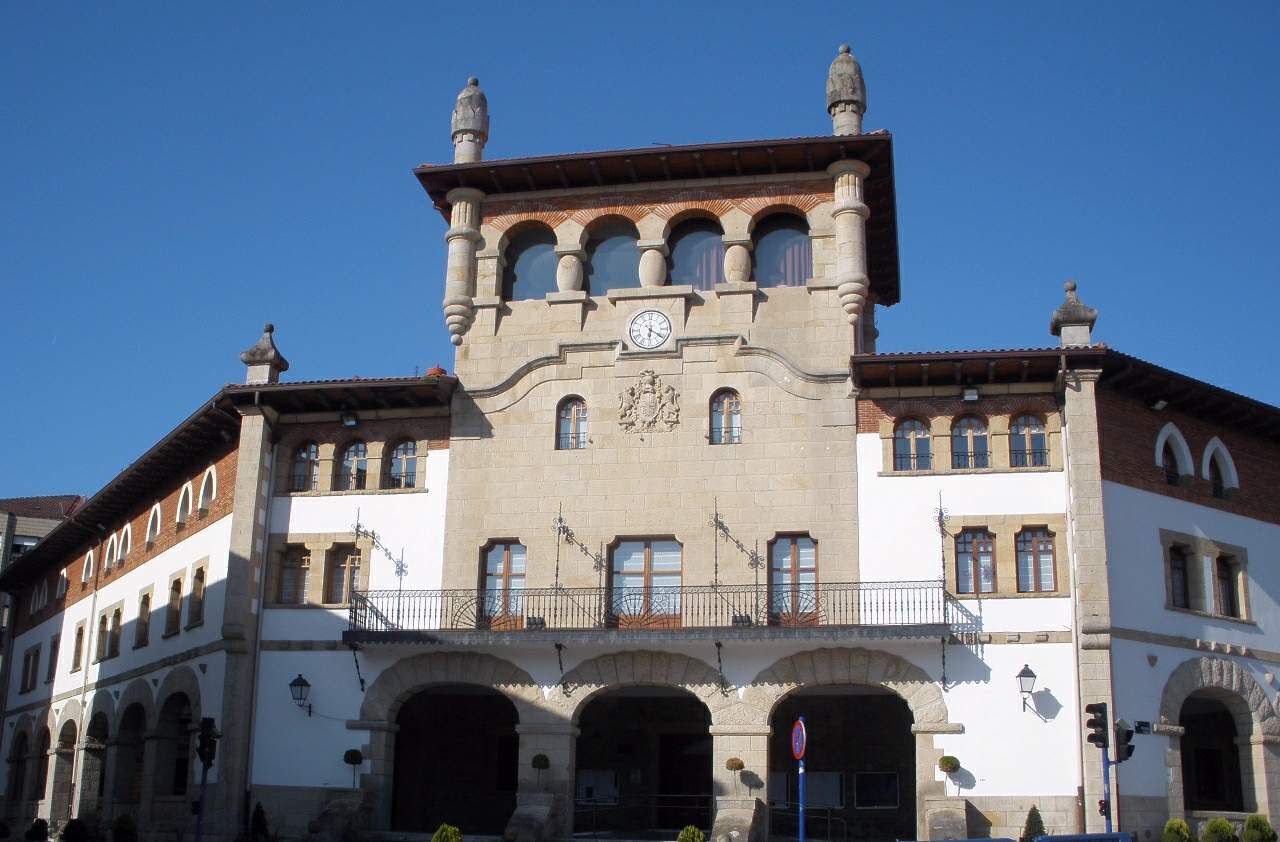
Mungia town hall
Mungia
Mungia Town Hall serves as the seat of local government for this small town in the Biscay province of the Basque Country. Standing right in the heart of Mungia, the building has remained one of the town's most recognizable landmarks for nearly a century, drawing the eye of residents and visitors alike. How do you get there? Mungia sits about 20 kilometers from Bilbao, reached via a well-signposted regional road. Driving is the most convenient option, with parking available near the main square in the town center. Travelers relying on public transport can catch one of the regular buses running from Bilbao to Mungia, a trip that typically takes 30–40 minutes. The town hall itself stands within the old town, so once you reach the center, it's just a short walk away. What will you see there? The current town hall building dates back to 1927. Its design drew on the neo-Cantabrian style, a movement popular in public architecture across northern Spain at the time. The most striking feature is the tower crowned with turrets, which dominates the façade and remains visible from many points around town. Buttresses reinforce the front of the building, while the second floor features pointed, Gothic-inspired windows. At street level, a wide portico opens onto the square — a design typical of Basque municipal buildings, historically used as a gathering space and informal trading area. The upper sections are finished in brick, creating a visual contrast with the stone base and marking a clear division between the building's levels. Above the portico sits a large coat of arms of the Anteiglesia de Mungia, along with a decorative corbel echoing Baroque detailing. The building's history hasn't been entirely peaceful. The original structure, completed in 1927, burned down during the Spanish Civil War on June 13, 1937. The reconstructed building preserved its original architectural character, and it remains a defining landmark of the town to this day. Today, the tower houses functions that go well beyond municipal administration: a public library, a media center, cinema screening rooms, and exhibition spaces. That mix keeps the building active not just as a seat of government, but as a genuine cultural hub for the local community. When should you visit? The town hall can be admired from outside year-round, and the square in front of it is freely accessible at any time. Late afternoon light works especially well for photographing the façade and tower, highlighting the texture of the stone buttresses and brickwork. If you're planning to step inside — to visit the library, an exhibition, or catch a film — it's worth checking opening hours in advance, since these can differ from the administrative offices' schedule. Spring and early autumn are the most comfortable seasons for exploring Mungia on foot, with mild temperatures and a quieter atmosphere around the town hall square compared to the larger cities of the Basque Country. Frequently asked questions Can you go inside Mungia Town Hall? Parts of the building serve public functions — the library, cinema rooms, and exhibition spaces are open to visitors during their respective opening hours. The administrative offices themselves aren't open to tourists. What architectural style is the building? It was designed in the neo-Cantabrian style, with clear Gothic touches (the pointed windows) and Baroque elements (the corbel and coat of arms). Is the current building the original from 1927? The original 1927 structure was destroyed by fire during the Spanish Civil War in 1937. The building standing today is a reconstruction that preserved the original architectural character. Is it worth combining a visit with the rest of Mungia's old town? Yes — the town hall sits within the historic center (casco histórico), so a single walk lets you take in other historic buildings nearby as well.
-
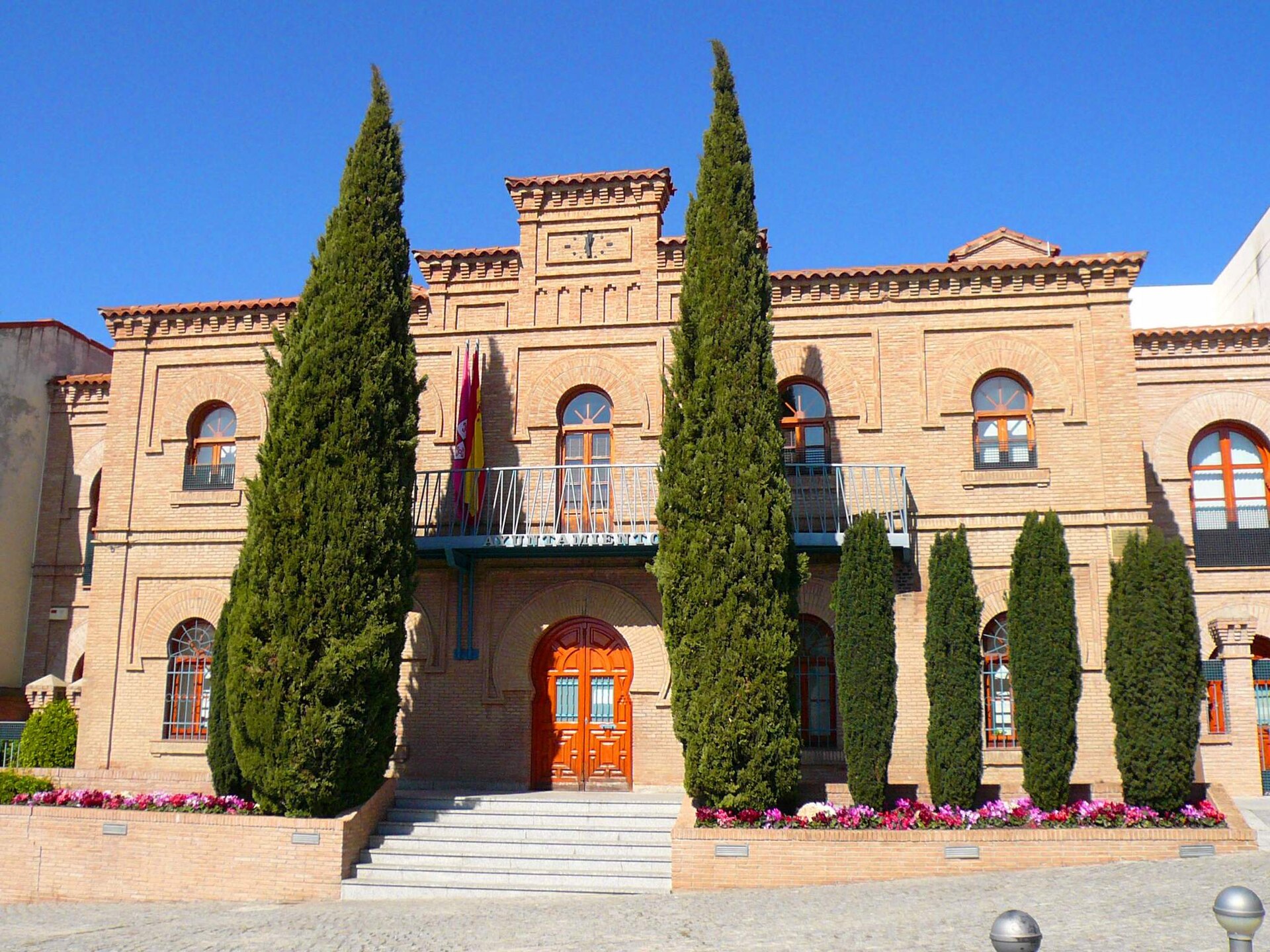
Illescas town hall
Illescas
Illescas town hall (Ayuntamiento de Illescas) stands on Plaza del Mercado, right in the heart of this small town in the province of Toledo, in the Castilla-La Mancha region. It's a building with a long and layered history, even though it has only housed the local administration for a few decades. How do you get there? Illescas lies less than 35 km south of Madrid, along the route connecting the capital to Toledo, making it an easy stop off the A-42 motorway. Regular buses run from Madrid (Plaza Elíptica station), with the journey taking roughly 40–50 minutes. Plaza del Mercado, where the town hall sits, is in the historic centre, within walking distance of the main parking areas and bus stops. What will you see? The town hall is actually made up of two buildings. The older one, built in neo-Mudéjar style, has a rectangular floor plan and a brick façade decorated with horseshoe arches framed in the characteristic alfiz border — a motif borrowed from Moorish architecture that became popular in Spain around the turn of the 20th century. Right beside it stands a newer building, opened in 2011, designed in a contemporary style but with a visual nod to the tower of the older section, so the two structures form a coherent whole despite belonging to different eras. The plot on which the town hall stands has a turbulent past. A prison occupied the site from 1582, later repaired and expanded during the 18th century. The building was likely rebuilt in the 19th century — the neo-Mudéjar façade that survives today dates from that period. It was largely destroyed during the Spanish Civil War, and after reconstruction it served as a vocational school. It has functioned as the town hall only since 2002. The square itself, Plaza del Mercado, has carried that name since at least the 18th century and has long been the centre of public life in Illescas — alongside the town hall, it's also home to the town's historic stone cross. When should you visit? Spring and autumn are the best times to visit Illescas, when temperatures across Castilla-La Mancha are more moderate — summer months (July–August) can be brutally hot, regularly climbing past 35°C. As a working administrative building, the town hall operates on weekdays during standard office hours, but the façade and square can be viewed year-round regardless of opening times. Why is it worth a stop? Illescas is best known for its ties to El Greco — the town holds several of the painter's works in its collegiate church and in the Hospital de la Caridad. The town hall isn't the main tourist draw, but it makes a good starting point for a walk through the historic centre, and it offers a clear look at how neo-Mudéjar motifs sit alongside a 21st-century design in a single complex. Frequently asked questions Can you visit the inside of Illescas town hall? As an active public administration building, it isn't set up as a tourist site with regular guided visits — access to the interior is limited to people with official business during office hours. Since when has the building served as the town hall? It has held its current function since 2002, though the plot itself has a much longer history — a prison stood here from the 16th century onward. What is the neo-Mudéjar style visible on the façade? It's a Spanish architectural style from the 19th and 20th centuries that draws on Moorish motifs, such as horseshoe arches and alfiz frames, and was popular for public buildings of that era. What else is worth seeing near the town hall? The town's historic stone cross stands on the same Plaza del Mercado, and the collegiate church and Hospital de la Caridad, both holding works by El Greco, are within easy walking distance.
-
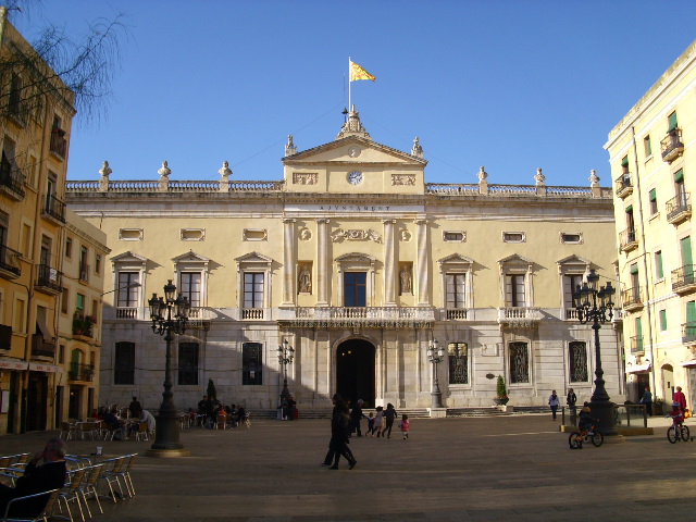
City Hall of Tarragona
Tarragona
The City Hall of Tarragona (Ajuntament de Tarragona) sits on Plaça de la Font, right in the heart of the old town of this Catalan city on the Mediterranean coast. How do you get there? Plaça de la Font lies within the walls of Tarragona's old town, just a few minutes' walk from the city's major Roman sites — the amphitheatre and the circus. It's the most convenient starting point for exploring the historic centre on foot, with narrow streets fanning out toward the cathedral and the Balcó del Mediterrani viewpoint. The Tarragona train station is a comfortable fifteen-minute walk away, and since the old town core is largely pedestrianised, drivers are better off parking on the edge of the historic district and continuing on foot. What will you see? Plaça de la Font itself occupies part of the site of the old Roman circus, a chariot-racing venue once woven into the layout of ancient Tarraco. The square takes its name from a well built here in the 14th century, around which the neighbourhood's public life gradually took shape. The town hall building, erected in the 19th century on the grounds of a former convent, is neo-gothic in style, with an Ionic-influenced façade and a distinctive clock tower that rises above the buildings lining the square. Inside the courtyard stands a two-tiered sarcophagus dedicated to King James I the Conqueror — a symbolic tribute, since the monarch's actual remains rest at the Poblet Monastery, a UNESCO World Heritage Site. The building on Plaça de la Font has served as Tarragona's seat of local government since 1852, when the council moved here from what is now known as the Antic Ajuntament, the former city hall that had held this role from the 15th century until the mid-19th century. The square around the town hall is lively throughout the day, ringed by cafés and restaurant terraces that make it a natural resting point between visiting the Roman ruins and exploring the cathedral quarter. When should you visit? Tarragona has a classic Mediterranean climate, so spring (April to June) and early autumn (September and October) offer the best balance of mild temperatures and lighter crowds compared to peak summer. The square can get warm at midday in summer, but comes alive in the evenings once the restaurant terraces fill up. Try to time your visit for late afternoon, when the low sun gives the façade and clock tower a warm golden tone. Practical tips The City Hall is primarily an administrative building, so its interior isn't generally open to visitors — the draw here is the architecture, the square, and the historical setting rather than a guided tour. It's easy to pair a visit with a short walk to the remains of the Roman circus, traces of which are still visible in the surrounding streets, and to the Antic Ajuntament, the city's former seat of government, just a few minutes away on foot. Frequently asked questions Can tourists go inside Tarragona's City Hall? The building functions as a working administrative office, so interior access is limited — visitors mainly view the façade, clock tower, and the surrounding Plaça de la Font. Since when has the City Hall been in its current location? The municipal government moved to Plaça de la Font in 1852; before that, the city was governed from the building now known as the Antic Ajuntament. What does the name Plaça de la Font mean? The name refers to a well ("font" in Catalan) built on the square in the 14th century. Are there other Roman sites near the City Hall? Yes — the square sits on part of the old Roman circus, and the Roman amphitheatre and the walls of ancient Tarraco are both within easy walking distance.
-
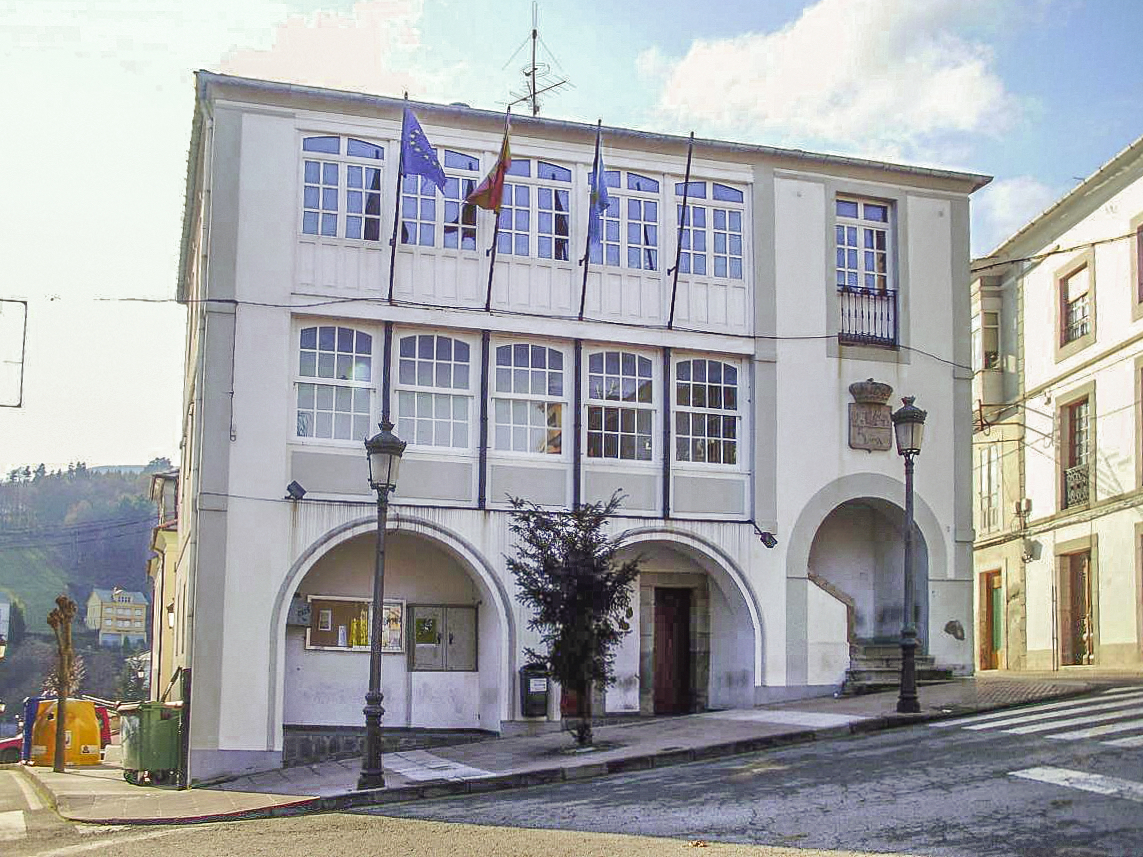
Boal town hall
Boal Town Hall (Ayuntamiento de Boal) stands on Plaza del Ayuntamiento, right at the heart of this small municipality in western Asturias, along the Navia river. It's the most recognizable public building in town and a natural starting point for exploring the surrounding area. How do you get there? Boal sits deep in western Asturias, in the Navia river valley, surrounded by the Doiras and Arbón reservoirs and the ranges of El Coto, San Isidro, Santín and Penouta. The town hall is literally in the center of town, so once you reach Boal, finding the main square is straightforward — there's no need to hunt for extra directions or separate parking outside the center. It makes a solid base before heading out to the nearby viewpoints or reservoirs. What will you see on site? The building represents the popular architecture typical of the early 19th century in this region — modest in form but sturdily built, characteristic of local Asturian government seats of that era. It underwent a recent restoration, so its facade retains a clearly historic character even though the building still functions as an active administrative office. This isn't a museum-style attraction to walk through — it's a living part of the municipality's daily life, best appreciated from outside while strolling the square. What's the history behind it? Boal's council became administratively independent and drafted its first bylaws in 1584, with Boal as its seat. Even so, the area went without a dedicated town hall and jail building for centuries — such a structure wasn't built until after 1824, and the actual town hall and jail opened in 1842, a year after the building itself went up in 1841. That gives the structure nearly two centuries of continuous use as the municipality's administrative center. The municipal archive kept in connection with the town hall is a genuine trove for regional historians: eight volumes of tax records spanning 1525–1799, two books of council minutes from 1719–1799, and civil registry books from 1841–1869, back when the town administration handled that function. When's the best time to visit? Boal is worth timing around its local events — October brings the Feria de Otoño (autumn fair), and November hosts the Certamen de la Miel, a honey festival tied to the region's beekeeping tradition, which the nearby Casa de la Apicultura explores in more depth. Spring and summer are also ideal for trips to the Penouta viewpoint overlooking Asturias's western coast, or for visiting the Pendía hillfort, one of the region's most significant prehistoric settlements. Frequently asked questions Can you go inside Boal's town hall? The building is an active administrative office, so interior access is limited to office hours and official business. The facade and square, however, can be viewed freely at any time. What else is worth seeing near the town hall? Within the municipality you'll find the Centro de Interpretación de la Emigración in San Llouguís, dedicated to indiano architecture, the Casa de la Apicultura, and the prehistoric Pendía hillfort, with an acropolis and settlement separated by a defensive wall. Is Boal a good base for exploring Asturias? Yes — its proximity to the Doiras and Arbón reservoirs, the Navia river valley, and viewpoints like Penouta make Boal a convenient base for nature lovers and active tourism in the western part of the region. Where do the archival records kept at the town hall come from? The municipal documents, including tax records dating back to 1525, have been collected continuously since the council gained administrative independence in 1584, making them one of the oldest surviving collections of their kind in the region.
-
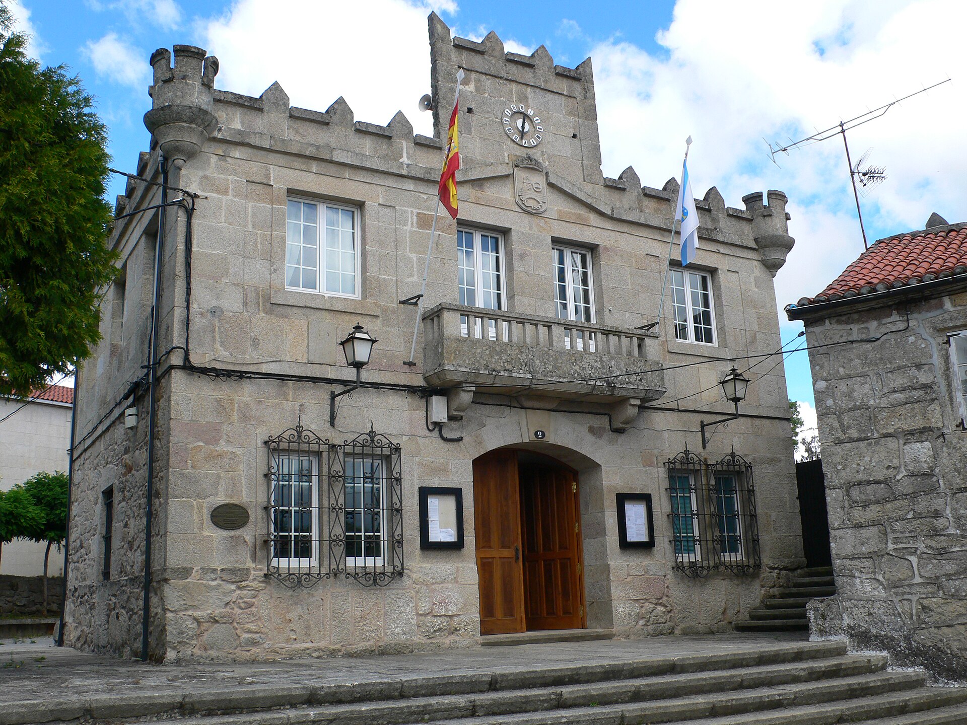
Rodeiro town hall
Rodeiro
Rodeiro Town Hall (Casa do Concello de Rodeiro) sits at the heart of this small municipality in the province of Pontevedra, in Galicia, northwest Spain. Where exactly is it located? The building stands at Praza do Concello 2, right in the middle of Rodeiro (postal code 36530). It's the easiest landmark to spot in town — just head to the main square and you'll find it. Its coordinates, 42.6496, -7.9501, are handy if you're mapping out a driving route through the Pontevedra countryside. What's the history behind this spot? The current town hall didn't rise on just any plot of land. It occupies the site of the former Fortaleza de Rodeiro, a medieval fortress dating back to the 14th century. That's worth knowing before you arrive: a modern administrative building now sits on ground that once held a defensive stronghold, which explains why it commands such a prominent, central position on the square. The old fortress itself is no longer standing in a visitable form, but its former presence remains part of Rodeiro's local history and identity. What will you actually see there? Right in front of the entrance is a stone fountain with four spouts — a small but distinctive feature that many visitors photograph as their first stop when walking through town. It's a good spot to pause for a moment before continuing your walk around Rodeiro. The building itself functions as the seat of the municipal government, so its interior is used mainly by residents handling official business rather than by tourists on a sightseeing route. How do you get there? Rodeiro lies inland in the province of Pontevedra, in the Galicia region — a small municipality best reached by car via the local roads connecting it to the region's larger towns. Once you reach the town centre, just head for the main municipal square, and you'll spot the town hall right away thanks to its prominent position and the fountain out front. When is the best time to visit? Since the town hall is primarily an administrative building rather than a sight with set visiting hours, it's best seen during the day, while the office is open — that's when the square in front of it feels most alive and the surrounding streets of Rodeiro are easiest to explore. It's worth pairing a look at the building with a short stroll through the town centre, since you'll already be right there. Frequently asked questions Can visitors go inside the town hall? The building houses the offices of Rodeiro's municipal government, so access is mainly for people handling administrative matters. Most travellers simply view it from outside, along with the square and fountain. What's right in front of the building? A stone fountain with four spouts — a small but recognisable feature of the square, worth a quick look while you're there. Does the town hall have any historical significance? Yes — it stands on the site of the former Fortaleza de Rodeiro, a 14th-century medieval fortress, which makes the location historically significant for the town, even though the fortress itself no longer survives. What's the easiest way to reach Rodeiro? Driving is the most practical option, using the local roads within Pontevedra province. Once you're in the town centre, the town hall is easy to find on the main square.
-
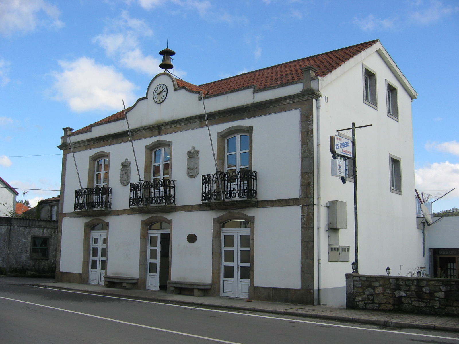
A Baña town hall
A Baña
A Baña town hall (Casa do Concello) serves as the seat of local government for A Baña, a small municipality in the province of A Coruña, Galicia. Standing on Praza do Concello, the building acts as a natural landmark for travelers passing through this part of the Barcala area. Where is it located? A Baña sits roughly 30 km west of Santiago de Compostela, within the comarca of Barcala. The municipality covers just under 100 km² at an average elevation of around 270 meters, and is home to a little over 3,000 residents. Fields, forests and river valleys still shape the landscape far more than any built-up area. Why stop here? The town hall itself isn't a grand tourist monument, but it makes a sensible starting point for exploring the surrounding countryside. A Baña lies along one of the stages of the Camino de Santiago, so pilgrims and hikers regularly pass close to the municipal building. It's also the place to ask locals about nearby trails, tourist information or upcoming cultural events. Nearby, look out for the medieval parish church of San Vicente de A Baña and the region's traditional granaries — hórreos built in the xalleiro style. These raised stone-and-wood structures have been used for centuries to store grain and corn while keeping it away from damp and rodents. What to do around here The municipality is known for the Barcala and Tambre rivers, both popular with trout anglers. Oak and chestnut woodlands invite easy walking, and the Área Recreativa de Chans is a favorite spot among locals for a picnic or some time by the water. It works well as a base for anyone wanting genuine countryside without straying far from Santiago de Compostela. How to get there A car is the most practical option — the drive from Santiago de Compostela takes around 40 minutes along local roads. A Baña has no train station of its own, so public transport relies mainly on regional buses connecting the municipality with the larger towns of the A Coruña province. When to visit Spring and summer bring out the best in the river valleys and forests, and offer the most comfortable conditions for fishing and hiking. Autumn, meanwhile, turns the chestnut woods into a striking display of color, which landscape photographers tend to appreciate. Frequently asked questions Is A Baña town hall a tourist attraction in its own right? It's primarily an administrative building rather than a museum, but it's worth seeing as a landmark while exploring the municipal center and the nearby parish church. How far is it from Santiago de Compostela? About 30 km, roughly a 30–40 minute drive. What else is worth seeing in the A Baña municipality? The medieval church of San Vicente de A Baña, traditional xalleiro-style hórreos, and the Barcala and Tambre rivers, both good for trout fishing. Does the Camino de Santiago pass through A Baña? Yes, the municipality lies on one of the stages of the Way of St. James, making it a common stopping point for pilgrims.
-
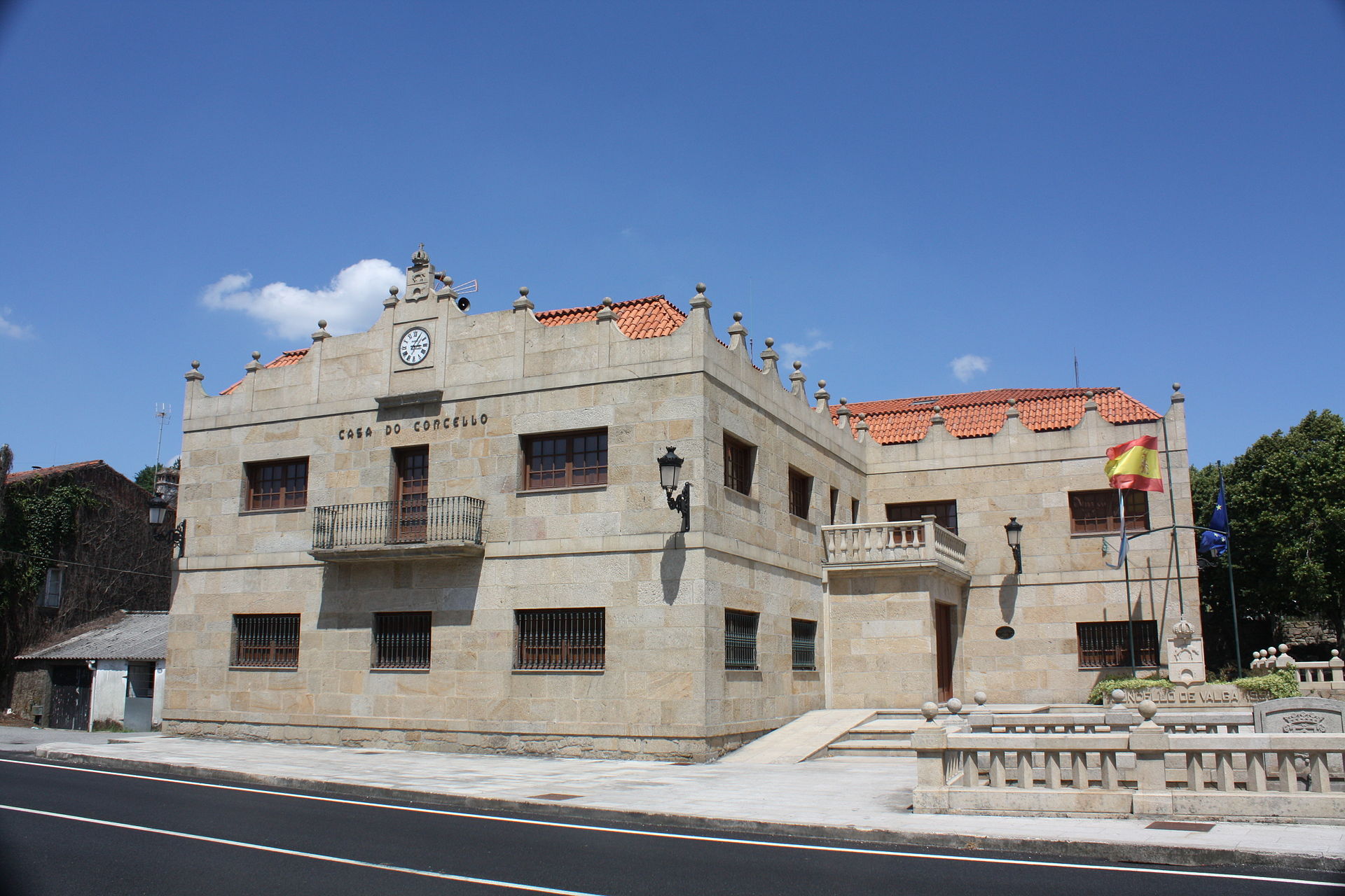
Valga town hall
Valga
Valga Town Hall, in the Galician municipality of Valga, sits on the left bank of the Ulla River in Pontevedra province, right in the heart of Spain's Rías Baixas region. Which Valga is this? There's another Valga on the map — a border city in Estonia, next to Latvia — but this one has nothing to do with it. The Galician Valga sits in northwestern Spain, roughly between the towns of Padrón and Caldas de Reis. Its neighbors are Dodro, Pontecesures and Padrón to the north, Catoira and Caldas de Reis to the south, Cuntis and A Estrada to the east, and Rianxo and Dodro to the west. The municipality itself is made up of five parishes — Campaña, Cordeiro, Setecoros, Xanza and Valga — and the town hall building stands at Avenida Coruña, 14. How do you get there? Padrón is the closest town of any size, and the drive from there along the Ulla river road takes only about fifteen minutes. Santiago de Compostela airport is the nearest air link, roughly 30–40 minutes away by car. Two branches of the Camino de Santiago cross municipal territory — the Camino Portugués and the river-and-sea Ruta Marítima Fluvial — so a fair number of visitors pass through simply because they're walking to Santiago. What's worth seeing around the town hall? The council building itself isn't a monument open for tours, but it makes a sensible base for exploring the rest of the municipality. Close by stands the 11th-century Romanesque church of Santa María de Xanza, commissioned by archbishop Diego Xelmírez — one of the region's oldest and most valuable religious buildings. The older Igrexa Vella de Santa Comba de Louro and the small, early Christian Capela dos Martores are also worth a look. Nature lovers should head for the Parafita and Raxoi waterfalls, the slopes of Monte Xiabre, or the restored windmill at Molino de Viento de Beiro. Down by the river, the Área Recreativa de Ponte Valga offers a picnic spot on the Ulla, and a little further out the Pedra da Serpe petroglyph points to much older human presence in the area. Where's the best view over the valley? Two lookout points stand out. Mirador Monte da Perdiz overlooks the Valga river valley, while Mirador de Beiro, set beside an old windmill, pairs the landscape with a piece of local craft history. When should you visit? Outside the summer months, when the surrounding countryside is best explored on foot or by bike, two dates are worth marking. The Belén Artesanal en Movimiento — a moving nativity scene in the village of Campaña, recognized as a tourist attraction of regional interest — runs from the first Sunday of December through the second Sunday of January. In summer, a local festival celebrates eel and aguardiente, the Galician grape-pomace spirit, also listed among the region's events of touristic significance. Frequently asked questions Is this the same Valga as the one in Estonia? No. They're two separate places that happen to share a name — the Spanish Valga is in Galicia's Pontevedra province, while the Estonian Valga is a border town next to Latvia. Can you go inside the town hall as a visitor? It's a working municipal office, not a museum, so there's no visitor route — the building handles residents' administrative business rather than tours. Where's a good base for exploring the area? Padrón or Santiago de Compostela both work well; the drive to Valga is short and follows the scenic Ulla river valley. What's the connection between Valga and the Camino de Santiago? Two official pilgrim routes, the Camino Portugués and the river-and-sea Ruta Marítima Fluvial, run through the municipality, making Valga a regular stop for pilgrims heading to Santiago de Compostela.
-
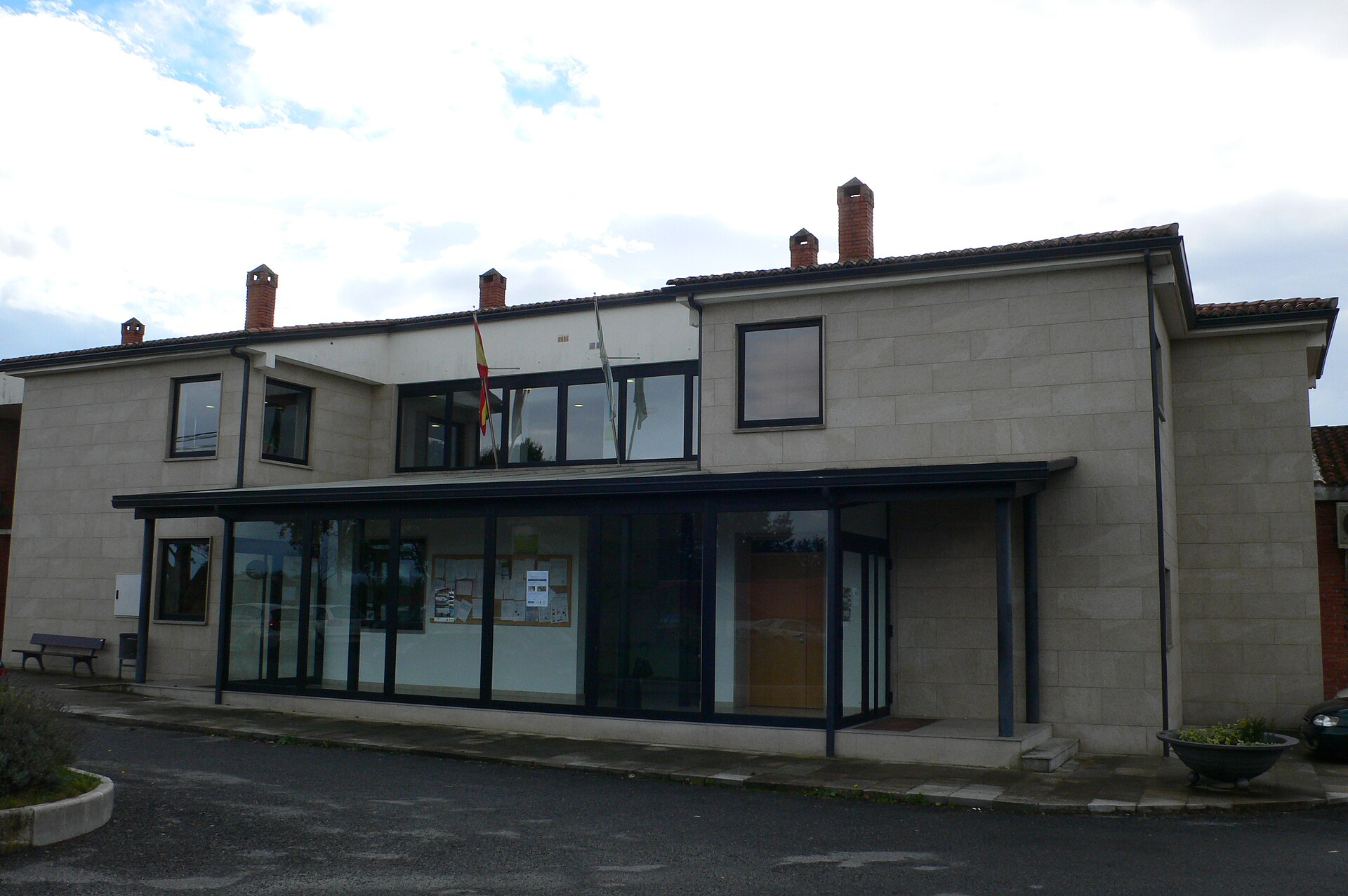
Amoeiro town hall
Amoeiro
Amoeiro town hall is the seat of local government for the municipality of Amoeiro, in the province of Ourense, deep in inland Galicia in northwestern Spain. The building sits on the Os Chaos plateau, a short drive from the city of Ourense, and works as a natural starting point for anyone exploring this small but heritage-rich municipality. Where is Amoeiro exactly? Amoeiro spreads across flat, fertile land covered in pine and eucalyptus woodland, in a valley northwest of the Miño river. It borders Coles to the east, Vilamarín and San Cristóbal de Cea to the north, the city of Ourense and the municipality of Punxín to the south, and Maside to the west. The town hall stands in the village of Amoeiro itself, the administrative hub of an area split into eight parishes: Abruciños, Amoeiro, Bóveda de Amoeiro, Cornoces, Fontefría, Parada de Amoeiro, Rouzós, and Trasalba. Why start a visit here? The town hall building itself is purely functional — locals come here to handle municipal paperwork — but its real value to a visitor is location. Amoeiro packs a dense concentration of rural Galician heritage into a small area: prehistoric petroglyphs, Romanesque churches and bridges, traditional raised granaries called hórreos, stone crosses (cruceiros), and a striking number of old manor houses known as pazos. What's worth seeing nearby? The standout site is the Pazo de Trasalba, built in 1764 and now run as a house-museum dedicated to the Galician writer Ramón Otero Pedrayo. It holds his personal library and regularly hosts cultural events tied to regional literature and history. In the parish of Bóveda de Amoeiro, a Romanesque church has preserved artistic elements from earlier centuries. And in Santa María de Amoeiro, the square known as O Campo da Igrexa displays a cluster of traditional hórreos — the stilted stone or wooden granaries typical of Galician villages. How do you get to Amoeiro? Driving is the most practical option: Ourense is under 20 kilometers away, and the trip takes roughly 20–25 minutes on local roads. Ourense itself is well connected by train and bus to the rest of Galicia and Spain, making it the logical base for travelers without a car, who can then continue by local bus or taxi. When is the best time to visit? Spring and early autumn offer the most comfortable conditions for exploring this part of Galicia, with mild temperatures and the Os Chaos plateau's farmland and forests at their most photogenic. Summer runs warmer but coincides with local parish festivals, when the municipality's folk traditions come to life. Frequently asked questions Can you visit the inside of Amoeiro town hall? It's a working administrative building, so access is limited to office hours and official business — it isn't set up as a visitor attraction. How far is Amoeiro from Ourense? About 18–20 kilometers, roughly a 20–25 minute drive. What shouldn't you miss in the Amoeiro municipality? The Pazo de Trasalba house-museum dedicated to writer Otero Pedrayo, the Romanesque church in Bóveda de Amoeiro, and the hórreo cluster on the O Campo da Igrexa square in Santa María de Amoeiro. Does Amoeiro have much tourist infrastructure? It's a small, rural municipality, so most accommodation and services are best planned in nearby Ourense, from where Amoeiro works well as a day trip.
-
Berlanga de Duero town hall
Berlanga de Duero
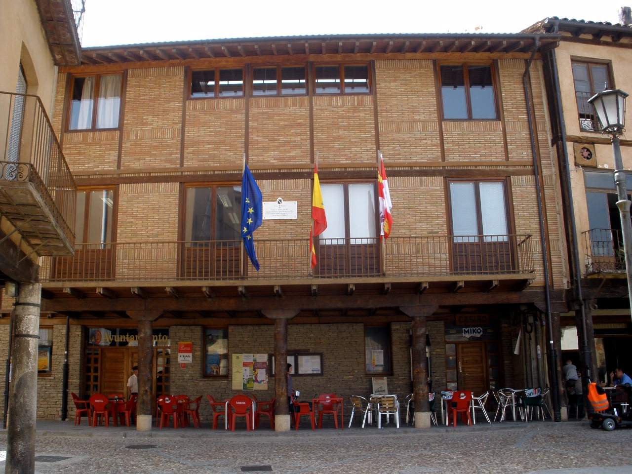
Berlanga de Duero Town Hall occupies a prominent spot on the Plaza Mayor in Berlanga de Duero, a small town in Soria province, in the Castile and León region of Spain. The building forms part of the porticoed square that has served as the town's administrative and social hub for centuries. Where exactly is the town hall located? The town hall sits at Plaza Mayor 1, within the historic core of Berlanga de Duero. The whole old town has been declared a historic-artistic ensemble, so the streets and porticoes surrounding the building fall under heritage protection. Visitors typically enter the square through the Puerta de Aguilera, one of the historic gateways leading onto the Plaza Mayor. What can you see around the square? The Plaza Mayor where the town hall stands is a classic example of Castilian porticoed architecture: wooden posts resting on stone bases form arcades that run along the buildings facing the square. The layout dates back to the 16th century, and some of the stone bases reuse older Romanesque capitals salvaged from churches that stood in Berlanga before the town's collegiate church was built. This square functions as the true center of town life, with the town hall and several other public offices lining its edges. Berlanga de Duero also carries more history than its size would suggest. According to the General Chronicle of 1344, King Alfonso VI granted the lordship of Berlanga to El Cid Campeador in 1089 as a reward for his services to the crown. This episode is still woven into how locals present the town's story, and it's one of the details that makes a stop at the square more than just an architectural visit. How do you get there? Berlanga de Duero lies in Soria province, an area not served by major rail lines, so arriving by car is the most practical option. The town connects via local roads to Soria, the provincial capital, and to Almazán. Once there, park near the old town and continue on foot — the historic center is compact enough that the Plaza Mayor and nearby landmarks are all within easy walking distance. When is the best time to visit? Spring and early autumn bring the most comfortable conditions on the Soria plateau, with mild temperatures suited to walking around the square and the rest of the old town. Summers can turn hot and dry, while winters carry the sharp continental chill typical of inland Castile. Visiting in the afternoon lets you take advantage of the shade cast by the porticoes, making the square a pleasant place to pause during a longer walk through town. What else is nearby? Berlanga de Duero is also known for its hilltop castle and its collegiate church, both within easy reach of the Plaza Mayor. The town hall makes a natural starting point for exploring these sites, since the square connects directly to the streets leading toward the rest of the old town's landmarks. Frequently asked questions Can visitors go inside the town hall? The building is an active administrative office, so interior access is limited to office hours and official business. The square and the building's façade, however, are open to visitors at any time. Is there an entrance fee for the Plaza Mayor? No, the square is a public space and can be visited freely at any time. How much time should you set aside for this spot? Seeing the square and town hall itself takes about 15–20 minutes, but combined with the nearby castle and collegiate church, a visit to Berlanga de Duero usually takes 2 to 3 hours. Are there places to eat nearby? Local bars and restaurants line the porticoes of the Plaza Mayor, offering traditional Castilian dishes for visitors after sightseeing.
-
San Martín de Trevejo town hall
San Martín de Trevejo
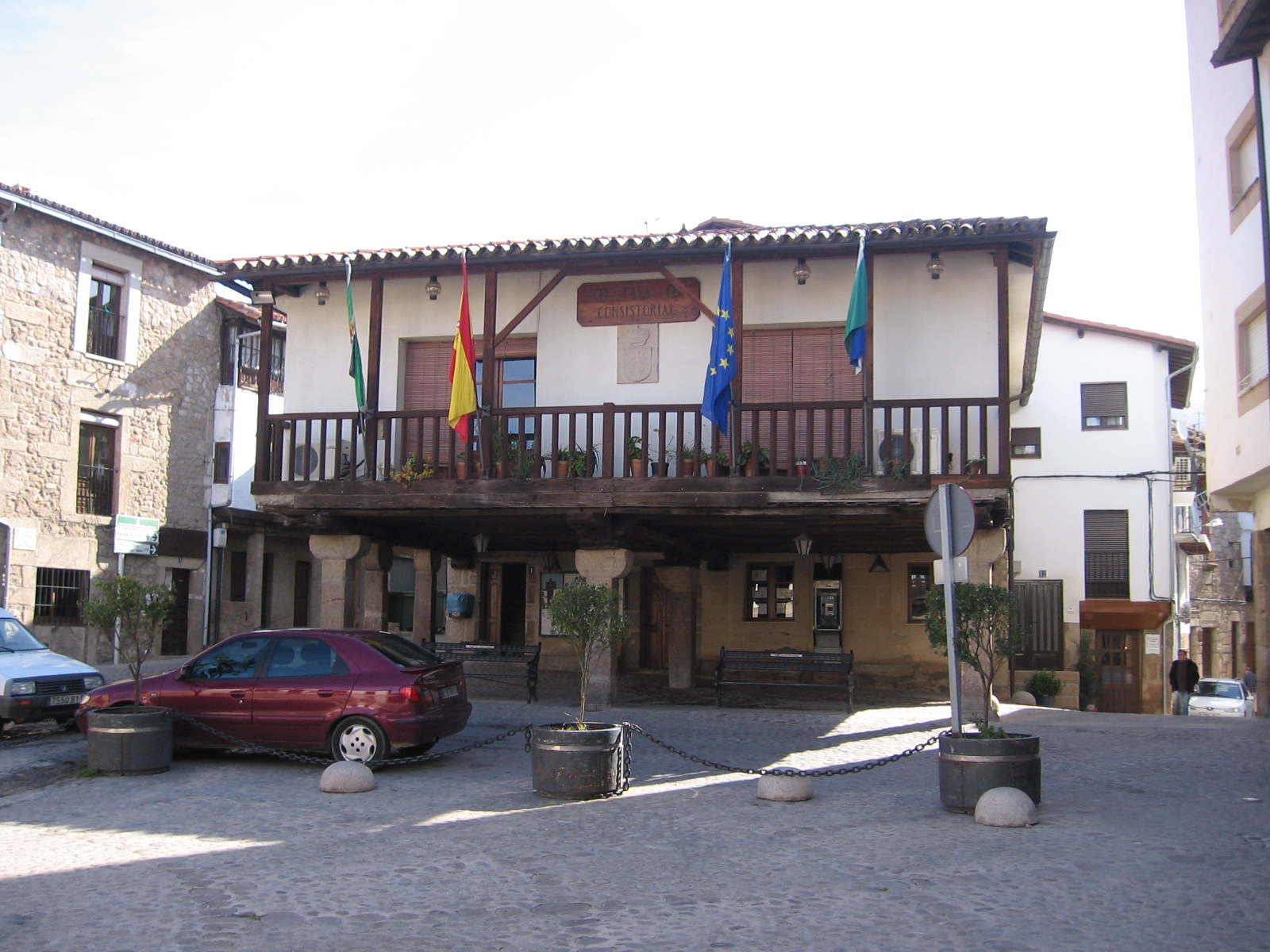
San Martín de Trevejo's town hall sits right at the heart of one of the best-preserved villages in the Sierra de Gata, in the province of Cáceres, Extremadura. The building faces the Plaza Mayor, an arcaded square built around a stone trough, or pilón, that has served as the village's social hub for centuries. Where exactly is it located? San Martín de Trevejo lies less than 20 km from the Portuguese border, within the Sierra de Gata comarca. The town hall stands on the main square, surrounded by the timber-and-adobe houses typical of this corner of Extremadura, among which a few old mansions stand out, including the Palacio del Comendador and the Palacio de Ojesto. This part of the village, together with its network of narrow lanes where spring water sometimes runs along the street, has been declared a Bien de Interés Cultural under the Conjunto Histórico category, meaning the whole historic quarter is protected as a single ensemble. What's worth seeing near the town hall? The square itself is the natural starting point for a walk through the village. Its arcades offer shade during the hot months and draw the eye toward the central pilón, a traditional watering trough that has doubled as a meeting spot for residents for generations. A short walk away stands the parish church of San Martín de Tours, a three-nave building that houses three panels painted by Luis de Morales, a 16th-century painter from Badajoz known as "El Divino." It's also worth reaching the former San Miguel convent, a 15th-century building — the only one of its kind still standing intact across the whole Sierra de Gata — which today operates as the region's tourism-run guesthouse. What makes this place distinctive? San Martín de Trevejo is one of only three villages in the Sierra de Gata — alongside Eljas and Valverde del Fresno — where a language called "a fala" is still spoken, a variety descended from a blend of Leonese and Galician-Portuguese. The local strand is known as mañegu, and it can still be heard around the town hall square, at markets, and during village festivities. It's a living piece of heritage that sets a visit here apart from touring a typical Extremaduran town: the architecture and the language together shape an identity found nowhere else in Spain. How do you get there, and when should you visit? Driving is the most practical option, with Coria as the nearest larger town before regional roads lead into the Sierra de Gata. Spring and early autumn are the best times to walk the historic quarter, since temperatures stay mild and fruit trees in bloom add extra colour to the surrounding landscape. Summers in Extremadura can turn very hot, so mornings are the better window for exploring, when the square's arcades still offer plenty of shade. What else is nearby? The wider Sierra de Gata is dotted with similar stone-built villages — Eljas, Valverde del Fresno and Gata are all just a short drive apart, making it easy to combine several stops in a single day. The comarca is also known for its olive oil and honey production, and hiking and cycling routes run through the hills surrounding the valley. Frequently asked questions Can you go inside the town hall? It's an active municipal administration building, so interior access is limited to office hours and official business — visitors mainly see it from the outside, standing in the Plaza Mayor. How long does it take to see the area around the town hall? The square and the nearby lanes of the old quarter can be covered in 30–45 minutes, but allow 2–3 hours if you also want to visit the parish church and stroll through the wider historic centre. Is Portuguese spoken in San Martín de Trevejo? Not exactly — the local language is "a fala," specifically its mañegu variety, formed from a mix of Leonese and Galician-Portuguese. It's a distinct, living dialect rather than standard Portuguese. Is it worth pairing this visit with other Sierra de Gata villages? Yes — distances between the comarca's villages are short, and each has its own architectural character, which is why a day trip covering several of them is a popular way to explore the region.
-
Cervià de les Garrigues town hall
Cervià de les Garrigues
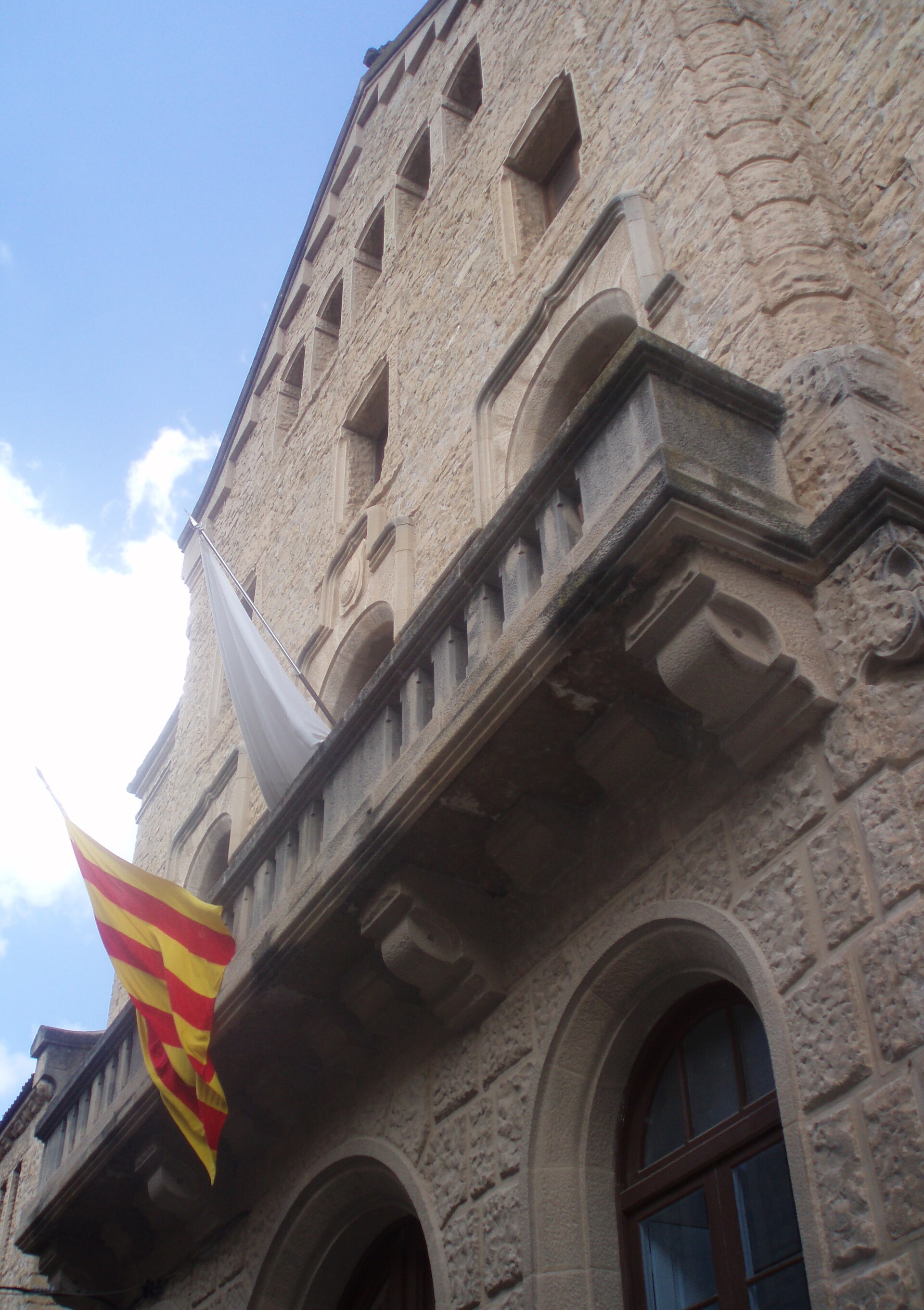
Cervià de les Garrigues Town Hall sits at the heart of this small village of fewer than 650 residents in the Les Garrigues district, in the province of Lleida, Catalonia. What makes the building worth a look? The current town hall opened its doors in 1913. It was designed by architect Morera i Gatell in a modernist style and built entirely from local stone, a fitting choice in a landscape defined by dry, rocky terrain. It still functions today as the seat of the municipal government and is widely regarded as one of the village's most distinctive pieces of architecture. How do you get there? Cervià de les Garrigues lies roughly 48 km from Lleida, about a 35-minute drive along local roads that wind through hills planted with olive and almond trees. The village sits in the valley of the Set river, at an altitude of around 443 metres. The town hall stands right in the village centre, next to the parish church, so most visitors take them in together on a short walk. What else is there to see nearby? Right beside the town hall is the parish church of Sant Miquel Arcàngel, with a classical facade topped by a triangular pediment and a small rose window — a natural second stop on any short walk through the centre. Visitors with more time can follow the route to the nearby hamlet of les Besses, where the remains of a medieval feudal castle survive alongside a scattering of old houses, the church of Santa Maria de les Besses, and an old mill. It's a good way to place the town hall within a much older layer of the region's history. Cervià and its surroundings are also known for extra virgin olive oil, whose quality is recognised well beyond the borders of the Les Garrigues district. Many visitors combine a stop at the town hall with a tasting at one of the nearby oil mills. When is the best time to visit? The Les Garrigues district has a dry Mediterranean climate, so the most pleasant conditions for exploring fall in spring (April–May) and autumn (September–October), when temperatures are mild and the surrounding hills are green with olive groves. Summers can be very hot and dry, worth factoring in if you plan longer walks around the area. Frequently asked questions Can you go inside the town hall? It's a working municipal building, so interior access is limited to office hours. The facade and exterior architecture, however, can be viewed freely at any time. How long does it take to see the village centre and the town hall? A walk covering the town hall and the neighbouring parish church usually takes 20–30 minutes. Allow extra time if you also plan to walk the route to les Besses. Are there places nearby to eat or try local products? Yes — the region is known for its extra virgin olive oil, and nearby farms and mills offer tastings. It's worth checking with the municipal tourist information point for current options. What's the best way to reach Cervià de les Garrigues? Driving is the most practical option — about 35 minutes from Lleida on local roads. The village has no direct rail connection, so public transport is limited and it's worth checking regional bus schedules in advance.
-
Vidreres town hall
Vidreres
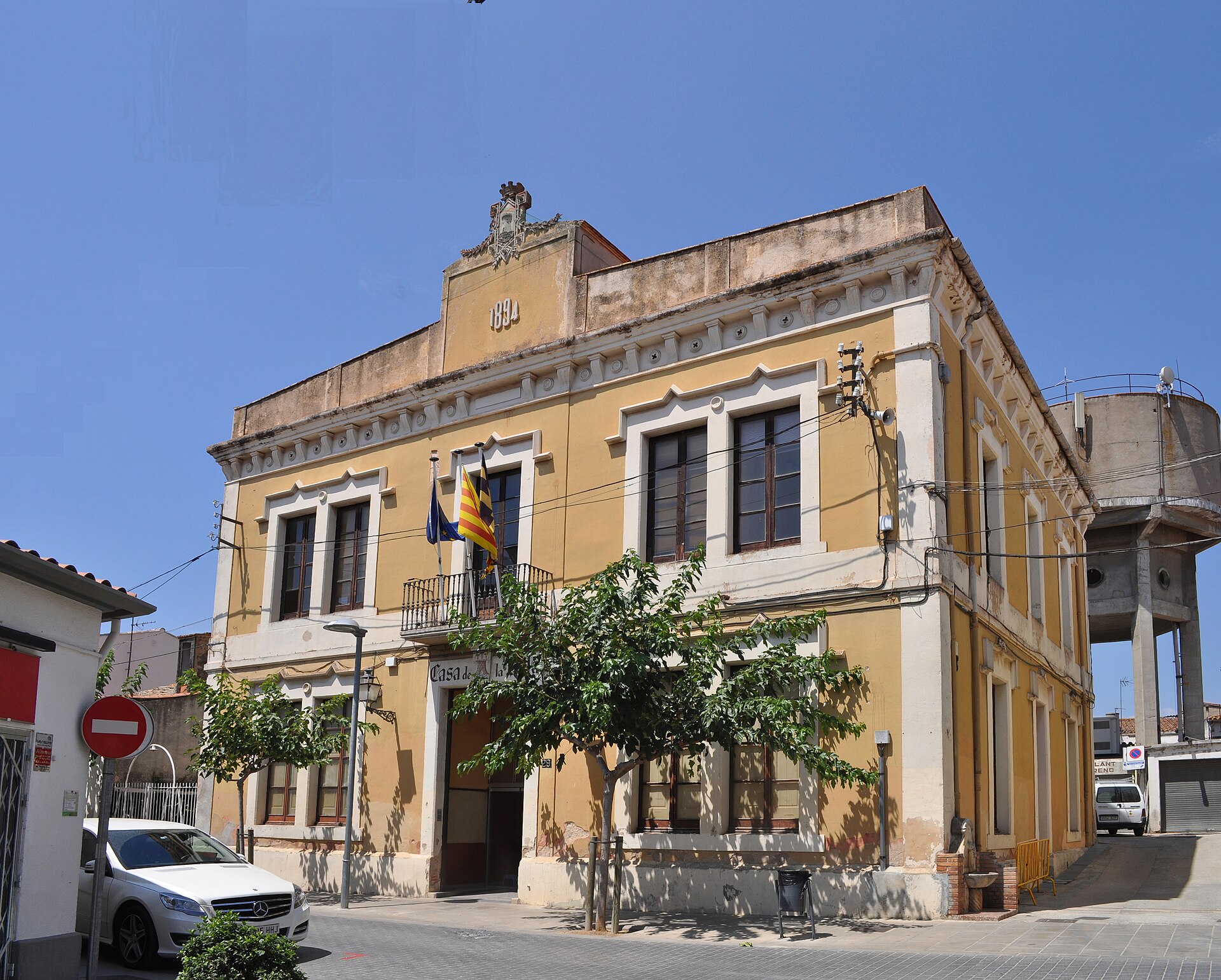
Vidreres town hall stands on Plaça Catalunya in the heart of this small town in Girona province, in Catalonia's La Selva region. Completed in 1894, it has served without interruption as the seat of the local mayor and municipal administration ever since. What does the building look like? The town hall was built in an eclectic style with classical references. Its façade is split into three sections, the central one being the most prominent: it houses the ground-floor main entrance and a distinctive cast-iron balcony one level up, from which the mayor traditionally addresses residents during civic events. Moulded window surrounds add refinement to the elevation without tipping into heavy ornamentation. Inside, the building is organised into three parallel sections divided by load-bearing walls set perpendicular to the street. The ground floor holds a vestibule with a two-arch portico resting on a single column — one arch opens onto the staircase leading up to the "piano nobile," the formal upper floor. That level contains the plenary hall where council sessions are held, the former residence of the town secretary, and a number of administrative offices. Why is it worth a stop? The building is listed as a cultural asset of local interest, recognised as an example of late-19th-century Catalan municipal architecture. Anyone curious about the region's civic history or period architecture will find it a worthwhile short stop while exploring central Vidreres — the square in front of it is a natural gathering point for locals and a good starting point for wandering the rest of the town. How do you get there? The town hall sits at Plaça Catalunya 29, right in the centre of Vidreres, a short drive from the Costa Brava coastline and close to the main roads linking Girona with Lloret de Mar. Reaching the town centre is easiest by car or local bus; once there, the square and surrounding streets are fully walkable, with no need for underground parking or special tourist infrastructure. What else is nearby? The streets around the town hall form a typical Catalan old town, lined with houses and local shops. It's worth pairing a stop at the town hall with a stroll through the surrounding lanes, where the town's historic street layout survives largely intact, and with a visit to the wider natural attractions of the La Selva region on the way toward the Costa Brava. When should you visit? The façade and balcony look best in afternoon light, when the sun falls directly on the square-facing elevation. Since the building remains an active municipal office, its interior — the plenary hall and administrative offices — isn't open to visitors day to day; plan on viewing it from outside unless the town is hosting a public event, such as a local festival, that opens it up. Frequently asked questions Can visitors go inside Vidreres town hall? No — it functions as an active municipal office, so the interior, including the plenary hall and offices, isn't routinely open to the public. The façade and portico can be viewed freely from outside. When was the building constructed? It was completed in 1894, in an eclectic style drawing on classical architectural references. What's the most distinctive architectural feature? The cast-iron balcony on the formal upper floor, and the ground-floor vestibule with its two-arch portico supported on a single column. Is the town hall a protected heritage building? Yes, it's listed as a cultural asset of local interest, valued as an example of late-19th-century Catalan municipal architecture.
-
Labastida town hall
Labastida / Bastida
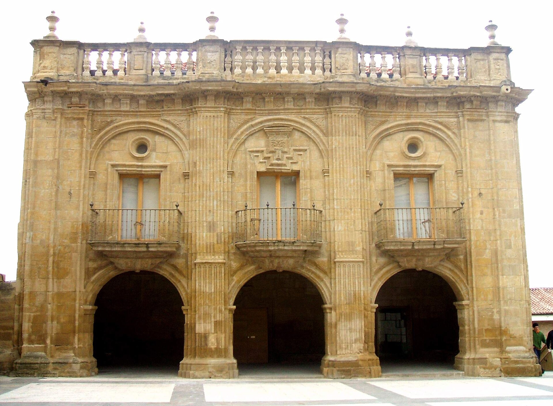
Labastida town hall sits right at the heart of Labastida/Bastida, in the Rioja Alavesa wine region of the Basque Country. What makes the building notable? The town hall was built between 1730 and 1745 out of dressed stone, designed by Agustín de Azcárraga with stonework carried out by Ignacio de Lizarralde. It's a fine example of late Baroque civic architecture, a style local governments favored across 18th-century Spain when town councils built imposing seats to signal regional prosperity. The façade rests on an arcaded portico, giving passersby shelter from sun or rain while doubling as a natural gathering spot on the square. Thanks to its architectural and historical value, the building has been declared a national monument. Where is it and how do you get there? The town hall stands at Plaza de la Paz 1, directly facing the parish church — the easiest landmark to navigate by once you're in town. Labastida sits in the heart of Rioja Alavesa, close to the Ebro river and the Sierra de Toloño range, so arriving by car is the most practical option, since the town connects well to the region's main wine-route roads. The square in front of the town hall works as a natural starting point for exploring the old quarter on foot. What else is worth seeing nearby? Labastida is best known as one of Rioja Alavesa's historic wine-producing towns, so beyond the town hall itself, the surrounding vineyards and wine cellars are well worth a visit. The square sits right next to the parish church, making it a natural launchpad for wandering the old town's layout — narrow lanes, stone houses, and traces of the defensive walls typical of towns in this region. When is the best time to visit? Rioja Alavesa has a continental climate with hot summers and cold winters, so spring and autumn make for the most comfortable sightseeing weather. Autumn also coincides with the grape harvest, adding extra atmosphere to a visit. The square itself is open and accessible year-round, so the town hall's exterior can be enjoyed at any time. Can you go inside? The building still functions as an active municipal office, so visits are generally limited to admiring the façade and portico from outside. The interior isn't set up as a tourist attraction, but the arcaded front alone conveys the building's historical weight. Frequently asked questions When was Labastida town hall built? Construction ran from 1730 to 1745, in late Baroque style, designed by Agustín de Azcárraga. Where exactly is the town hall located? At Plaza de la Paz 1 in Labastida/Bastida, directly opposite the parish church, right in the town center. Does the building have any special protected status? Yes — it has been declared a national monument because of its architectural and historical significance. Is the interior open to visitors? It's still a working municipal office, so most visitors admire it from the square, taking in the arcaded façade rather than touring the inside.
-
Puentedura town hall
Puentedura
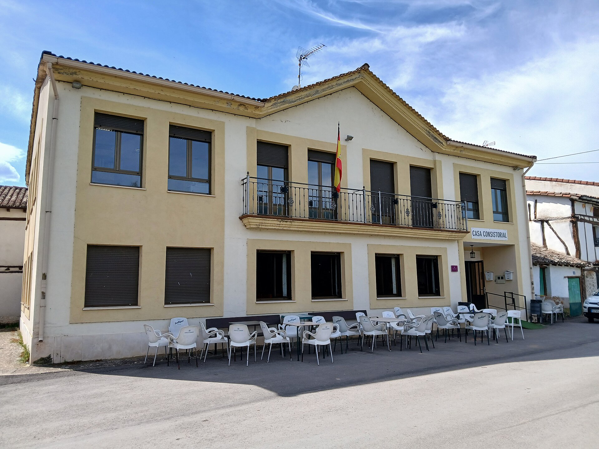
Puentedura town hall sits at the heart of this small village in the province of Burgos, in the Arlanza region of Castile and León. It's easy to drive past without noticing, but the building carries a small, telling piece of local history. What is this building? The town hall dates back to 1798 and follows the plain administrative style typical of the late 18th century in the Arlanza area. Its most distinctive feature is a set of ground-floor arcades — local sources note that underneath them once stood an old forge with a hearth used for shoeing horses. It's a detail that says a lot about how, in small Castilian villages, the seat of local government often shared space with the everyday economic life of the community. Where exactly is Puentedura? Puentedura is a tiny village of around a hundred-odd residents, set on the BU-904 road roughly 15 km from Lerma and 7 km from Covarrubias — two well-known stops on this stretch of Burgos province. The local economy still runs on farming and livestock, with cereal fields dominating the land and orchards of cherry trees that burst into blossom each spring. What else is worth seeing nearby? Pair a look at the town hall with a visit to the nearby Ermita de San Millán, one of the oldest places of worship in this part of the Arlanza valley, its walls decorated with 15th-century murals. Puentedura itself, though small, has the feel of a genuine working Castilian village — quiet, unhurried, and free of crowds, which for many visitors is exactly the point. How do you get to Puentedura? The easiest approach is by car along the BU-904, the road linking Lerma and Covarrubias, both of which connect well to Burgos and make a natural base for exploring the area. Puentedura has little tourist infrastructure of its own — no large car parks or marked trails — so it's best treated as a short stop along the way rather than a standalone destination. When is the best time to visit? Spring and early summer are ideal, when the cherry orchards are in bloom, and early autumn offers milder temperatures than the peak of Castile's continental summer. In winter, the BU-904 can feel bleak, matching the region's cold, dry climate. Frequently asked questions Can you go inside Puentedura's town hall? It's still a working municipal building, so interior access is limited to office hours. The exterior, including the arcades, can be viewed freely at any time. How long does it take to see the village itself? Puentedura is very small — walking through the centre, taking in the town hall and the nearby ermita, usually takes no more than 30 to 45 minutes. Are there places to eat or stay in Puentedura? The village is tiny and farming-focused, so it's better to base yourself in Lerma or Covarrubias, both a short drive away, for restaurants and accommodation. What else should I see between Lerma and Covarrubias? Besides the town hall, it's worth stopping at the Ermita de San Millán with its medieval murals — a modest but rewarding pause on the drive through the Arlanza valley.
-
Fonfría town hall
Fonfría
Fonfría town hall sits at the heart of Fonfría, a village in the province of Zamora, Castile and León. Where exactly is this part of Zamora? Fonfría is both the name of a small village and of the wider municipality it anchors, spread across a plateau between the Aliste and Duero river valleys, in the historic Aliste region in the northwest of Zamora province. The town hall building, standing on the main through-road (postal code 49510), is the seat of local government for the entire municipality, which brings together nine settlements: Fonfría itself, Bermillo de Alba, Castro de Alcañices, Salto de Castro, Brandilanes, Fornillos, Ceadea, Arcillera and Moveros. From here, day-to-day administration is run for a wide but sparsely populated rural district. What kind of place is the Fonfría municipality? The landscape is classic Aliste tableland: open, gently broken by low rises, thinly settled, and shaped by generations of farming and shepherding. Daily life is scattered across the villages that make up the municipality, and the town hall in Fonfría remains the shared administrative anchor for people living across all nine of them. It's a small-scale, unglamorous kind of government building — but a genuinely central one for the surrounding countryside. What is there to see around the town hall? The municipality's southern edge follows the Duero, where the river widens into the Castro reservoir, right on the boundary of the Arribes del Duero Natural Park. Expect deep river canyons, a landscape favored by birdwatchers tracking raptors and by hikers drawn to the cliff-lined banks. Further north lies the Sierra de la Culebra, one of Spain's best-known areas for spotting wild wolves in their natural habitat. Within the municipality itself, the village of Moveros is worth a detour for its centuries-old pottery tradition, still practiced by local craftspeople today. How do you get there, and when should you go? Fonfría sits on a local road linking it to the other villages of the Aliste region, in a quiet stretch of Zamora well off the main tourist routes. A car is the practical way in, and the village makes a sensible base for combining a visit to the Arribes del Duero canyons with a trip further north into the Sierra de la Culebra. Spring and autumn are the most comfortable seasons to explore — summers run dry and hot, while winter can make the higher back roads harder going. Frequently asked questions What is the Fonfría town hall building? It's the seat of local government for the Fonfría municipality, which administers nine villages in the Aliste region of Zamora province. How many villages belong to the Fonfría municipality? Nine: Fonfría, Bermillo de Alba, Castro de Alcañices, Salto de Castro, Brandilanes, Fornillos, Ceadea, Arcillera and Moveros. What's worth seeing near the town hall? The Castro reservoir and the canyons of the Arribes del Duero Natural Park to the south, the Sierra de la Culebra to the north, and the pottery village of Moveros within the municipality itself. Is the area around the town hall a tourist draw? The building itself is a modest administrative office, but the surrounding municipality attracts travelers looking for quiet, wild Zamora landscapes — especially wolf-watchers and hikers.
-
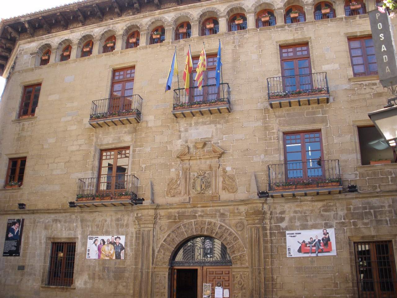
Sos del Rey Católico town hall
Sos del Rey Católico's town hall sits on the Plaza Mayor of this Aragonese hill town and has housed the local council for five centuries. What is the building itself like? The town hall went up in the 16th century as a municipal palace, and it has kept that civic role ever since. Its façade is built from dressed ashlar stone, and the town's coat of arms crowns the heavy wooden entrance doors — an immediate clue that this is a seat of government rather than a private house. The Renaissance lines of the front contrast with the plainer medieval buildings around it, which is worth pausing on before stepping inside. What's worth seeing on the courtyard and inside? Step through the doors and the layout follows the pattern of Renaissance civic palaces: round-arched arcades on columns, rusticated stonework, and coffered ceilings that together give the space a formal, orderly feel. The courtyard floor is paved with a mosaic of river pebbles, a technique once reserved for noble residences, which hints at how much the town's founders wanted this building to impress. Across its three storeys, the decoration leans on garlands, medallions, and crowns that echo fortified architecture, while the top floor is finished with a gallery of small arches — a signature feature of Aragonese palaces from this period. Why does the Plaza Mayor matter as much as the building? The town hall doesn't stand alone; it's the anchor of a square that has served as the town's public, administrative, and commercial heart since the Middle Ages. The same square, also known as Plaza de la Villa, holds two other notable buildings: the former covered market, now the town library, and the 18th-century Isidoro Gil de Jaz school. The oldest surviving piece of the square is the stone arcade where the medieval market once took place — where its arches meet, a groove is still visible marking the "vara aragonesa," the traditional unit of length used across the region until the 19th century. It's a small detail, but it tells you more about everyday medieval life here than the façade alone ever could. How do you get there, and when's the best time to visit? Plaza Mayor sits right at the heart of historic Sos del Rey Católico, in Zaragoza province, within the Cinco Villas district. The town is compact and best explored on foot — leave the car at a parking area near the entrance to the old quarter. Since the town hall is a working administrative building, the interior isn't always open to casual visitors, but the façade, courtyard, and the square itself can be admired year-round. Spring and autumn are the most comfortable seasons, as Aragón's summer heat can be intense. Frequently asked questions How old is the Sos del Rey Católico town hall? The building dates to the 16th century, built as a Renaissance municipal palace that has served as the seat of local government from the start. Can visitors go inside the town hall? Since it remains an active administrative building, interior access is often limited to office hours or occasional events, so it's worth checking locally before planning around it. What else is on the Plaza Mayor? Alongside the town hall, the square holds the former covered market (now the municipal library), the 18th-century Isidoro Gil de Jaz school, and a stone arcade that still bears the mark of an old unit of measurement. Is it worth combining with the rest of the old town? Yes — Plaza Mayor connects directly into the medieval streets of Sos del Rey Católico, so it fits naturally into any walking route through the historic centre.
Earn badges for the places you visit
Download NextOnTrip, discover new places and check off your trails.