Monuments in Spain
A guide to 4655 Monuments in Spain — with descriptions, photos and traveler visits from the NextOnTrip community. Locations spread across 2240 cities and towns. Most visited by the community: castle of Chulilla, Castle of Pioz, castell de la Todolella.
-
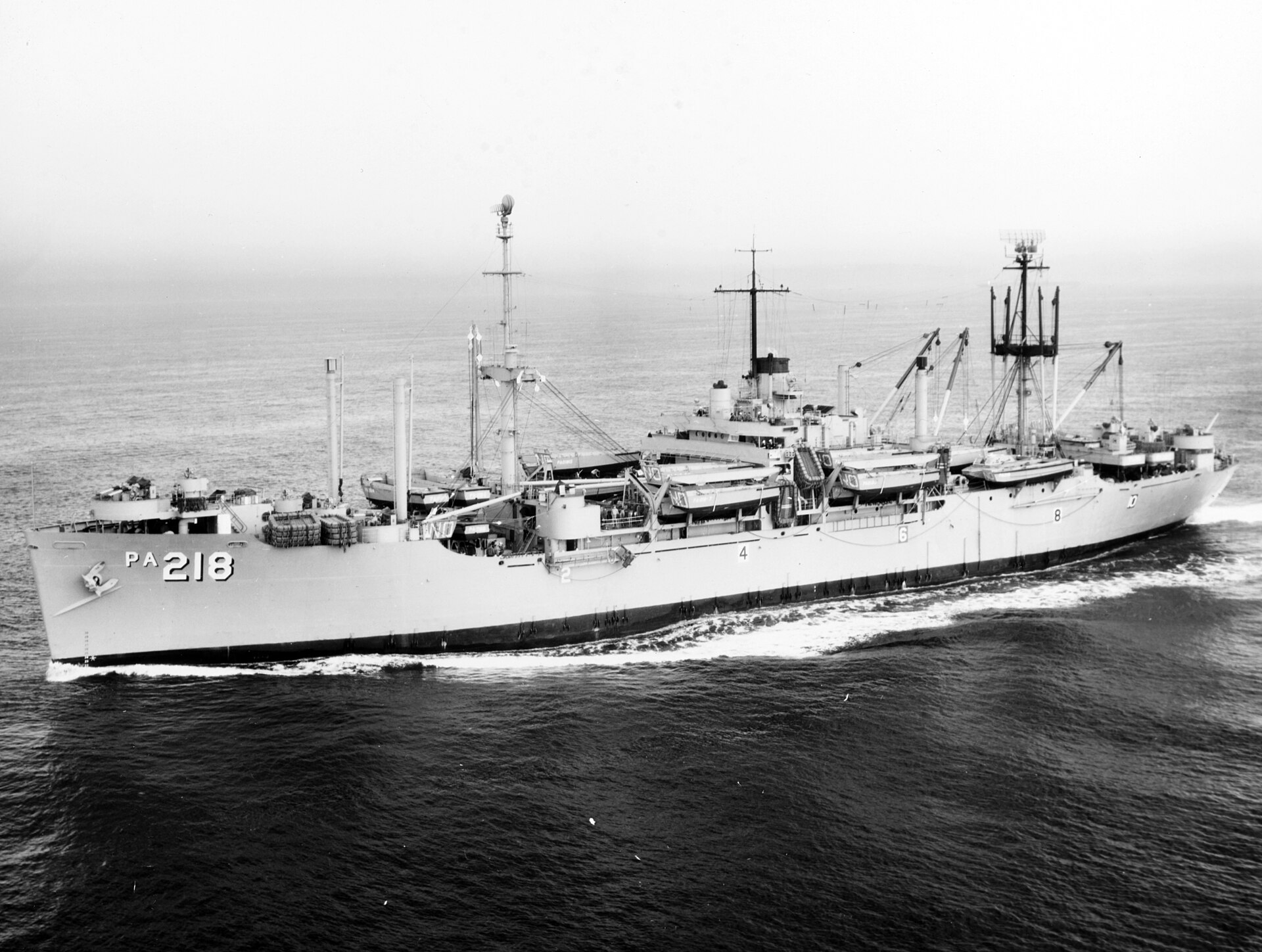
USS Noble
Colmenar Viejo
USS Noble is a memorial anchor standing in Colmenar Viejo, marking the story of a United States Navy vessel that later sailed under the Spanish flag. What Exactly Is This Landmark? The name "USS Noble" actually belongs to two different ships in US Navy history. The first entered service in 1861 and became part of the so-called Stone Fleet, a group of aging sailing vessels deliberately scuttled in 1862 to block Confederate harbor entrances during the American Civil War. The second ship to carry the name, designated APA-218, entered service in 1944 as an attack transport built to carry troops and equipment during amphibious operations in the closing years of World War II. Once its American career ended, APA-218 was not scrapped. In 1964 the US Navy transferred the ship to Spain, where it continued in service under a new name, Aragón, with the hull designation TA-11. The anchor now displayed in Colmenar Viejo comes from this very vessel — a concrete, physical trace of a history that spans two navies and two continents. How Do You Get There? Colmenar Viejo sits in the northern part of the greater Madrid region, connected to the capital by interurban bus lines and the M-607 road. The anchor stands in a public space within the town, so the easiest way to reach it is on foot as part of a walk through the town center, where it forms a natural stop on a route linking other local sites of historical interest. What Will You See? The centerpiece is the ship's metal anchor, set up as an open-air memorial. It is typically accompanied by an information plaque explaining the object's origin and its connection to a vessel that served under both the American and Spanish flags. It is an unusual find: a local memento of a large World War II-era landing transport, displayed far from any coastline, in an inland town of the Madrid region. When Is the Best Time to Visit? Since the anchor stands outdoors and is accessible year-round, there is no season that rules out a visit. Spring and autumn tend to be the most pleasant, when temperatures in the Madrid region are milder than during the peak of summer, making a walk through town more comfortable. Worth Knowing The story of this anchor shows how ships built for one conflict can go on to serve other navies for decades afterward. Attack transports of the type USS Noble belonged to were mass-produced during World War II for amphibious operations across the Pacific and in Europe, and many were later handed over to allied navies once the war ended — as happened here, when the ship continued serving Spain for years under the name Aragón. Frequently Asked Questions What was USS Noble (APA-218)? It was an American attack transport commissioned in 1944 and used to carry troops and equipment during amphibious operations. Why was the ship transferred to Spain? In 1964 the US Navy handed the vessel over to Spain, where it continued in service under the name Aragón, with the hull designation TA-11. Was this the only ship named USS Noble? No. An earlier American ship of the same name existed between 1861 and 1862, serving as part of the Stone Fleet. Is there a fee to see the anchor in Colmenar Viejo? No. As an open-air monument in a public space, it can be visited free of charge at any time.
-
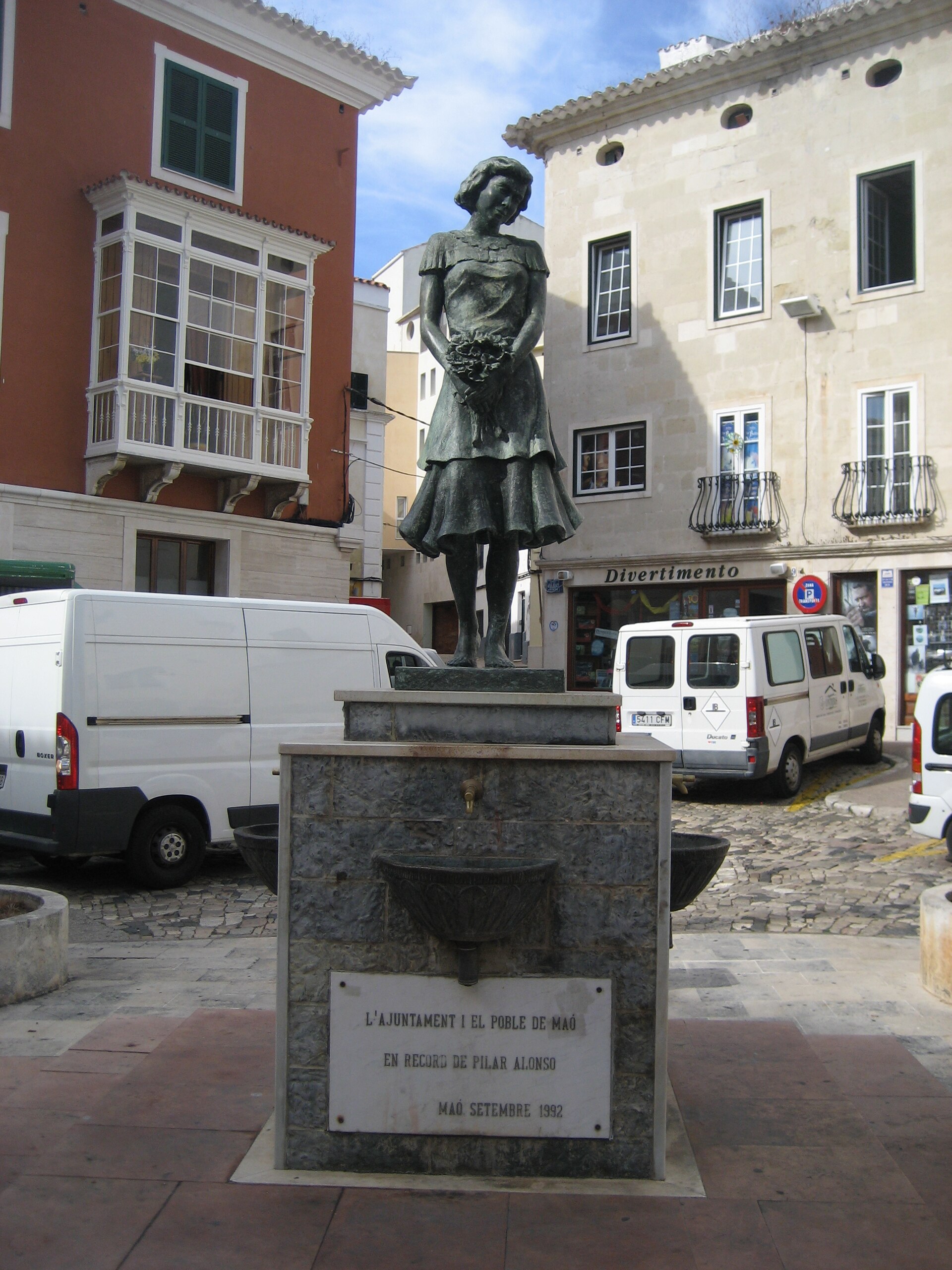
Pilar Alonso i Moll
Maó
The monument to Pilar Alonso i Moll stands in the heart of Maó, the capital of Menorca, honoring one of the most celebrated performers of the Catalan music scene in the early twentieth century. Who was Pilar Alonso i Moll? Pilar Alonso was born in Maó on 15 February 1897 into a working family — her father was a barber who also played clarinet in the local orchestra, while her mother ran a hairdressing salon. It was in that very salon, at the age of twelve, that Pilar began singing popular cuplets for the customers. Her turning point came in 1913, when she watched the famous Raquel Meller perform at the Teatre Principal in Maó; from then on, locals nicknamed her "the little Raquel." She made her stage debut at fifteen in Mallorca, then moved with her father to Barcelona, where she first performed at the Teatro Eldorado in 1917. Between 1919 and 1925, at the peak of her career, she took the stage at the prestigious Teatre Tívoli and Teatre Lara, and record labels of the era captured her voice on 129 sides across 64 records. She helped popularize Catalan cuplets such as "Remena, nena," "El vestit d'en Pasqual" and "La Marieta de l'ull viu." She retired from performing in 1926 to get married and never returned to the stage. She died in Madrid on 27 May 1980. Where is the monument located? The sculpture dedicated to the singer was unveiled in 1992 on Plaça Colón in Maó, as part of the city's walking route through the historic center. The square sits just a few minutes on foot from the harbor and the main shopping streets, making it an easy stop to fold into any stroll through the old town. What can you see there? The monument was created by sculptor Francesc Vilà. Its composition evokes the singer's figure in stage costume, reminding passers-by of an era when cuplet performances were among the most popular forms of entertainment in Barcelona and across the Balearic Islands. It's worth pausing here for a moment and linking the visit with the rest of the heritage trail through Maó's historic center, since several other stops on the same walking route lie nearby. When is the best time to visit? The square is open year-round, at any hour, with no entry fees or restrictions. Early morning or late afternoon are the most pleasant times to walk through, when the sun is gentler and the town center is quieter than during peak season (July–August). In autumn and spring, Maó tends to be calmer overall, making it easier to photograph the monument and the surrounding architecture without crowds. Frequently Asked Questions Who was Pilar Alonso i Moll? A Menorcan-born singer of Catalan cuplet, regarded as one of the genre's leading performers between 1919 and 1925. Where exactly is the monument? On Plaça Colón in the center of Maó, part of the city's heritage walking route. Who created the monument and when? The sculpture is the work of Francesc Vilà, unveiled in 1992. Is there a fee to visit? No, the square is freely accessible at all times.
-
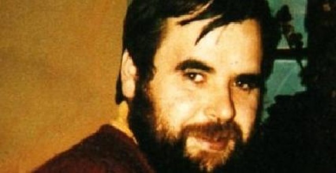
Mikel Zabaltza Garate
San Sebastián
Mikel Zabaltza Garate is a name tied to San Sebastián that commemorates a Basque bus driver whose death in 1985 became one of the most disturbing symbols of political repression in the Basque Country. The place associated with his name gives visitors a window into a difficult chapter of the city's and the region's recent history. Who was Mikel Zabaltza Garate? Mikel Zabaltza Garate (also written as Mikel Zabalza Garate) worked as a driver for San Sebastián's municipal transport service, operating the city's trolleybuses. He was an ordinary resident of the city until 1985, when he was taken into custody by the Spanish Civil Guard. Shortly afterward, his body was found in the Bidasoa River, which marks the border between Spain and France in the Basque Country, a short distance east of San Sebastián. What happened in 1985? For decades, the official account of his death was disputed by Basque human rights groups. It took 35 years of inaction by the Spanish judicial system before it was finally established that Zabaltza died as a result of torture inflicted by Civil Guard officers at the Intxaurrondo barracks, a facility located within San Sebastián itself. It was there that he was held and interrogated before his body ended up in the river. Why does San Sebastián remember this story? The case of Mikel Zabaltza Garate has become one of the symbols of the long struggle to bring state violence against Basque citizens during Spain's political transition to light. Decades of institutional silence, and the lack of accountability for those responsible, mean that his name today serves as a reference point in San Sebastián's ongoing conversation about historical memory. For residents of the Basque Country, this is not distant history — the Intxaurrondo barracks still stand in the city, and Zabaltza's name remains part of the local identity and the debate over reckoning with the past. When and how to visit this memory site? San Sebastián is easy to reach: the city has its own airport, good rail connections to Madrid, Barcelona, and France, and the Intxaurrondo district lies just a few kilometres from the centre, reachable by city bus. Visitors interested in the history of political repression in the Basque Country can treat this place as a complement to the city's better-known attractions, alongside its beaches and old-town landmarks. It's worth visiting at a quieter moment, suited to reflection rather than a rushed sightseeing pace — this is a place of a different character than San Sebastián's typical tourist stops. Frequently asked questions Who was Mikel Zabaltza Garate? A Basque bus (trolleybus) driver employed by San Sebastián's municipal transport service, detained by the Civil Guard in 1985. How did Mikel Zabaltza Garate die? He died as a result of torture inflicted by Civil Guard officers at the Intxaurrondo barracks in San Sebastián, a fact confirmed only after 35 years of investigation. Where was Zabaltza's body found? In the Bidasoa River, which marks the Spanish-French border in the Basque Country, near San Sebastián. Why does this story matter to San Sebastián? It symbolises the struggle to expose state violence against Basque citizens and remains a significant part of the city's historical memory.
-
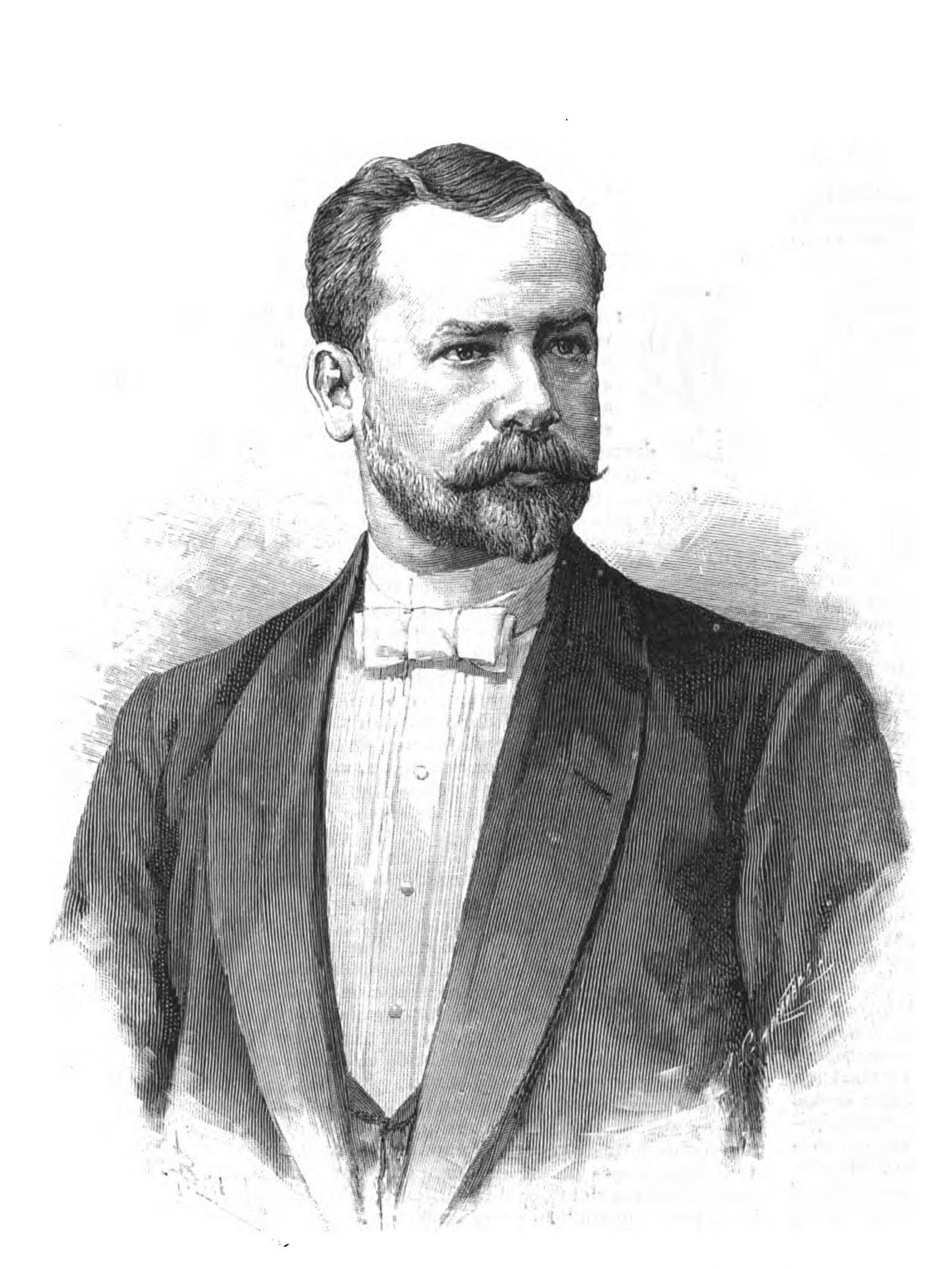
Saturnino Calleja
Burgos
Saturnino Calleja is a site in Burgos honoring one of the city's most notable native sons — a publisher, educator, and writer who changed the way Spanish children learned to read at the turn of the 20th century. Who was Saturnino Calleja? Saturnino Calleja Fernández was born in Burgos on February 11, 1853, and died in Madrid on July 7, 1915. In 1879 he bought the small bookshop and bookbinding business his father had founded in 1876 on Calle de la Paz in Madrid, and turned it into Editorial Calleja — a publishing house that quickly became one of the most popular in Spain. Calleja brought two genuine innovations to Spanish publishing. First, he printed enormous runs of books and stories on thin margins, driving prices down far enough that families of modest means could afford them. Second, he commissioned lavish illustrations from the best artists of the era, turning his editions into visually appealing stories that pulled generation after generation of children into reading. Thanks largely to him, the cheap, illustrated children's book stopped being a luxury in Spain and became a household staple. Why does his name still live on in everyday Spanish? Calleja's publishing work left a lasting mark on the Spanish language itself. The expression "tienes más cuento que Calleja" — literally "you've got more stories than Calleja" — is still used today to describe someone who exaggerates or spins tall tales, and it traces directly back to the sheer volume of stories and fairy tales his house published in the 19th century. Burgos takes visible pride in the fact that the man behind this everyday phrase was born within its walls. What should you know before visiting? The site dedicated to Calleja in Burgos marks a point in the city where his biography and his contribution to Spain's reading culture are commemorated. It's a good starting point for learning about a man who built his publishing career in Madrid yet never lost his ties to his hometown. The story continues at a museum dedicated to Calleja that opened in 2022 in Quintanadueñas, a town in Burgos province, housed in the same building as the local public library — worth combining with a visit here if you're tracing the publisher's legacy. How to get there and when to visit? The site sits within Burgos, a city well connected by train and bus to Madrid, Valladolid, and Bilbao, which makes it easy to fit into a day trip or a longer itinerary through Castile and León. Spring and early autumn are the best times to visit, when temperatures are milder than in the height of summer and walking through Burgos's historic center is at its most pleasant. Frequently asked questions Who was Saturnino Calleja? A publisher, educator, and writer born in Burgos in 1853, founder of Editorial Calleja, the publishing house that made cheap, illustrated children's books widely available across Spain. Where does the popular saying tied to his name come from? It comes from the huge volume of stories his publishing house released in the 19th century, giving rise to "tienes más cuento que Calleja," still used today for someone prone to exaggeration. Can you learn more about his life in Burgos? Yes — the city commemorates its famous native son, and nearby Quintanadueñas has hosted a museum dedicated to his life and publishing legacy since 2022. What's the best way to plan a visit? Pair it with a walk through Burgos's historic center and, time permitting, a side trip to Quintanadueñas to see the museum devoted to Calleja.
-
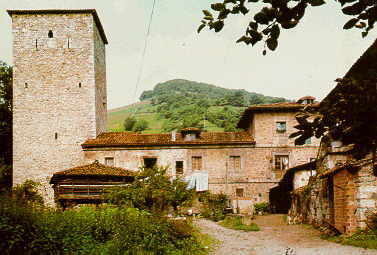
Palace of Villanueva
Grau / Grado
The Palace of Villanueva stands in Grado (Grau in Asturian), a town in the historic region of Asturias in northwestern Spain. The complex brings together a medieval defensive tower, a chapel, and a palace wing added in later centuries, forming one of the region's notable examples of noble residential architecture. What is the story behind this building? The oldest part of the ensemble is a stone tower dating back to the 15th century, originally built as part of a feudal stronghold that belonged to the counts of Coalla. The palace itself came later, in the 16th century, commissioned by a branch of the Valdés family — specifically María Alonso de Quirós and Andrés Díaz de Villanueva, who established the Villanueva entailed estate (mayorazgo) and founded the residence on that basis. During the 18th century, further wings were added next to the old tower, and together these additions are now generally referred to as "El Palacio." Ownership shifted over the generations: in the 19th century the estate belonged to the Marquis of San Esteban del Mar, later passing into the hands of the Counts of Revillagigedo. What will you see on site? The tower is square in plan, roughly 7.5 meters per side, originally rising through five floors to a total height of about 20 meters. It still displays typical defensive features of medieval military architecture, including loopholes and machicolations — projecting galleries once used to defend the base of the wall. The palace itself follows a roughly square layout, organized into three sections around an inner courtyard shifted toward the north side. The walls were built using rubble masonry, while the corners and window and door openings were finished in ashlar stone, giving the façades a rugged yet precise character typical of Asturian residential architecture. It's worth knowing before you go that the building is currently in a notably neglected state. This isn't a fully restored tourist attraction with visitor infrastructure — it's an authentic, partly abandoned monument that nonetheless still impresses through its silhouette and layered history. How do you get there? The palace sits within the municipality of Grado, in central Asturias, close to the Nalón river. Grado is well connected by road to Oviedo, the regional capital, making it a convenient base for exploring central Asturias. Given the building's current condition, the best way to experience it is from the outside — the tower and palace make an impression even viewed from a distance. When is the best time to visit? Spring and early autumn are the most pleasant seasons to explore the area, offering mild temperatures and less rainfall than winter. Summer can also be enjoyable, though it tends to bring more visitors to the Asturian coast nearby. It's worth pairing a stop at the palace with a visit to other historic sites in Grado and the surrounding villages. Frequently asked questions Can you visit the inside of the palace? Because of its poor state of conservation, the building is not regularly open for interior visits — check with the local town hall for current access information before planning a trip. How old is the palace's tower? The tower dates from the 15th century and is a remnant of an earlier feudal stronghold, predating the palace itself, which was added in the 16th century. Is the site officially protected as heritage? Yes, the complex is listed as a Bien de Interés Cultural (Asset of Cultural Interest) under the Monument category in Spain's heritage register. How do you reach Grado from Oviedo? Grado lies a short distance from Oviedo and is well served by road, making the drive under half an hour by car.
-
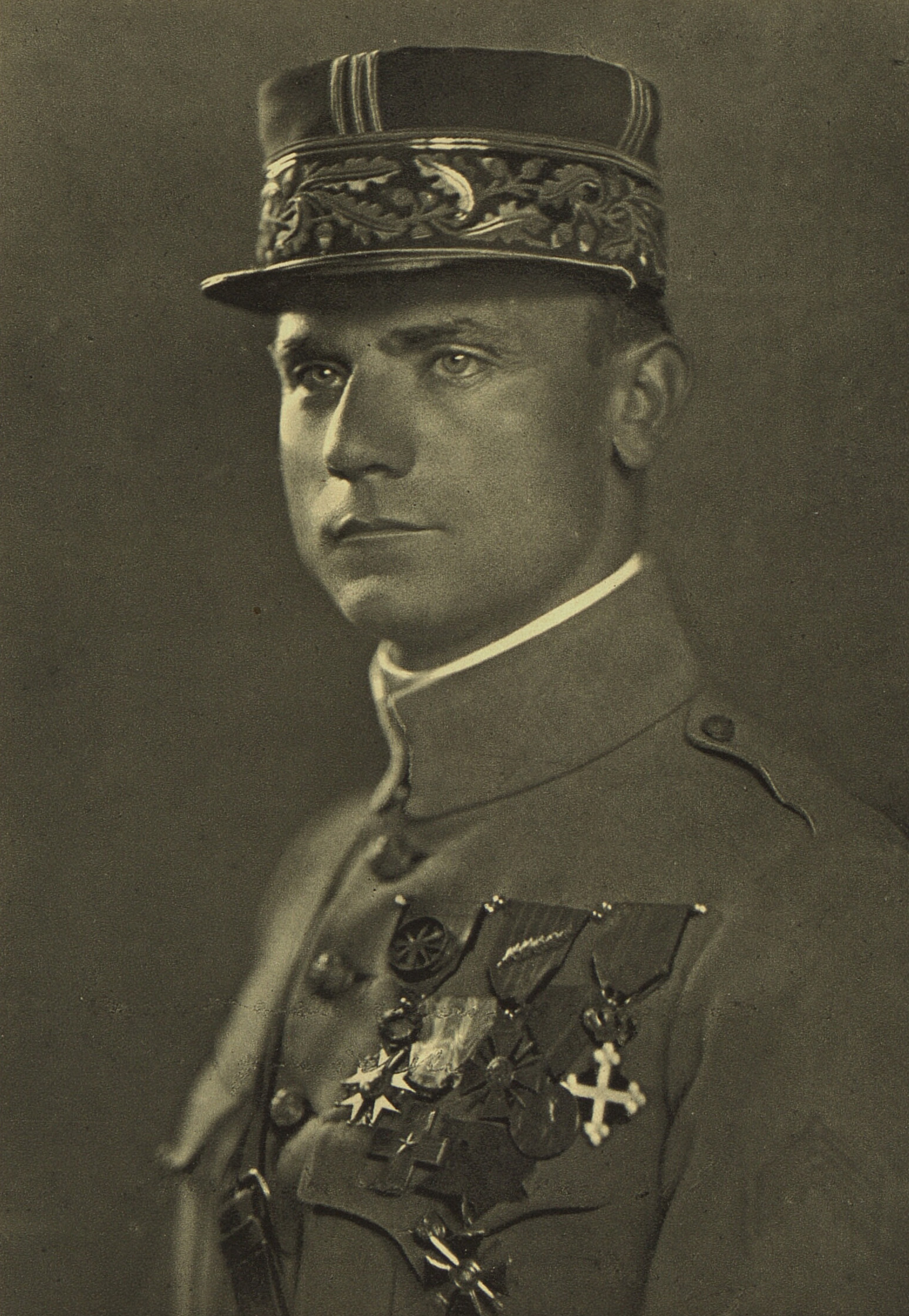
Milan Rastislav Štefánik
Alcossebre
The Milan Rastislav Štefánik Monument stands on the seafront promenade of Alcossebre, a small coastal town on the Costa del Azahar in the province of Castellón. It is the only monument in Spain dedicated to this Slovak astronomer, diplomat and general, and its presence in this particular spot is no accident of geography — there's a concrete historical reason behind it. Why is there a monument to a Slovak general in Alcossebre? Before becoming one of the founding figures of independent Czechoslovakia, Milan Rastislav Štefánik was a working astronomer. In 1905 he joined an official French scientific expedition set up to observe and record a total solar eclipse. The team chose the coastline near Alcossebre as its observation point, drawn by the area's favorable geography and reliably clear skies. Taking part in that expedition earned the young scientist recognition within French astronomical circles and helped launch the career that would later carry him into politics and military life. Who was Milan Rastislav Štefánik? Born in 1880 and killed in a plane crash in 1919, Štefánik held two roles at once during the First World War: general in the French Army and Minister of War for the Czechoslovak government. As one of the leading members of the Czechoslovak National Council, he had a direct hand in resolving the fate of the Czech- and Slovak-populated territories after the collapse of Austria-Hungary in 1918. In Slovakia he is remembered as a national hero — his image appears on monuments, coins, and street names across the country. His personal motto was "To Believe, To Love, To Work." What will you see on site? The monument sits directly on Alcossebre's seafront promenade, making it an easy stop during an ordinary walk along the shore. It's a modest but meaningful landmark in an otherwise typical holiday town — worth pausing at if you have any interest in Central European history or the history of astronomy. The plaque commemorates a scientific expedition from over a century ago and the man who later played a key role in the birth of a new European state. How do you get there? Alcossebre lies on the Costa del Azahar coastline, between Peñíscola and Oropesa del Mar. The promenade where the monument stands is part of the town's main seafront walkway, reachable on foot from most of the nearby hotels and apartments. It makes a natural stop on a walk connecting the beach, the harbour and the town centre. When is the best time to visit? Since the monument sits outdoors on an open promenade, it's most comfortable to visit outside the peak midday summer heat — early morning or evening, when a walk along the sea is more pleasant. Outside the high tourist season (autumn and spring), the area is quiet and better suited to unhurried sightseeing. Frequently asked questions Why is there a monument to a Slovak general specifically in Alcossebre? Because in 1905 Štefánik took part in a French expedition that came here to observe a total solar eclipse — the only documented, direct link between him and Spain. Is this the only Štefánik monument in Spain? Yes, according to available sources it's the only monument dedicated to him anywhere in the country. What was Milan Rastislav Štefánik's profession? He trained as an astronomer and later became a diplomat and French Army general; he is regarded as one of the co-founders of Czechoslovakia. Is it worth detouring to see this monument? If you're already walking Alcossebre's promenade, the monument is literally on the way — a small but interesting stop linking the history of astronomy with Central European history.
-
Mário Beirão
Beja
Busto de Mário Beirão is a small, quiet monument in Beja, in Portugal's Alentejo region, honoring a poet who was born in the city. Who was Mário Beirão? Mário Pires Gomes Beirão was born in Beja on 1 May 1890 and died in Lisbon in February 1965. He studied law at the University of Lisbon, where his classmates included the poet Florbela Espanca and Américo Durão. He contributed to the literary magazine "Águia" and to the journal "Portucale," and his poetry collections were published by Renascença Portuguesa, including "Cintra," "O Último Lusíada," "Ausente," "Lusitania," and "Pastorais." During the Estado Novo period he also wrote the anthem and march of Mocidade Portuguesa, the Portuguese state youth organization - a detail that ties his biography to the wider political history of 20th-century Portugal. What will you see at the monument? The poet's bust rests on a pedestal engraved with lines from his own poem dedicated to Beja Castle. The verses are steeped in longing - the Portuguese "saudade" - and in the wish to be remembered by his hometown even after death. The monument itself is modest in scale, but its inscription and setting make it one of those easy-to-miss spots that says a great deal about the bond between a writer and the place he came from. How do you get there? The monument stands in Largo Doutor Lima Faleiro, right in the historic heart of Beja and next to the castle walls. It's an easy stop on foot: from the main square, Praça da República, it's only a few minutes' walk through the narrow streets of the old town. Beja's bus station is also within comfortable walking distance. If you're driving, park near the fortified walls and continue on foot, since the old center has restricted traffic. When should you visit? The bust can be seen year-round, since it stands in an open public space. Spring (March-May) and early autumn (September-October) are the most pleasant times to explore this part of Beja, as temperatures are milder than during the peak of summer, when the Alentejo heat can be intense. Early morning or late afternoon light also works well for photographing the stone carving and the inscribed verses. Why is it worth a stop? This is a place where literary history meets local history. Beja honors its poet beyond the monument itself - a school (Escola Básica Mário Beirão) and a street (Rua Mário Beirão) both carry his name. For visitors interested in 20th-century Portuguese poetry or in how a small city remembers its own, the bust is a natural stop on a walk through the castle district, easy to pair with a visit to Beja Castle and its keep. Frequently asked questions Where exactly is the Mário Beirão monument located? In Largo Doutor Lima Faleiro in Beja, right next to the city's castle walls. Who was Mário Beirão? A Portuguese poet born in Beja in 1890, associated with the literary circle around the magazine "Águia" and author of collections such as "Cintra" and "Lusitania." What is written on the pedestal? Lines from his poem dedicated to Beja Castle, expressing longing and asking his hometown to remember him. How long does a visit take? The monument itself takes only a few minutes to see, but it pairs naturally with a visit to nearby Beja Castle, which adds about an hour to the plan.
-
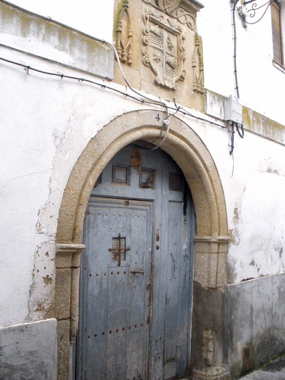
Cárcel Eclesiástica, Coria
Coria
The Cárcel Eclesiástica in Coria is an 18th-century former ecclesiastical prison tucked away on Calle Oscura, one of the narrow shaded streets of the town's old quarter. It's easy to walk past without noticing it, yet the building tells a distinctive story about the judicial power once held by the bishops of Coria and how the Church policed its own within this corner of Extremadura. What was an ecclesiastical prison? For centuries, the Diocese of Coria held its own judicial authority separate from civil courts. Clergy and others who fell under canon law and committed offenses weren't sent to the town's regular jail — they were held instead in a dedicated ecclesiastical prison, a building where, as local tradition puts it, "lack of faith" and breaches of church discipline were atoned for. Who built it, and when? The prison was commissioned by Juan José García Álvaro, Bishop of the Diocese of Coria from 1750 to 1783, remembered locally as a generous patron of building works across the town. Construction is dated to 1760. Historians note it may have been rebuilt on the site of earlier ecclesiastical prisons, since the practice of holding clergy in a separate lockup in Coria likely predates this particular structure — the 18th-century building may simply be the latest version of a function the site had served for some time. What does the building look like today? The Cárcel Eclesiástica stands on the narrow Calle Oscura — literally "Dark Street," a name that fits the shadowed character of this part of the old town. The building rises over two floors, whitewashed on the outside in the manner typical of Extremaduran architecture of the period. Stone is used sparingly and only where it matters structurally or visually: on pilasters, corners, window and door surrounds, the entablature, and the entrance. The entrance is the building's clear focal point — an oversized semi-circular arch cut in fine ashlar masonry. Above it sits the coat of arms of its patron, Bishop García Alvarado, together with the date of construction, which is how historians have been able to tie the building precisely to this bishop and this year. The façade has been altered significantly over the centuries, but it still preserves enough of its original fabric to reveal the Baroque character of the 18th-century design. Can you visit inside? The building survives today mainly as a piece of the town's historic streetscape — its exterior, with the arched portal, coat of arms and whitewashed walls, is the main reason to seek it out on a walk through Coria's old center. It sits well within a walking route that also takes in the cathedral and the nearby Museo de la Cárcel Real (Royal Prison Museum), which is easy to confuse with this building because of the similar name but is, in fact, a separate site with a different history and purpose. Frequently asked questions What's the difference between the Cárcel Eclesiástica and the Cárcel Real in Coria? They are two distinct buildings. The Cárcel Real (Royal Prison) fell under civil authority and today operates as a town museum. The Cárcel Eclesiástica answered to the bishop and the diocese, and was reserved for cases under canon law. When was the building constructed? It is attributed to Bishop Juan José García Álvaro, with construction dated to 1760 — a date recorded in the inscription beneath the coat of arms above the entrance. Where exactly is it located? On Calle Oscura, within Coria's historic center, a short walk from the cathedral and the town walls. Can you go inside the building? The main draw is the exterior architecture — the arched portal, the coat of arms, and the whitewashed façade — rather than an interior visit, since the building does not operate as a museum.
-
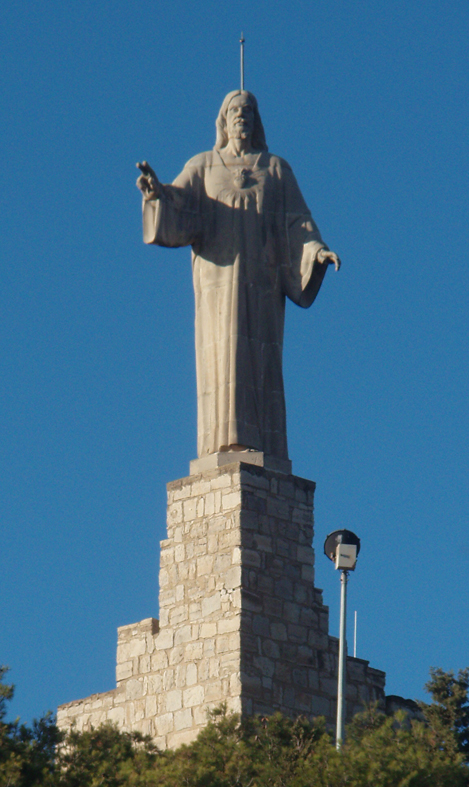
Monumento al Corazón de Jesús
Tudela
The Monument to the Sacred Heart of Jesus crowns Santa Bárbara hill above Tudela, and its silhouette is one of the town's most recognizable landmarks, visible across much of the Ribera region of Navarre. Where does it stand? The statue rises on Santa Bárbara hill, also known as Cerro del Castillo, on the eastern edge of Tudela at the top of Paseo del Castillo. The spot has a history that predates the monument by centuries: it once held the keep of the medieval castle built by Sancho VII "the Strong," king of Navarre, and later a small hermitage dedicated to Santa Bárbara. Remnants of the old fortress walls still form part of the base the monument now rests on. Who built it? The figure of Christ was sculpted by the Italian artist J. Buzzi, while the overall architectural design came from Víctor Eusa, an architect from Pamplona. The statue stands atop a tall, truncated obelisk-shaped pedestal; together, statue and base reach roughly 21 metres, with the figure itself measuring about 12 metres. Construction was paid for through public subscription — donations from the people of Tudela and the surrounding villages of the Ribera — and the monument was formally inaugurated in 1942, on the feast of Christ the King, when crowds walked in procession from the cathedral up to the foot of the statue. Its exposed position on the hilltop has made it a frequent target for lightning strikes, and documented repairs followed strikes in 1971, 1986 and 2000. Despite this, the monument has remained a fixture of the Tudela skyline ever since. How do you get there? Santa Bárbara hill is within walking distance of Tudela's old town. Follow Paseo del Castillo and continue up the path to the summit; the climb is short but fairly steep, so comfortable footwear helps. There is no entry fee and no fixed opening hours — the viewpoint is open to visitors throughout the day. What will you see from the top? The hill is above all a superb viewpoint. Looking toward the city, you get a sweeping view of Tudela, with the cathedral tower and the rooftops of the old Jewish quarter in the foreground, the Monreal tower further off, and the twin monument to the Sacred Heart of Mary visible on the opposite side of town. Turn around, and the view opens onto the Ebro valley, the orchards of La Mejana, and, on a clear day, the eroded badlands of the Bardenas Reales in the distance. When is the best time to visit? Early morning or late afternoon give the softest light over the Ebro valley and help you avoid the sharpest heat of a Ribera summer. In the evening, locals often head up to watch the sunset over the city from the same spot. Frequently asked questions Is there an entrance fee? No. Access to the monument and viewpoint is free and available throughout the day. Who designed the monument? The statue is the work of Italian sculptor J. Buzzi, with the architectural project designed by Víctor Eusa of Pamplona. Why has the statue needed repeated repairs? Its exposed hilltop position has made it a repeated target for lightning strikes, with documented restoration work carried out in 1971, 1986 and 2000. Is there anything else worth seeing nearby? Yes — from the viewpoint you can spot the twin Monument to the Sacred Heart of Mary across town, as well as wide views over the Bardenas Reales and the Ebro valley.
-
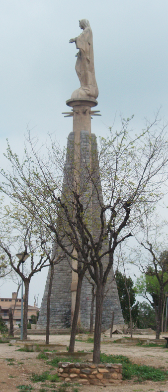
Monumento al Corazón de María
Tudela
Monumento al Corazón de María is a large Marian monument standing on a hill above Tudela, in the Navarre region of Spain. A statue of the Virgin Mary set atop a slender, truncated conical obelisk forms a structure reaching 21.5 meters in height, making it one of the landmarks visible from many points across the Ebro valley below. Where exactly is it located? The monument sits on a hillside directly facing Torre Monreal, close to the Lourdes neighborhood. The elevated position offers wide views over Tudela's old town and the surrounding farmland, so the walk up to the monument is already part of the experience. What is the history behind it? The foundation stone was laid on December 8, 1954, and the monument was formally inaugurated on October 7, 1956. It was built in the middle of the 20th century as an expression of local religious devotion and has remained a fixed part of the city's skyline ever since. Is this the only monument of its kind in Tudela? No — the Heart of Mary has a counterpart on the opposite side of the city: the Monumento al Corazón de Jesús, standing on the Santa Bárbara hill. The two monuments face each other from opposing hills, a layout that reflects a devotional tradition common in Spain during the first half of the 20th century. What will you see on site? The statue itself, perched on a narrow, tapering conical base, is striking even from a distance, its silhouette clearly outlined against the sky. Up close, it's worth noting the proportions of the structure and how it sits within the dry, rocky landscape typical of the area around Tudela. Locals use the hill for walks, and visitors treat it as a natural viewpoint over the city. How do you get there? The hill is within walking distance or a short drive from central Tudela, near the Lourdes district. Because the approach involves climbing, comfortable footwear is recommended, especially in summer when the area can get quite sunny and exposed. When is the best time to visit? Early morning or late afternoon are the best times, when the light flatters the obelisk and the views over the city, and the heat typical of the Ebro valley is more bearable. Spring and autumn bring milder temperatures, making them good seasons for longer walks around the surrounding hills. Frequently asked questions How tall is the monument? The statue of the Virgin Mary together with its conical base reaches a total height of 21.5 meters. When was it built? Construction began with the laying of the foundation stone on December 8, 1954, and the monument was inaugurated on October 7, 1956. Is there a similar monument in Tudela? Yes, the Monumento al Corazón de Jesús stands on the Santa Bárbara hill on the other side of the city, forming a visual pair with this monument. What can you see from the site? The viewpoint by the monument overlooks Tudela's old town and the surrounding farmland of the Ebro valley.
-
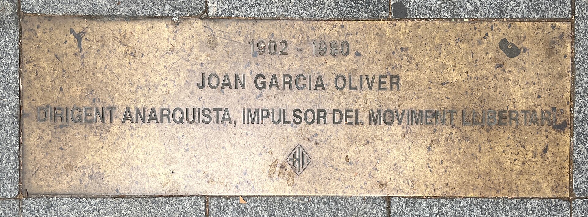
plaque to Joan García Oliver
Barcelona
The memorial plaque to Joan García Oliver stands on Rambla del Poblenou in Barcelona, one of a set of brass plaques making up the Passeig de la Memòria — a memory trail dedicated to figures tied to the Sant Martí district. Who was Joan García Oliver? Joan García Oliver (1902–1980) was born in Reus, but it was Poblenou where he built his political life — he lived on Carrer Espronceda and belonged to the neighborhood's CNT Confederal Defense Committee. He was one of the most charismatic figures of Catalan anarcho-syndicalism: together with Buenaventura Durruti and Francisco Ascaso he founded the group Els Solidaris (Los Solidarios), and later the affinity nucleus known as "Nosotros" (or "los sin nombre"). That group played a central role in organizing the resistance that defeated the military uprising on the streets of Barcelona on 19–20 July 1936. Why does he appear on Poblenou's memory trail? The Passeig de la Memòria was created on the initiative of the Poblenou Neighbors' Association and the Historical Archive of Poblenou, which have been placing plaques across the district since 1999 to honor people who were born, lived, or worked there. The list of honorees remains open to new additions. García Oliver was included because of his local ties and his role in the district's union movement, not because he was born there. Each plaque measures roughly 30 cm by 1.2 meters and carries a short biographical note. The originals were bronze, but in February 2018 the plaques were stolen from the street — most were replaced in 2019, with the final three reinstalled in summer 2020, this time in brass and fitted with anti-theft anchoring. What role did he play in Spanish history? After the July 1936 victory, García Oliver joined the Republican government of Francisco Largo Caballero, taking over the Ministry of Justice on 4 November 1936 — one of four CNT-FAI anarchists to hold ministerial posts for the first time in the movement's history. In just under 191 days in office, he dismantled the old property registry system, annulled all pre-war criminal convictions on 10 November 1936, and appointed Melchor Rodríguez as director of prisons specifically to curb extrajudicial killings. He lost his ministerial post in May 1937, stepping down alongside the other CNT ministers after the so-called May Events in Barcelona. Following the Republic's defeat in 1939 he went into exile — first to France, then to Venezuela and Mexico, where he spent the rest of his life and wrote his memoirs, "El eco de los pasos" (The Echo of Footsteps). How to get there and what else to see nearby Rambla del Poblenou is the district's main promenade, easily reached from Poblenou or Llacuna metro stations on line L4. The García Oliver plaque is one stop along a trail worth walking in full, since it traces the history of working-class and anarchist Poblenou during the Republic, when the CNT was the majority union in the area's factories and workshops. Late afternoon is a good time to walk it, when the rambla fills with the neighborhood's café-and-shop rhythm; from there it's an easy continuation on foot to Poblenou beach, just a few hundred meters away. Frequently asked questions Where exactly is the plaque located? On Rambla del Poblenou, as part of the Passeig de la Memòria trail that runs through the heart of the Sant Martí district. Was García Oliver born in Poblenou? No — he was born in Reus, but he lived in Poblenou and was active in the local CNT Defense Committee, which is why he is honored on this trail. What is he best known for? As a co-founder of Los Solidarios/Nosotros and a key figure in the defense of Barcelona in July 1936, and later as Minister of Justice in the Republican government (1936–1937). Is this the original 1999 plaque? Not necessarily — several plaques along the trail, this one likely among them, were replaced after a theft in 2018; the current pieces are brass and better secured against theft.
-
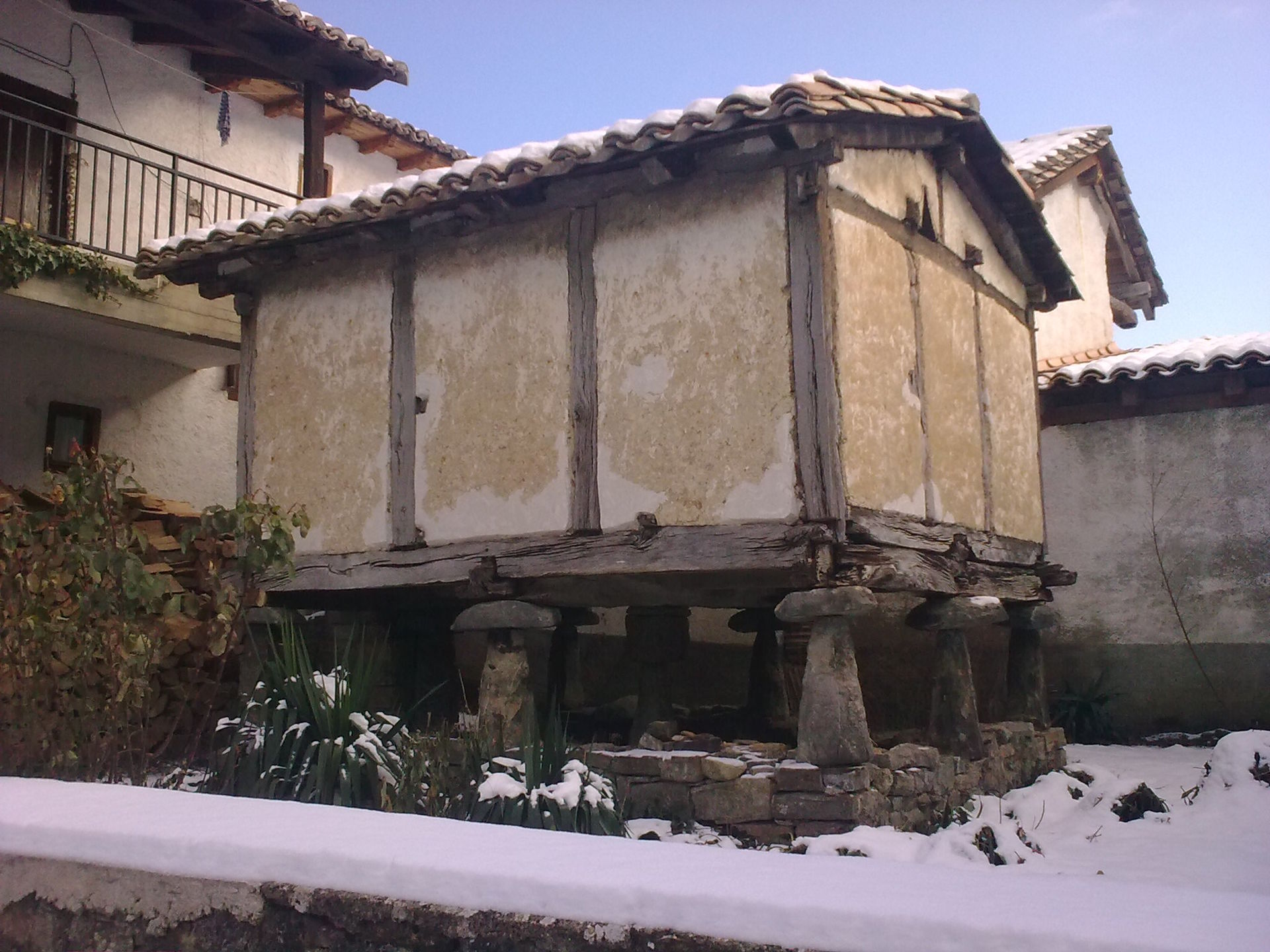
Ballaz
Gallués / Galoze
Ballaz is a historic granary, or hórreo, standing at Casa Ballaz in Izal, a village belonging to the municipality of Gallués/Galoze in the Salazar valley, Navarre. It is the only structure of its kind surviving in the entire valley, and it remains in excellent condition, making it a rare witness to the traditional agricultural architecture of the Pyrenees. What exactly is this hórreo, and why does it matter? A hórreo is a traditional raised granary built on a stone base, designed to keep stored grain and food safe from damp, rodents and pests. The example at Casa Ballaz dates back to the 17th century and blends Pyrenean building traditions with influences from the pre-Pyrenean lowlands, since Izal sits right at the boundary between the two zones. Stone forms the structural skeleton, shaping lintels, walls and arches, while timber was reserved for the roof frame and the granary's internal flooring. One distinctive trait is its gentler roof pitch, covered with curved tile rather than the beech shingle or flat ceramic tile seen on comparable buildings nearby. The rendered exterior of its stone walls also sets it apart from the hórreos typical of the neighbouring Urraúl area. Despite its modest, compact scale, the building still shows the solidity, slenderness and careful proportion, along with its clear separation from the ground, that mark the finest examples of Navarrese granary architecture. How do you get to Ballaz? Ballaz stands in Izal, a village under the administration of the Gallués/Galoze municipality, roughly 70 km from Pamplona. The Salazar valley occupies the northeastern corner of Navarre, bordered by France to the north, the Roncal valley to the east, the Aézcoa valley to the west, and the Navascués area to the south. A car is by far the easiest way in, since the valley has no rail connection and bus services are limited, so self-driving makes exploring the area far more practical. The building itself lies a few kilometres from Urizabe, another locality within Gallués, which gives a good sense of just how small and scattered the settlements in this part of the valley are. What will you see on site? Beyond the hórreo itself, Izal is worth a stop in its own right: a small stone village typical of Salazar valley architecture, with narrow lanes and houses built from rough-cut stone. The wider Gallués municipality holds other heritage buildings too, including churches and chapels characteristic of the region. The whole Salazar valley is criss-crossed by walking trails through beech and fir forest, appreciated by travellers looking for quiet corners away from Navarre's busier tourist routes. When should you visit? Spring and early autumn are the best times to come, when mountain temperatures are mild and the forest puts on a striking show of colour, autumn especially, when the valley's beech woods turn gold and copper. Summer draws travellers escaping the heat of lower-lying parts of Navarre, while winter can bring difficult conditions, with snow sometimes limiting access to some of the valley roads. Frequently Asked Questions What exactly is Ballaz? It is a historic hórreo, a traditional stone granary dating from the 17th century, located at Casa Ballaz in Izal, within the municipality of Gallués/Galoze. Is it the only one of its kind in the area? Yes, it is the only hórreo still standing in the whole Salazar valley, and it survives in very good condition. Can visitors go inside? The building sits on private property, so viewing is usually limited to the exterior; it is worth checking current access details with the Gallués municipal office before visiting. What else is worth seeing nearby? The village of Izal itself with its traditional stone architecture, the other settlements of the Salazar valley, and the walking trails running through the surrounding beech forests.
-
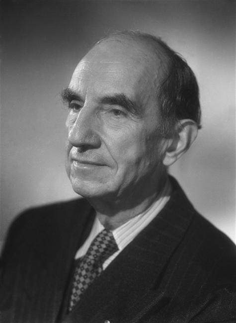
Jules Supervielle
Oloron-Sainte-Marie
Jules Supervielle is a name deeply tied to Oloron-Sainte-Marie, even though the poet himself was born far away, in Montevideo. This small town at the foot of the Pyrenees is where his family roots lie, and today his name lives on in a local school, a cemetery plot, and a literary prize — making it a rare stop where the biography of one of the twentieth century's most distinctive French-language poets intersects with the story of a modest Pyrenean town. Who was Jules Supervielle? Jules Supervielle (1884–1960) was a French-Uruguayan poet and writer. Born in Montevideo, his family nonetheless came from Oloron: his paternal grandfather, born in the town in 1817, worked there as a jeweller and watchmaker, a trade his father Victor Jules Supervielle (born 1854) continued. The poet was orphaned tragically early — both parents died in Oloron when he was just nine months old. Supervielle was nominated for the Nobel Prize in Literature three times, marking him as one of the significant figures of French poetry of his era. What connects the poet to this town? Although he grew up far from France, Supervielle returned to Oloron-Sainte-Marie — most memorably in 1926, when he made a kind of pilgrimage to his family's hometown together with fellow poet Henri Michaux. The trip produced a poetry collection published the following year, simply titled "Oloron-Sainte-Marie," made up of 26 poems inspired by the town and its atmosphere. That collection is what permanently linked the town's name to French literary history. What can you see in Oloron-Sainte-Marie today? Several traces of the poet's memory remain in the town. Since 1960, Supervielle has been buried in the Sainte-Croix cemetery in Oloron, where his wife Pilar was later laid to rest in 1976. In 1971, the town honoured the poet by naming its high school after him — the Lycée Jules Supervielle still operates today as a public secondary school within the Bordeaux education district. The town also established the Prix Jules-Supervielle, a literary award for French-language poets whose winners have included Alain Bosquet, Eugène Guillevic, and Henri Thomas. How to get there and when to visit? Oloron-Sainte-Marie sits in the Pyrénées-Atlantiques department, at the gateway to the Aspe and Ossau valleys, making it a convenient base for both literary tourism and mountain excursions. Spring and early autumn are the best seasons for a walk in Supervielle's footsteps, when the weather is pleasant for exploring the old town and the Sainte-Croix cemetery on foot. A route linking the high school, the cemetery, and the historic centre takes little more than an hour at an easy pace. Frequently asked questions Was Jules Supervielle born in Oloron-Sainte-Marie? No, he was born in Montevideo, Uruguay, but his family came from Oloron, and that heritage shaped much of his personal mythology. Where in town can visitors find traces of the poet? The main sites are his grave in the Sainte-Croix cemetery and the Lycée Jules Supervielle, named after him since 1971. What work did he write about the town? Following his 1926 pilgrimage to Oloron, Supervielle wrote a poetry collection titled "Oloron-Sainte-Marie," published the following year. Is there a prize named after him in the town? Yes, the Prix Jules-Supervielle honours French-language poets, with past winners including Alain Bosquet and Eugène Guillevic.
-
Monument to Victorio Macho, Palencia
Palencia
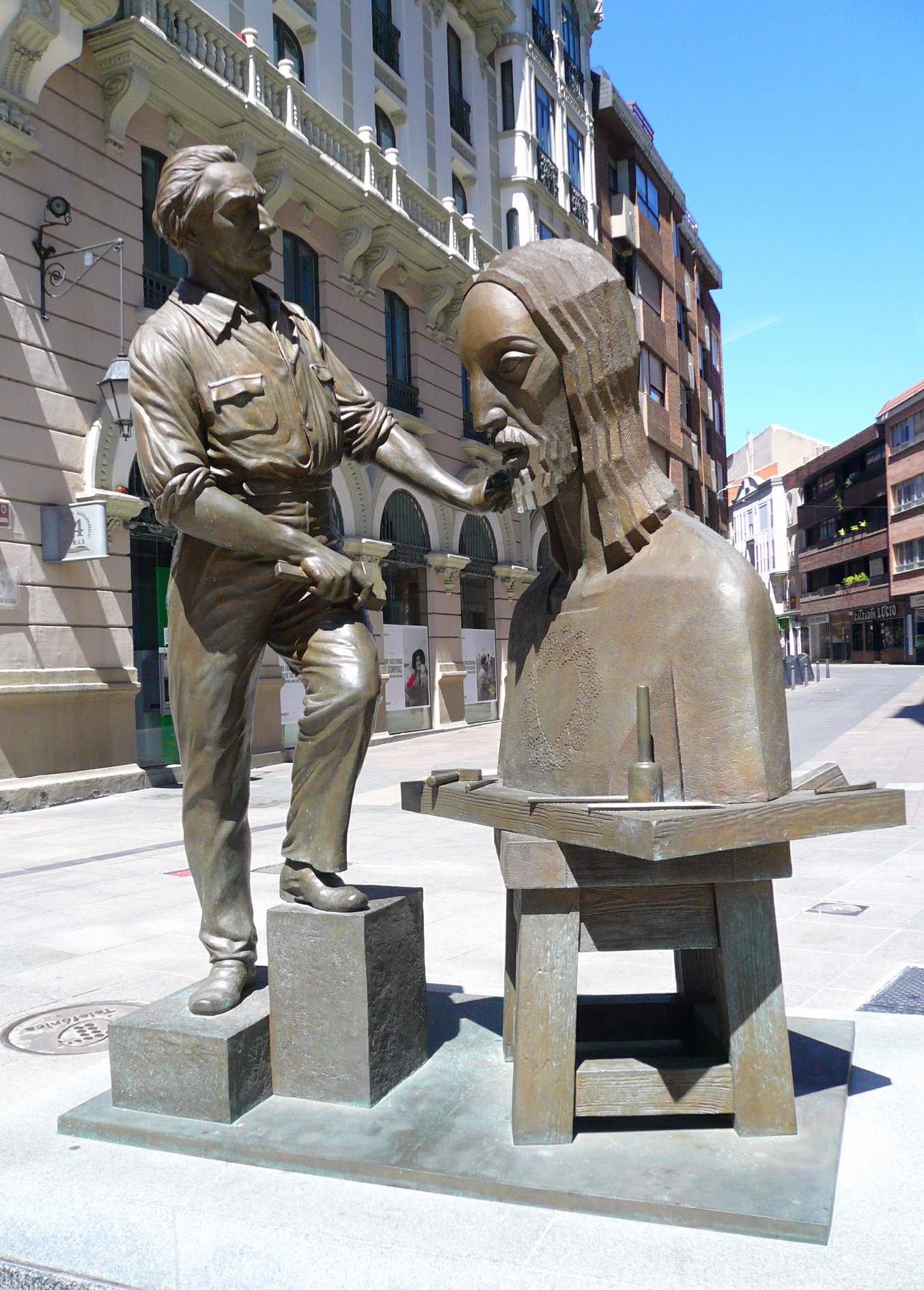
The Monument to Victorio Macho stands on Calle Mayor in Palencia, a bronze tribute unveiled in 2017 to the city's most celebrated sculptor. It's a modest stop on a walk through the historic center, but a good excuse to trace how one artist's work reshaped the skyline of an entire town. Who was Victorio Macho? Victorio Macho (1887-1966) was born in Palencia and went on to become one of the leading Spanish sculptors of the 20th century. Although he spent much of his working life away from his hometown — living at various points in Madrid, New York and Peru before eventually settling in Toledo, where he died — he never cut ties with Palencia. It was here that he created his most recognizable work, the Cristo del Otero, a monumental Christ figure that towers over the city. The statue on Calle Mayor is the town's way of honoring that legacy. What will you see at the monument? The sculpture depicts the artist himself and occupies a prominent spot on Palencia's main shopping street, surrounded by the townhouses and storefronts typical of a mid-sized Castilian city. It's a useful starting point for getting your bearings — from here it's an easy walk to the cathedral and to the other traces of Victorio Macho scattered around the city. Take a moment to read the information plaque before mapping out the rest of a sculptor-themed route. What else in Palencia is connected to Victorio Macho? The essential follow-up to the monument is a trip up Otero hill, home to the Cristo del Otero, a roughly 21-meter Christ figure completed in 1931 and one of the tallest sculptures of its kind anywhere in the world. The artist himself is buried at its base. Right next to it sits an interpretation center dedicated to Victorio Macho, where entry is free and visitors can see sketches, scale models, photographs and tools that trace how the giant Christ came to be built. Back in the center, on Plaza Mayor, stands another Macho work, a monument to the Renaissance sculptor Alonso Berruguete unveiled in 1963, while his "Iberian Peasant" sculpture greets arrivals from the Tierra de Campos region along Avenida de Asturias. How to get there? Calle Mayor is Palencia's main, largely pedestrianized street, so the monument is easiest reached on foot from either the train or bus station, both around fifteen minutes' walk from the center. Palencia sits on the Madrid-León rail line, making it a convenient stop on a wider trip through Castile and León. For Otero hill and the Cristo del Otero, it's worth taking a car, taxi or local bus, since the walk up from downtown is longer and involves a real climb. When to visit? Spring and autumn are the most comfortable seasons to explore Palencia, since summers can get quite hot on the open Castilian plateau. The interpretation center by the Cristo del Otero keeps limited opening hours, so it's worth checking the current schedule locally or with the tourist information office before heading up. The monument on Calle Mayor itself is accessible year-round, at any time of day. Frequently asked questions Where exactly is the Monument to Victorio Macho? On Calle Mayor, Palencia's main shopping street, right in the heart of the city center. Is the monument the same thing as the Cristo del Otero? No. The Calle Mayor statue is a tribute to the artist himself, while the Cristo del Otero is his best-known work, a monumental Christ figure on the hill above the city. Is admission to the interpretation center free? Yes, entry to the center dedicated to Victorio Macho next to the Cristo del Otero is free of charge. How long does it take to see everything related to Victorio Macho in Palencia? The monument itself takes just a few minutes, but a full route covering the Cristo del Otero, the interpretation center and the Berruguete monument on Plaza Mayor takes two to three hours, depending on your pace.
-
Monument to Jules Verne
Vigo
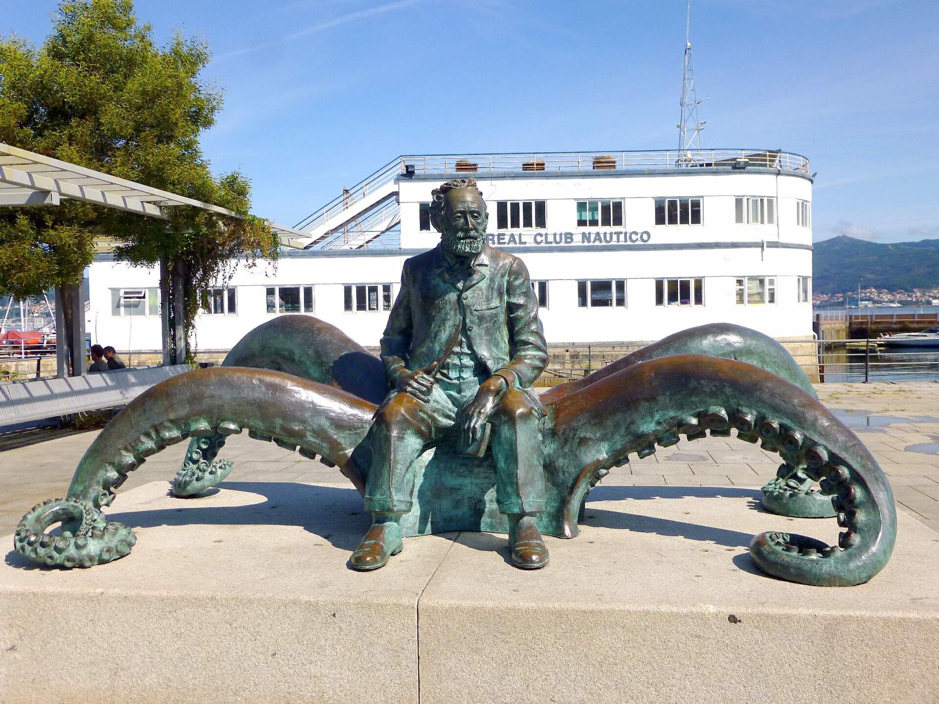
The Monument to Jules Verne stands proudly on the waterfront of Vigo, a port city on Spain's Ría de Vigo in Galicia. Cast in bronze, the statue shows the writer seated astride a giant squid-like sea creature — a direct nod to his most famous novel, "Twenty Thousand Leagues Under the Sea." Why does Vigo have a Jules Verne monument? The link between Verne and this city is no coincidence. In the novel, Vigo Bay is the very spot where Captain Nemo, aboard the Nautilus, discovers a sunken treasure — a reference to real history: in 1702, during the Battle of Vigo Bay, a Spanish treasure fleet and its French naval escort were destroyed here by an Anglo-Dutch force, and legends of gold still resting on the seabed persist to this day. Verne wove this episode into his story, permanently placing Vigo on the literary map of Nemo's underwater adventures. The monument was unveiled in 2005, marking the 100th anniversary of Verne's death. It was created by Galician sculptor José Molares, known for several large-scale works across the region. The bronze figure stands roughly 2.5 meters tall and weighs more than 1,500 kilograms — a substantial, striking piece that has become an unofficial landmark of Vigo's seafront promenade. How do you get there? The monument sits on Muelle de las Avenidas, the city's main waterfront promenade, right next to the port and marina in the heart of Vigo. It's an easy walk from the city center — just a few minutes from the main squares and shopping streets. There's no entrance, gate, or ticket: the statue stands in open public space and can be visited at any hour. What will you see there? Beyond the sculpture itself, it's worth lingering on the waterfront — the spot offers views across Ría de Vigo, one of the most scenic bays on the Galician coast, and on a clear day you can spot the Cíes Islands in the distance, often ranked among Europe's most beautiful beaches. The monument itself is a favorite photo stop: the dynamic pose of the writer riding a sea creature draws both tourists and locals looking for a memorable snapshot. When is the best time to visit? Since the monument stands outdoors on an open quay, it can be visited year-round. Spring and early autumn offer the most comfortable conditions for sightseeing and photography, with mild temperatures and soft afternoon light falling across the statue from the direction of the bay. In summer, the waterfront tends to get busier due to tourist traffic and cruise ships docking at the port of Vigo. Frequently asked questions Is there an entrance fee for the monument? No, the monument stands in a public open-air space on the waterfront and can be visited free of charge at any time. Why does Jules Verne have a monument specifically in Vigo? Because the writer set the hidden treasure of "Twenty Thousand Leagues Under the Sea" in Vigo Bay, referencing the real sunken Spanish treasure fleet from the Battle of Vigo Bay in 1702. Who designed the sculpture? It's the work of Galician sculptor José Molares, unveiled in 2005 on the 100th anniversary of Verne's death. How much time should I set aside? It's a quick stop — 10 to 15 minutes is enough to view the sculpture and take photos, though it pairs well with a longer walk along the full Muelle de las Avenidas promenade.
-
Fray Benito Feijoo (sculpture)
Oviedo
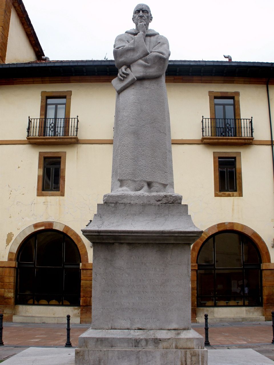
The Fray Benito Feijoo monument stands in Plaza de Feijoo in Oviedo, one of more than a hundred street sculptures that give this Asturian city its distinctive open-air gallery feel. Carved in stone by sculptor Gerardo Zaragoza in 1953, the statue portrays the Benedictine monk Benito Jerónimo Feijoo, one of the most influential Spanish writers and thinkers of the 18th century. Who was Fray Benito Feijoo? Benito Jerónimo Feijoo was a Benedictine monk, abbot of the Monastery of San Vicente, and professor of theology at the University of Oviedo, where he taught from 1710 to 1739. He became known for his essays challenging superstition and promoting scientific reasoning, playing a key role in bringing Enlightenment ideas to Spain. He lived at the San Vicente monastery from 1709 until his death, occupying a cell whose windows are still preserved in the building today. Where exactly is the statue, and why does it face that way? The sculpture is deliberately positioned to look directly at the facade and the windows of the cell where Feijoo spent most of his life. That former monastery building now houses the Archaeological Museum of Asturias, and much of its original architecture has survived intact. This quiet symbolic gesture — a monument gazing toward the very room where its subject lived — is one of the more thoughtful details tucked into Oviedo's public spaces. Why is this monument worth a stop? Oviedo is famous for its abundant street art, with over a hundred statues scattered across the city forming an informal open-air museum. The Feijoo monument is one of the older pieces in that collection, dating back to 1953, and its location right next to the archaeological museum makes it a natural stop while exploring the historic center. Plaza de Feijoo itself is a small, quiet square, ideal for pausing to take in the stonework up close. How do you get to Plaza de Feijoo? The square sits in Oviedo's historic center, within easy walking distance of the cathedral and the main old-town landmarks. It pairs naturally with a visit to the Archaeological Museum of Asturias, located directly across from the statue — the very building the monument was designed to face. Frequently asked questions Who created the Fray Benito Feijoo monument? The stone sculpture was made by Spanish artist Gerardo Zaragoza and dates from 1953. Who was Benito Jerónimo Feijoo? He was a Benedictine monk, abbot of the Monastery of San Vicente, and professor of theology at the University of Oviedo from 1710 to 1739, remembered as one of Spain's most important 18th-century writers and thinkers. Why does the statue face in that particular direction? It looks toward the facade and windows of the cell where Feijoo lived from 1709 until his death — the building now houses the Archaeological Museum of Asturias. What else is nearby worth seeing? The Archaeological Museum of Asturias sits right across from the monument, and Oviedo's historic center nearby is dotted with dozens of other street sculptures worth including on the same walk.
-
La ciudad honra a sus funcionarios
Zaragoza
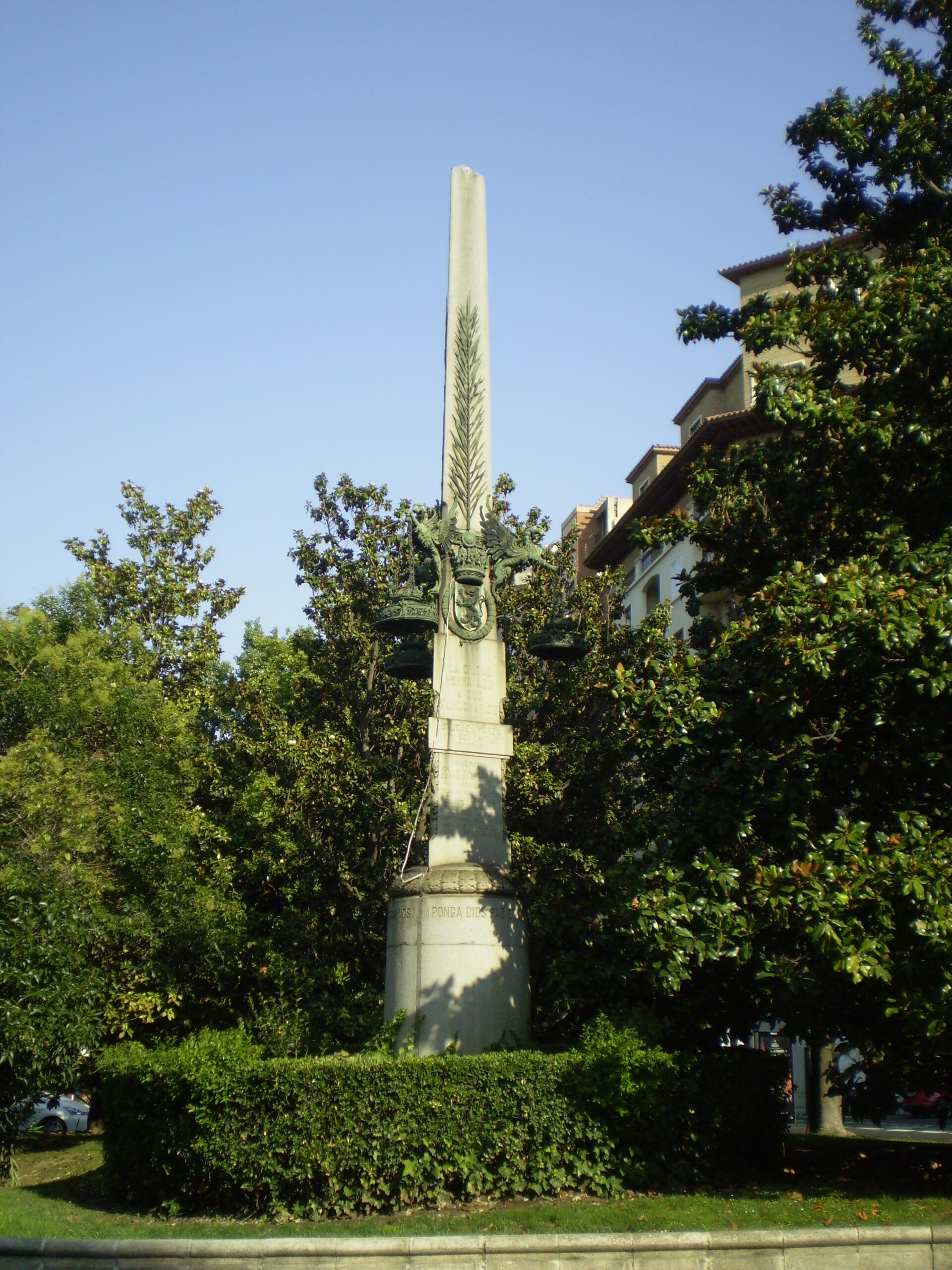
"La ciudad honra a sus funcionarios" is a modest but striking monument in Zaragoza — a cenotaph raised for three city officials killed while doing their jobs. It stands on Paseo de la Constitución, at the roundabout where the avenue meets Hernando de Aragón, Isaac Peral and San Ignacio de Loyola streets, though it wasn't always there. What happened here? On 23 August 1920, during a strike by electricians, three municipal employees went out to fix a fault in the street lighting. They were the architect José de Yarza y de Echenique, the engineer César Boente y Álvarez, and the clerk Joaquín Octavio de Toledo. While they worked, an unidentified man fired three shots at them; all three died on the spot. The killing shocked the city, and calls soon followed for a lasting memorial to their memory. Who designed the monument, and when was it built? The monument was unveiled in 1924. The architectural design came from Miguel Ángel Navarro Pérez, while the sculptural work was carried out by Joaquín Tobajas. It originally stood on Paseo de la Independencia, one of Zaragoza's main avenues, before being moved to its current site on Paseo de la Constitución in 1961. What does the monument look like? A cylindrical base decorated with a laurel-leaf molding supports a monolithic, three-sided obelisk carved from grey granite. Bronze ornaments bring the stone to life: palm leaves, the coat of arms of Zaragoza, and three winged griffins holding up suspended electric lamps, each fitted with nine bulbs — a detail that points directly back to the streetlight repair the honored men were carrying out when they died. What do the inscriptions say? The base carries the words "LA CIUDAD HONRA AQUÍ A SUS FUNCIONARIOS" ("Here the city honors its officials"), and below it a more personal, almost prayer-like line: "¡PONGA DIOS PAZ EN LAS LUCHAS SOCIALES QUE LLEVAN A ESTOS HORRIBLES DESCAMINOS!" ("May God bring peace to the social struggles that lead to such terrible paths"). That second inscription speaks directly to the tense labor conflicts of the early 1920s, when strikes in Spain could turn violent. Why is it worth a stop? Walking through central Zaragoza, this small memorial is easy to miss — yet it holds a piece of local social history rarely covered in guidebooks. It's a reminder that behind a city's grand architecture there are also specific, dramatic events and ordinary public servants who lost their lives doing everyday work for the people they served. Frequently asked questions Where does the "La ciudad honra a sus funcionarios" monument stand? On Paseo de la Constitución in Zaragoza, at the roundabout where it meets Hernando de Aragón, Isaac Peral and San Ignacio de Loyola streets. From 1924 to 1961 it stood on Paseo de la Independencia. Who is the monument dedicated to? Three municipal employees murdered on 23 August 1920 while repairing street lighting: the architect José de Yarza y de Echenique, the engineer César Boente y Álvarez, and the clerk Joaquín Octavio de Toledo. Who created the monument? The architectural design is by Miguel Ángel Navarro Pérez, and the sculpture by Joaquín Tobajas. It was unveiled in 1924. What materials was it made from? The base and obelisk are grey granite, while the decorative elements — palm leaves, the city's coat of arms, and the lamp-bearing griffins — are cast in bronze.
-

M60
Burgos
M60 Patton is a preserved Cold War-era American main battle tank, displayed as a permanent open-air monument in Burgos, giving visitors a rare close-up look at 20th-century military hardware. What exactly are you looking at? The M60 grew directly out of the earlier M48 tank, though it never carried the "Patton" name in its official military designation — despite that, the nickname stuck, keeping it linked to the lineage of vehicles named after General George Patton. The tank was formally standardized in March 1959 under the designation Tank, Combat, Full Tracked: 105-mm Gun, M60. Historians and engineers alike describe it as a "product-improved descendant" of the Patton design rather than an entirely new vehicle — the family resemblance is obvious when you line up an early M60 next to an M48A2. Its place in American military history is hard to overstate. In 1963, once the Marine Corps retired its last heavy-tank battalion (the M103), the United States committed fully to a single main battle tank doctrine — and the M60 became that tank for most of the Cold War. Production eventually reached roughly 15,000 units, making it one of the most widely built armored vehicles of its era. Hull production wound down in 1983, but the story didn't end there: 5,400 older hulls were later upgraded to the improved M60A3 standard, a conversion program that ran until 1990. What will you see? Up close, the tank's scale is the first thing that strikes visitors — the heavy turret, the long 105-mm gun barrel, and the tracked hull that formed the backbone of American armored forces for decades. It's an unusually direct way to encounter a machine that stood on the front line of East–West tension, and to trace how armor design evolved from the original M48 through to the later A3 upgrades. How do you get there? The tank stands in Burgos as part of the public urban landscape, freely accessible without tickets or reservations. The easiest way to reach it is on foot or by local public transport, following the routes that connect the city centre with the surrounding neighbourhoods. When should you visit? Because it's an outdoor exhibit, there's no opening schedule to work around — you can stop by any day, at any hour. That said, the visit is most pleasant in mild weather, in spring or autumn, when a longer walk around the site and a proper look at the details is more comfortable. Frequently asked questions Is there an entrance fee? No — as an open-air monument in public space, it's free to view at any time. Is this an original Cold War-era vehicle? Yes, the tank on display belongs to the M60 family, first standardized in 1959 and produced well into the 1980s. How does the M60 differ from the earlier M48? Despite clear structural similarities, the M60 introduced a number of technical refinements, which is why it's often described as an improved evolution of the M48 rather than a wholly new tank. How much time should you plan for a visit? Seeing the vehicle itself takes only a few minutes, but it's worth pairing the stop with a walk through the surrounding part of Burgos.
-
Mircea Eliade
Cascais
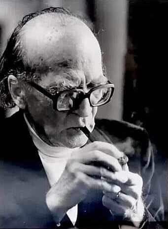
Mircea Eliade is the name of a street in Cascais, the Portuguese coastal town, honoring the Romanian scholar and writer whose life became linked to Portugal for several years. Who was Mircea Eliade? Eliade built his reputation above all as a historian of religion and a leading figure in comparative religious studies, though he was also trained as an Indologist and philosopher of culture. Alongside his academic work he wrote essays and novels, and for a period he also served as a diplomat. Today he is remembered as one of the towering figures of twentieth-century religious scholarship, largely because of two connected ideas. The first holds that an encounter with the sacred - a hierophany - splits ordinary experience into sacred and profane realms, both in space and in time. The second, his theory of the eternal return, argues that myths and rituals do more than recall past sacred events: through repetition, communities in a sense re-enter and relive them. Why does a street in Cascais carry his name? Eliade's connection to Portugal was not incidental. During the Second World War he served as cultural attaché of the Romanian legation in Lisbon, spending several years in a country that stayed neutral throughout the conflict. That chapter of his life is what the Cascais street commemorates - a town that, together with neighboring Estoril, sheltered numerous European exiles, diplomats, and aristocrats seeking refuge from the war during those years. What else should visitors know about the area? Cascais sits at the western edge of what is often called the Portuguese Riviera, where the Tagus estuary meets the Atlantic, a short distance from Lisbon. Once a modest fishing village, it grew into an elegant resort town with a historic center, a marina, and a string of sandy beaches. Its mild climate and closeness to the capital have long drawn both visitors and residents looking for a quieter life by the sea. Street names like this one offer a small window into the town's twentieth-century ties to wider European history and culture. Getting there and best time to visit Cascais is easiest to reach by train from Lisbon: the coastal line from Cais do Sodré station runs along the shoreline and terminates in the town, making it a straightforward day trip. Spring and early autumn are the most comfortable seasons to visit, since summer brings hotter weather and larger crowds drawn by the nearby beaches. Frequently Asked Questions Why is a street in Cascais named after Mircea Eliade? It commemorates the Romanian historian of religion and writer who spent several years in Lisbon during the Second World War as cultural attaché of the Romanian legation. What was Mircea Eliade known for? He was a historian of religion and comparative religious scholar, also trained as an Indologist and philosopher of culture, who wrote essays and novels and worked at times as a diplomat. He developed the influential theories of hierophany and the eternal return. How do you get to Cascais from Lisbon? The simplest way is the coastal train line from Cais do Sodré station, which runs along the shore and ends in Cascais. When is the best time to visit Cascais? Spring and early autumn bring mild weather and smaller crowds, though summer remains the most popular season thanks to the beaches.
-
Agustín Argüelles
Ribadesella/Ribeseya
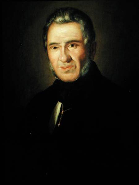
Agustín Argüelles is one of the main streets of Ribadesella/Ribeseya, a coastal town in Asturias, named after the local-born statesman it honors. The Gran Vía de Agustín Argüelles runs through the town center, tying everyday life to a piece of history worth a short detour while exploring the area. Who was the street named after? Agustín Argüelles (1776–1844) was born in Ribadesella and died in Madrid, and he ranks among the most influential Spanish liberal politicians of the early 19th century. He sat as a deputy in the Cortes of Cádiz and co-authored the 1812 Constitution — a cornerstone document of Spanish liberalism — later contributing to the 1837 Constitution as well. He served as Minister of the Interior during the Liberal Triennium (1820–1823) and held the presidency of the Congress of Deputies on two separate occasions. That record of public service is why his hometown named one of its principal streets after him. What can you see nearby? The street itself works as a practical landmark while walking through Ribadesella, running through the part of town where shops, cafés and daily foot traffic concentrate. Travelers curious about the man behind the name can head to the town hall, where an iron-cast bust of Argüelles stands in the entrance hall — a modest but tangible piece of civic memory tucked inside the administrative building of his native town. How do you get there? Ribadesella sits on the Asturian coast at the mouth of the Sella river, connected by the N-632 national road linking Gijón and Santander. The town is also reachable by the FEVE regional railway and long-distance coach services. Gran Vía runs through the town center within walking distance of the station and the main parking areas, so a car isn't required once you've arrived. When is the best time to visit? Ribadesella is busiest in summer, when its beaches and festivals draw visitors from across Spain, but a stroll through the historic center and streets like this one works year-round. Spring and autumn offer a quieter pace for taking in the town's architecture and monuments, while winter visits mean having the streets largely to yourself. Frequently asked questions Is Gran Vía de Agustín Argüelles a tourist attraction on its own? It's primarily a working street through the town center, but its name and the story behind it make it a point of interest for anyone curious about Spanish and Asturian history. Where can I see a likeness of Agustín Argüelles? An iron-cast bust of the politician stands in the entrance hall of Ribadesella's town hall, the closest physical memorial in his birthplace. Is it worth combining a walk here with other Ribadesella sights? Yes — the town center is compact, so it's easy to pair a walk along Gran Vía with a visit to the harbor, Santa Marina beach, or the old town. Why does Agustín Argüelles matter to Spanish history? He co-authored the 1812 and 1837 constitutions, served as Minister of the Interior, and twice presided over the Congress of Deputies — making him one of the defining figures of 19th-century Spanish liberalism.
-
Panteón Guirao
Madryt
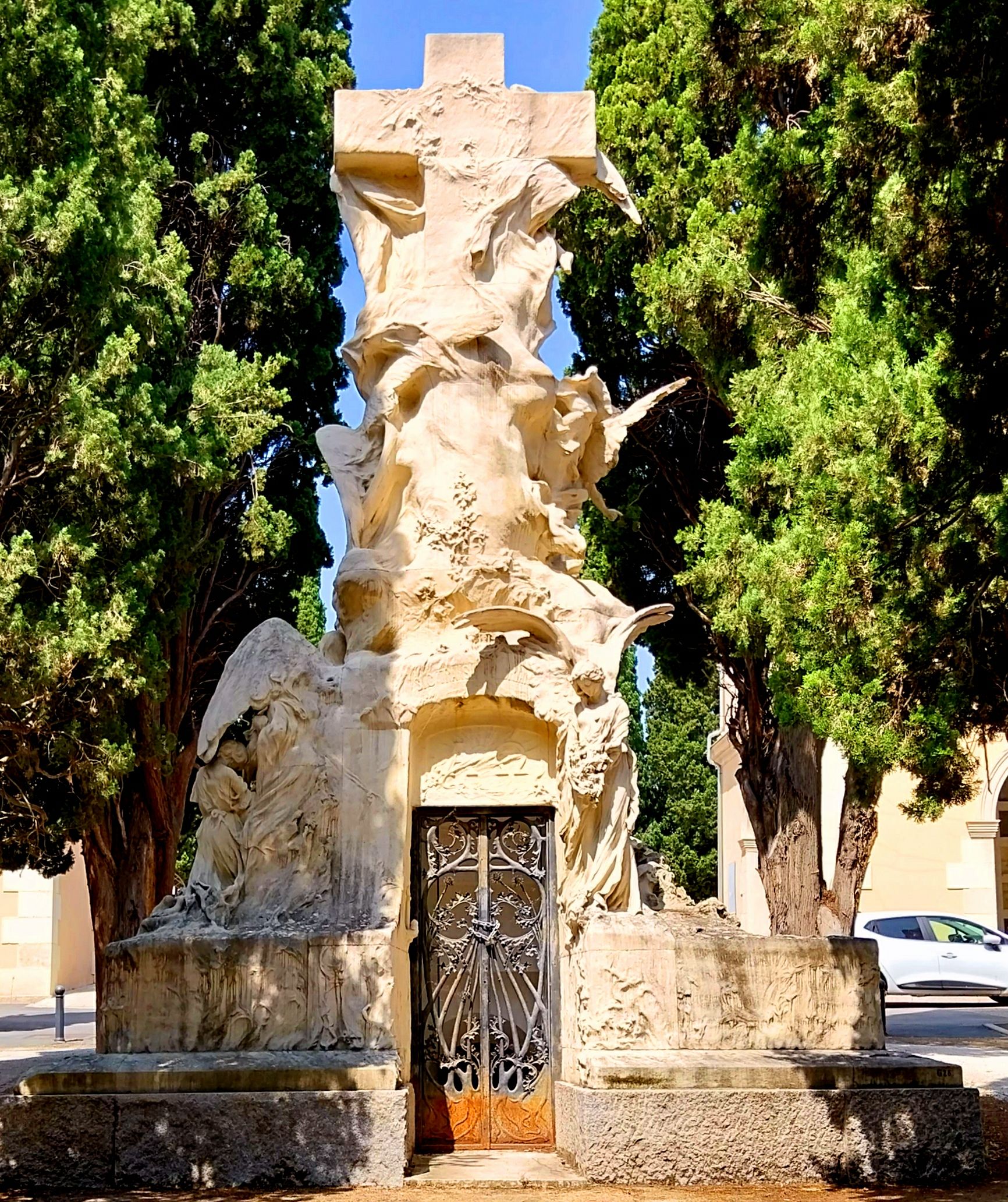
Panteón Guirao is an Art Nouveau mausoleum in the San Isidro Sacramental Cemetery in Madrid, in the Carabanchel district. It ranks among the finest works of funerary art from the Spanish Modernist period and draws visitors interested in architecture and local history who come to the cemetery searching for sculptural treasures tucked among its avenues. What is this place? Also known as the tomb of Luisa Sancho Mata, the mausoleum was built in the early 20th century at the request of Luis Federico Guirao y Girada, a lawyer, politician and photographer. He commissioned it in 1908 as a resting place for his wife, Luisa Sancho Mata, who had died the previous year. The design and sculptural work were entrusted to the Catalan sculptor Agustín Querol Subirats, one of the leading Spanish sculptors of the turn of the century. Querol died in 1909 before the work was finished, and his workshop completed the commission in 1911. What will you see? The structure has a circular floor plan topped by a hemispherical dome, giving it the shape of a small temple. The entrance is fitted with a wrought-iron gate decorated with plant motifs — vines and thistles intertwined in the flowing, dynamic patterns typical of Art Nouveau. The limestone structure rises over two levels, with fourteen angelic figures arranged around a central cross. Inside stands a sarcophagus bearing the name of Luisa Sancho Mata. The whole composition acts as a landmark at the end of the main axis of the Patio de la Concepción, one of the cemetery's sections, where the mausoleum rises like an architectural focal point closing the view down the avenue. The sculptural detail — the angels' faces, the flowing lines of the iron gate, the dome's proportions — shows how Spanish Modernism found its way into funerary art, a field usually associated with gravity and restraint. Here the form is light, ornamental and clearly inspired by nature, setting the mausoleum apart from the more classical tombs around it. How to get there? Panteón Guirao stands within the San Isidro Sacramental Cemetery (Sacramental de San Isidro), one of Madrid's historic cemeteries located in the Carabanchel district, close to the Manzanares riverbed. The easiest way to reach it is by metro or city bus — stops around Puente de Toledo and Paseo de la Ermita del Santo are within walking distance of the cemetery gates. It's worth setting aside some unhurried time, since the grounds are extensive and the mausoleum sits deep within one of the cemetery's patios. When to visit? The cemetery is open daily, and the best time to visit is morning or early afternoon, when the light picks out the detail of the wrought-iron gate and the sculptures well. Spring and autumn are the most pleasant seasons for walking the grounds, avoiding the heat typical of Madrid summers. Since this is an active resting place, visitors should approach it respectfully, keeping quiet and giving space to the surrounding graves. Frequently asked questions What is Panteón Guirao? It's an Art Nouveau family mausoleum in Madrid's San Isidro Cemetery, built in the early 20th century as the resting place of Luisa Sancho Mata. Who designed the mausoleum? The design and sculptures were created by the Catalan sculptor Agustín Querol Subirats; after his death in 1909, his workshop completed the finishing work in 1911. Where exactly is it located? Within the San Isidro Sacramental Cemetery in the Carabanchel district, at the end of the main axis of the Patio de la Concepción. Is entry free? Yes, the cemetery is open to the public and can be visited free of charge during opening hours, while respecting the rules that apply on the grounds.
-
Teatro Variedades
Madryt
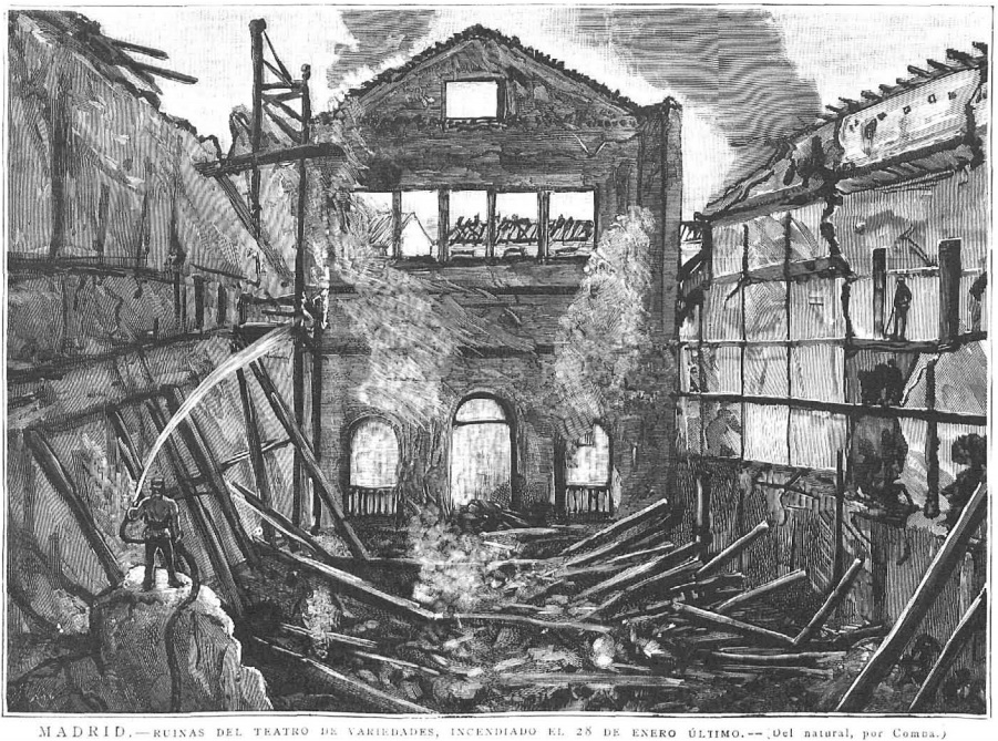
Teatro Variedades was a 19th-century theatre in Madrid that no longer exists, yet its story remains a memorable footnote in the city's history of popular entertainment. The building itself is gone, but the spot where it once stood can still be visited while exploring Madrid's historic centre. Where was it located? The theatre stood at what was then Calle de la Magdalena 40, right in central Madrid, in an area bordering Lavapiés and the Antón Martín square. This part of the city is densely packed with narrow streets and 19th-century townhouses, and today it remains one of the most walkable and atmospheric corners of old Madrid. What was its history? Teatro Variedades was built in 1847. In 19th-century Madrid it earned the nickname of the city's "Colosseum" and became one of the more popular entertainment venues of its time, catering to a broad, undemanding public looking for light evening amusement. Its programme leaned heavily on the bouffe genre, political revues, and other minor theatrical forms that were widely enjoyed by ordinary Madrileños. It was not a prestigious dramatic stage but rather a hub of accessible, mass-market entertainment — the kind of venue common in many 19th-century European cities. What happened to it? The theatre's story came to an abrupt end. On 29 January 1888, the building was destroyed by fire. Because much of its structure relied on wooden foundations and load-bearing elements, the damage was severe enough that the building was ultimately demolished. Since then, Teatro Variedades has survived only in historical records and in accounts of Madrid's past theatrical life. What can you see there today? No physical trace of the original theatre remains on site — the fire and subsequent demolition left nothing of the original structure standing. Still, for visitors interested in the city's history, the location is a worthwhile stop on a mental map of old entertainment-era Madrid, especially when combined with a walk through the surrounding historic streets of the centre and neighbouring Lavapiés, an area that still retains much of its 19th-century character. When is the best time to visit? Since the main draw here is simply walking through this part of historic Madrid, spring and autumn are the most pleasant seasons, when mild temperatures make it easy to spend time wandering the narrow streets without the intense heat typical of Madrid summers. It's worth pairing a visit to this area with other nearby sights in the city centre, as the neighbourhood is well connected to the rest of Madrid by public transport. Frequently asked questions Can you still visit Teatro Variedades today? No — the building burned down in 1888 and was subsequently demolished. It survives only in historical records, and no physical remains exist at the site. Where exactly was the theatre located? At the former Calle de la Magdalena 40, in central Madrid, in the area bordering Lavapiés and the Antón Martín square. What kind of shows were performed there? The programme mainly featured the bouffe genre, political revues, and other light theatrical forms aimed at a broad, easy-going 19th-century Madrid audience. Why did the theatre stop existing? On 29 January 1888, the building was destroyed by fire. Because of its wooden foundations, the damage was extensive enough that it was ultimately torn down.
-
Torre de l'Aigua
Sabadell
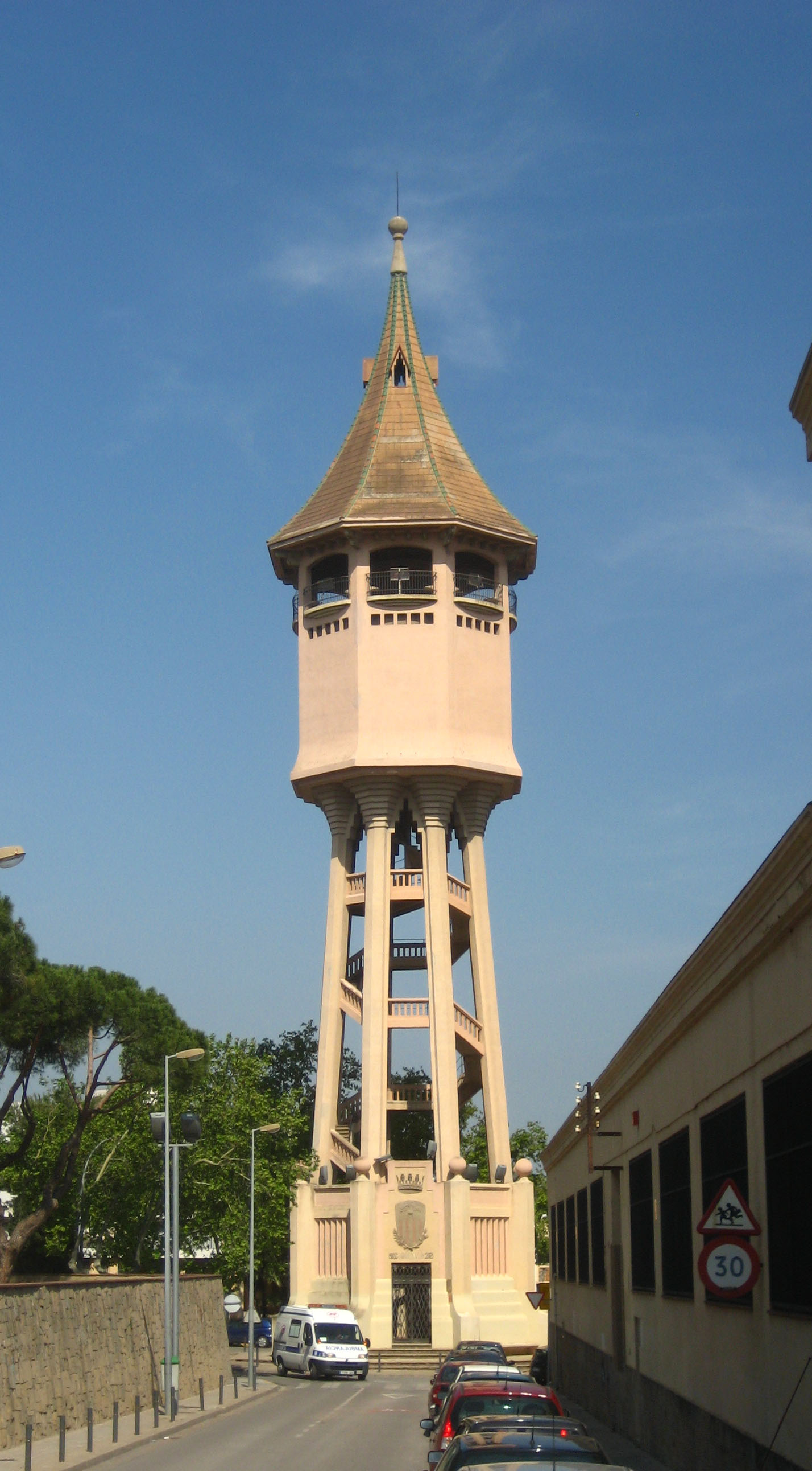
Torre de l'Aigua is a modernist water tower in Sabadell and one of the city's most recognizable landmarks. It rises on the eastern edge of Sabadell, right next to the Ripoll river and the road toward Caldes de Montbui, so it's hard to miss even on a first visit. Where does this tower come from? Construction began in 1916 and wrapped up in 1918, based on a design by engineer Francesc Izard together with architect Lluís Homs. The goal was strictly practical: store and distribute water for a fast-growing industrial Sabadell. The tower went into service as an active reservoir in 1922 and kept working until 1967, pulling water from wells along the Ripoll river and sending it across the city by gravity. What turned a working reservoir into a landmark was the way its industrial job was paired with an ambitious modernist design — today it's registered as a local cultural heritage site and counted among the 100 recognized elements of Catalonia's industrial heritage. What will you actually see? The tower stands roughly 50 metres tall, built as an octagonal, pyramid-like structure — eight massive pillars topped with capitals and a cornice, linked by a spiral staircase running up to the top. It was one of the first structures in Sabadell built in reinforced concrete, a bold technical choice at a time when brick and stone still dominated local construction. The result mixes raw engineering geometry with the ornamental touches typical of Catalan modernisme, so the tower reads as part factory, part sculpture. How to get there and when to go? Torre de l'Aigua sits on the eastern side of Sabadell, an easy walk or short ride from the city centre — Sabadell itself is well connected by train to Barcelona, so it fits neatly into a day trip. The inside isn't open on a regular basis; the best chance to visit with a guide is during Festa Major, the city's patron saint festival held on the first weekend of September. On any other day, the tower is still worth seeing from the outside, especially around sunset, when the light brings out the geometry of the pillars. Who is this stop for? It's a natural stop for anyone interested in industrial architecture or Catalan modernisme, and a good way to see a side of Sabadell beyond its shopping streets or the Banc Sabadell stadium. The tower pairs well with the rest of the city's industrial heritage trail, including the former textile mills nearby. Frequently Asked Questions Can you go inside the tower? The interior is generally open to visitors only during Festa Major, on the first weekend of September; access outside that window is limited. How tall is Torre de l'Aigua? The tower is about 50 metres high and visible from many points across eastern Sabadell. Who designed the tower? Engineer Francesc Izard drew up the structure, with architect Lluís Homs handling the design; construction finished in 1918. Why does this tower matter to Sabadell? It supplied the city with water for decades and is now considered one of Sabadell's symbols, listed among Catalonia's 100 industrial heritage elements.
-
Bosque de Luz
Vitoria-Gasteiz
Bosque de Luz is a memorial ensemble in Vitoria-Gasteiz dedicated to the memory of those persecuted by the Franco regime during and after the Spanish Civil War. It stands behind Plaza de la Provincia, right in the heart of this Basque city, and ranks among the most significant sites of historical memory in the province of Álava. What exactly is this place? "Bosque de Luz" — literally "Forest of Light" — is a small, symbolic memorial space tucked away at the rear of Plaza de la Provincia, one of Vitoria-Gasteiz's central squares. The centerpiece is a monolith inscribed "In Memoriam", surrounded by a sculptural composition whose form evokes a forest, giving the memorial its name. The space was designed as a quiet spot for reflection, deliberately set apart from the bustle of the surrounding streets and shopping areas. Who is being commemorated here? The memorial honors the victims of reprisals carried out by Francoist forces against Republicans and other opponents of the dictatorship, both during the Civil War (1936–1939) and in the repressive years that followed — a period historians often refer to as Spain's "White Terror." Death toll estimates for these reprisals across the country vary widely, ranging from roughly 150,000 to 400,000 people depending on the source. Each year, regional and municipal authorities in Álava and Vitoria-Gasteiz hold commemorative ceremonies here, including a moment of silence and floral tributes laid at the monolith, with the Diputación Foral de Álava and the city council both taking part. Has the memorial been controversial? Yes. The way the memorial was originally designed and inaugurated drew criticism from some historical memory associations, who argued that its initial scope did not fully include other groups of victims — such as those affected by police violence or state-sponsored terrorism in later decades. This ongoing debate reflects how historical memory remains a live and contested issue in the Basque Country, with different views on who should be remembered and how. What will you actually see there? Bosque de Luz functions as a permanent, low-key fixture on Vitoria-Gasteiz's memory map — a quiet, understated spot without heavy tourist infrastructure, but meaningful for anyone interested in tracing 20th-century Spanish history off the usual sightseeing routes. Visitors will find the "In Memoriam" monolith surrounded by greenery and symbolic elements, and, around official or civic commemorations, flowers and candles left by victims' families and institutional representatives. How do you get there? Plaza de la Provincia sits in the center of Vitoria-Gasteiz, an easy walk from the old town's main landmarks and the cathedral. No special trip is needed — it's a short detour while exploring the city center, and the site itself can be seen in just a few minutes, though it's worth pausing there for a moment of quiet reflection. Frequently asked questions What does the name "Bosque de Luz" mean? It's Spanish for "Forest of Light" — the name refers to the forest-like symbolic form of the memorial composition, meant to contrast with the dark period of history it commemorates. Who exactly is this memorial dedicated to? People persecuted by the Franco regime during and after the Spanish Civil War, primarily Republicans and other political opponents of the dictatorship. Is there an entrance fee? No, it's an open public space, freely accessible year-round with no set opening hours. Are there any ceremonies held nearby? Yes, on anniversaries linked to historical memory, regional and city authorities occasionally hold ceremonies here, including a moment of silence and flowers laid at the monolith.
Earn badges for the places you visit
Download NextOnTrip, discover new places and check off your trails.