Monuments in Spain
A guide to 4655 Monuments in Spain — with descriptions, photos and traveler visits from the NextOnTrip community. Locations spread across 2240 cities and towns. Most visited by the community: castle of Chulilla, Castle of Pioz, castell de la Todolella.
-
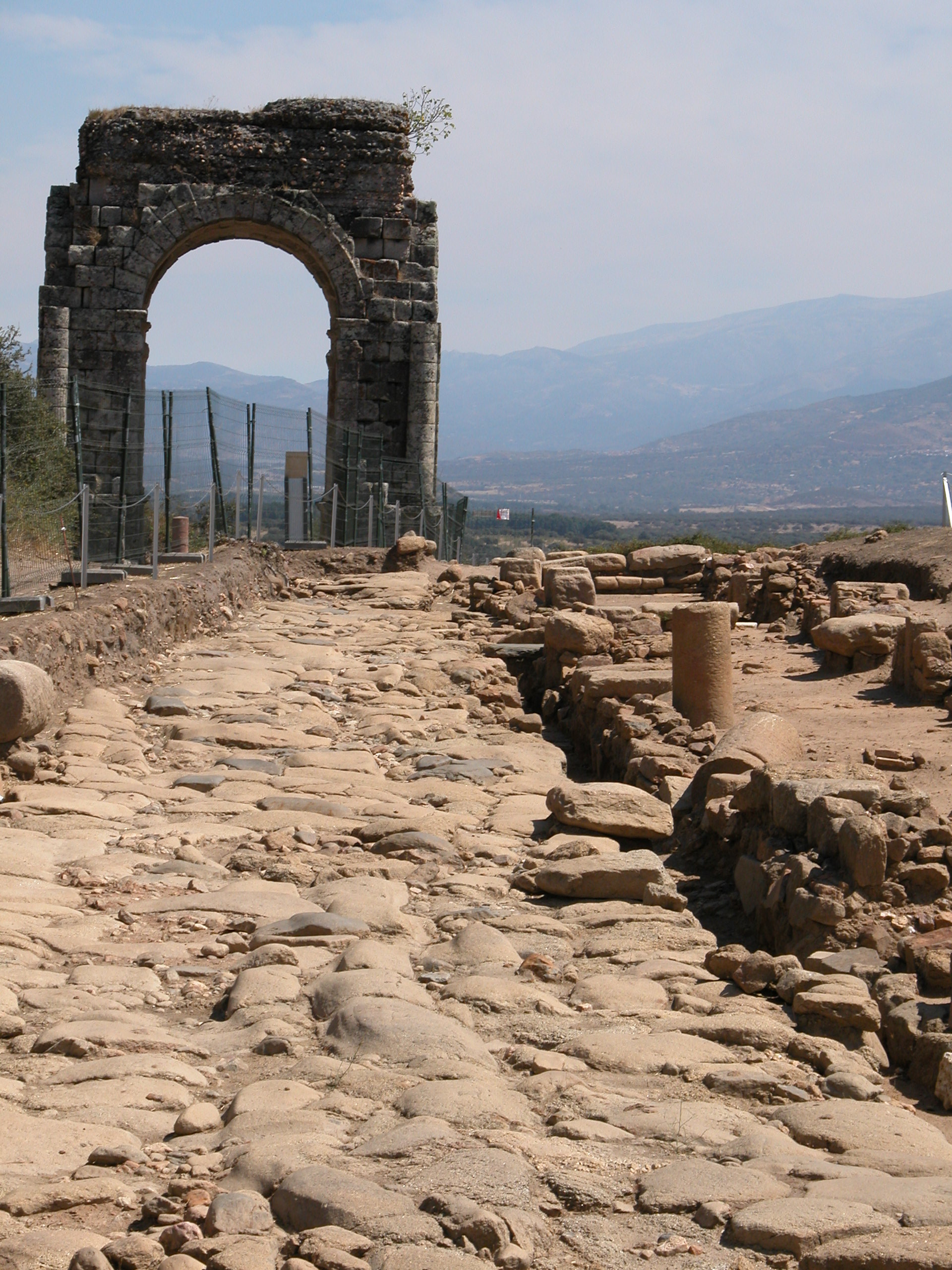
Capera
Guijo de Granadilla
Cáparra is the archaeological site of a Roman city straddling the boundary between the municipalities of Guijo de Granadilla and Oliva de Plasencia, in the province of Cáceres, Extremadura. The site is best known for its remarkably preserved four-arched triumphal gate, the tetrapylon, a unique monument of its kind on the entire Iberian Peninsula. Where does the name Cáparra come from? The name Cáparra, recorded in Latin as Capera, predates the Roman era and is linked to the Vettones, a Celtic-origin people who inhabited the area before Roman conquest. The settlement grew in importance because of its position on the Via de la Plata, the ancient route connecting the north and south of Hispania between Asturica Augusta (present-day Astorga) and Emerita Augusta (Mérida). In 74 AD, under Emperor Vespasian's edict granting Latin rights to the Hispanic provinces, Cáparra was elevated to the rank of municipium, marking a decisive step in its growth as an administrative and commercial center within the province of Lusitania. What remains can visitors see at the site today? Excavations at Cáparra have uncovered a central forum, a stretch of the original Via de la Plata roadway, public baths, gates in the city walls, and an amphitheater. A surviving section of the decumanus, the main east-west street, still shows traces of its ancient paving, flanked by the remains of porticoes and the facades of Roman houses. The forum itself consisted of a rectangular plaza bordered by a basilica, a curia, and three temples, forming the heart of the city's public life, with documented activity continuing until the third century AD. What makes Cáparra's arch so significant? The site's most iconic feature is the tetrapylon, a four-way triumphal arch standing precisely at the crossing point of the city's main streets. It is the only surviving structure of this type in present-day Spain, making it a landmark of national, not merely regional, importance. How is the Cáparra site set up for visitors? An Interpretation Center has been built near the archaeological area, where visitors can learn about the city's history, its development under Roman rule, and its role in trade and communication along the Via de la Plata. The exhibition helps put the layout of the ancient city into context before walking through the ruins themselves. Frequently asked questions Where exactly is Cáparra located? The ruins lie between the towns of Guijo de Granadilla and Oliva de Plasencia, in the province of Cáceres, in the Extremadura region of Spain. Why was Cáparra important in Roman times? The city thrived thanks to its location on the Via de la Plata, a key route linking the north and south of Hispania, and its status as a municipium, granted in 74 AD, strengthened its administrative role. What is the site's main attraction? The tetrapylon, a four-arched triumphal gate standing at the crossroads of the ancient city's main streets, unique on the Iberian Peninsula. Is there a visitor center on site? Yes, an Interpretation Center near the ruins provides background on the city's history and significance.
-
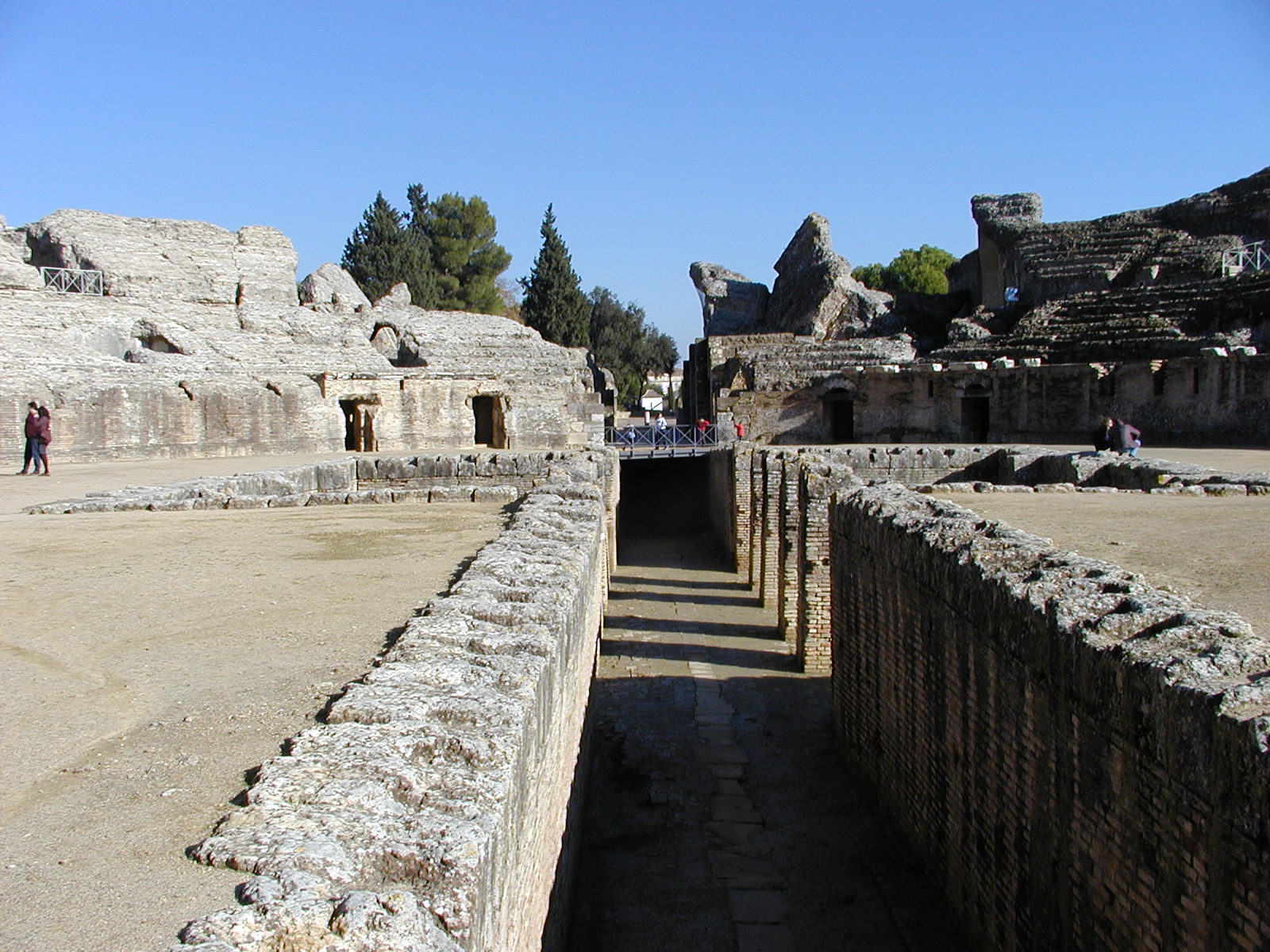
Italica
Santiponce
Italica is one of the most significant archaeological sites in Spain — the remains of an ancient Roman city founded in 206 BC by the general Scipio. The ruins lie within the modern municipality of Santiponce, just a short distance from Seville, and draw visitors interested in ancient Roman history and classical architecture. Why was Italica founded? The city was established as a settlement for veterans of the Second Punic War — soldiers of Italic origin who had fought under Scipio's command on the Iberian Peninsula. Its name reflects that origin, honoring the Italic settlers for whom the colonia was named. Over time the settlement grew, attracting further migrants from the Italian peninsula as well as the children of Roman soldiers and native women. Among the original Italic settlers were branches of the gens Ulpia, originating from the Umbrian town of Tuder, and the gens Aelia, from the city of Hadria — two families that would later prove extraordinarily significant to Roman history. What is Italica's connection to Roman emperors? Italica was the birthplace of Trajan, one of the most celebrated Roman emperors, who descended from the Ulpii. Hadrian, connected to the Aelii, was also raised in the city; Trajan later adopted him, and Hadrian succeeded him as emperor after his death. The fact that two consecutive rulers of the empire were tied to the same relatively modest provincial town makes Italica a place of exceptional historical significance — a rare case of a provincial colonia that produced not merely officials or officers, but the head of the Roman state itself, not once but twice in succession. Where exactly is Italica located? The archaeological site sits within the municipality of Santiponce, in the province of Seville, in the region of Andalusia, close to Seville itself. This location makes Italica easily accessible for visitors based in the Andalusian capital who want to take a short trip out of the city to see the remains of one of the more important centers of Roman Spain, then known as Hispania Baetica. What is Italica today? Today Italica functions as an archaeological site open to visitors. Those who come can explore the remnants of an ancient city that, for centuries, served as one of the centers of Roman administration and culture on the Iberian Peninsula. The site's historical weight — as the birthplace of two emperors and a striking example of Roman colonization in Hispania — continues to attract both scholars of ancient history and travelers seeking traces of the Roman presence on the Iberian Peninsula. Frequently asked questions When was Italica founded? The city was founded in 206 BC on the initiative of the Roman general Scipio. Who were Italica's first inhabitants? The first inhabitants were war veterans of Italic origin, later joined by further migrants from the Italian peninsula and by the descendants of Roman soldiers and local women. Which Roman emperors are connected to Italica? Emperor Trajan was born in Italica, and Hadrian, whom Trajan adopted, was raised there and later became emperor himself. Where is Italica located? The archaeological site lies within the municipality of Santiponce, in the province of Seville, close to the city of Seville itself. What is Italica today? It is an archaeological site open to the public, showcasing the remains of an ancient Roman city.
-
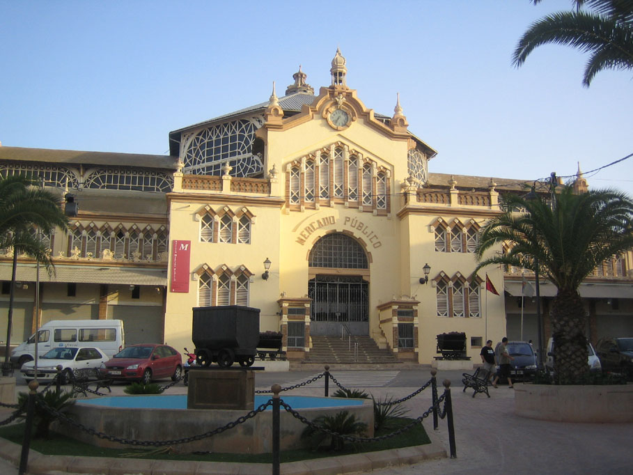
Mercado público de La Unión
La Unión
The Public Market of La Unión Mercado Público de La Unión is a former municipal market hall in La Unión, in the Region of Murcia, raised at the turn of the 20th century in the Spanish Modernist style. The building faces Plaza de Joaquín Costa, right at the center of a town whose fortune was built on silver and lead mining in the nearby Sierra Minera de Cartagena-La Unión. It now ranks among the most recognizable Modernist landmarks in the whole region. When was the market built, and who designed it? Architect Víctor Beltrí drew up the plans in 1903. Trained across a range of eclectic influences, Beltrí blended Mudejar touches with the Modernist vocabulary that was spreading through Spain at the time. Construction was overseen by Pedro Cerdán and finished in 1907. The finished hall quickly became a showcase for the wealth that mining had brought to La Unión at the turn of the century. What style is the building, and what is it made of? The market pairs stone, iron and glass in a way typical of European Modernist architecture from that era. Its floor plan follows a Latin cross with uneven arms, and an octagonal metal roof rises above the crossing, carried by an elegant cast-iron frame. Slender iron columns bear the weight of the whole structure, and nearly every opening in the walls was glazed to flood the interior with natural light. Alongside the Gran Hotel in nearby Cartagena, the market is regarded as one of the two most significant Modernist buildings anywhere in the Region of Murcia. What is the building used for today? Though it started life as an ordinary town market, the hall has hosted the International Festival of Cante de las Minas every year since 1978, the world's foremost festival of flamenco songs rooted in mining life. That pairing makes sense: La Unión spent a century as one of Spain's major mining centers, and the "cante minero" tradition grew directly out of the workers who toiled in the surrounding pits. Thanks to the festival, the old market turns each year into a stage that draws performers and audiences from around the world. Is the building protected as heritage? The market earned Bien de Interés Cultural (BIC) status, Spain's highest level of heritage protection, in 1975. That listing recognizes the building both as a landmark of Modernist architecture and as a record of the region's mining past. Frequently asked questions Where exactly is Mercado Público de La Unión located? It stands on Plaza de Joaquín Costa in the center of La Unión, in the Region of Murcia. Who designed the building? Architect Víctor Beltrí drew up the plans in 1903, with Pedro Cerdán overseeing construction. The work was completed in 1907. What architectural style does the market represent? It is a Modernist building combining stone, iron and glass, built on a Latin cross plan with an octagonal metal roof over the crossing. Is the building a protected heritage site? Yes, it has held Bien de Interés Cultural (BIC) status, Spain's top heritage designation, since 1975. What happens at the old market today? Since 1978 it has hosted the International Festival of Cante de las Minas, dedicated to flamenco songs about mining life.
-
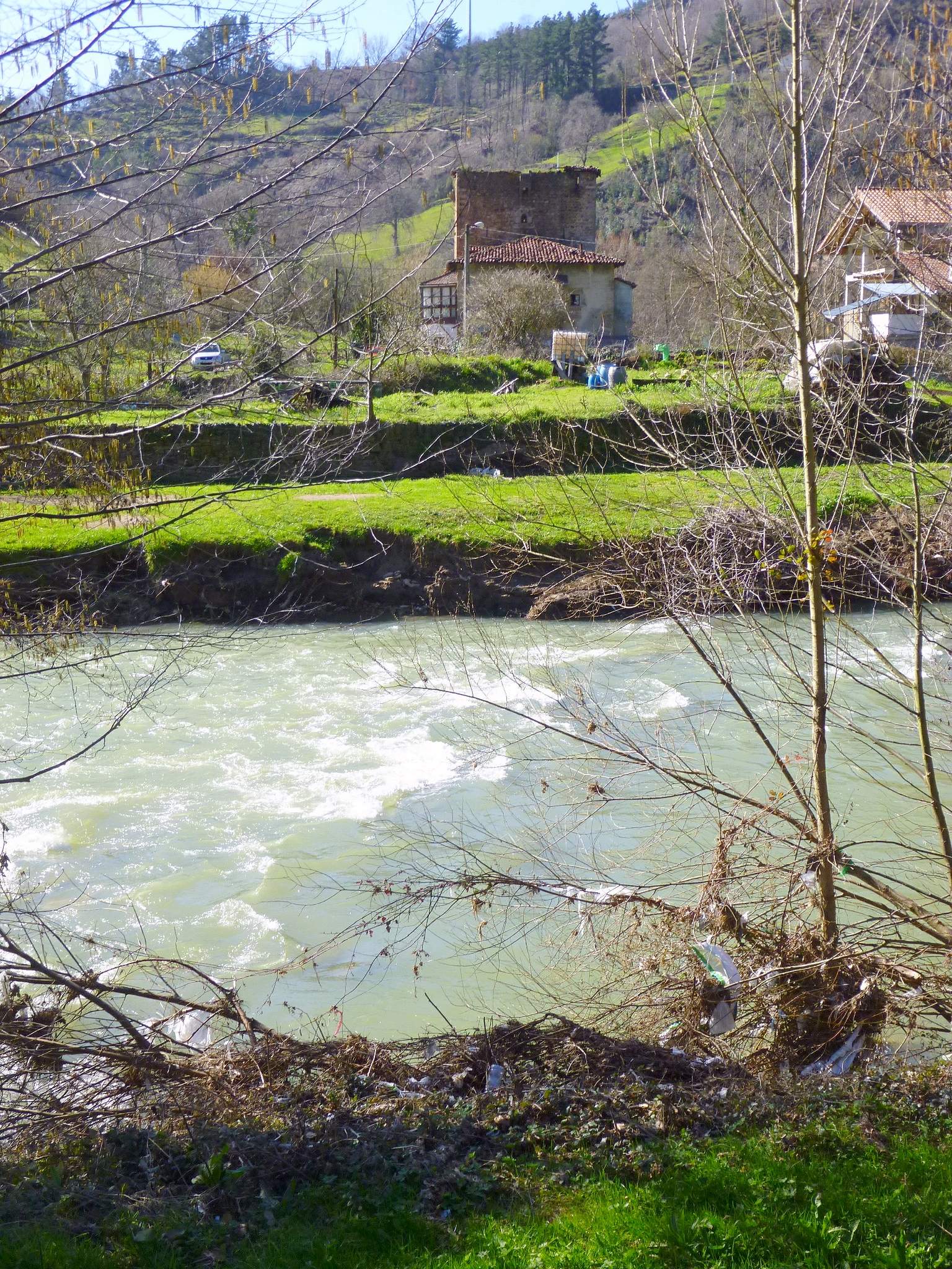
Terreros Dorrea
Zalla
Terreros Tower (Basque: Terreros Dorrea) is a 15th-century defensive tower in the La Herrera district of Zalla, in Spain's Basque Country. Raised by Juan Galíndez de Terreros, it counts among the best-preserved fortified towers in the Encartaciones region and is often singled out as a defining example of a Basque stronghold. Where does the tower stand? The tower rises in the barrio of La Herrera (La Herrera-Ijalde), part of the municipality of Zalla, within the Encartaciones (Enkarterri) comarca of Bizkaia province, a short distance from Bilbao. It stands in open countryside, on the opposite bank of the river from the hermitage of San Antonio de la Mella. Together with the neighbouring Urrutia Palace and that hermitage, it makes up what is known locally as the Monumental Complex of La Herrera, one of the municipality's most recognisable heritage groupings. What does it look like, and how old is it? Terreros Tower is a vertical structure raised on a square plan, standing roughly 15 metres tall. Its walls, around 1.2 metres thick, are built from dressed stone blocks, giving the tower the closed, massive silhouette typical of Basque defensive towers from an era of feuding between rival noble clans. The Basque word "dorrea" simply means "tower," so the name refers literally to the tower belonging to the Terreros family. How is the interior arranged? The floor layout reflects the building's original dual role as home and stronghold. The ground floor held a stable and storage space, and doubled at times as a makeshift jail. Above it, a residential floor reached via an outdoor stone staircase served as the family's main living quarters. Higher still sat a reception hall, with a bedroom occupying the topmost level. This progression — a working ground floor, externally reached living quarters, and increasingly formal upper rooms — is typical of the Basque tower houses (dorretxeak) that combined domestic life with defence. Why is it worth visiting? Terreros Tower is counted among the best-preserved defensive towers in Encartaciones, and it is often held up as a textbook example of a Basque fortified tower still standing today. Unlike many comparable towers in the region that have fallen into ruin, it retains its original compact form. Its closeness to the Urrutia Palace and the hermitage of San Antonio de la Mella makes it easy to combine into a single route through La Herrera's heritage sites, while Zalla itself makes a convenient base for exploring the wider Encartaciones region, not far from Bilbao. Frequently Asked Questions Who built Terreros Tower, and when? Juan Galíndez de Terreros had it raised in the 15th century. How big is the tower? It stands about 15 metres tall on a square plan, with stone-block walls roughly 1.2 metres thick. What does "dorrea" mean? It's the Basque word for "tower" — so Terreros Dorrea literally means the tower of the Terreros family. Is the tower an isolated site, or part of a wider group of monuments? Together with the Urrutia Palace and the hermitage of San Antonio de la Mella, it forms the so-called Monumental Complex of La Herrera in Zalla.
-
Torre Tolanca
Sonseca
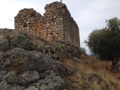
Torre Tolanca is a solitary watchtower of Muslim origin, standing on a small rocky rise in the municipality of Sonseca, in the province of Toledo. It belongs administratively to Sonseca, yet it sits well outside the town itself, isolated on high ground — a location that reveals its original purpose: watching the surrounding land and passing on warnings of danger. Where exactly does the tower stand? The tower is located roughly 3.5 kilometres southwest of Sonseca. It can be reached on foot from town along a route known as the Camino de la Estrella, which crosses the Montes de Toledo, the range of low, scrub-covered hills stretching south of the city of Toledo. The hilltop position is no accident: it commands a wide view over the surrounding countryside, and the tower itself stayed within sight of other fortified points in the region. An Andalusí origin Historians trace Torre Tolanca back to the 10th century, during the period of Muslim rule over this part of the Iberian Peninsula, known as al-Andalus. It was never an isolated post — it formed part of a wider network of lookout points scattered across the Montes de Toledo, built to protect the city of Toledo itself during the internal conflicts that troubled the region at the time. A network visible across the hills Towers of this kind depended on being seen from one another: a watchman stationed at one point needed a clear line of sight to signals from the next. From Torre Tolanca, the view takes in the castles of Almonacid, Mora, Orgaz, and Ventas con Peña Aguilera, confirming that it operated as one link in a coordinated chain of surveillance and territorial control. A Christian addition, then slow abandonment At some later point, a barbican was added onto the tower's eastern side — a small defensive structure shielding the main access point. Its construction style differs noticeably from the original tower walls, which points to a Christian-era build, likely in the 12th or 13th century, when the surrounding territory was being defended against Almohad and Almoravid incursions. The tower therefore kept its defensive role for several more centuries after it was first raised. That changed only once resettlement of the area gathered pace from the 14th century onward: as the frontier moved further south and the region stopped being a contested border zone, the tower lost its strategic purpose and was gradually left to decay. What survives today? The standing structure measures about 23 metres long, 9 metres wide, and 10 metres tall, though researchers believe it may originally have stood 4 to 5 metres taller before its upper section was lost. What remains today is the tower itself together with the attached barbican on its eastern flank. The site is listed under Spain's heritage protection rules, covered by the generic declaration from the decree of 22 April 1949 and by Law 16/1985 on Spanish Historical Heritage. Frequently Asked Questions Where is Torre Tolanca in relation to Sonseca? About 3.5 km southwest of the town centre, on a rocky rise within the Montes de Toledo. How do you get to the tower? On foot from Sonseca, following the Camino de la Estrella trail through the surrounding hills. How old is the tower? Its core dates to the 10th century, from the Muslim al-Andalus period; the barbican was added later, during the Christian era. What was it used for? It formed part of a chain of watchtowers guarding the approaches to Toledo, kept in visual contact with the castles of Almonacid, Mora, Orgaz, and Ventas con Peña Aguilera. Can visitors see the tower up close? It is a legally protected heritage site, accessible along the walking trail that leads out from Sonseca.
-
El Semàfor (la casa dels Senyals)
el Prat de Llobregat
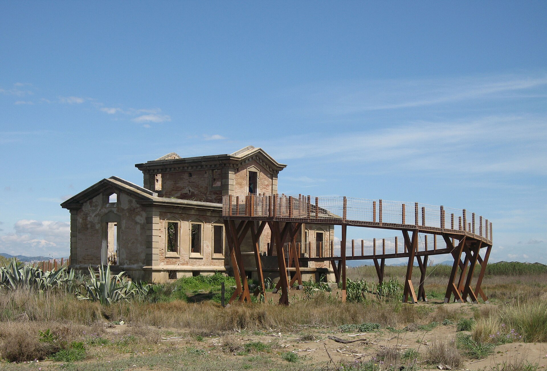
El Semàfor (la casa dels Senyals) is the ruin of a former signal station standing in the Llobregat Delta, within the town of el Prat de Llobregat, close to where the river meets the Mediterranean. The building dates from the second half of the 19th century and spent decades serving maritime communication — today it's a physical trace of an era when ships talked to the shore with flags and optical telegraphs rather than radio or satellite links. What was this building for? The station's official name was Semáforo del Río Llobregat. Its job was to regulate maritime traffic along the coast and cut down on accidents among ships heading toward the mouth of the Llobregat. It did this through a system of semaphores fitted with an optical telegraph: using a pre-arranged signal code, the station's crew could pass information to passing vessels about conditions near the river mouth and along the shoreline. Casa dels Senyals was also linked by signal to Montjuïc Castle in Barcelona, extending the chain of coastal observation posts further along the coast. How was the station built to survive on delta ground? The Llobregat Delta is low-lying land, regularly at risk from storm surges and high water. To keep the building safe, the ground beneath it was raised three metres above sea level before construction. The station itself had a rectangular floor plan with a lookout point at its centre, from which staff could keep watch over ship movements offshore. Underneath the building sat an underground cistern that collected rainwater — a common solution for isolated outposts where running drinking water wasn't available. What does El Semàfor look like today? The station stopped performing its original function long ago and now stands as a ruin. Even so, enough of its architectural form survives that it has been listed as a cultural asset within Catalonia's heritage register. It sits inside the Delta del Llobregat natural park, surrounded by the kind of landscape typical of a river delta — coastal dunes, scrubland and wetlands that today form an important nature conservation area, and that once made for a demanding, isolated posting for the people who staffed the signal station. Why is it worth a visit? El Semàfor isn't a conventional tourist attraction — there's no ticket booth or guided route. It appeals to visitors interested in maritime history and pre-radio communication engineering, as well as to anyone exploring the Llobregat Delta for its wildlife who wants to spot a trace of the coast's older infrastructure along the way. The ruined station, set against the delta landscape and the nearby sea, gives a sense of how 19th-century authorities managed shipping safety before modern technology existed. Frequently Asked Questions What was El Semàfor (casa dels Senyals)? It was a 19th-century signal station that used an optical telegraph and flag system to regulate ship traffic at the mouth of the Llobregat and to communicate with Montjuïc Castle. Can the building be visited today? It survives only as a ruin, standing within the Delta del Llobregat natural park — a remnant of historic infrastructure rather than a staffed attraction. Why was the ground under the building raised three metres? The Llobregat Delta sits at low elevation and is exposed to flooding from the sea, so the station's foundation was raised to protect the structure from water. Is El Semàfor a protected heritage site? Yes, the building is listed as a cultural asset in Catalonia's historic heritage register.
-
Sanisera
es Mercadal
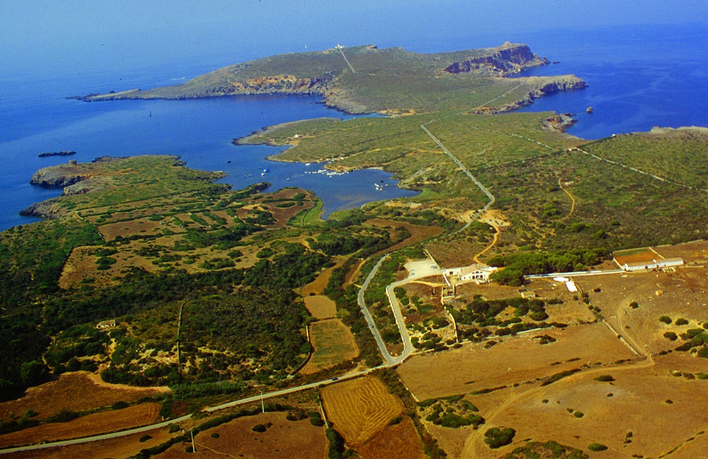
Sanisera is a Roman archaeological site on the bay of Puerto de Sanitja, in the municipality of Es Mercadal on Menorca — the only Roman town on the island where the ground has never been built over, leaving its full layout open to excavation. Where is Sanisera, and how does it differ from Menorca's other Roman towns? The site sits on a flat hilltop south of the port, rising between fifteen and twenty metres above sea level, right next to Cape Cavalleria on the island's north coast. Roman-era Menorca had three urban centres: Mago, Iamo and Sanisera. Mago and Iamo now sit under the present-day towns of Maó and Ciutadella, so large-scale digging there simply isn't possible. Sanisera was never resettled after antiquity, which is why it remains the one spot on the island where an entire former Roman town can be traced on the ground. How was the city founded, and who wrote about it? Roman legions under Quintus Caecilius Metellus conquered the Balearic Islands in 123 BCE, and the settlement by the Sanitja inlet was founded as a result of that campaign. The name Sanisera appears among the Balearic towns listed by Pliny the Elder in his Naturalis Historia (III, 77–78); Pliny, the Roman official who compiled that encyclopedic work, lived in the 1st century AD. The settlement itself was inhabited without interruption from the 1st century BC to roughly the 6th century AD, making it one of the longer-lived Roman sites on the island. What has excavation uncovered? Digs on the western side of the port have revealed a building that may have served an industrial or storage purpose, with signs of use running from the 1st century BC into late antiquity. The same area also turned up a structure holding graves, identified as a Paleochristian basilica along with its adjoining cemetery. These finds show that life at Sanisera didn't end with Roman administration — it continued into the early centuries of Christianity on the island. How do you visit, and how long does it take? Sanisera today shows the remains of a Roman military camp (castellum) plus the western sector of the old town, with its building and cemetery, and the whole area is covered on foot. Walking the site typically takes around two hours. Es Mercadal makes the most convenient base, roughly fifteen kilometres away by road, and the village of Fornells lies just a few kilometres from the Sanitja bay. Frequently asked questions What is Sanisera? A Roman archaeological site on the bay of Puerto de Sanitja in Menorca, the only Roman town on the island open to excavation across its whole footprint. When was the town founded? It was established after the Roman conquest of the Balearic Islands in 123 BCE, led by Quintus Caecilius Metellus. Who mentioned Sanisera in ancient sources? Pliny the Elder lists it among the Balearic towns in his Naturalis Historia (III, 77–78). What can you see on site? The remains of a Roman military camp, a building of probable industrial use, and a Paleochristian basilica with its cemetery on the western side of the port. How do you get to Sanisera? The site lies about fifteen kilometres by road from Es Mercadal, near the bay of Fornells on Menorca's north coast.
-
Torre de Cala Salionç
Tossa de Mar
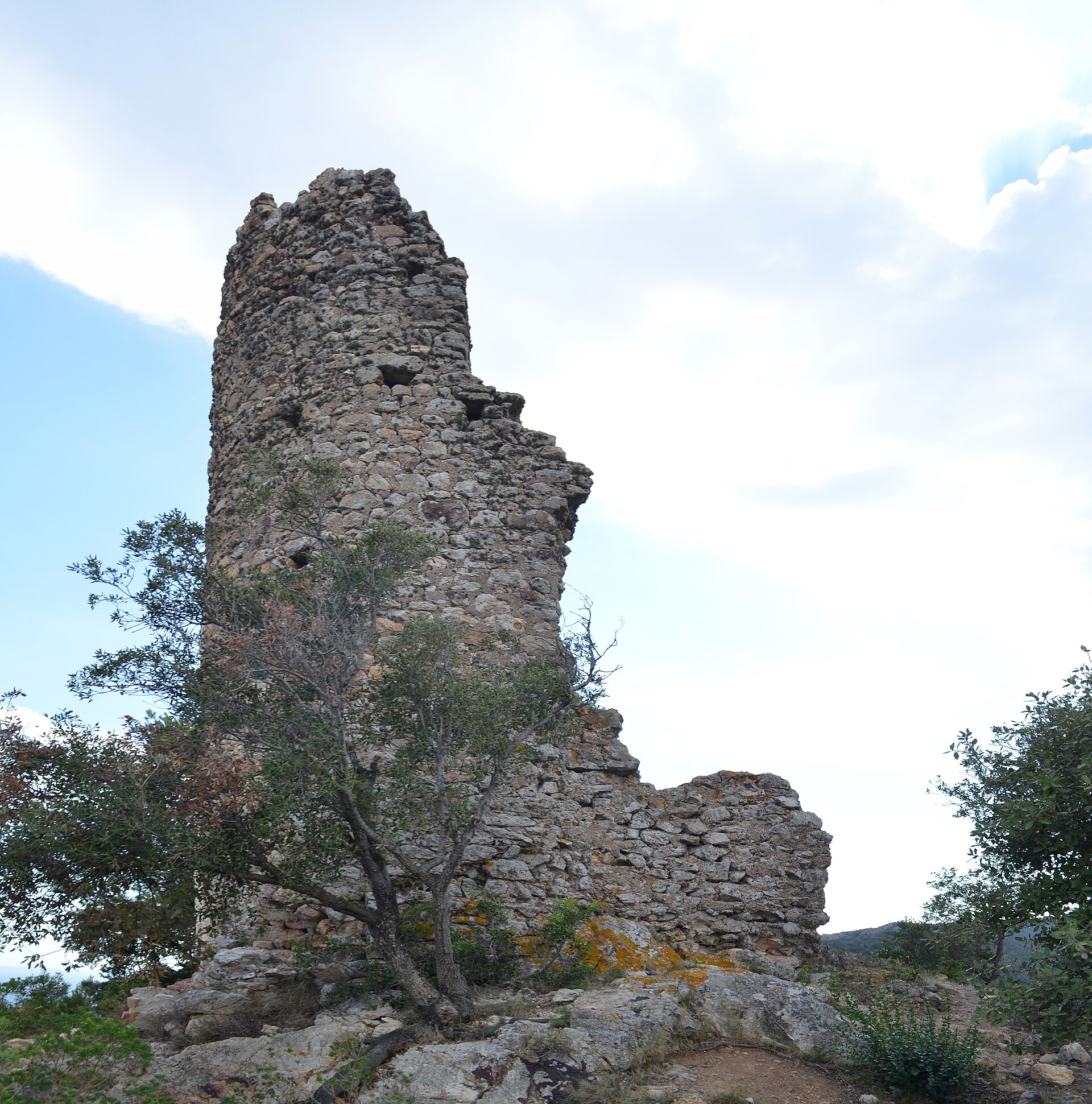
Torre de Cala Salionç is a stone watchtower perched on the rocky Pola headland above the coastline of Tossa de Mar, on the Costa Brava. Also known as Agulla de Pola, it once formed part of a chain of coastal lookout posts guarding the Girona shoreline, and its ruins still stand today as a marker of the area's medieval defensive past. Where is Torre de Cala Salionç located? The tower sits within the municipality of Tossa de Mar, in the La Selva comarca of Girona province, on Catalonia's Costa Brava. It occupies the summit of the Pola headland, at roughly 41.734°N, 2.953°E, a vantage point with open views over the sea and along the coast toward Sant Feliu de Guíxols and Lloret de Mar. How old is the tower? Defensive structures on the Pola rock are recorded as far back as the year 966, making this one of the older fortified points on this stretch of coast. The semicircular tower visible today dates from the 16th century and was built directly on top of an earlier, square-plan fortification from around the mid-10th century. A document from 1218 refers to the site as "puig de Guàrdia Pola," confirming that it kept its watch-post role for centuries. What was its role in the coastal defense network? Torre de Cala Salionç kept direct visual contact with Tossa Castle, whose tower today serves as a lighthouse. It formed part of a wider signaling chain along the Girona coast that included the Sant Joan tower in Lloret de Mar, documented since 1079, and the Sant Joan tower in Blanes, documented since 1001. Together, these towers relayed signals from one lookout point to the next along the shoreline. What remains on site today? What survives is the stone base of a semicircular tower with a small frontal projection, the 16th-century layer of construction, sitting above the remains of the older, square 10th-century structure beneath it. The headland itself also serves an official modern function: the Catalan Cartographic Institute (Institut Cartogràfic de Catalunya) uses the site as a geodetic survey marker, registered under number 308-109-017. Is the tower a protected heritage site? Yes. Torre de Cala Salionç is listed in the Inventory of Architectural Heritage of Catalonia (Inventari del Patrimoni Arquitectònic de Catalunya) under reference 33515, and it also appears in the region's archaeological heritage inventory under ID 2251, recognizing it as part of Catalonia's cultural heritage. Frequently Asked Questions Where does the name Agulla de Pola come from? It is an alternative name for the tower, used for instance in German-language references and on Wikimedia Commons, referring to the rocky Pola headland the structure stands on. How old is the tower exactly? The upper, semicircular section dates from the 16th century, but it was built over an older defensive structure from around the mid-10th century — the first record of fortifications on this spot goes back to 966. What did the tower have visual contact with? It communicated directly with Tossa Castle, now a lighthouse, and with other coastal watchtowers such as those in Lloret de Mar and Blanes. Is the site legally protected? Yes, it is registered in Catalonia's Inventory of Architectural Heritage and in the regional archaeological heritage record. What is the site used for today? The Pola headland where the tower stands now functions as an official geodetic survey marker maintained by the Catalan Cartographic Institute.
-
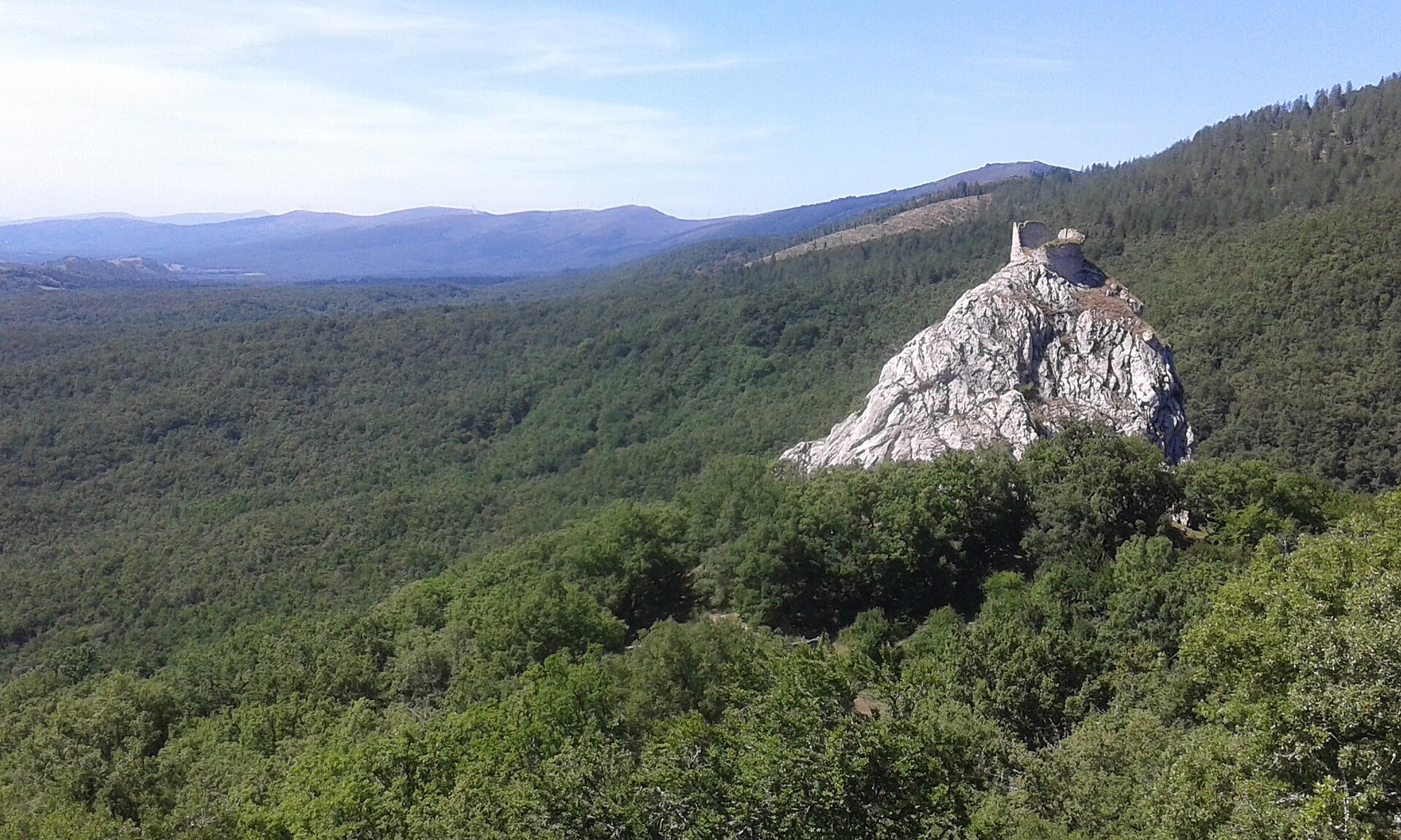
Castle of Marutegi
Araia
Castillo de Marutegi is a medieval hilltop fortress above the village of Araia, in the municipality of Asparrena, Álava province, in the Basque Country. Its ruins crown a rocky ridge of the Sierra de Altzania at roughly 860–870 metres above sea level, less than two kilometres northwest of the village. Why was the castle built on this particular peak? The summit commands the eastern edge of the Llanada Alavesa plain and the approach into Navarre through the San Adrián pass and the Arakil-Burunda corridor. From here, defenders could watch the old route running from San Adrián through Araia toward Salvatierra/Agurain — one of the key links between Álava and Gipuzkoa. The choice of site was deliberate: the fortress worked as a border watchpost between the kingdoms of Navarre and Castile. When was Marutegi actually built? Local tradition credits the 8th-century Navarrese king García Íñiguez with founding a stronghold here. Excavations carried out in June 2020 by the Basque government's Centro de Patrimonio Cultural Vasco, led by José Luis Solaun Bustinza and Ángel Martínez, point to a later date for the standing remains: the walls visible today were raised between the second half of the 12th century and the first half of the 13th. Archaeologists identified four separate building and occupation phases. The earliest written record of the castle dates from 1362, and later boundary documents between Araia and Zalduendo refer to it as "castillo de Araya." The fortress was reworked again during the 13th to 15th centuries before being abandoned in the late 15th or early 16th century and falling into ruin shortly afterward. What survives on site today? The best-preserved feature is the tower, built on a roughly D-shaped floor plan measuring about 10.5 by 9 metres; sections of its western wall still stand 7 metres high. Wall thickness varies sharply — from 2.7 metres on the curved eastern face down to just 0.65 metres near the top of the western side. Below the tower, a lower enclosure roughly 31 metres long and 12 metres deep, bounded by a 1.5-metre perimeter wall, once held a guardhouse and auxiliary rooms. Access to the upper platform is through a narrow southern opening, and the final 50-metre approach is steep and demands care. Centuries of stone-robbing after the castle's abandonment stripped most of the lower defences, so today only the tower gives a real sense of the original structure. How do visitors reach the castle? The walk starts in Araia, near the site of the former Ajuria factory, where parking is available. A waymarked trail leads from there to the base of the crag, though the last stretch up to the tower itself is noticeably steeper than the rest of the route. Marutegi ranks among the few medieval castles still standing in the Basque Country, alongside Castillo de Portilla, which keeps it on the radar of hikers and history enthusiasts alike. Since July 2021, the Basque Government has protected it as an archaeological zone under special protection, and each September the people of Araia hold the "Día del Castillo de Marutegi," a communal walk to the ruins with a talk and live music. Frequently Asked Questions How high up is Castillo de Marutegi? The ruins sit at roughly 860–870 metres above sea level on a ridge of the Sierra de Altzania. How long is the hike from Araia? The route begins near the former Ajuria factory and follows a short waymarked trail; the final climb below the tower is steep and requires caution. Is the castle officially protected? Yes. Since July 2021 the Basque Government has classified it as an archaeological zone under special protection. What remains of the original castle? Mainly the D-shaped tower and fragments of the lower perimeter wall; the rest was destroyed after the site was abandoned.
-
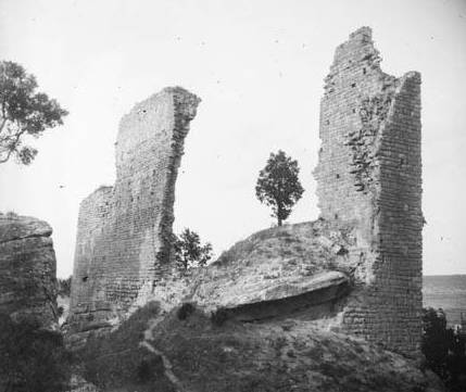
Casal de Bellpuig
Sant Julià de Vilatorta
Casal de Bellpuig is the ruin of a medieval fortified manor house in Sant Julià de Vilatorta, a small town in the Osona comarca, right in the middle of Catalonia's Plana de Vic. Only fragments of its walls survive today, but the site still draws visitors interested in the region's feudal past and in the view from its hilltop position. Where are the ruins located? Casal de Bellpuig sits on a small hill (puig in Catalan) overlooking the Noguera stream, close to the Park of the Seven Springs (Parc de les 7 Fonts). From here the view stretches across Sant Julià de Vilatorta and the whole Vic plain, which explains why medieval builders picked this exact spot — it let them watch over the surrounding land and spot any threat from a distance. A gentle walking path leads up to the ruins, and the full round trip covers a little over 2 kilometers, so a visit doesn't require any special hiking gear or fitness. What is the history behind the site? The oldest surviving document mentioning Bellpuig dates to 1147 and describes it as a fortified residence dependent on the nearby castle of Sameda (Meda). Since no earlier record of a castle at this spot survives from the 11th or 12th century, historians place the construction of the building at the turn of the 12th and 13th centuries. Its first known owners were knights bearing the surname Bellpuig, who served as castellans of Meda castle and answered to the bishops of Vic as their feudal lords. By the mid-13th century, the family had merged through marriage with the powerful Centelles lineage, a link confirmed in a 1327 document issued under King James II, which names Eimeric, son of Elisenda, as holding authority over the house of Centelles, the castle of Meda, and Bellpuig together. It is from this period that the earliest records appear linking the name of the town, Vilatorta, with Bellpuig — recorded at the time as "Pulcho Podio." Why is only a ruin left today? The building's fate was sealed by the Catalan Civil War (1462–1472): around 1470, Casal de Bellpuig was destroyed and it was never rebuilt afterward. Only two sections of wall from the original Romanesque manor have survived to the present day, though they remain substantial enough to give a sense of the scale of the original structure. The rest of the building gradually crumbled over the following centuries, leaving behind a stone skeleton now folded into the hillside landscape. Is it worth planning a visit? Casal de Bellpuig is listed as a cultural asset of national interest, a status that reflects its historical value despite the modest amount of masonry that remains standing. The site appeals most to visitors who enjoy combining a short walk with a rewarding view — the brief climb up the hill is repaid with a panorama over the Plana de Vic and the quiet green surroundings of the Seven Springs Park. It pairs well with a visit to Sant Julià de Vilatorta itself, a town known for its Modernista architecture and long-standing craft traditions. Frequently asked questions What was Casal de Bellpuig originally? It was a medieval fortified manor house whose first owners served as castellans of the nearby Meda castle and answered to the bishops of Vic. When was it built and when was it destroyed? The earliest record dates to 1147, and the structure itself is generally dated to the turn of the 12th and 13th centuries. It was destroyed around 1470 during the Catalan Civil War and was never rebuilt. What can visitors see on site today? Only two sections of wall from the original Romanesque manor house survive, set on a hilltop with views over the surrounding countryside. How do you get to the ruins? An easy, well-marked walking path near the Park of the Seven Springs leads to the site, with a round trip of about 2 kilometers.
-
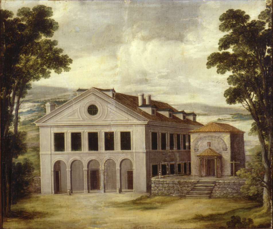
Casa real de Monesterio
San Lorenzo de El Escorial
Casa Real de Monesterio is the ruined 17th-century royal service house in San Lorenzo de El Escorial, near Madrid, built to support the vast royal hunting grounds that Philip II and Philip III laid out around the Escorial monastery. Where is the Casa Real de Monesterio? The ruins stand within the former "Gran Cerca de Felipe II," the great walled hunting estate King Philip II established around the monastery he was building at San Lorenzo. Together with the neighboring tracts of La Herrería, La Fresneda, and El Campillo, the Monesterio lands were meant to supply the needs of the monastery's monks and the royal court. Today the ruins sit in a quiet, partly wooded stretch at the foot of the Sierra de Guadarrama, a short distance from the town centre and the monastery-palace that gives the area its fame. Where does the name come from, and what is the site's history? The name Monesterio already appears in the medieval "Libro de la Montería" of Alfonso XI, which singles out the area as prime hunting ground. In 1504, the Catholic Monarchs issued decrees regulating the fencing of this land, showing its importance even before the Escorial was built. When Philip II began construction of the monastery dedicated to San Lorenzo in 1561, he bought up further neighboring estates, including Monesterio, to secure supplies and support for the Hieronymite monks and the court. In 1594, he ordered the depopulation of Monesterio and the adjoining Campillo, turning both into a royal hunting forest and monastic pastureland later known as "Los bosques de Su Majestad" — His Majesty's forests. The building whose ruins survive today, however, dates from later. It was built between 1611 and 1613 under Philip III. The royal architect Juan Gómez de Mora designed it as a "casa de oficios," a service house supporting the surrounding hunting grounds and pastures. The original plans are preserved in the Vatican Library. Construction was plain but solid, originally roofed in slate and later covered with curved tile. What can visitors see today? After the Madoz disentailment law secularized church property in 1869, the estate passed into private hands. The building gradually fell into disrepair: it has lost its roof, and one wall has collapsed from long neglect, though the chimneys of the old service house are still recognizable. Consolidation work in 2016 halted further deterioration of the remaining walls. Locally, the building is known as "la casa de las cigüeñas," the house of the storks, for the birds that nest on its ruins. The site holds Bien de Interés Cultural (BIC) protected status, and from October 25, 2013, to April 26, 2018, it appeared on Hispania Nostra's Red List of endangered Spanish heritage sites. When is the best time to visit the area? The former royal hunting grounds are most pleasant to explore in spring and autumn, when temperatures in the Sierra de Guadarrama are mild and visibility is at its best. Since the property remains in private hands, access to the ruins themselves can be limited, so it is worth checking current local conditions before planning a visit. A trip here pairs naturally with a visit to the nearby Real Monasterio de San Lorenzo de El Escorial and walks through the surrounding woodland of the old Cerca de Felipe II. Frequently asked questions What was the Casa Real de Monesterio originally used for? It was a service house (casa de oficios) built between 1611 and 1613 for Philip III, supporting the royal hunting grounds around the Escorial. Why is the building nicknamed the "house of storks"? Because storks nest on the ruins — the local name "casa de las cigüeñas" has stuck among residents of the area. Is the site protected today? Yes, it holds Bien de Interés Cultural status, and between 2013 and 2018 it was listed on Hispania Nostra's Red List as an endangered monument. Can visitors tour the Monesterio ruins? The land belongs to a private estate, so access can be limited — it's best to check current conditions locally before visiting.
-
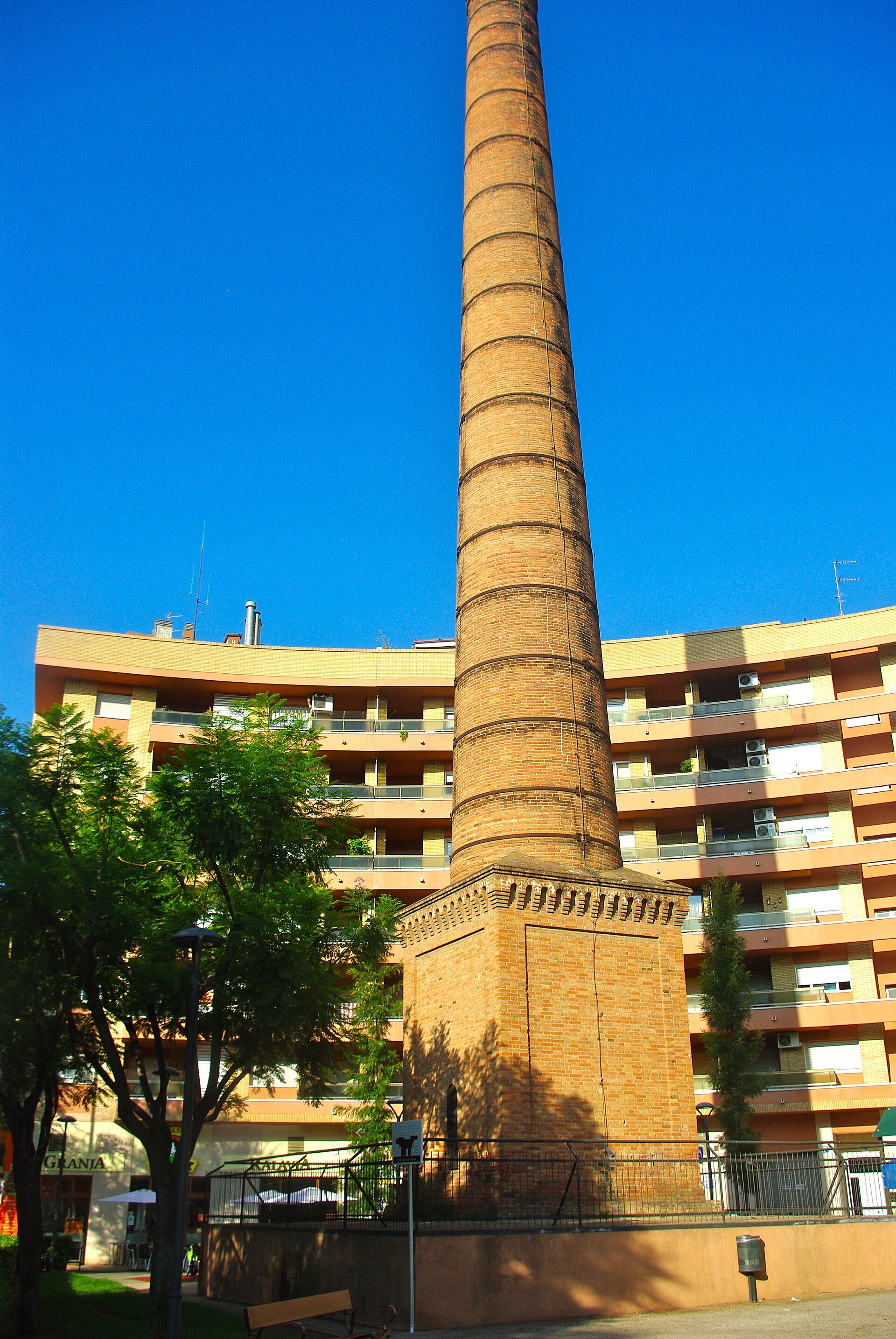
Fumera del Gas Reusense
Reus
Fumera del Gas Reusense is a 19th-century industrial chimney in Reus, a city in the province of Tarragona, in Catalonia's Baix Camp region. This tall brick tower is the only surviving trace of the old "Gas Reusense" gasworks, which supplied the city with gas, and later electricity, for over a century. What exactly is a "fumera"? In the local Reus dialect, "fumera" simply means a factory chimney — and this particular one, standing on Marià Fortuny avenue, is now the sole physical reminder of an entire industrial complex. Once the gasworks shut down and its production buildings were demolished, the chimney was left standing as a landmark and a memory of the city's industrial past. It is listed in the Inventory of Architectural Heritage of Catalonia (Inventari del Patrimoni Arquitectònic de Catalunya), confirming its recognized historical value. What does the chimney look like? The fumera rests on a square base with a small entrance door and decorative brickwork at the bottom. Above the base rises a long cylindrical shaft that gradually narrows with height — a common design in 19th-century industrial chimneys, meant to improve draught. The structure is reinforced by roughly a dozen metal rings spaced along its length, which kept the brickwork from cracking under thermal stress. The entire chimney is built of exposed, unplastered brick, so visitors can still appreciate the bricklaying craftsmanship of the period. The story of Gas Reusense The Gas Reusense company was founded on 29 May 1854 as a private venture, with industrialist Macià Vila as its first president. Its original purpose was to take over the municipal concession for public lighting, replacing oil lamps with gas street lighting. Gas supply later expanded to private households across Reus, used for heating and cooking. Toward the end of the 19th century, the company also began generating electricity at the same site, but growing competition forced it to abandon that business in the early 20th century. Gas Reusense continued operating independently until 1969, when it was absorbed by Catalana de Gas y Electricidad, the company that took over most local gasworks across the region. Why visit the fumera? The Gas Reusense chimney is a small but telling piece of Catalan industrial heritage, a reminder of the era when cities like Reus built their own energy infrastructure almost from scratch. For visitors, it's a modest yet distinctive landmark that ties together the city's economic history and its industrial architecture. Standing among modern buildings, the chimney's 19th-century form stands out by contrast, and it's an easy stop to add to a walk around the city. Frequently asked questions What is a "fumera"? "Fumera" is the local Reus term for a factory chimney. The Fumera del Gas Reusense is the surviving chimney of the city's former gasworks — the only element left of the whole plant. When was the chimney built? It was built in the late 19th century, during the growth of the Gas Reusense company, which had been founded in 1854. What happened to the rest of the factory? The production buildings were demolished, leaving the chimney as the only trace of the former gasworks. Is the chimney a protected heritage site? Yes, it is listed in the Inventory of Architectural Heritage of Catalonia, confirming its status as a protected monument.
-
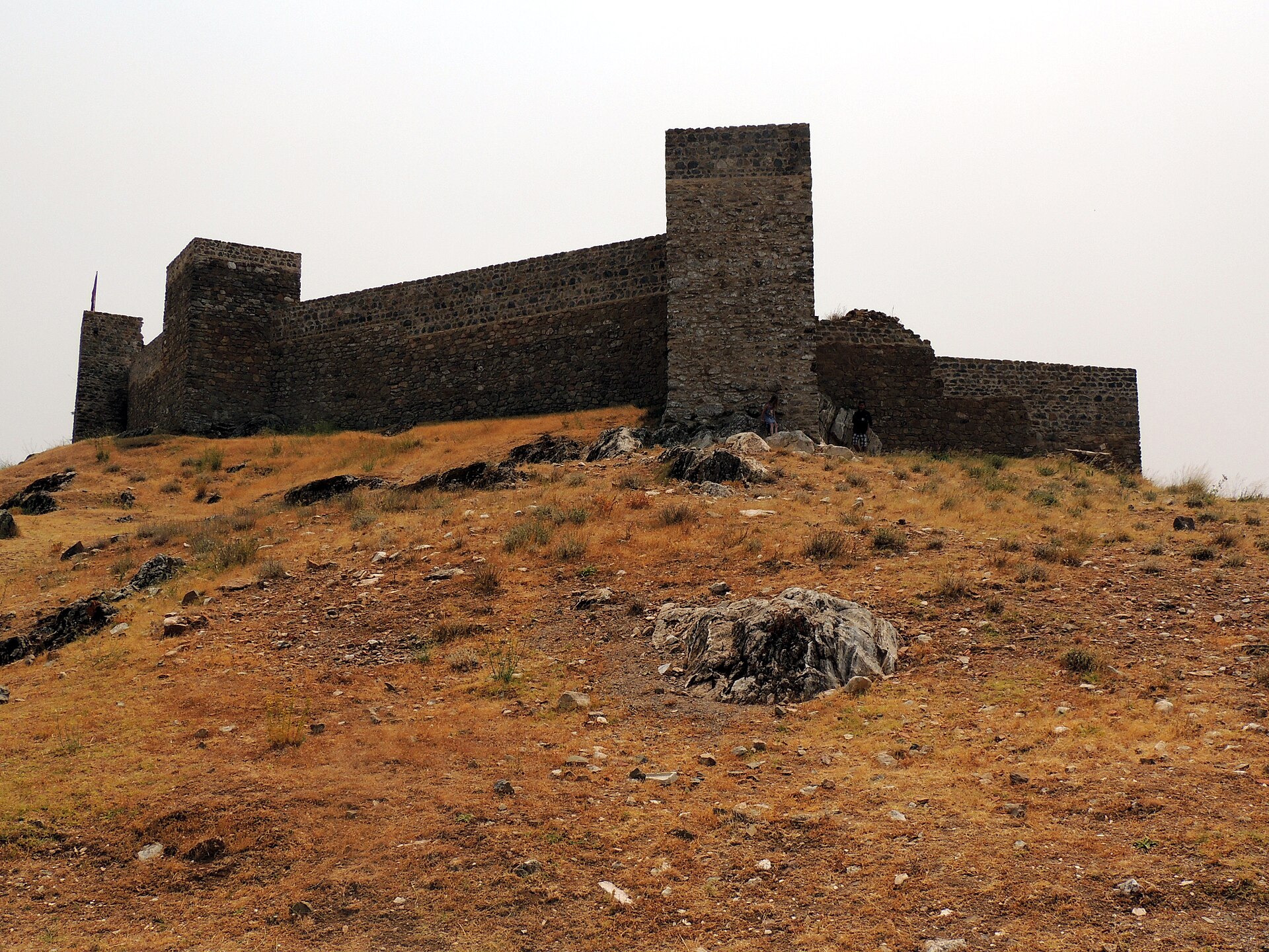
Castillo de Aracena
Aracena
Castillo de Aracena stands on a hilltop above the town of Aracena, in the province of Huelva, right in the heart of the Sierra de Aracena y Picos de Aroche. Together with the church beside it, the fortress forms the town's best-known skyline and ranks among the must-see stops in the region. How do you get to the castle? The castle crowns the hill at the very center of town, so the climb from the main square or Plaza San Pedro takes only a short walk up narrow old-town lanes. In summer, when the heat makes the uphill stretch less appealing, a tourist train runs from Plaza San Pedro straight to the walls. Aracena sits roughly 90 km north of Seville and is easily reached along the N-433 road, so arriving by car is the most practical option — park in the lower part of town and continue on foot from there. What will you see once you're up there? The structure standing today was raised in the mid-13th century, after the Christian conquest of the area, most likely on the remains of an earlier Muslim stronghold — excavations point to two separate occupation periods, one from the 10th to 11th centuries under the Caliphate of Córdoba and the Taifa of Seville, and another from the 12th to the mid-13th century under Almoravid and Almohad rule. The fortress was laid out around a patio de armas, a parade yard, and an alcázar, divided by a defensive wall; the best-preserved feature today is the Torre Mayor, its main tower. The castle stayed in military use until the early 16th century, and since 1949 it has held the status of Bien de Interés Cultural, Spain's designation for a protected historic monument. Right beside the walls stands the Iglesia Prioral de Nuestra Señora del Mayor Dolor, a Gothic-Mudéjar church built between the 13th and 15th centuries under the patronage of the Order of the Temple, to whom the Crown of Castile had granted Aracena. Its tower is decorated with sebka latticework clearly inspired by Seville's Giralda, and inside, three naves of equal height run the length of the building. The church has been listed as a historic-artistic monument since 1995. From the walls and the open yard, the view stretches over Aracena's rooftops and the rolling hills of the Sierra — reason enough on its own for many visitors to make the climb, and this outer area can be explored freely, without a ticket. When should you visit, and what does it cost? Access inside the walls requires a ticket and is limited to Saturdays, Sundays, and public holidays, from 12:00 to 14:30 and 16:00 to 18:30 — it's worth checking the current schedule before you go, since hours are occasionally adjusted seasonally. A standard ticket costs around €2.50, with a reduced rate of about €1 for seniors over 65, visitors with a disability of 33% or more, and children aged 6 to 12. Tickets are often bundled with entry to the nearby Gruta de las Maravillas, a well-known show cave, letting you combine both sights on one pass. Early morning or late afternoon tends to be the best time to come, when the sun sits lower and the light works better on the stone walls and the view below. Frequently asked questions Is it free to walk up to the castle hill? Yes — strolling the grounds around the walls and taking in the view over town costs nothing; the fee applies only to entering the castle ruins themselves. Can a visit be combined with the Gruta de las Maravillas? Yes, tickets for both attractions are often sold together, making it easy to plan a single day around them. Is the castle accessible for visitors with limited mobility? The approach runs up steep, cobbled lanes, and the ruins themselves sit on uneven ground, so the climb can be demanding for anyone with reduced mobility. Is there anything worth seeing besides the castle itself? Right next to the walls stands the Iglesia Prioral, easily recognized by its Mudéjar-style tower — a natural extension of the same visit.
-
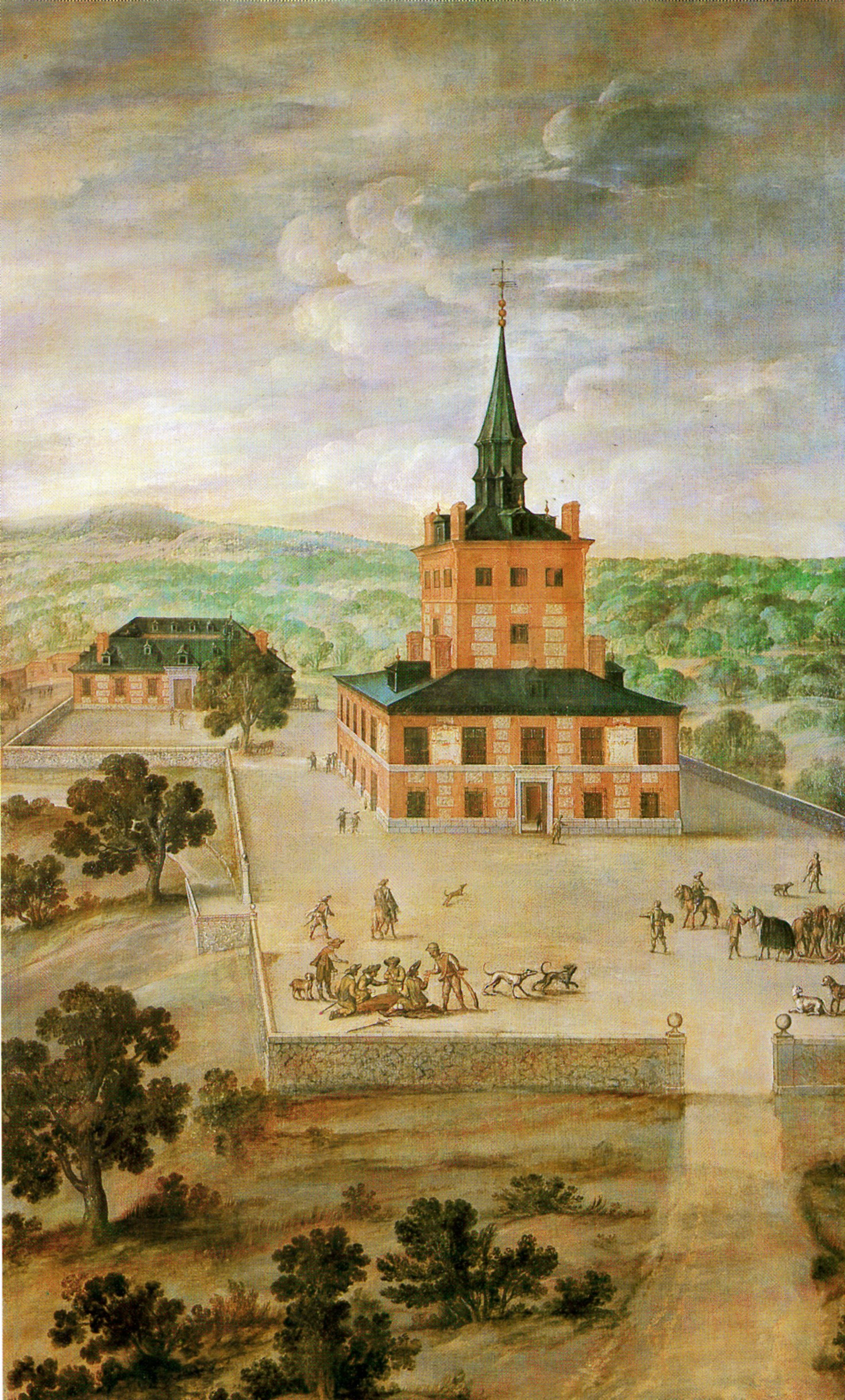
Torre de la Parada
Madryt
Torre de la Parada is a former royal hunting lodge whose ruins lie today in the forests on the outskirts of Madrid, in the Fuencarral-El Pardo district. What was Torre de la Parada? Built as a 16th-century baroque pavilion with a tower — the Spanish word "torre" simply means tower — the building served the kings of Spain and their retinue as a resting point during hunts in the woodlands surrounding the Royal Palace of El Pardo, at the foot of the Sierra de Guadarrama. Its rooms were once hung with numerous paintings by Spanish and Flemish artists. Most of these works now hang in Madrid's Prado Museum, which makes Torre de la Parada a small but significant chapter in the story of one of the world's greatest painting collections. How do you get there? The ruins stand within present-day Monte de El Pardo, a large forested estate in the Fuencarral-El Pardo district, a few kilometres northwest of central Madrid. The Royal Palace of El Pardo is the easiest landmark to use when planning a route, whether on foot or by car, into the surrounding woods. Because the area functions partly as protected woodland and former royal hunting ground, it is worth checking current access rules before setting out. What is the history behind it? Torre de la Parada did not survive intact. During the War of the Spanish Succession the lodge was first plundered, and in 1714, when Austrian troops took the area, it was largely destroyed by fire. Only ruins remain today, a quiet trace of what was once a hunting residence of the Spanish Habsburgs. The war itself (1701–1714) reshaped the Spanish crown, ending with the Bourbon dynasty on the throne — a conflict whose reach extended even into the woods of El Pardo, consuming a royal pavilion that had once witnessed the court at its height. What is left to see today? Visitors today will mainly find the ruins of the old pavilion — remnants of walls and the outline of the tower, set among the dense oak forest typical of Monte de El Pardo. This is a site for those drawn to art history and the residential architecture of the Spanish Habsburgs rather than a polished tourist stop with visitor facilities. The real complement to a visit is a trip to the Prado, where the paintings that once decorated Torre de la Parada now hang — the best way to picture the lodge in its heyday. When is the best time to visit? Given the forested setting, spring and autumn are the most comfortable seasons, avoiding Madrid's peak summer heat. Morning visits are recommended, when the woods of El Pardo are quietest and the light falls well on the ruins and surrounding landscape. Frequently Asked Questions What was Torre de la Parada used for? It was a baroque hunting lodge built for the kings of Spain, used as a resting place during hunts in the forests around El Pardo. Why does Torre de la Parada matter for art history? Because the paintings by Spanish and Flemish masters that once decorated it are now mostly held in the Prado Museum, forming part of one of the world's most important art collections. What happened to the original building? It was plundered during the War of the Spanish Succession and largely destroyed by fire in 1714 after Austrian troops occupied the area. Only ruins survive today. Can you visit the ruins today? The site lies within the Monte de El Pardo woodland, an area with partial access restrictions, so it is worth confirming current entry rules before planning a visit.
-
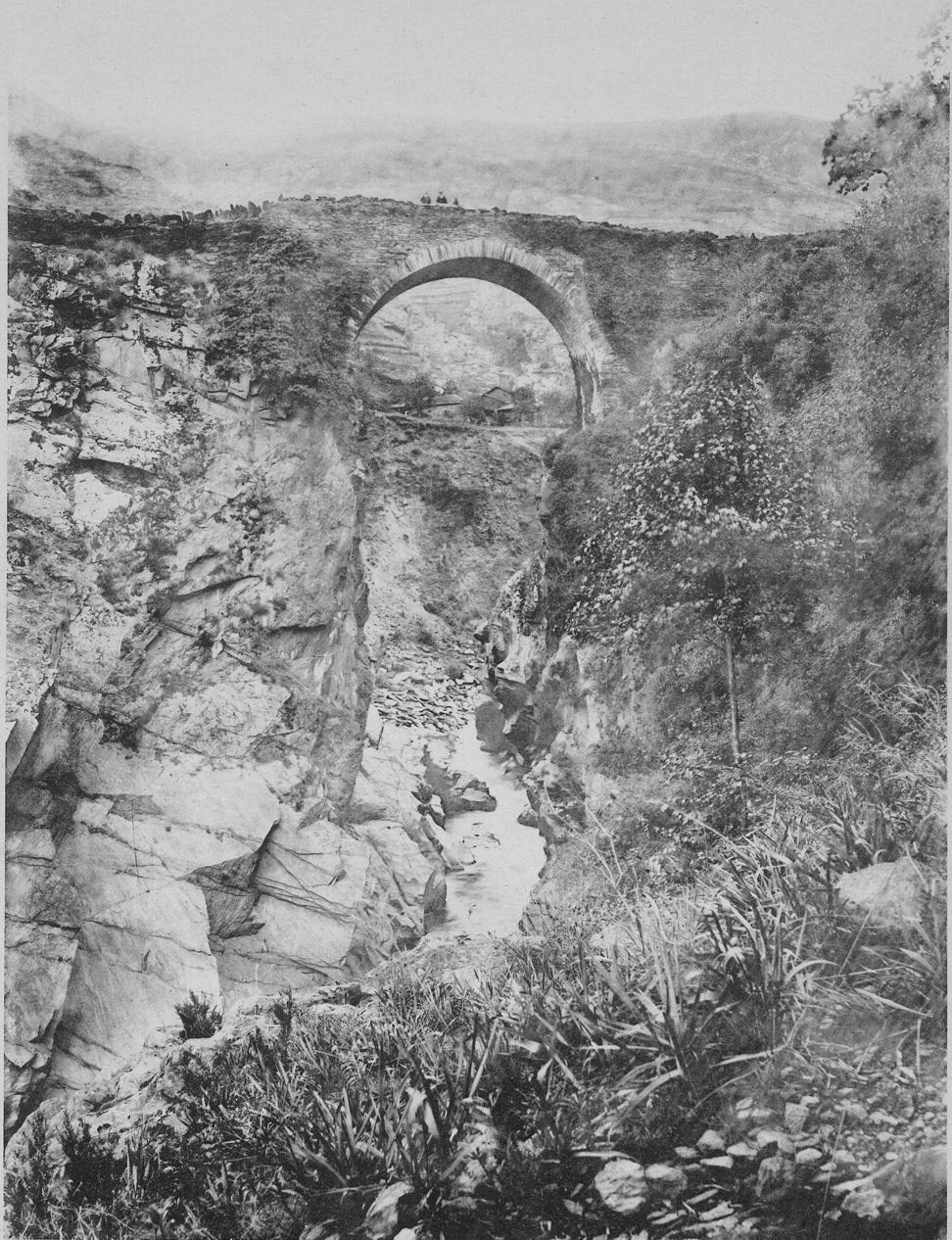
Ponte de Salime
Grandas de Salime
Ponte de Salime (Puente de Salime), a historic bridge over the Navia River in the municipality of Grandas de Salime in western Asturias, no longer exists in its old form – it now lies at the bottom of the Embalse de Salime reservoir, flooded in 1953. For visitors, the site combines a striking piece of engineering history with the dramatic landscape of one of twentieth-century Spain's largest hydroelectric projects. What is left to see at the site today? The original bridge dates back to 1548, built during the reign of Philip II: a single stone arch spanning 16 metres, suspended nearly 50 metres above the riverbed. For more than three centuries it was the only crossing over the Navia along the final seventy kilometres of its course, a vital link between Asturias and Galicia. In October 1936 the bridge collapsed after a landslide, killing two people who were crossing it at the time. It was rebuilt in 1938 in an entirely different technique: four articulated reinforced-concrete semi-arches, each weighing around six tonnes, joined with lead hinges, spanning 20 metres between abutments with a 3.6-metre width and a 2.5-metre roadway. The work was overseen by engineer José María González del Valle, third Marquis of Vega de Anzo, at a cost of 11,000 pesetas. That rebuilt bridge lasted barely fifteen years – by 1953 it had vanished beneath the rising waters of the reservoir. What travellers see today instead is the dam and the Embalse de Salime reservoir itself, built between 1946 and 1954. On completion it was the largest reservoir in Asturias and, at the time, the largest in Spain and in Europe. Flooding the valley ended more than a dozen settlements, including Salime itself – the municipal capital until 1836 – along with Subsalime, San Feliz, Albeira, Salcedo, Doade, Veiga Grande, Saborín, A Quintá, Ríodeporto, Vilagudín, A Barqueiría, San Pedro de Ernes and Barcela. The dam and its power station are adorned with artwork by architects Joaquín Vaquero Palacios and his son Joaquín Vaquero Turcios, whose reliefs and large mural inside the turbine hall rank among the finest examples of industrial heritage in Spain. How do you get to Grandas de Salime? Grandas de Salime sits deep in western Asturias, close to the Galician border, along the Camino Primitivo, one of the historic paths of the Camino de Santiago. Driving is by far the easiest option: from Oviedo the journey takes roughly two hours along winding mountain roads through the Navia River valleys. The nearest larger towns are Ribadeo and Fonsagrada on the Galician side, and Pola de Allande on the Asturian side. There is no direct rail access, so a private car or a local bus from Oviedo is essentially the only way in. When should you visit? Late spring and early autumn are the best times to visit, when temperatures suit walking along the reservoir's shoreline and water levels reveal the distinctive contours of the flooded valley. Summer brings heat and crowds of pilgrims walking the Camino Primitivo, while winter often makes the mountain access roads difficult because of rain and fog. Frequently Asked Questions Can you still see the Ponte de Salime bridge today? No – both the original bridge and its twentieth-century reconstruction disappeared under the reservoir's waters in 1953. What stands at the site today is the Embalse de Salime dam and reservoir, built over the old riverbed the bridge once crossed. Why was the bridge historically important? For more than 300 years it was the only crossing over the Navia River along a seventy-kilometre stretch, linking Asturias with Galicia and enabling trade and pilgrim traffic through this remote mountainous region. What else is worth seeing around the reservoir? Besides the dam itself and its viewpoints over the reservoir, it's worth seeing inside the hydroelectric power station, decorated with reliefs and murals by architects Joaquín Vaquero Palacios and his son Joaquín Vaquero Turcios, ranked among the finest examples of industrial heritage in Spain. Are there hiking trails nearby? Yes – the Camino Primitivo passes through the area, and local paths follow the shoreline of the Embalse de Salime, offering views over the mountains and the submerged valley of the Navia River.
-
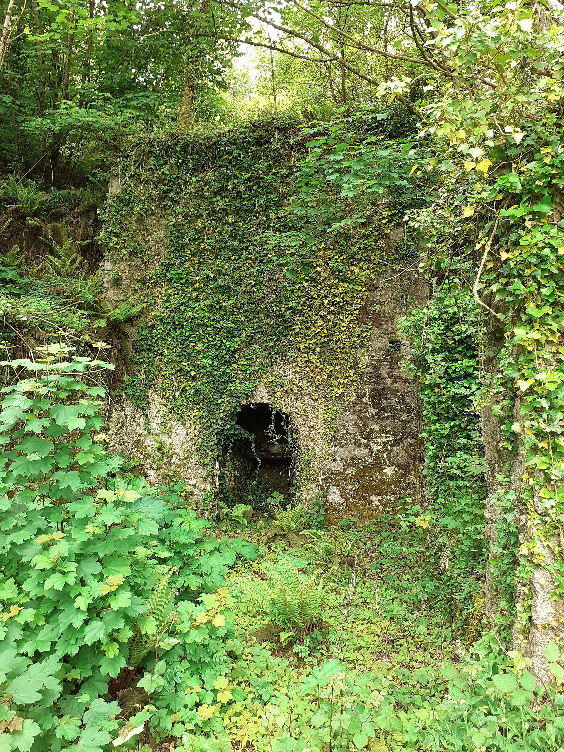
Forno de Cal da Muíña
Baleira
Forno de Cal da Muíña Forno de Cal da Muíña is an old lime kiln standing in the village of Muíña, in the municipality of Baleira, in the province of Lugo, Galicia. It is the kind of site that is easy to miss from the main road, yet the stone structure tells a genuine story about a rural industry that once kept local farms running. Where exactly is Muíña? Muíña is a small village split between two municipalities: one half falls under the parish of Retizós, in Baleira, while the other belongs to the parish of Milleirós, in the neighbouring municipality of Pol. Both lie in the northern part of Lugo province, an area crossed by a band of limestone deposits running roughly 100 metres wide from the north of the province southward. It was this limestone that made a quarry and a lime kiln possible here in the first place. Baleira itself belongs to the comarca of A Fonsagrada, with O Cádavo as its administrative seat. What will you actually see? The kiln takes the shape of a truncated cone, a form typical of traditional lime kilns in this part of Galicia. Comparable kilns recorded near Mondoñedo reached about 7 metres in height and 4 metres in internal diameter at the base, with walls roughly a metre thick. At the front sat an opening, the boqueira, flanked by walls that projected outward, and inside, about a metre above ground level, ran a working platform. In Muíña, the remains of the old industrial complex — quarry and kiln together — are still visible today, standing among the fields. Walking up to the kiln, look at the stone field walls and the roadside embankments nearby: limestone is visible in them at a glance, a clear reminder of why this particular patch of countryside once supported a lime-burning trade. How did the kiln actually work? Firing lime was slow, hot work that demanded constant attention. The kiln was loaded with blocks of limestone, then the upper opening was sealed, leaving only the lower entrance clear. Workers lit the fire with gorse and kept it burning without interruption, in a typical cycle lasting around 60 hours, with shifts rotating every four hours to maintain temperatures above 900°C inside the chamber. At the Muíña kiln, though, the main fuel was reportedly wood and mineral coal rather than gorse alone, and a single firing could consume as many as 50 cart-loads of fuel. The result was quicklime, put to two main uses in the surrounding countryside: mixed with water and sand into mortar for binding stone walls, and spread on fields as a soil fertiliser. For the farming communities of the Lugo hinterland, this was a working piece of infrastructure rather than a curiosity. How do you get there? Muíña sits deep in rural Galicia, within the municipality of Baleira, close to the boundary with Pol. A car is the practical way to reach it — local roads connect O Cádavo, the seat of Baleira, with the surrounding villages of the A Fonsagrada comarca. Expect classic inland Lugo scenery on the way: rolling hills, pasture, and dry stone walls, so it helps to set Muíña itself as the destination on a GPS rather than relying on signposts alone. When is the best time to visit? The kiln sits in the open countryside, accessible year-round, with no opening hours or admission fee to plan around. Spring and summer are the most pleasant seasons, when the weather in this hilly part of Lugo suits a longer walk and the fields around the stone structure are at their greenest. Autumn and winter can bring muddier paths, so sturdy footwear is worth packing. Frequently asked questions What is Forno de Cal da Muíña? It is a former lime kiln, built as a truncated cone, which together with a nearby quarry once formed a small local lime-production site. Where exactly is it located? In the village of Muíña, split between the parish of Retizós (Baleira) and the parish of Milleirós (Pol), in the province of Lugo, Galicia. What was the lime produced here used for? Mainly as mortar for binding stone in walls and buildings, and as a fertiliser spread on agricultural land. Is there an entrance fee? No — it is an open-air rural site, freely accessible at any time, with no tickets or fixed opening hours.
-
Torre de Cónchar
Villamena
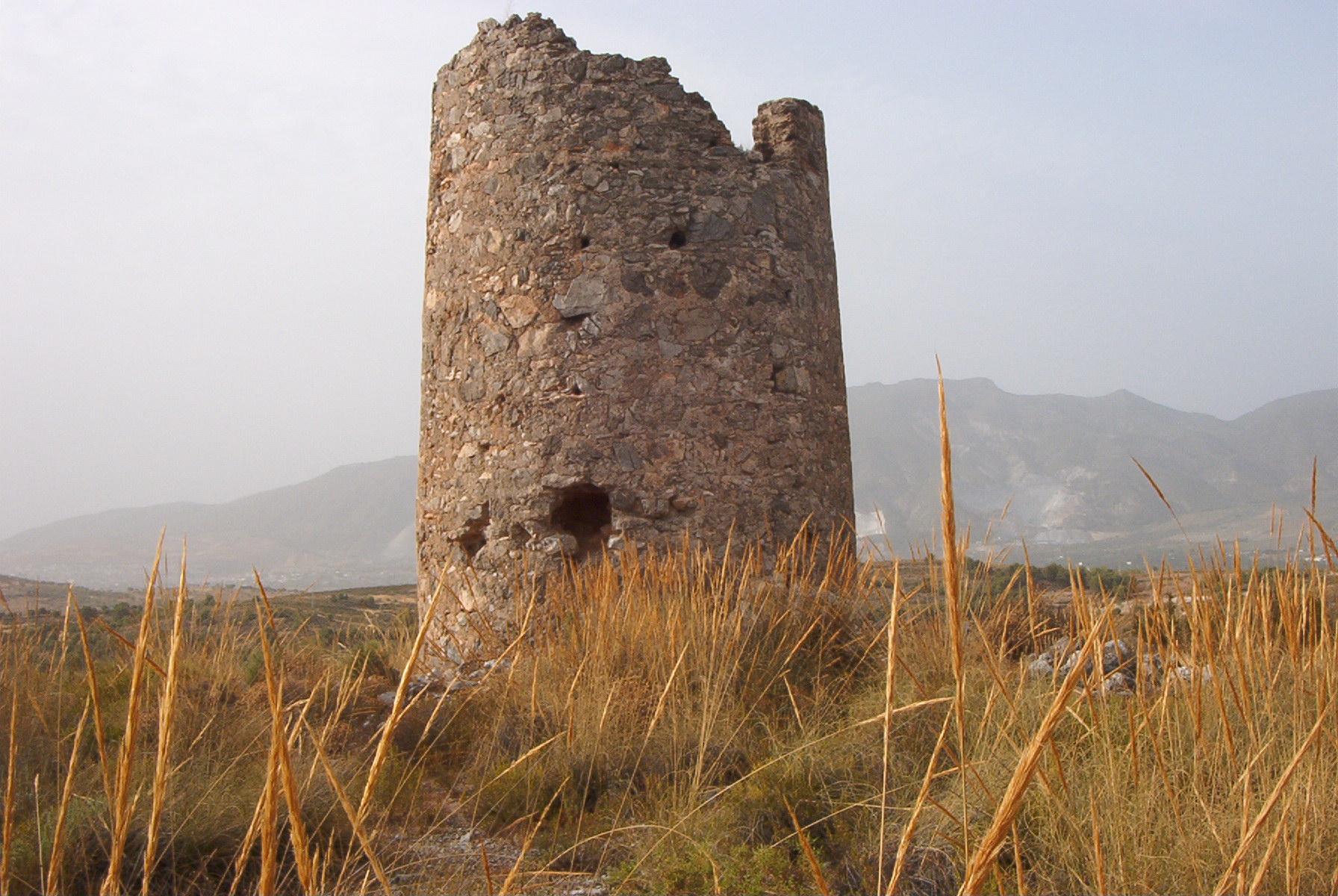
Torre de Cónchar is a medieval watchtower in the municipality of Villamena, set in the Valle de Lecrín in Granada province. Also known as Atalaya de Cónchar, it belonged to a network of signal towers raised during the Nasrid period, the last stretch of Muslim rule on the Iberian Peninsula. What kind of building is it? Unlike a castle, Torre de Cónchar was never meant to house a garrison. It is an atalaya, a lookout tower built to relay light or smoke signals between watch points scattered across the valley. The structure has a circular, truncated-cone plan and was built in masonry (mampostería). Its surviving height today is roughly 6.5 metres, and patches of the original exterior render are still visible on parts of the wall. Two brick-lined openings remain in the structure. The upper one may have worked as a door-window, giving the watchman access to the interior and a vantage point over the surroundings. The second is a loophole with a flared, funnel-like profile — a common defensive feature of the period, designed to let a lookout scan the terrain while limiting exposure to anyone approaching from outside. Where is it and how do you get there? The tower stands along the route linking the villages of Cónchar and Cozvíjar, both part of the Villamena municipality in the Valle de Lecrín. Its coordinates are approximately 36.978, -3.600. Because it sits outside the built-up centre of either village, a car is the most practical way in: the local road connecting the two settlements passes near the tower, and the final stretch is on foot. There is no regular public transport to the site, so it works best as a stop on a self-driven route through the Lecrín valley rather than a standalone destination. What will you see on site? Despite its modest size, the tower's clean conical silhouette and the surviving traces of render make an impression up close. Look closely at the two openings in the wall — it is easy to picture a watchman scanning the valley from there, waiting for a signal from a neighbouring post. That network of mutual visibility is really what gives the site its meaning: from Torre de Cónchar there is a clear line of sight to the Castillo de Dúrcal, to Torre de Marchena, and to the atalaya at Saleres. Together, these towers formed an early-warning system that covered the entire Valle de Lecrín. The surrounding landscape is classic Sierra Nevada foothill country — terraced slopes, orchards, and views over the neighbouring hills. It is a good spot to pause and take in the valley from roughly the same vantage point its medieval watchmen once had. When is the best time to visit? The tower stands in open country with no shade or shelter nearby, so spring and autumn bring the most comfortable conditions in this part of Andalusia. In summer, an early-morning visit is worth planning before the heat builds up. Winters in the valley tend to be cool but largely dry, which makes for good walking and photography conditions around the site. Frequently asked questions Is Torre de Cónchar a castle? No. It is an atalaya, a watch-and-signal tower built for surveillance and communication rather than permanent habitation or garrison defence. How old is the tower? Archaeologists date it broadly to the Nasrid period, the final centuries of Muslim rule in Andalusia before the conquest of Granada in 1492. Can you go inside the tower? The site is a protected piece of cultural heritage, so visits are generally limited to viewing the structure and its surviving openings from the outside. Which other towers did it communicate with visually? It kept sightlines to the Castillo de Dúrcal, to Torre de Marchena, and to the atalaya at Saleres, together covering the whole Valle de Lecrín.
-
Torre dels Moros (Riudecols)
Riudecols
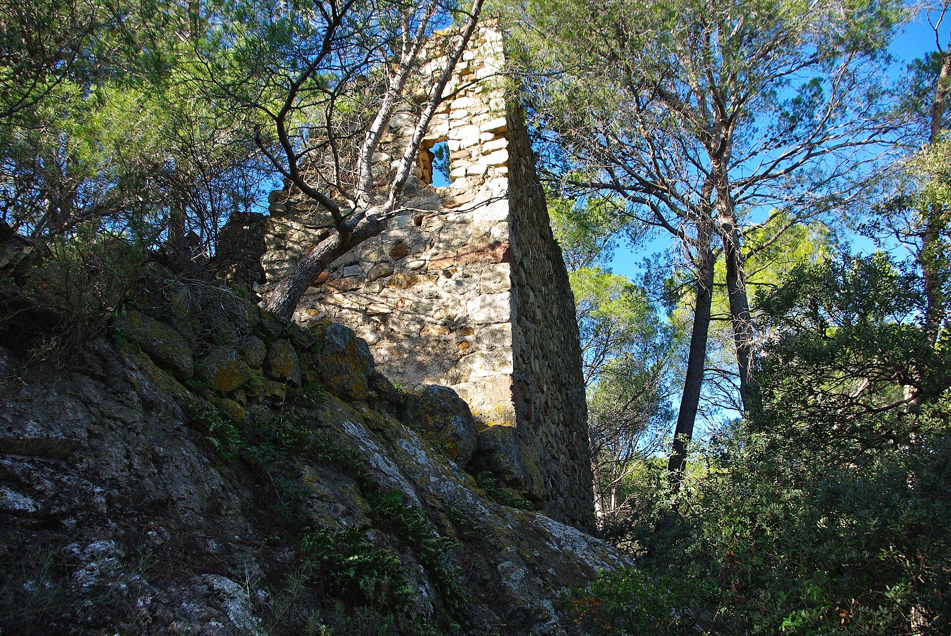
Torre dels Moros is a medieval watchtower near Riudecols, a small municipality in the Baix Camp region of Tarragona province. Standing in ruins on a hillside away from the village, this protected heritage site recalls the era when Catalonia's coast and inland routes needed constant watching against seaborne raiders. Where exactly is the tower? The tower sits along the Camí de les Roques path, between the Vilavella hill and the railway line, roughly three kilometres southeast of Riudecols. The surrounding landscape belongs to Baix Camp, the fertile strip between the Prades mountains and the Costa Daurada coastline, where olive groves and vineyards now share the ground with scattered remains of medieval defensive structures. Why is it called the "Tower of the Moors"? Despite its name, Torre dels Moros — literally "Tower of the Moors" — was not built by Muslim settlers. The name is common across Catalonia and was applied to watchtowers erected to spot threats arriving from the sea, including Barbary pirates who raided the Mediterranean coast well into the early modern period. The Riudecols tower most likely dates from the 16th century or earlier, and its job was to keep watch over the roads leading inland and warn nearby settlements of approaching danger. What survives on site today? What remains is a ruined structure with a trapezoidal floor plan, measuring roughly eight by five metres at the base and standing about five metres tall. It was built from rubble masonry with reinforced corners, a construction detail meant to add stability and resist assault. Traces of loopholes and sections of crenellation — the notched parapet typical of defensive towers — are still visible, even though the structure has partially collapsed over the centuries. What's left is enough to read the tower's original, strictly military purpose. Is there more history buried nearby? At the foot of the tower, archaeologists have identified the remains of a Roman villa along with a small late-Roman necropolis. This points to much older habitation on the site, long before the medieval watchtower was raised, layering Roman-era settlement beneath a later chapter of coastal defence. For visitors interested in the archaeology of Baix Camp, this combination of periods on a single hillside is a notable detail. Who should visit? Torre dels Moros suits hikers and history enthusiasts rather than travellers looking for a fully equipped attraction — there is no visitor infrastructure at the site. Reaching it means walking through farmland and local tracks, so it works best as part of a longer countryside walk around Riudecols, possibly combined with other Baix Camp heritage sites. The effort of the approach is rewarded with open views over the surrounding hills and valleys. Frequently Asked Questions What is Torre dels Moros in Riudecols? It is the ruin of a medieval watchtower, dating from the 16th century or earlier, built to monitor the coast and inland roads and warn of pirate raids. Why is it called the Tower of the Moors? The name is conventional and appears on many Catalan watchtowers; it refers to the tower's role in watching for raiders arriving by sea, not to a Muslim origin of the building itself. How do you get to the tower? It stands along the Camí de les Roques path, between the Vilavella hill and the railway line, about three kilometres southeast of Riudecols, reachable on foot via local farm tracks. Is there anything else to see around the tower? Yes — remains of a Roman villa and a small late-Roman necropolis lie at its base, evidence of settlement on the site long before the medieval tower was built.
-
Erillcastell
el Pont de Suert
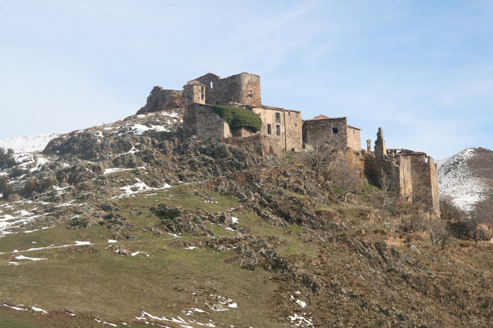
Erillcastell is an abandoned village and medieval castle ruin in the municipality of El Pont de Suert, in the Alta Ribagorça county, Lleida province, Catalonia. Perched at 1,441 metres above sea level near the Pic Redó summit, it has stood completely uninhabited for decades — one of the Pyrenees' many deserted mountain hamlets, visited today mainly for its history and its setting. Why does Erillcastell matter historically? Erillcastell was the original seat of the House of Erill, one of the leading noble lineages of medieval Ribagorça. The village first appears in written records in 1064, when Count Artal I of Pallars ceded it to his cousin Ramon IV. At its height, the barony of Erill — centred on the castle here — controlled a large stretch of the Pyrenees: the Vall de Boí, where the family sponsored construction of the Romanesque churches now inscribed on the UNESCO World Heritage list, along with the valleys of Viu, Manyanet and Vall Fosca, and the eastern bank of the Noguera Ribagorçana river between Pont de Suert and Espills. How did the lordship and the castle evolve? After a confiscation in 1506, the barony passed to Joan Ramon Folc de Cardona. The title was raised to a county (comtat d'Erill) in 1599, and in 1708 the pretender archduke to the Spanish crown attached the rank of Grandee of Spain to it. The castle itself gradually lost its defensive role: the original fortified structure was replaced by a more residential manor house built on the hilltop, while the church of Santa Maria d'Erillcastell was raised lower down the slope. Why was the village abandoned? For centuries Erillcastell lived off the farming and livestock economy typical of high Pyrenean villages, and for a time it also had a coal mine — likely tapping the same seam as the mines at nearby Malpàs — which kept some industrial activity going into the mid-20th century. Even so, the same rural depopulation that emptied much of the Pyrenees eventually caught up with it: a 1970 census counted just 9 remaining residents. Today no one lives here. What is left to see on site? Visitors find the ruins of the old settlement, remains of the former manor house of the Erill lineage, and the church of Santa Maria d'Erillcastell, whose fabric has visibly deteriorated — documented decline is evident between the 1960s and the 2010s. Some of the still partly roofed structures are now used by local farmers to shelter livestock. The castle-and-village site is listed as a Cultural Asset of National Interest (BCIN) on Catalonia's heritage register. How do you get to Erillcastell? Access is via a mountain track, and the final stretch requires a 4x4 vehicle. Exploring the ruins calls for caution: parts of the walls, particularly around the church, are at risk of falling stones, so it's worth keeping a safe distance from the most damaged sections. Erillcastell suits travellers interested in medieval Ribagorçan history and Pyrenean cultural landscape rather than visitors looking for a fully developed tourist site. Frequently Asked Questions Is Erillcastell still inhabited? No. The village has been completely deserted since the second half of the 20th century; a 1970 census recorded only 9 inhabitants. Who were the lords of Erill? A medieval noble family whose original seat was the castle at Erillcastell. Their barony was later raised to a county and, at its peak, extended influence over the Vall de Boí and neighbouring Pyrenean valleys. Can the ruins be visited safely? The site is accessible, but caution is required — the structures, especially the church of Santa Maria, are in poor condition, with a risk of falling stones. How do you reach the site? Erillcastell lies within the municipality of El Pont de Suert; the last part of the approach follows a mountain track that requires a 4x4 vehicle.
-
Dar Al-Arusa Palace
Grenada
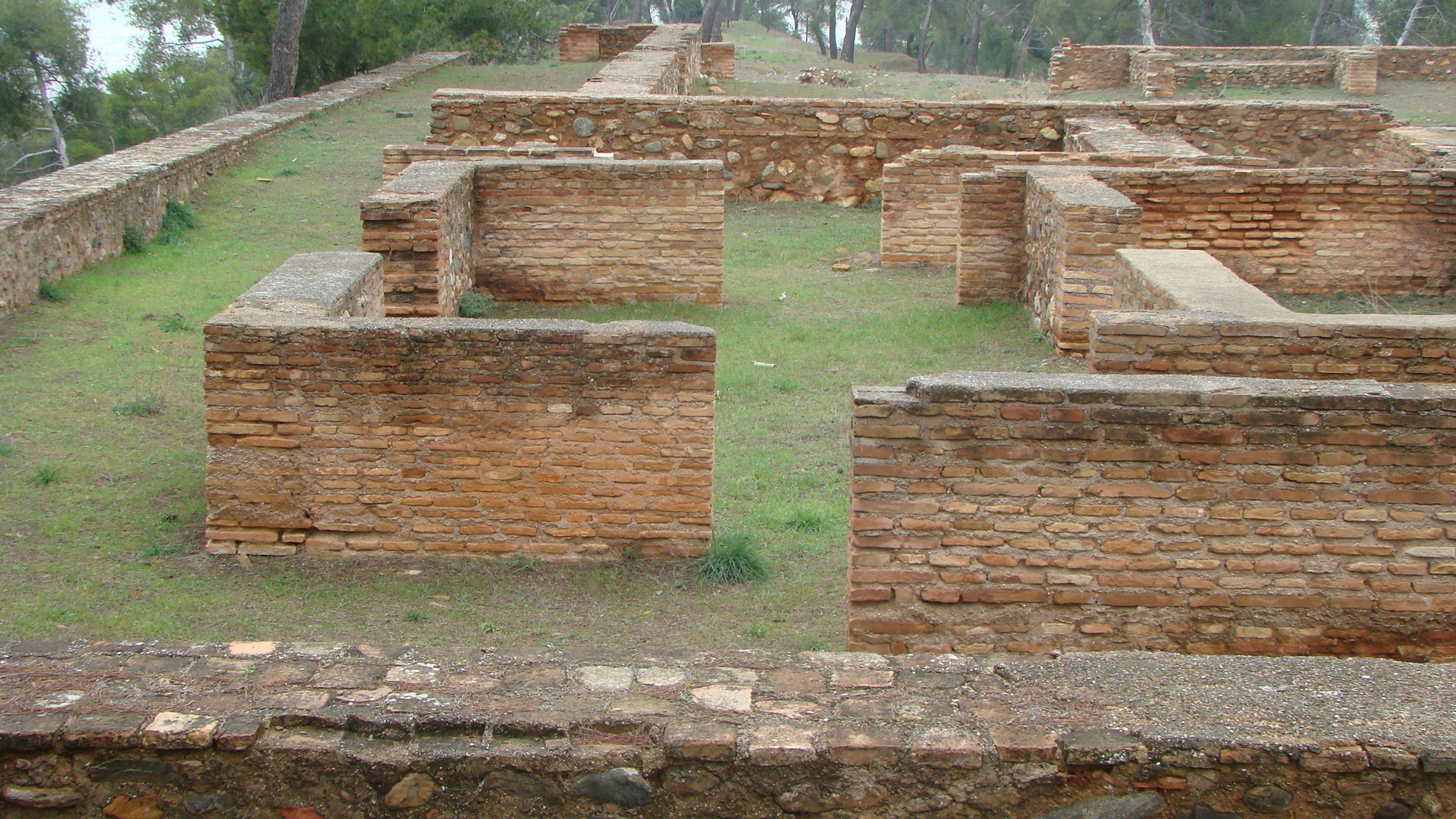
Dar Al-Arusa Palace stands in ruins on the Cerro del Sol hill above the Generalife in Granada. It is the highest residence ever built by the rulers of Nasrid Granada, tucked away among pines and scrubland above the Generalife gardens, and today it can only be visited during occasional guided walks organized by the Patronato de la Alhambra y Generalife. Why is it called the "Bride's Palace"? Dar al-Arusa literally means "house of the bride" in Arabic. The palace was built in the 14th century under Sultan Muhammad V, one of the most important builders of Nasrid Granada, who was also responsible for expanding the Alhambra's famous Palace of the Lions. Dar al-Arusa served as an almunia — a royal pleasure estate surrounded by gardens, set apart from the bustle of the court, where the sultan could retreat among water features, greenery and sweeping views over the Darro valley. Why was it called the "crown of the kingdom"? The palace was built at the very top of the Cerro del Sol, roughly 900 metres above sea level — higher than any other Nasrid-era building around Granada. Because it towered over the Generalife, the Alijares and the Silla del Moro, contemporaries referred to it as "the crown of the kingdom." From this vantage point the view stretched across the entire Alhambra complex, the Albaicín and the Sierra Nevada beyond — a location chosen deliberately to project the dynasty's power and prestige. What survives of the original residence? The complex was arranged around three courtyards. The largest contained a pool measuring seven metres long, ringed by living quarters laid out in the manner typical of Nasrid homes. In the northwestern corner, archaeologists uncovered the remains of a hydraulic system — a waterwheel used to draw water from a well — evidence of the advanced engineering needed to keep the palace supplied with water despite its high, dry setting. A near-complete bathhouse also survives, its double-bent passageway leading into a square room with a circular marble fountain, considered the most valuable decorative find on the site. How was the palace rediscovered? After the conquest of Granada in 1492, the residence gradually fell into obscurity. Chronicler Francisco Henríquez de Jorquera recorded it as abandoned as early as 1632, and over the following centuries the site was buried under soil and vegetation, all but vanishing from memory. It was rediscovered by chance in 1933, during pine-planting work on the slopes of the Cerro del Sol. Excavations led by architect Leopoldo Torres Balbás took three years and revealed the layout that can still be traced today. How do you visit Dar Al-Arusa? The ruins sit above the Generalife gardens, along the path that continues on to the Silla del Moro, reached on foot via the trails crossing the Cerro del Sol hill. Because the site is normally closed and can only be unlocked by a guard from the Patronato de la Alhambra y Generalife, visits are mainly possible through free guided walks that are organized occasionally, including during European Archaeology Days. It's worth checking the Patronato's current events calendar before a trip to Granada and combining the walk with a visit to the Alhambra and Generalife themselves. Frequently Asked Questions Can you visit Dar Al-Arusa on your own? No — the site is closed to independent visitors and can only be accessed during occasional guided walks organized by the Patronato de la Alhambra y Generalife. How is Dar Al-Arusa different from the Generalife? The Generalife is a well-known, fully restored garden palace open to visitors daily, while Dar Al-Arusa is a far lesser-known, partially preserved ruin set higher on the hill, well off the standard tourist route. When was the palace built, and by whom? It was built in the 14th century under Sultan Muhammad V, the Nasrid ruler of Granada also known for expanding the Alhambra's Palace of the Lions. What can you actually see on site? The main courtyard with its pool, the remains of a hydraulic waterwheel system, and a preserved bathhouse with a marble fountain — the most valuable decorative feature of the whole complex.
-
Puente del Cadí
Grenada
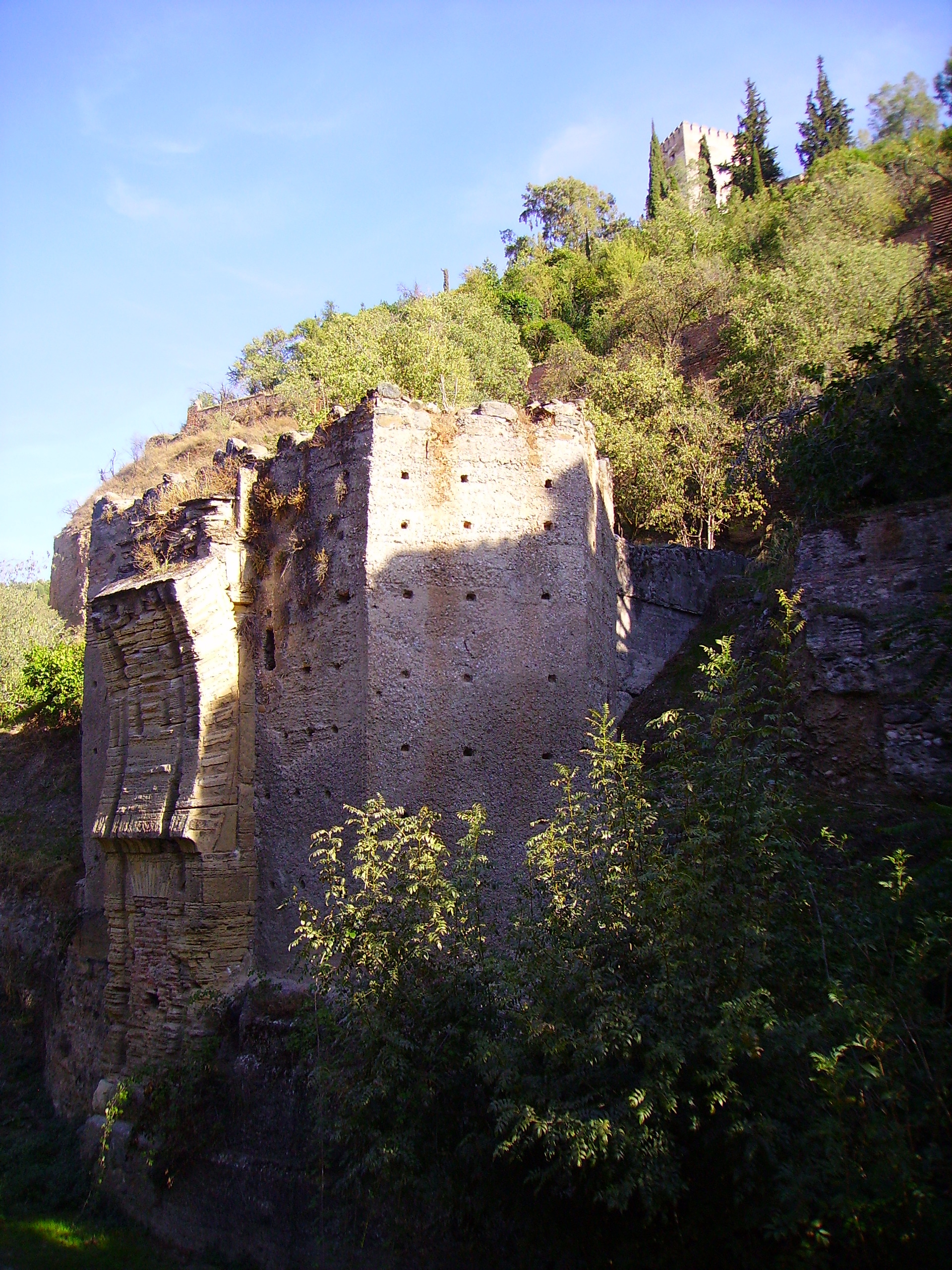
Puente del Cadí in Granada is a modest but telling fragment of a medieval bridge that once linked two of the city's most iconic quarters — the Albaicín and the hill of the Alhambra. Little survives of the original structure today, yet the site still draws travelers curious about Granada's Muslim-era past, long before the Catholic Monarchs arrived. Where exactly is Puente del Cadí? The remains stand beside the Darro river, at the foot of the Alhambra hill, right along Carrera del Darro — one of the most walked streets in Granada's historic core. The surviving structure sits on the left bank of the river, next to the Bosque de la Alhambra (the Alhambra Forest), which puts it directly on the natural walking route between the Albaicín and the entrance to the Alhambra grounds. Why is it called the "Cadí" bridge? The name refers to a cadí — a Muslim judge from the era of Zirid rule in Granada — on whose initiative the bridge was built back in the 11th century. For centuries it served as one of the key river crossings tying the Albaicín to the Alhambra, and it also functioned as a city gate known as the Puerta de los Tableros. The bridge is mentioned repeatedly in historical accounts describing the layout of Muslim Granada, a sign of how important it once was for getting around the city. The structure outlived the golden age of Nasrid Granada and the Christian conquest that followed it: in 1501 the Catholic Monarchs even ordered the bridge to be paved, proof it was still in active use at the time. It was finally demolished in the first half of the 17th century, and only a fraction of the original construction has come down to us. What remains to see today? Of the two original abutments, only one still stands — the one on the side facing the Alhambra Forest. It takes the shape of a hexagonal tower, and the start of a large horseshoe-shaped vaulted arch, typical of Andalusi architecture from that period, is still visible within it. The voussoirs forming the arch alternate in rhythm between recessed and projecting blocks, and traces of the original polychrome painting are still discernible. Concave cornice mouldings and an alfiz frame — a hallmark of Islamic art in Al-Andalus — complete the surviving decoration. Look closely at the sandstone ashlar blocks and you can spot grooves left behind: some from the wooden scaffolding used during construction, others from a metal grate that once sealed off river access at the bridge. In 1931 the remains were declared a historic-artistic monument, a designation that today translates into legal protection as a listed heritage asset in the Monument category. How to fit it into a Granada visit? Because the ruins sit right on Carrera del Darro, the easiest way to see them is simply to fold them into a walk from the cathedral and city center toward the Albaicín, continuing on up to the Alhambra hill. This is the route most visitors to Granada already follow on foot, so the bridge can be taken in along the way rather than as a separate excursion. Frequently Asked Questions Is there more left of the bridge than a single pillar? No — of the two original abutments, only one survives, shaped like a hexagonal tower, together with the springing of its vaulted arch. The rest of the structure was torn down in the 17th century. Where does the name "Puente del Cadí" come from? It refers to a cadí, a Muslim judge from the Zirid period, on whose initiative the bridge was built in the 11th century. Is there an entrance fee to see the ruins? The remains sit in a public space along the open Carrera del Darro, so viewing them from the street doesn't require a ticket. Is it worth a dedicated visit, or just a stop along the way? Given how small the surviving remains are, it's best treated as a stop on the walk connecting central Granada, the Albaicín, and the Alhambra, rather than a destination in its own right.
-
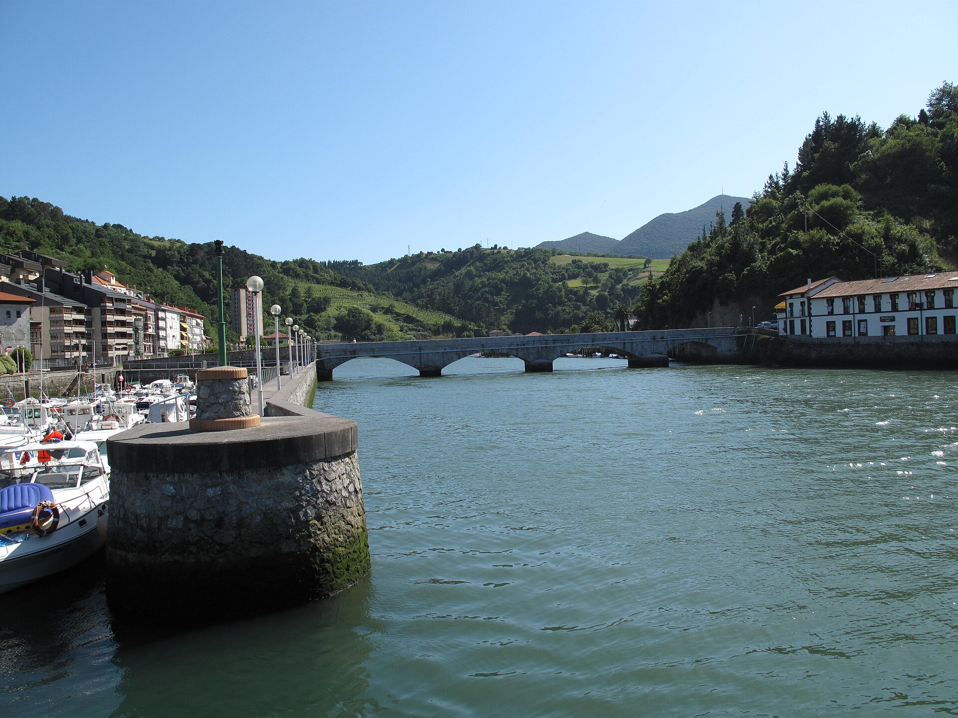
Deba-Mutriku zubia
Mutriku
The Deba-Mutriku bridge (Deba-Mutriku zubia) links the two coastal towns of Deba and Mutriku in Gipuzkoa, in the Basque Country. Spanning the mouth of the Deba River as it meets the Bay of Biscay, it has shaped this stretch of Basque coastline for more than a century and a half. Where exactly is the bridge? The bridge stands next to Deba's marina, close to the Agirre palace, joining the two riverbanks right where the Deba River empties into the sea. This spot has long been the natural crossing point between the coastal towns of Gipuzkoa. What is the history behind it? The bridge opened in 1866, completing the last stretch of the 19th-century coastal road connecting San Sebastián and Bilbao — a project that reshaped travel between the fishing towns of Gipuzkoa and Biscay. It originally had three stone arches plus a movable stone section that could be opened to let boats sail upriver into Deba's port; that movable part was dismantled in 1951 once river traffic upstream had dwindled. When the new Sasiola bridge opened in 2006 to carry road traffic, the old Deba-Mutriku bridge was closed to vehicles and became a footbridge. In the early hours of 4-5 July 2018, one of its central piers suddenly settled, damaging the two central vaults: stones shifted and cracked, and the structure twisted out of shape. The bridge was closed for repairs and later reopened, once again linking the two towns. What does the bridge look like? It's a substantial stone masonry structure faced in grey limestone, roughly 106 metres long, with a main span of about 50 metres on the Deba side. The roadway is just under 6 metres wide (5.95 m), flanked by narrow 0.4-metre stone footpaths on each side. Sturdy piers and buttresses support its arched form, typical of the solid 19th-century engineering found across this part of the Basque coast. Why is it worth a visit? Beyond its role as a crossing, the bridge is a symbolic link between two fishing towns with a strong maritime identity. Walking across it gives views over the Deba estuary, the marina, and a coastline known for the flysch rock formations stretching between Zumaia, Deba and Mutriku — one of the most distinctive stretches of the Basque Coast. For visitors exploring both towns on foot, the bridge is the natural shortcut between Deba's old town and Mutriku, saving a longer inland detour. Frequently Asked Questions Can cars cross the Deba-Mutriku bridge? No. Since the Sasiola bridge opened in 2006, the Deba-Mutriku bridge carries pedestrian traffic only. When was the bridge built? It opened in 1866 as the final stretch of the 19th-century coastal road linking San Sebastián and Bilbao. Has the bridge ever been damaged? Yes. On the night of 4-5 July 2018, one of its central piers suddenly settled, damaging the middle section of the structure and requiring repair work. How long is the bridge? It measures around 106 metres in length and just under 6 metres in width, with narrow footpaths on either side.
-
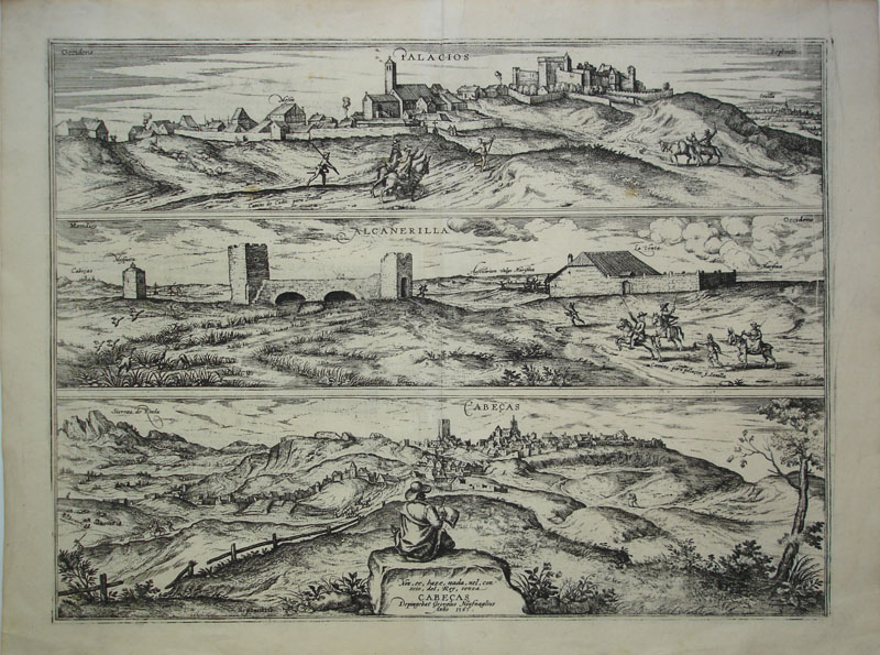
Puente Romano de las Alcantarillas
Utrera
Puente Romano de las Alcantarillas is a Roman bridge on the outskirts of Utrera, in the province of Seville, and one of the most recognizable surviving pieces of ancient road engineering in this part of Andalusia. It spans the former Salado stream next to the Castillo de Alcantarilla tower, and for centuries has served as a landmark for travelers heading southwest out of town. What is this bridge, and where does its name come from? The name "de las Alcantarillas" (also found as "de la Alcantarilla") derives from an Arabic word for bridge or culvert, itself a hint at how continuously this crossing was used across successive eras — Roman, Visigothic, Islamic, and Christian. The structure rests on two stone arches, though the bridge originally likely had two levels; the upper section has not survived to the present day. Why is it dated to Roman times? The bridge's dating to the reign of Augustus rests on an epigraphic inscription set between its two arches, with a surviving fragment read as "AUGUSTUS PONTEM...". This inscription is what allows historians to place the structure firmly within the context of Roman infrastructure policy in the early decades of the Common Era, a period when the road network across Hispania was being aggressively expanded. What role did it play in the Roman road network? The bridge formed part of the Via Augusta, the longest Roman road on the Iberian Peninsula, linking Cádiz with the Pyrenees and, beyond them, the rest of the empire. Specifically, it sat on the stretch between the former settlements of Orippo (today a depopulated site near the Guadalquivir and Guadaíra rivers, in the municipality of Dos Hermanas) and Ugia, which some researchers identify with the nearby Torre Alocaz. For travelers and merchants moving from southern Spain toward the interior, this crossing of the Salado was a critical point along the route. What can visitors see on site? The bridge forms an ensemble with the adjacent tower, the Castillo de Alcantarilla, which in later centuries took over guard duty for the crossing, controlling traffic along this stretch of road. Despite losing its upper level and bearing the marks of several restorations, the two-arch structure still clearly displays its Roman origins — the proportions of the arches and the stonework technique remain characteristic of engineering from that period. The silhouette of the bridge with the tower behind it has become one of the recognizable promotional images of Utrera. What does the surrounding area look like? It's worth knowing that the bridge's immediate surroundings were heavily reshaped by modern infrastructure over the 20th century: to the south run the Bajo Guadalquivir canal and the Seville–Cádiz railway line; to the west, the N-IV highway runs parallel to the old Roman road; and the Cañada Real de las Cabezas de San Juan — a historic cattle-droving route — together with the SE-427 road, passes directly over the bridge itself. This layering of an ancient structure with modern transport lines is a clear illustration of how the same natural corridor has been used for travel continuously since Roman times. Who is this destination for? Puente Romano de las Alcantarillas suits travelers interested in ancient history and traces of the Roman presence in Andalusia, as well as anyone planning a route through the historic sites of Seville province beyond the provincial capital itself. It pairs naturally with a visit to Utrera and the surrounding archaeological remains connected to the Via Augusta. Frequently Asked Questions What period does the bridge date from? The bridge is dated to the reign of Emperor Augustus, based on an inscription placed between its two arches. What was its function in antiquity? It formed part of the Via Augusta, the main Roman road linking Cádiz with the Pyrenees, on the stretch between Orippo and Ugia. Has the bridge survived in its original form? Partly — the two stone arches remain, but the bridge's upper level has not survived, and the structure has undergone several restorations over time. What else is located near the bridge? The Castillo de Alcantarilla tower stands beside it, which in later centuries guarded the crossing over the Salado river.
-
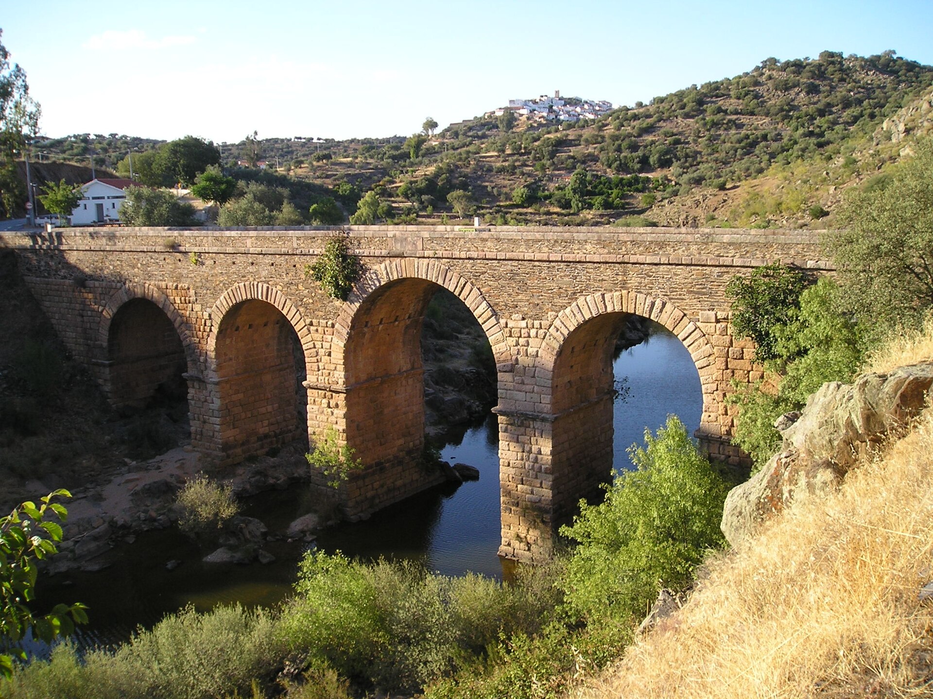
Ponte de Segura
Idanha-a-Nova
Ponte de Segura is a Roman bridge in Segura, a village in the municipality of Idanha-a-Nova, linking the Portuguese borderlands to the Spanish town of Alcántara. Spanning the Erges river, a tributary of the Tagus, it has served as a border crossing for centuries and stands as one of the most notable pieces of ancient engineering in the Beira Baixa region. What kind of bridge is this? Ponte de Segura is a five-arch stone bridge originally built by the Romans to cross the Erges. The river forms the natural border between Portugal and Spain, so the bridge has always joined two countries: Segura on the Portuguese side, Alcántara on the Spanish side. Today it stands as evidence of continuous settlement and trade along this stretch of the border, reaching back to Roman times. How much of the bridge is actually Roman? Of the five arches, only two — the ones closest to each riverbank — belong to the original Roman construction. The other three were rebuilt or added much later, during works carried out in the 16th and 19th centuries, as the structure aged or needed reinforcement. Despite this patchwork history, the bridge reads as a single, coherent structure, a result of the careful craftsmanship applied during its various repairs. Why does the 1571 reconstruction matter? A key moment in the bridge's history was the 1571 reconstruction of two of its arches. The stonemasonry carried out at that time is so precise that it is now considered barely distinguishable from the original Roman work. That level of craftsmanship is why Ponte de Segura, despite centuries of repairs, still feels like a single ancient monument rather than a mix of mismatched eras. Where exactly is the bridge located? Ponte de Segura stands in the village of Segura, part of the municipality of Idanha-a-Nova, in Portugal's Beira Baixa region, right on the border with Spain. Its coordinates are approximately 39.817° N, 6.982° W. The bridge crosses the Erges precisely where the river marks the international boundary, with the Spanish municipality of Alcántara — itself famous for its own monumental Roman bridge over the Tagus — on the other side. Why is it worth visiting? Ponte de Segura appeals to anyone interested in Roman history, bridge architecture, or the quiet border landscape of the Erges valley. It's a place where you can see, in person, how a single crossing has functioned for roughly two thousand years — repaired and reinforced many times, yet never replaced by a new structure. For travelers exploring the Portugal-Spain border region, it makes a natural stop on a route linking Idanha-a-Nova with Spanish Extremadura, including nearby Alcántara. Frequently Asked Questions What is Ponte de Segura? It is a Roman bridge over the Erges river, connecting the Portuguese village of Segura (municipality of Idanha-a-Nova) with the Spanish town of Alcántara. How many arches does the bridge have, and which ones are original? It has five arches. Only two, the ones nearest each riverbank, date from Roman times — the rest were added during 16th- and 19th-century reconstructions. What is notable about the 1571 reconstruction? The stonework done on two arches during that rebuild is considered barely distinguishable from the original Roman masonry, reflecting the high quality of the craftsmanship involved. Which river does the bridge cross, and where does it lead? It crosses the Erges river, a tributary of the Tagus, linking Segura in Portugal to Alcántara on the Spanish side of the border.
Earn badges for the places you visit
Download NextOnTrip, discover new places and check off your trails.