Monuments in Spain
A guide to 4655 Monuments in Spain — with descriptions, photos and traveler visits from the NextOnTrip community. Locations spread across 2240 cities and towns. Most visited by the community: castle of Chulilla, Castle of Pioz, castell de la Todolella.
-
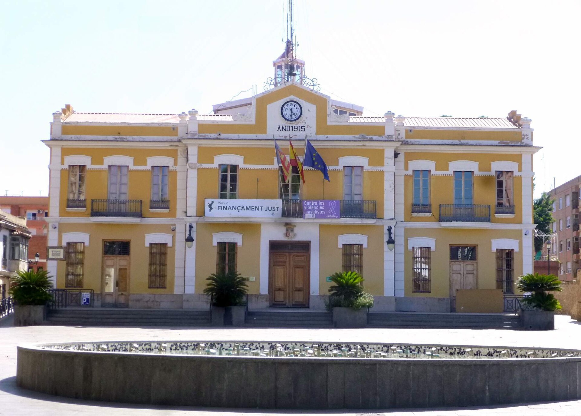
Burjassot town hall
Burjassot
Burjassot Town Hall (Ayuntamiento de Burjassot) is the seat of local government in this town in the province of Valencia, just a few kilometers northwest of Valencia's city center. Standing on the town's main square, the building has anchored local life for over a century and makes a natural starting point before heading toward Burjassot's best-known attraction, the underground grain silos of Cuevas del Trigo. Where exactly is the town hall located? The building sits on Burjassot's main square, the administrative and social hub of the town. Local celebrations, markets, and community gatherings regularly take place here, and the square itself is a convenient jumping-off point for exploring the old part of town. At coordinates 39.5086, -0.4114, the town hall sits right in the heart of the historic center, within easy walking distance of Burjassot's main sights. What does the building look like? The current town hall dates from 1915, reflecting the early-20th-century civic architecture common across many Spanish towns of that era, when municipal buildings were modernized while keeping a formal, representative facade. The building stands out from the surrounding streetscape, and the square in front of it is well kept and landscaped, making it a pleasant spot to pause during a walk through town. Why combine a visit here with the rest of Burjassot? The town hall itself is a landmark rather than a destination in its own right — the real draw nearby is Cuevas del Trigo, a network of underground grain silos carved into the rock and used since medieval times to store wheat. It's a distinctive piece of historic infrastructure rarely found elsewhere in the region, and walking from the town hall square toward the silos takes visitors through an older, quieter side of Burjassot. Because the town sits so close to Valencia, it's easy to fold a stop here into a longer day exploring the regional capital. Is the town hall worth seeing if you're not into architecture? Yes — the appeal isn't really about touring the interior, but about the square itself: it functions as the town's everyday gathering point and a good launch pad for further exploring, whether you're drawn to the building's history or simply curious about daily life in a smaller town on Valencia's doorstep. Frequently Asked Questions Where exactly is Burjassot Town Hall located? It stands on the main square in the center of Burjassot, in the province of Valencia, just outside the city of Valencia itself. When was the current town hall building built? The present building dates from 1915, in a style typical of early-20th-century civic architecture. Are there other attractions near the town hall worth visiting? Yes, the Cuevas del Trigo underground grain silos — one of Burjassot's most distinctive attractions — are located a short walk away. Can visitors go inside the town hall? The building functions as an active municipal office, so interior access may be limited to administrative business during office hours — it's worth checking locally before visiting.
-
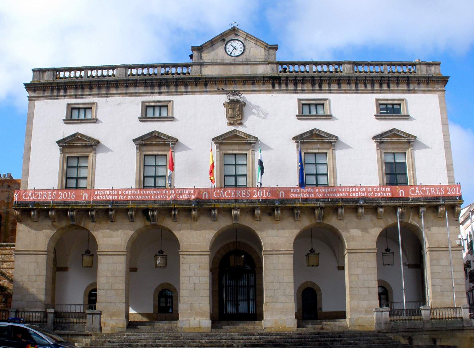
Cáceres town hall
Cáceres
Cáceres town hall is the seat of the municipal government, standing on Plaza Mayor in Cáceres, in Spain's western region of Extremadura, right at the entrance to the UNESCO-listed old town. Where is the town hall and why start a visit here The town hall closes off one side of Plaza Mayor facing the old town, making it a natural launch point before heading up to the walls. The current building dates from 1869 and was designed by architect Ignacio María de Michelena, which means it is considerably younger than the stone quarter behind it — cross the square and pass through the walls, and the medieval city on the other side has survived in largely unchanged form. Plaza Mayor has served as the gateway into the old town for more than five centuries and remains the city's main gathering point today, hosting markets, festivals and everyday social life. Cafés and outdoor terraces line the square, giving a clear view of the town hall's façade and of the walls and towers rising directly behind it. What to see around the town hall Behind the town hall, on the far side of the walls, begins the Old Town of Cáceres, recognised as a Monumental City by the Council of Europe in 1968 and added to the UNESCO World Heritage list in 1986. The fortifications enclosing the old town run for roughly 1,174 metres and protect an area of about 9 hectares, densely packed with stone palaces, towers and churches. At the southern end of Plaza Mayor, right beside the town hall, sits the Foro de los Balbos — a viewpoint and archaeological site that opens onto the walls and one of the towers overlooking the square. It is a good spot for a photo that combines the square's newer architecture with the ancient line of fortifications. How to plan a visit to the old town from the town hall The simplest approach is to start at Plaza Mayor, walk past the town hall building, and enter the old town through one of the historic gates in the walls. Streets inside the fortifications are narrow and winding, and most are closed to car traffic, which makes for an unhurried walk. Set aside at least two to three hours for the old town alone if the plan includes stepping into any of the churches or palaces along the way. Because the ground around the town hall and inside the walls is uneven cobblestone with frequent slopes, the area can be demanding for visitors with limited mobility — worth factoring into the route. Frequently Asked Questions What's the difference between the town hall and the old town of Cáceres? The town hall is a 19th-century administrative building standing on Plaza Mayor, outside the walls. The old town is a much older, walled quarter behind the square, added to the UNESCO list in 1986. Is Plaza Mayor the right place to start a visit? Yes — the square has functioned as the main gateway to the old town for more than 500 years, so it is a logical starting point that shows both the newer square and the defensive walls. Is there anything else to see near the town hall besides the building itself? Yes, the Foro de los Balbos sits right beside the town hall, offering views of the walls and towers, with entrances into the old town leading from there. Is the old town of Cáceres easy to walk around? The streets are narrow, cobbled and sometimes uneven, but mostly closed to cars, which makes them safe and comfortable for an unhurried walk.
-
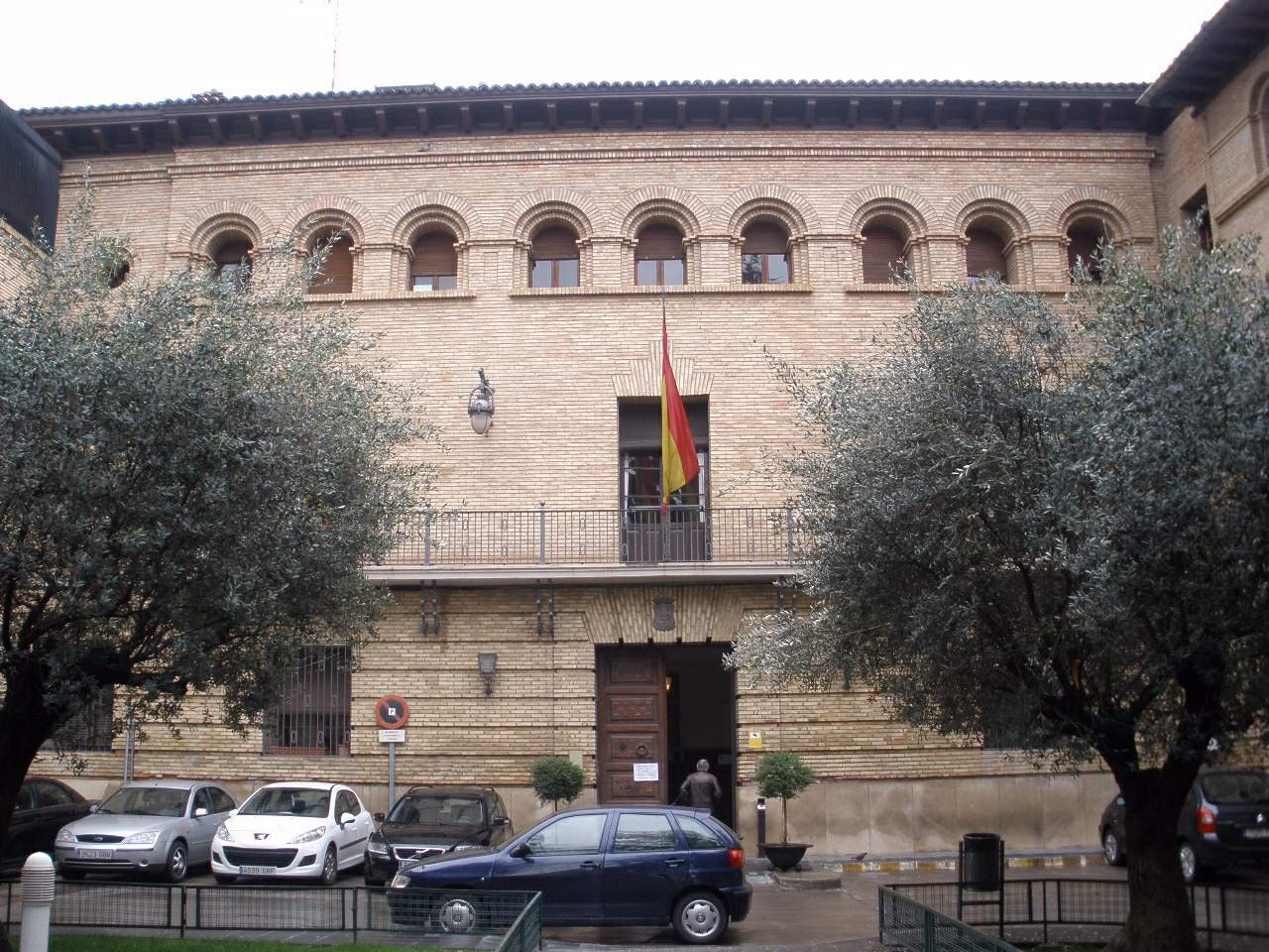
Barbastro City Council
Barbastro City Council (Ayuntamiento de Barbastro) is the seat of local government for Barbastro, a city in the province of Huesca, in the Aragon region of northeastern Spain. Where is the town hall located? The building sits on the main square of Barbastro's historic quarter, close to the Vero river. Barbastro serves as the leading town of Somontano, a wine-producing area at the foot of the Pyrenees known for its protected-designation wines. What is the history behind the building? The original town hall structure dates back to 1510. Local tradition credits its construction to Farag de Galí, a Moorish master builder active in the region around that period, at a time when towns across Aragon commonly blended Gothic and Mudéjar architectural influences. For centuries the building has served as the administrative heart of the municipality and a visible symbol of Barbastro's self-government. What else stands near the town hall? Just steps away, within the old town, rises a 16th-century cathedral recognized as a site of historic-artistic heritage. Surrounding it is an archaeological garden displaying finds spanning the 12th to 18th centuries. Nearby also stand the Episcopal Palace, the Diocesan Museum, and the house once belonging to the Argensola family, remembered as one of the notable literary names of the Spanish Renaissance. Why does Barbastro matter within Aragon? As the leading town of Somontano, Barbastro sits at a crossroads of winemaking tradition and religious architecture developed beneath the Pyrenees. The town hall itself, more modest than the nearby cathedral, remains a key landmark of the city centre and a venue for civic ceremonies and local events. Frequently Asked Questions Can visitors go inside Barbastro's town hall? Since the building serves an active administrative role, public access is generally limited to representative areas or occasional open events. Checking with the local tourist office before a visit is recommended. Where does the name Somontano come from? Somontano literally means "beneath the mountain," referring to the region's position at the base of the Pyrenees. Barbastro functions as its administrative and economic capital. How can travelers reach Barbastro? The city lies in Huesca province, connected by national roads linking Aragon with Catalonia. The nearest major airports are in Zaragoza and Huesca. What other sights are worth seeing beyond the town hall? Besides the cathedral and episcopal palace, visitors can explore the church and fountain of San Francisco and the San Julián complex, both testifying to the city's long history.
-
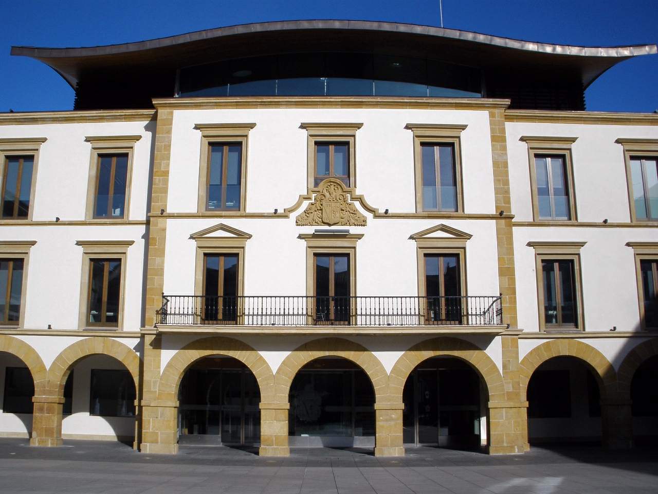
Amorebieta-Etxanoko Udala
Amorebieta-Etxano
Amorebieta-Etxano is a town in the province of Biscay, in Spain's Basque Country, regarded as the main town of the Durangaldea district. It sits on the banks of the Ibaizabal river, framed by the hills of Bizkargi and Urrimendi, and is home to close to 20,000 residents. Why does the town have a double name? The current municipality was formed in 1951 through the merger of two previously separate anteiglesias — the traditional Basque local government units — called Amorebieta and Etxano. That administrative union is the reason for the compound name still used today. The town hall sits on Herriko Enparantza square, right in the urban core. What can visitors see in the town centre? The historic core is anchored by the church of Santa María de la Asunción, best known for its main altarpiece, considered one of the more notable pieces of religious art in the district. Nearby stand several bourgeois residences dating from the turn of the 20th century: the four-storey neoclassical Palacio de Cancelada and Casa Harrison, an English-style mansion built in 1910. From the same period comes Casa de Canuto Basterra, built in a neo-Basque architectural style. Is there anything worth seeing outside the centre? Yes. The Bernagoitia neighbourhood has kept a more rural, distinct character, with the church of San Miguel standing alongside the Berna tower, which still holds medieval remains. Together they show how different historical layers — medieval and early-20th-century bourgeois — coexist within a single municipality. Scattered across the wider town are also a number of small chapels, or hermitages, which can be strung together into walking or cycling routes. Where can you spend time outdoors? Jauregibarria Park runs along the Ibaizabal river close to the town centre and is the natural spot for a walk or a bike ride. The municipality itself borders land belonging to the Urdaibai Biosphere Reserve, making the area around Amorebieta-Etxano a reasonable base for exploring Biscay's countryside without straying far from urban amenities. How do you get there, and who runs the town? Amorebieta-Etxano sits on the route connecting Bilbao with the inland Basque Country, which makes it an easy day-trip destination from the region's larger cities. The town is currently led by mayor Ainhoa Salterain Gandarias of the EAJ-PNV party, serving the 2023–2027 term. Frequently Asked Questions How did the municipality of Amorebieta-Etxano come about? It was created in 1951 by merging two former anteiglesias, Amorebieta and Etxano, a union still reflected in the town's compound name. What is the main historic landmark in the town centre? The church of Santa María de la Asunción, notable above all for its main altarpiece, regarded as one of the finer examples in the district. Are there medieval remains in Amorebieta-Etxano? Yes — the Bernagoitia neighbourhood preserves the Berna tower, which contains medieval elements, standing next to the church of San Miguel. Is the surrounding area good for nature-focused trips? Yes. The municipality borders the Urdaibai Biosphere Reserve, and Jauregibarria Park, right on the Ibaizabal river, offers an easy walking or cycling route for a relaxed break.
-
Ayuntamiento de Bakio
Bakio
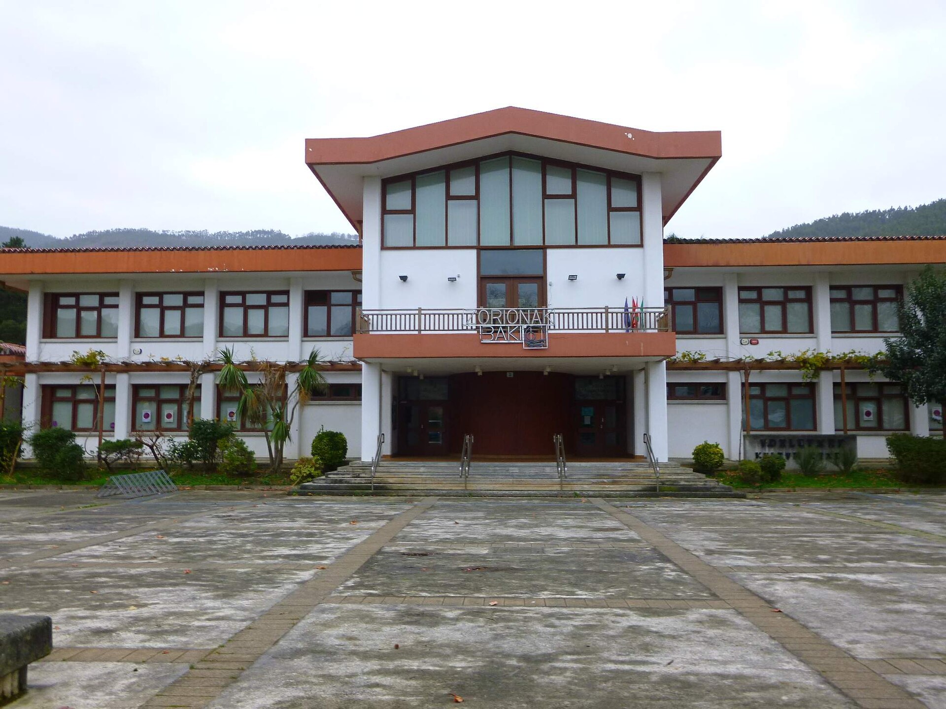
Ayuntamiento de Bakio is the town hall of Bakio, a coastal municipality in Biscay, in the Basque Country, best known as one of the most popular surf spots on the Bay of Biscay coastline. Where is Bakio and what makes it stand out Bakio sits on the Cantabrian coast between Bilbao and the Gaztelugatxe peninsula. The municipality is known for its long beach, considered one of the longest in the whole of Biscay, and for txakoli, a light, dry white wine grown on the surrounding hillsides. The town hall itself sits in the town centre, close to the seafront promenade and the main services, making it a natural landmark for anyone exploring the area. Is Bakio a good spot for surfing Yes, it is arguably the town's biggest draw. The beach faces the open ocean, so waves break here nearly year-round regardless of season. It has three distinct zones: a western section with a powerful right that only breaks on bigger swell days, and the areas known locally as El Callejón and Peñas Rojas, where a mix of sandy and rocky bottom produces quality left and right breaks. Bakio has a local surf club and surf schools, which makes it accessible for beginners and experienced surfers alike. What is worth seeing near the town hall The town centre itself has the layout typical of small Basque coastal towns, with a promenade running the length of the beach. A few kilometres from the centre, on the slope of Mount Burgoa, stands the Church of San Pelayo, a small Romanesque church dating from the second half of the 12th century and considered one of the oldest surviving Christian buildings in Biscay. Built from ashlar masonry, it has kept its original layout despite centuries of use and later work, including a restoration of the roof, choir, and sacristy carried out in 1957. Is it easy to reach Gaztelugatxe from Bakio Yes, and this is one of the location's biggest advantages. The famous islet of San Juan de Gaztelugatxe, connected to the mainland by a stone bridge and a stairway leading up to the hermitage at its summit, lies a short distance from Bakio and is a common day-trip destination for visitors staying in the town. That proximity makes Bakio a convenient base for exploring one of the most recognisable landmarks on the Biscay coast. Frequently Asked Questions Is Bakio beach suitable for beginner surfers? Yes. With local surf schools and multiple breaks ranging from gentler to more demanding, the beach caters to surfers at different skill levels. What else can visitors do in Bakio besides surfing? Kayaking and beach volleyball are both popular, and walking the seafront promenade is an easy way to see the town. Is there anything worth visiting in Bakio beyond the beach? Yes, the Romanesque Church of San Pelayo on Mount Burgoa is one of the oldest surviving religious buildings in Biscay, and the town's proximity to Gaztelugatxe makes it a useful base for day trips. Does Bakio's beach have any official water quality certification? Bakio beach holds a Blue Flag, the only beach in Biscay with this certification, which confirms high standards for water quality and facilities.
-
Erandioko udaletxea - Ayuntamiento de Erandio
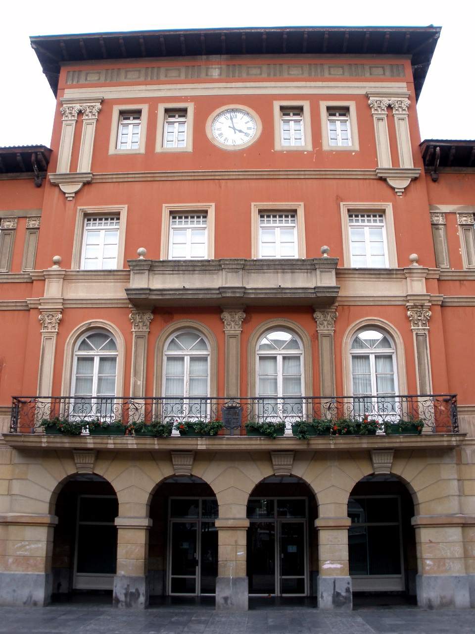
Erandio Town Hall (Ayuntamiento de Erandio) is the seat of local government for Erandio, a town in Biscay, in the Basque Country, sitting on the banks of the Nervión estuary a short distance from Bilbao. What does the town hall building look like? The building follows a symmetrical layout split into two clearly separate sections: an administrative wing and a wing that historically housed the local schools — a combination common in Basque town halls of the period, when municipal government and public education often shared a single structure. The exterior is sober and solid, built largely of stone. The different floors are clearly marked by moulded cornices running along the façade, and the ground floor opens onto a wide, continuous portico stretching the full length of the building — a feature typical of Baroque-era town halls in the region. How old is the building, and what came before it? Erandio had no casa consistorial of its own until the end of the 18th century, and the building standing today was not completed until the closing decades of the 19th century. The town's original settlement core, known as Erandiogoikoa, was essentially rural and grew up around the church of Santa María (Andra Mari in Basque). It was only well into the 19th century, driven by growing industrial activity along the estuary, that Erandio began expanding toward the water — a shift that reshaped the town for the century that followed. What else is worth seeing near the town hall? The best-preserved historic building in the municipality is the church of Andra Mari, considered one of the more notable Gothic structures in Biscay. Standing right beside it is the Martiartu tower, the other key landmark of pre-industrial Erandio. Beyond these two sites, the older parts of town still show their rural roots: stone defensive towers, centuries-old farmhouses (caseríos), and scattered religious buildings sit alongside views over the estuary that recall the area's later industrial past. Where exactly is Erandio located? Erandio lies right at the heart of the Nervión estuary, flanked by the hills of San Pablo and San Bernabé, within the wider Uribe Kosta–Txorierri area of Biscay. Its position on the water shaped its history at every stage — first as a rural parish, later as a hub tied to riverside and port-related industry — and its closeness to Bilbao makes it an easy addition to a visit centred on the Biscay capital. Frequently Asked Questions What is Erandio Town Hall? It is the seat of Erandio's municipal government in Biscay, a building that also serves as one of the reference points of the town centre. When was the current town hall built? The building in its present form dates from the end of the 19th century; before that, Erandio had no dedicated casa consistorial at all. What else can visitors see in Erandio besides the town hall? The Gothic church of Andra Mari is the town's best-preserved historic landmark, and the neighbouring Martiartu tower represents the pre-industrial period of Erandio's history. How far is Erandio from Bilbao? Erandio sits on the Nervión estuary between the San Pablo and San Bernabé hills, close enough to Bilbao that the two are easily combined in a single visit.
-
Ayuntamiento de San Fernando de Henares
San Fernando de Henares
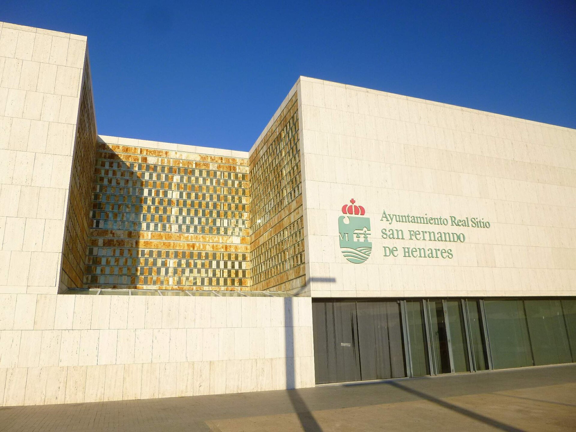
The Ayuntamiento de San Fernando de Henares is the town hall of San Fernando de Henares, a municipality in the Community of Madrid roughly 15 km east of the Spanish capital and directly on the route toward Barajas Airport. The building sits on Plaza de España, a formal square that, together with the adjoining Plaza de Fernando VI, has carried protected historic-artistic status since 1983. Why this square matters to the town San Fernando de Henares grew out of an 18th-century "Real Sitio," a planned settlement built around a royal residence on the banks of the Henares river. Plaza de España still follows that original symmetrical layout, and the town hall is one of the buildings that frames it. Anyone standing on the square is looking at more than a municipal office — they're looking at a surviving fragment of Bourbon-era town planning that has kept its shape for two and a half centuries. What to see around the town hall The square and its immediate surroundings form a natural short walking route: Paseo de los Chopos and Paseo de los Plátanos — tree-lined promenades that are part of the historic layout, good for a quiet walk after the square itself. The parish church on Plaza de España, one of the oldest religious buildings in town. Castillo de Aldovea, a fortress dating back to the Reconquest era (11th–12th century) and listed as a cultural heritage asset (BIC) since 1949 — a short drive away, but the most significant military monument in the municipality. Parque de Europa, a themed park with replicas of famous European landmarks such as the Eiffel Tower, a popular family stop just minutes from the centre. Getting there San Fernando de Henares has its own metro station on the line connecting the town directly to Adolfo Suárez Madrid–Barajas Airport, making it an easy stopover coming either from central Madrid or straight off a flight. The town also sits on the main roads of the Henares Corridor, so a car journey from Madrid's centre usually takes under 20 minutes outside rush hour. Is the town hall itself worth the visit The Ayuntamiento building is not a museum and has no visitor exhibition — it's a working seat of local government. Its appeal lies in context: it stands on a square with protected historic-artistic status, surrounded by 18th-century urban fabric, which makes it a natural stop on a short walk through the old town, particularly for travellers with time to spare between a Barajas flight and their onward journey. Frequently Asked Questions Can visitors go inside the town hall? The building serves administrative functions, so visitor access is limited to office hours and official business; the square itself and its surrounding architecture, however, are open to view at any time. How do I get there from Madrid without a car? The easiest way is the metro — San Fernando de Henares has a station on the line that runs to Barajas Airport, giving a direct connection from either direction. What else can I combine with a visit to the town hall square? A short walk along Paseo de los Chopos and Paseo de los Plátanos, and, with more time, a visit to Parque de Europa or a trip out to Castillo de Aldovea. Is the area around the square historic? Yes — Plaza de España together with Plaza de Fernando VI has held protected historic-artistic status since 1983, reflecting the town's 18th-century origins as a Real Sitio.
-
Ferrol City Council
Ferrol
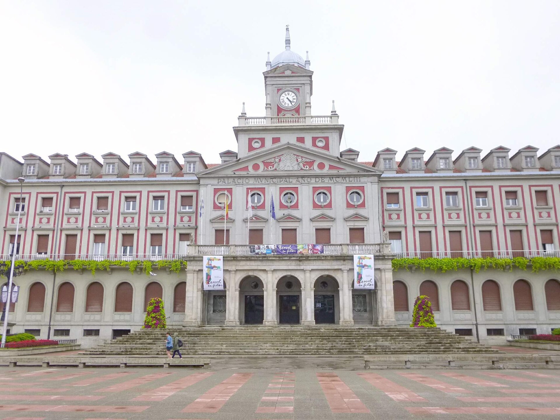
Ferrol City Council (Concello de Ferrol) is the seat of local government for Ferrol, a major naval port city in Galicia, and one of the town's architectural landmarks. The building, known locally as the Palacio Municipal, stands on Plaza de Armas — the central square of the rationalist Magdalena district, a neighborhood proposed for UNESCO heritage status as an example of "Atlantic Enlightenment" urban planning. What's the story behind the building? The current town hall opened on September 14, 1953, during the term of mayor José Manuel Alcántara Rocafort. It was designed by architects Vicente García Lastra and Nemesio López in what's commonly described as an "imperialist" style — a strand of mid-20th-century Spanish neoclassicism favored for civic buildings of that era. Before this building existed, the city council operated out of a structure on Cantón de Molíns, which was later demolished. What does the architecture look like? The façade is strictly symmetrical: a central portico with arcades leads to the entrance via a stone staircase, with a balcony set above the arcades. The composition is topped by a clock tower that gives the building a strong vertical presence on the square. Columns, pediments and domed elements reinforce the monumental, official character typical of representative architecture from that period. The building also houses Ferrol's Municipal Archive, which preserves historical documents relating to the city and the wider region. How do you get to Plaza de Armas? The square sits in the heart of Ferrol, within the Magdalena district — a grid of streets laid out in the 18th century and best explored on foot, with numerous examples of Galician civil architecture along the way. From the port area and the main city bus stops, it's a walk of about fifteen minutes to reach the square. It's worth setting aside extra time here, since Magdalena concentrates most of the city's historic townhouses and viewpoints over the old town. What else is worth seeing nearby? Plaza de Armas works as a natural starting point for exploring the rest of Magdalena — rows of townhouses with the district's characteristic enclosed balconies (galerías), nearby churches, and remnants of fortifications tied to the city's history as a naval base. As one of the largest and most recognizable buildings on the square, the town hall serves as an easy landmark when planning a walking route through the center. Can you visit the town hall's interior? Yes, though access is limited. The city's Department of Culture organizes guided tours on Wednesday afternoons, and advance booking by phone is required. Outside those hours, the interior isn't generally open to visitors, since the building functions as an active seat of municipal administration. When's the best time to visit? Ferrol and Plaza de Armas can be visited year-round, but late spring through early autumn tends to offer the most comfortable conditions for walking around the district. It's worth checking the local festival calendar too — during city celebrations, the square often hosts cultural events, which adds to the atmosphere but also brings larger crowds. Frequently asked questions Is entry to the town hall building free? The guided tours run by the Department of Culture are free, but they require booking in advance by phone. How do you book a tour? Reservations go through the city's Department of Culture at +34 981 944 000 (extension 382); tours take place on Wednesday afternoons. Is the town hall the only reason to visit Plaza de Armas? No — the square is the gateway to the whole rationalist Magdalena district, known for its distinctive civil architecture and the atmosphere of a working port city. Does the building carry historical significance beyond its administrative role? Yes — its 1950s "imperialist" architecture is a notable example of the representative civic style of that period in Spain, and Plaza de Armas itself has remained the focal point of public life in Ferrol for decades.
-
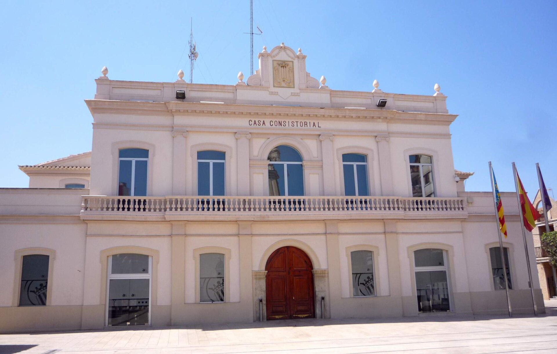
Alfafar town hall
Alfafar
Alfafar Town Hall stands at the heart of Alfafar, a small town in the l'Horta Sud district just a few kilometres south of Valencia city. The building sits at Plaça del País Valencià 1, directly facing the parish church, making it an easy landmark for anyone trying to get their bearings in the old town centre. What's the story behind the building? The casa consistorial dates back to the 19th century and is attributed to Sebastián Monleón, a Valencian architect best known for designing the Plaza de Toros in Valencia, one of Spain's most recognisable bullrings. If that attribution holds, the town hall connects Alfafar to a broader regional tradition of civic architecture that flourished across the Valencia area in the second half of the 1800s, when many local towns invested in representative seats of government built in the historicist style typical of the era. Inside, the building houses a painting by the Cuban painter Armando Menocal — an unusual detail for a town hall in a municipality of this size, and one that hints at the artistic ambitions of the local authorities when furnishing their headquarters. How do you get to Alfafar Town Hall? Alfafar lies directly south of Valencia and is well connected to the metropolitan area — a short drive of around fifteen minutes, plus regular local bus services linking the town to Valencia's wider public transport network. The town hall itself sits right in the centre, so the easiest approach is on foot from the main square, where most of the town's daily life — church, cafés, shops — is concentrated. What else is there to see nearby? The square in front of the town hall functions as Alfafar's natural centre, putting the parish church and other public buildings within easy walking distance. Despite the town's modest size, the town hall's architecture reflects a solid 19th-century civic style: a symmetrical façade, a formal entrance, and details typical of local administrative buildings from that period across the Valencia region. When is the best time to visit? Since the town hall is a working administrative building rather than a museum, the surrounding area is liveliest on weekdays during office hours, when the square and town centre see the most activity. Weekends are quieter in central Alfafar, but the façade and the square itself remain accessible at any time. Frequently asked questions Can you go inside Alfafar Town Hall? It's an active public administration building, so interior access is limited to official business during office hours. The façade and the square in front of it can be viewed year-round. Who designed the town hall building? Its construction is attributed to Sebastián Monleón, a Valencian architect also known for the Plaza de Toros in Valencia, though the detailed historical record would benefit from further verification. How do you get from Valencia to Alfafar? The simplest options are driving or public transport — the town sits right next to the regional capital, within the l'Horta Sud metropolitan area. What else is worth seeing in Alfafar besides the town hall? The parish church directly opposite the town hall, and the central square that anchors most of the town's community life.
-
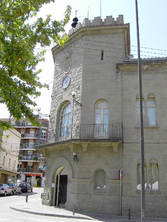
Parets del Vallès town hall
Parets del Vallès
The Parets del Vallès town hall (Ajuntament de Parets del Vallès) sits at the heart of Parets del Vallès, a town in the Vallès Oriental district, Barcelona province. It is one of the few buildings in town formally protected as local heritage, and its distinctive corner tower with two old bells is a familiar landmark for anyone walking through the historic centre. How do you get there? Parets del Vallès lies a short distance north of Barcelona, well connected by both road and commuter rail to the wider metropolitan area. The town hall stands right in the historic centre, at a corner where two streets meet, so it's easiest reached on foot from the main square or the pedestrian high street where most local shops and services cluster. Visitors coming from Barcelona can use the regional commuter train that links the Vallès Oriental towns to the city, then walk a few minutes into the centre from the station. What will you see? The building went up in 1949 to a design by architect Joaquín José García de Alcañiz, who at the time served as the municipal architect for nearby Granollers and had already designed several other buildings in Parets, including Villa Helga and the Sant Jaume church. For the town hall, he drew inspiration from the El Rincón palace in Aldea del Fresno. The result is a neo-Romanesque building set on a corner plot, with a chamfered façade aligned to follow both streets. The layout runs a ground floor and first floor along the wings, rising to two extra storeys in the corner section. The roof is mixed: the side wings are covered in Arabic tile, while the tower-like corner section has a flat roof edged by a crenellated parapet resting on a bold cornice. The tower is the building's signature feature — three visible faces, each pierced by a pointed arch. Hanging inside those arches are two forged bells cast in 1863, which previously belonged to the now-defunct Linera factory and, before that, to the Sant Esteve church. Those bells are part of what makes the tower such a recognisable point on the town's skyline. In 1986 the complex was expanded, with the adjoining Can Pau building converted into extra municipal offices. As a result, today's town hall blends the original 1949 façade with a newer administrative wing, without losing the character of the historic corner building. The town hall is listed as a cultural asset of local interest, meaning its façade, tower and architectural details are under heritage protection. When should you visit? The exterior can be admired year-round, and the building photographs best in the afternoon light, when the sun picks out the tower's detailing and crenellations. It's easy to combine a visit with a walk through the surrounding historic centre and a look at the nearby Sant Jaume church, designed by the same architect. If your trip coincides with local town festivities, it's worth checking the events schedule beforehand, since the adjacent square tends to be especially lively on those days. Frequently asked questions Who designed the Parets del Vallès town hall? Architect Joaquín José García de Alcañiz designed the building, completed in 1949, drawing inspiration from the El Rincón palace in Aldea del Fresno. What is the most distinctive feature of the town hall? Its corner tower, with three faces, pointed arches and two forged bells from 1863 that originally belonged to the Sant Esteve church. Is the town hall building protected? Yes, it is listed as a cultural asset of local interest, which protects its façade and architectural elements. Can visitors go inside the town hall? The building is in active administrative use, so interior access is limited to office hours and official business — the exterior architecture, however, can be viewed at any time.
-
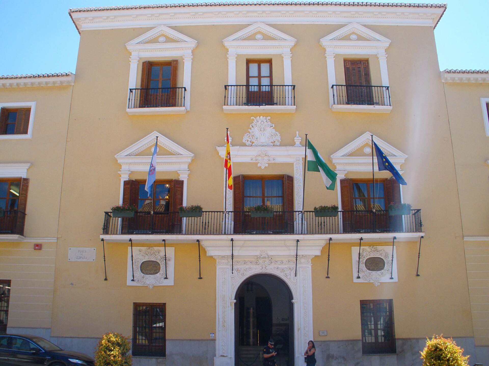
Motril town hall
Motril
Motril Town Hall (Ayuntamiento de Motril) stands on Plaza de España, right in the heart of the city, next to the church of Nuestra Señora de la Encarnación. It is one of the few buildings in Motril to have survived the many disasters that hit the city over the centuries, and it still serves its original purpose as the seat of local government. How do you get there? Plaza de España sits in Motril's historic centre, an easy walk of about ten to fifteen minutes from Playa de Poniente beach and the main shopping streets. The city has good bus connections to Granada, roughly 50 km inland, as well as to the other resort towns along the Costa Tropical, so getting there without a car is straightforward. Drivers will find several public car parks near the square — the plaza itself, lined with stone buildings, is best explored on foot. What will you see? The town hall was built in 1631, at a time when Motril was quickly growing in importance as a hub for sugar and other goods exported through the nearby port. Local authorities wanted a building that matched the town's rising economic standing, and the result was this Baroque casa consistorial, still standing today. One notable detail of the façade is a slight setback from the original street line — the town council agreed to pull the building back around 2.5 metres to widen the square. That decision gave Plaza de España the open, ceremonial feel it still has today. Inside, look out for the wooden coffered ceilings in the mudéjar style, a blend of Christian and Moorish decorative techniques typical of Andalusia. This artesonado work can be found above the main entrance and in the Sala de Juntas, the council chamber where meetings are still held. It's a detail easy to miss from outside, and one of the more interesting features of the interior. The square in front of the town hall functions as a natural gathering place for Motril's residents — local processions set off from here during festivals, and civic events are held on the plaza as well. Standing alongside the Encarnación church, the town hall forms a compact, historic architectural ensemble at the centre of the old town. When should you visit? The square and the town hall's façade can be seen year-round, while the interior, being an active administrative building, is really only accessible occasionally, during office hours on weekdays and usually for a specific reason. Plaza de España is at its most pleasant in the evenings, once the heat has eased and locals come out for a stroll, and during local festivals, when the square fills with decorations and music. The Costa Tropical enjoys a mild climate throughout the year, but spring and autumn are the most comfortable seasons for exploring the town, avoiding the hottest summer months. Frequently asked questions Can you go inside Motril Town Hall? The building houses the local government, so access to the interior is limited to office hours and usually tied to specific administrative business. The façade and the surrounding square, however, are open at all times. What's the most interesting architectural feature? The wooden mudéjar-style ceilings above the main entrance and in the council chamber are the detail most often singled out — a decorative technique typical of historic Andalusia, unusual to find in a public building of this size. How old is Motril Town Hall? The building dates from 1631, meaning it has stood on Plaza de España for nearly four centuries, continuously serving as the seat of local administration. What else is worth seeing nearby? The church of Nuestra Señora de la Encarnación stands right next to the town hall, and the square together with the surrounding old-town streets makes a good starting point for exploring central Motril on foot.
-
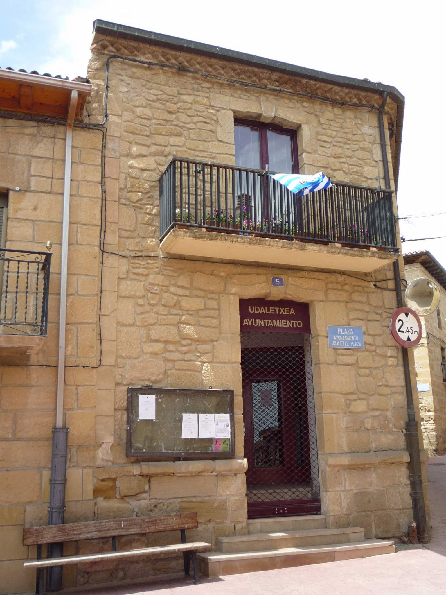
town hall of Baños de Ebro
Baños de Ebro / Mañueta
The town hall of Baños de Ebro (locally also known by its Basque name, Mañueta) is the seat of local government for a small municipality in Rioja Alavesa, in the province of Álava, Basque Country. The building stands at Plaza del Ayuntamiento 5, right in the heart of the village on the banks of the Ebro river. Where exactly is it located? Baños de Ebro / Mañueta is one of the smallest municipalities in Rioja Alavesa, with a population of around 300 and a surface area of under 10 km². The town hall sits on the village's main square, a layout typical of small towns in the region: the square in front of the municipal building functions as the social heart of the village, hosting local celebrations and community gatherings. The building's coordinates are 42.53014 N, -2.679489 W, making it easy to locate on a satellite map. How do you get there? Baños de Ebro lies at the heart of Rioja Alavesa, close to several better-known wine towns in the region. The easiest way to arrive is by car, using the local roads that connect the village with Laguardia and Logroño, the two main hubs for exploring the area. The square with the town hall sits within the old part of the village, so it's best to park at the edge and walk in — the stroll to the centre takes only a few minutes. What is there to see nearby? Agriculture, and specifically viticulture, is the backbone of the local economy in Baños de Ebro — vineyards cover roughly three-quarters of the cultivated land. Around the town hall square, visitors will find small stone houses, narrow streets, and views over the surrounding vine-covered hills, all giving a good sense of what a typical Rioja Alavesa village looks like. This is a spot for travellers who enjoy quiet, authentic wine-country scenery rather than grand monuments — the town hall itself is a working administrative building without a dedicated visitor programme. When is the best time to visit? Spring and autumn are the best seasons, when temperatures in Rioja Alavesa are mild and the vineyards look their best — vivid green in spring, and rich with harvest colours in autumn. Summers can be hot and dry, which makes longer walks around the village less comfortable. Keep in mind that, as a small rural municipality, Baños de Ebro has limited tourist infrastructure — it works best as a short stop on a route through the region's wine towns rather than a full day's destination on its own. Practical information The town hall serves residents of the municipality and handles the administrative functions typical of a village office of this size — it is not a museum or a heritage site open for indoor visits. Visitors are welcome to view the building from outside and walk around the adjoining square. Frequently asked questions Can you visit the inside of the town hall in Baños de Ebro? No, it is an active administrative building serving local residents, not a tourist site open to the public. How many people live in Baños de Ebro? The municipality has a population of around 300, making it one of the smaller villages in Rioja Alavesa. What is the local economy based on? Agriculture is the main activity, particularly viticulture — vineyards cover most of the municipality's cultivated land. What's the best way to get to Baños de Ebro? By car is easiest, using the local roads connecting the village to Laguardia and Logroño, the main gateways to exploring Rioja Alavesa.
-
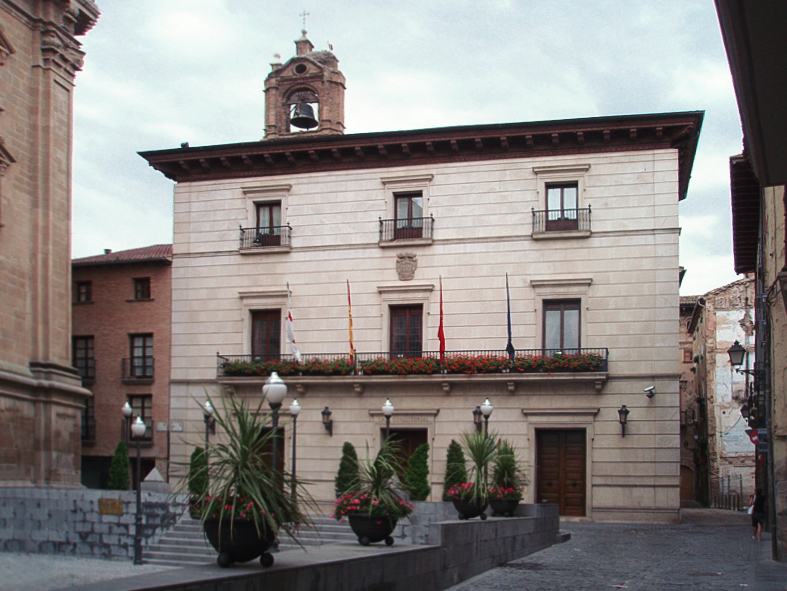
Tudela Town Hall
Tudela
Tudela Town Hall (Ayuntamiento de Tudela) is the seat of the local government of Tudela, in the Navarre region of Spain, standing on Plaza Vieja right next to the town's cathedral. Its façade reveals a building shaped by centuries of layered construction, from medieval foundations to a much later neoclassical makeover. How do you get there? The town hall sits at the heart of Tudela's old quarter, at Plaza Vieja 1, only a short walk from the cathedral and from Plaza de los Fueros, the other main square that together with Plaza Vieja forms the historic core of the city. Tudela is easiest to reach by train or bus from Pamplona (roughly 45–60 minutes) or from Zaragoza (a similar travel time). Once you're in town, the old center is compact and best explored on foot — narrow streets and traffic restrictions make driving through it impractical. What will you see? The town hall is actually made up of two joined buildings: a main block facing Plaza Vieja at the corner with Calle Cárcel Vieja, and a second one opening onto Calle Rúa. The three-story main façade stands out for its gallery of pointed arches and a projecting wooden eave, features that hint at the building's origins at the end of the 15th century, when it was raised on the site of the former Almudí houses belonging to Mosén Pierres de Peralta. The façade itself, though, was reworked around 1800 in a neoclassical style, so what visitors see today is really a blend of two very different periods — a Gothic-era structure dressed in classical lines. The interior and structure went through repeated repairs and alterations across the 17th, 19th, and 20th centuries, culminating in a thorough restoration in 1994 that recovered the original look of the façade, the entrance hall, the cellars, and the main halls. One lesser-known detail: the cellars of the main building served as the town jail from 1562 until 1841, a curious chapter in the building's long history. Standing in Plaza Vieja, it's worth taking in the whole ensemble — the square sits beside the cathedral, and together with the town hall it forms one of the most recognizable architectural groups in old Tudela. For centuries this has been the administrative and social heart of the city. When should you visit? Spring (April to June) and early autumn (September to October) are the most comfortable times to wander Plaza Vieja and admire the town hall's façade, since Navarre's summer heat can make extended walking uncomfortable. The building itself is a working municipal office, so its interior isn't open to casual sightseeing — most of what visitors experience is the exterior, best appreciated from the square and the surrounding streets of the old town. Frequently asked questions Can you go inside the town hall? The building is an active municipal office, so public access is limited to the areas open during working hours for administrative purposes. It isn't set up as a visitor attraction with regular interior tours. How old is the building? Its roots go back to the end of the 15th century, when it was built on the site of the former Almudí houses. The neoclassical façade visible today dates from a remodeling around 1800, and a full restoration took place in 1994. What else is worth seeing nearby? The cathedral of Santa María stands right beside the town hall, and Plaza de los Fueros along with the other historic streets of old Tudela are all within easy walking distance. Is it true the town hall was once linked to a jail? Yes — the cellars of the main building were used as the town's jail from 1562 to 1841, one of the more unusual facts tied to this landmark.
-
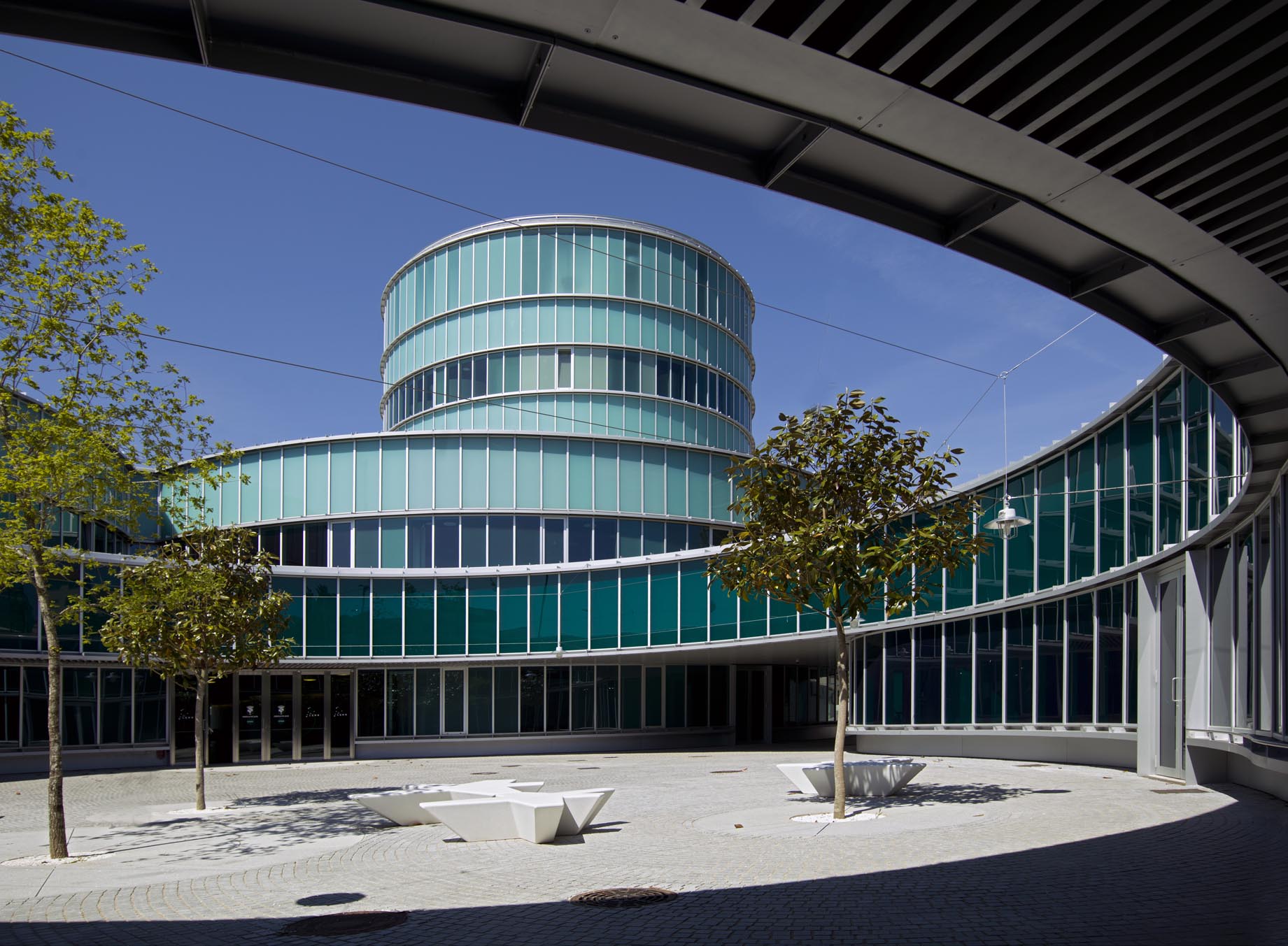
Lalín town hall
Lalín
Lalín Town Hall (Concello de Lalín) stands out among Galician municipal buildings not for its age but for its bold, modern design. Lalín is the largest municipality by area in the province of Pontevedra and one of the biggest in Galicia, and its town hall mirrors the ambitions of a town best known regionally for its Feira do Cocido festival. How do you get there? The building sits in the town centre, at Praza do Concello (Plaza de Galicia) 1. Driving is the easiest way to reach Lalín — the town sits on the route connecting Pontevedra with Santiago de Compostela and Ourense, putting it 30 to 60 minutes from most nearby Galician cities. Regular bus connections also run from Pontevedra, Santiago and Vigo. The town hall itself is within walking distance of the town's main sights, so no further transport is needed once you arrive. What will you see? What sets Lalín's town hall apart is its shape. Rather than the stone façades typical of many Galician towns, the building was designed as a cluster of round, glazed volumes. The project came from architects Luis M. Mansilla and Emilio Tuñón, whose studio drew inspiration from castros — the prehistoric, circular hillfort settlements scattered across the Galician landscape. The result has been described as a "technological castro," a form that links the region's archaeological heritage to a contemporary vision of public administration. The building is made up of several rounded volumes arranged around a shared public space, shaped to follow the natural terrain. Interiors are finished in concrete, while bright, glazed façades open the structure to its surroundings and let in generous natural light — a different feel from the closed-off municipal buildings found elsewhere. Look closely at how the individual segments connect: the layout was designed to feel open and non-hierarchical rather than imposing. The design has earned recognition well beyond the region — it was a finalist for the 2012 FAD Architecture Award and received a distinction at the 12th Bienal Española de Arquitectura y Urbanismo (BEAU) in the civic symbols category. It is unusual for a local government building to pick up national architecture awards, which alone makes it worth pausing at for a bit longer than a typical passer-by would. When should you visit? The town hall can be visited year-round, and its open, glazed design means it looks different depending on the time of day and the light — afternoons are especially rewarding, when sunlight catches the glass façades. If you're timing your trip around local events, the period of the Feira do Cocido is a good choice: this major gastronomic festival draws large crowds to Lalín and brings the whole town centre, including the square in front of the town hall, to life. Frequently asked questions Can you go inside Lalín's town hall? The building houses the local administration, so access indoors depends on office hours and ongoing municipal business. The exterior architecture and the open public space around the building can be viewed freely at any time. Who designed Lalín's town hall? The design is the work of Mansilla + Tuñón, the architecture studio led by Luis M. Mansilla and Emilio Tuñón, known for blending modern form with local historical context. What inspired the building's architecture? Its rounded shape references castros, the prehistoric fortified settlements characteristic of the Galician landscape — a concept the architects themselves called a "technological castro." Are there other attractions near the town hall? Yes. The square in front of the building is the town's central gathering point, close to the main shopping streets and to the sites associated with local traditions, including the Feira do Cocido festival.
-
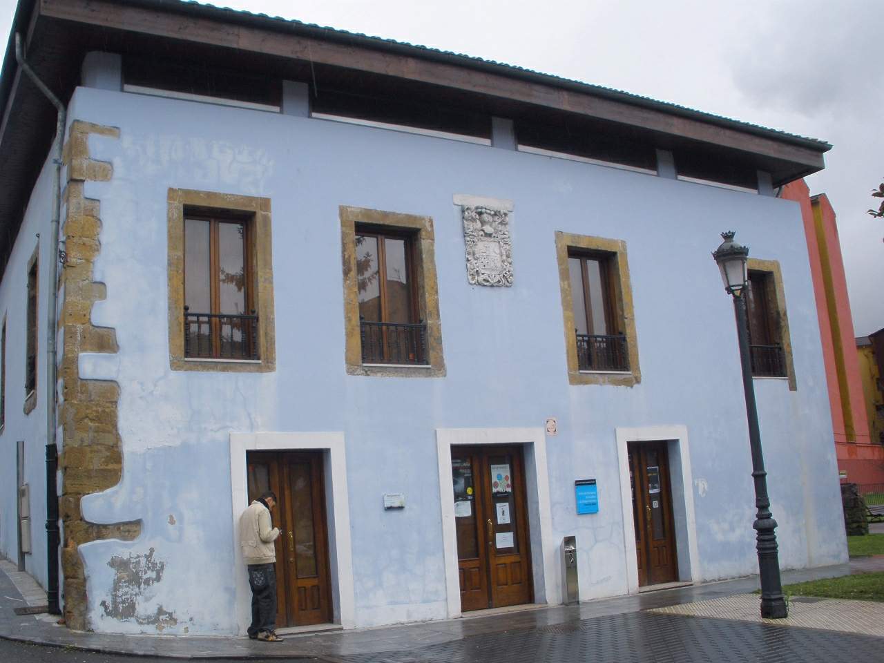
Casa de los Alberti
Llangréu / Langreo
Casa de los Alberti Casa de los Alberti is the oldest manor house in the Ciaño district of Langreo, in central Asturias. The building stands out against the surrounding industrial-era streetscape — it has been here since the 17th century, long before the valley turned into a mining and steelworking hub. What is the history behind the house? The house was built in the 17th century by the La Buelga family. Over the generations it went by several names tied to its successive owners, also being known as Casa de los García Bernardo and Casa de en medio ("the middle house"), a reference to its position among the other family residences in Ciaño. Its current name comes from Jaime Alberti, an Italian master foundryman who arrived to work at the ironworks in La Felguera in the late 19th century. He married Eladia García Bernardo, heir to the house, and the surname from that marriage is the one that stuck. In 2000 the family handed the building over to Langreo's city council. Since then it has operated as a public cultural space rather than a private residence — a notable shift for a house with more than three centuries of history. What will you see inside? Casa de los Alberti now functions as a Reference Centre for Asturian Culture and Language. Inside you'll find: a permanent exhibition run by the Nuberu Foundation, focused on Asturian culture, an exhibition room used for temporary shows, a conference room hosting talks and events, a press room, a library holding resources on the region's language and traditions. The site therefore has a double identity: it's a piece of civil architecture that documents the history of Ciaño's well-off families, and it's an active centre promoting Asturian (bable) as a living regional language. How do you get there? Casa de los Alberti sits in the Ciaño district of the municipality of Langreo, in the Nalón valley in central Asturias, at coordinates 43.287476, -5.668776. Langreo is close to both Oviedo and Gijón, and driving or taking a regional train or bus is the most practical way in — Ciaño has its own local transport stop connecting it to central Langreo. Given how compact the district is, once you arrive in Ciaño the house is easy to find on foot, near the old core of the settlement. When should you visit? Since the building operates as a cultural institution, weekdays are the more reliable choice, when exhibitions, talks, and events tied to the Asturian language actually take place — local holidays can mean reduced activity. Summer months (June to September) bring the most stable weather for exploring the region on foot, which makes it easy to pair a stop in Ciaño with other sights along the Nalón valley. Frequently asked questions What makes Casa de los Alberti different from other landmarks in Langreo? It's the oldest surviving manor house in Ciaño — most of the nearby buildings date from the 19th- and 20th-century industrial period, while this one goes back to the 1600s. Where does the house's name come from? From Jaime Alberti, an Italian master foundryman who, in the 19th century, married into the García Bernardo family that owned the house. Can you go inside? Yes — the building is a public cultural institution (the Reference Centre for Asturian Culture and Language), not a private home, so visitors can see the exhibitions and library. What's worth seeing nearby? Ciaño and the wider municipality of Langreo still carry traces of the Nalón valley's mining and steelmaking past, which makes the surrounding area a good complement to a visit at the house itself.
-
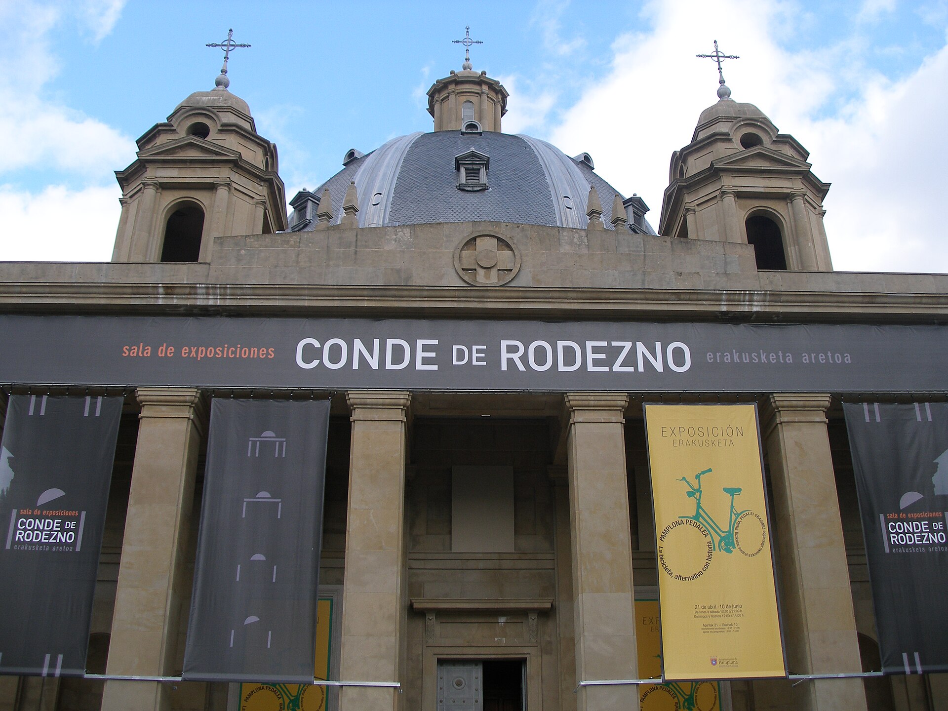
Monumento A Los Caídos
Pampeluna
Monumento a los Caídos is a monumental building in Pamplona, the capital of Navarre, raised as a memorial to those who died in the Spanish Civil War. Its full original name was "Navarra a sus Muertos en la Cruzada," though it is known today simply as the Monumento a los Caídos. The building went up in the Segundo Ensanche, the district created during the city's second wave of expansion beyond its medieval walls, and construction wrapped up in 1952 under architects José Yárnoz and Víctor Eusa. The memorial commemorates roughly 4,500 people from Navarre who died fighting on the Francoist side during the civil war. What will you see there? The building follows an austere, classicist style typical of large-scale commemorative architecture from that era in Spain. Its floor plan takes the shape of a Greek cross, topped by a massive central dome that is visible from many parts of the city. The sheer scale and rigid geometry give the structure a heavy, almost solemn presence — it ranks among the largest surviving Francoist-era memorials in the country, second in size only to the Valle de los Caídos complex near Madrid. Inside, the space occasionally hosts municipal exhibitions, and the building itself opens to visitors during special open days organized by Pamplona's city council. How do you get there? The monument sits in the Segundo Ensanche, the part of the city developed from the mid-20th century onward, just east of the historic old town. The district is well connected to the rest of Pamplona: it's a walk of roughly fifteen to twenty minutes from the old town center, and local bus lines run regularly through the area. Because it sits close to other landmarks from the same phase of the city's growth, the monument fits naturally into a walking route through the Ensanche's streets and squares. Why is this building controversial? For decades, the monument has stirred debate in Pamplona and across Navarre. As one of the clearest surviving symbols of the Franco era, it has repeatedly become a flashpoint in Spain's broader discussion about historical memory. In 2017, the city government launched an architectural competition aimed at transforming the building and the surrounding public space, seeking to change what the site represents. Discussions about its future — whether it should be redesigned, repurposed, or stripped of elements glorifying the dictatorship — continue to this day, and the site is still commonly described as one of the largest remaining Francoist monuments in Spain. When should you visit? Since the building isn't a standard tourist attraction with fixed opening hours, it's worth checking the city council's current events calendar — the interior is only accessible during occasional open days and exhibitions. The exterior can be viewed year-round, and the dome is especially striking in the afternoon light, when the sun brings out the geometry of the façade. Frequently asked questions Who designed the Monumento a los Caídos in Pamplona? The building was designed by architects José Yárnoz and Víctor Eusa, with construction completed in 1952. Who is the monument dedicated to? It commemorates around 4,500 people from Navarre who died on the Francoist side during the Spanish Civil War. Can visitors go inside? Yes, though only occasionally — Pamplona's city council organizes open days and exhibitions during which the interior becomes accessible to the public. Is this the only monument of its kind in Spain? No, but in terms of scale it is surpassed only by the Valle de los Caídos complex — it remains one of the largest surviving memorials from the Franco era in the country.
-
Walls of Burgos
Burgos
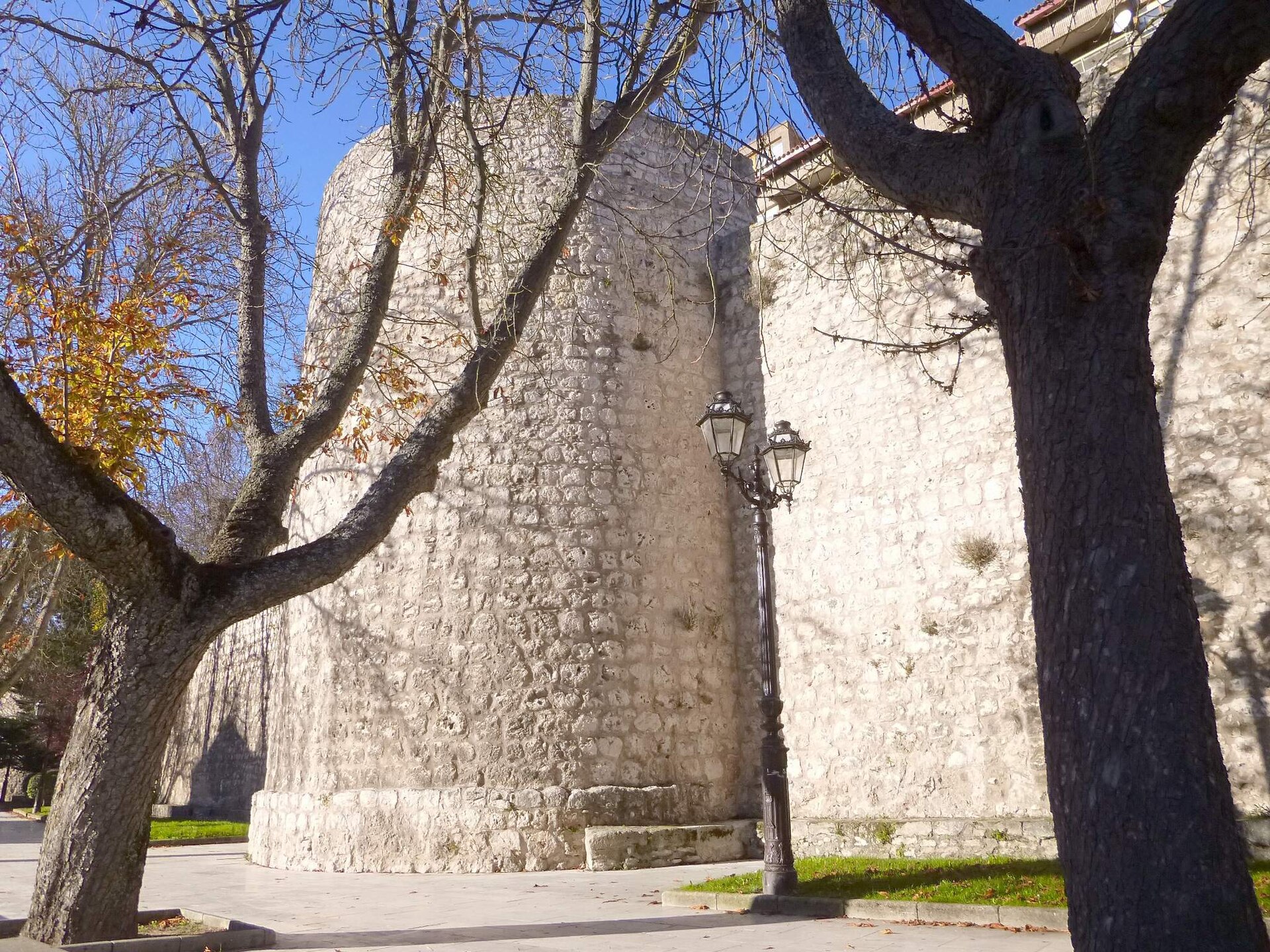
The Walls of Burgos (Spanish: Murallas de Burgos) are the surviving medieval fortifications that once enclosed the historic center of Burgos, in northern Spain. The earliest defenses on this site date back to shortly after the city's founding in 884, but the walls were substantially built up from the 13th century onward, eventually encircling the whole of the old town. Beyond military defense, the walls had administrative functions too: they controlled who entered and left the city, allowed authorities to collect tolls, and helped enforce public order and basic sanitation rules. Gates were shut at night, a common practice for fortified towns of the period. What survives today? Large sections of the fortifications were dismantled from the 18th century onward as the city expanded and the walls lost their defensive purpose. Even so, several stretches and gates have survived. The best-preserved and longest remaining section is the Paseo de los Cubos, a walking route along the old wall line where semicircular defensive towers — called "cubos" — alternate with connecting stretches of stone wall. Walking this route gives the clearest sense of what the fortifications looked like at their peak. Which gates are worth seeing? Of the original dozen or so gates, a handful remain. The most striking is the Arco de Santa María, originally a 14th-century gate and tower that was rebuilt in the 16th century on the orders of Emperor Charles V, as a gesture of gratitude to the city for its loyalty during the Revolt of the Comuneros. The remodeling was carried out by master builders Juan de Vallejo and Francisco de Colonia, who turned it into a Renaissance triumphal arch with a facade resembling a carved stone altarpiece. Its niches hold statues of Charles V, the legendary knight El Cid, and Diego Rodríguez Porcelos, credited as the city's founder. The gate building today houses a cultural center. Another key gate is the Arco de San Martín, historically the entry point used by the kings of Castile — which is why it is sometimes called the "royal gate." Also still standing are the Arco de San Gil, the Arco de San Esteban, and the gate that once led into the city's former Jewish quarter. How do you get there, and when should you visit? The walls and their surviving gates sit right in the center of Burgos, within easy walking distance of the cathedral and the city's main sights, so the simplest way to reach them is on foot. Walking the Paseo de los Cubos stretch is an easy, level stroll that typically takes 30 to 45 minutes and pairs naturally with a broader walk through the old town. Since the site is an open-air outdoor route accessible year-round, the most comfortable times to visit are morning or late afternoon, avoiding the midday heat in summer and catching better light for photos. What will you see on site? Along the surviving stretches you'll find the characteristic semicircular defensive towers, sections of stone wall now woven into the surrounding modern city, and the standout gates — especially the Arco de Santa María, which is worth viewing from both sides: it looks noticeably different from the riverside of the Arlanzón than from the old town side. The wall route also offers good vantage points over the rooftops of Burgos. Frequently asked questions Is visiting the Walls of Burgos free? Yes — walking along the surviving sections and viewing the gates from outside is free, since they form part of the open public streetscape. How much time should I set aside? Walking the Paseo de los Cubos and taking in the main gates typically takes between thirty minutes and an hour, depending on pace and how many photo stops you make. Is it worth going inside the Arco de Santa María? Yes — the gate building now operates as a cultural center and periodically hosts exhibitions related to the city's history. Is the area accessible for visitors with limited mobility? The Paseo de los Cubos itself is a paved walking path, but some of the surrounding old-town streets near the gates have uneven, historic paving, which is worth factoring into route planning.
-
Arco de Santa María
Burgos
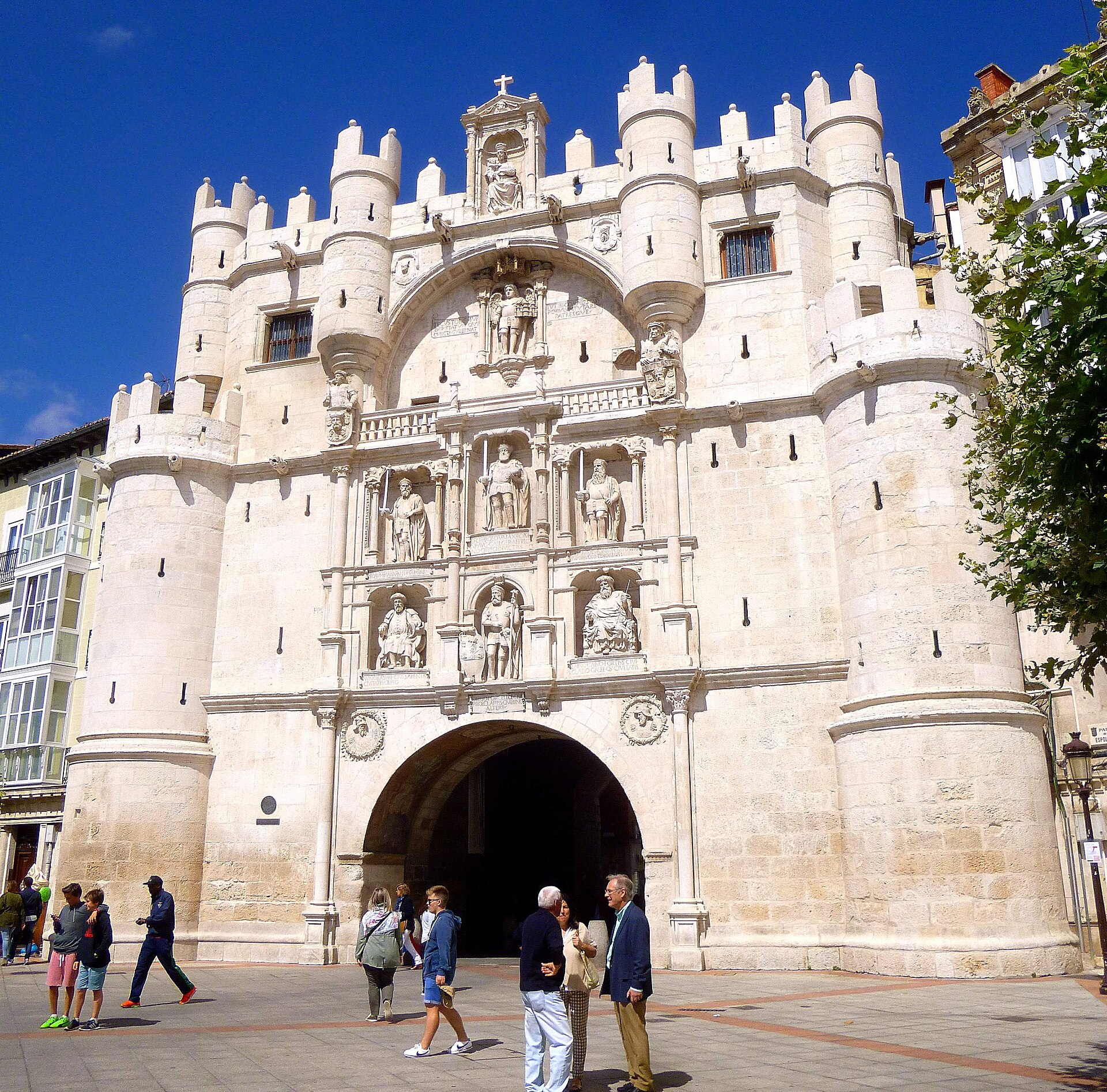
Arco de Santa María is a monumental city gate in Burgos, one of twelve that once guarded the medieval city and today the most recognizable entrance to its historic center. What is the history behind the gate? The original gate was part of Burgos's defensive city walls. It gained its current, monumental appearance in the 16th century, when it was rebuilt on the orders of Emperor Charles V. This rebuilding wasn't arbitrary: the citizens of Burgos had backed the emperor during the Revolt of the Comuneros, and the renewed gate became a kind of thank-you and a public statement of the city's loyalty to the crown. What had been a defensive structure turned into a ceremonial triumphal arch, dressed in an elaborate stone facade. What will you see on the facade? The facade reads like a stone gallery of figures central to the history of Burgos and Castile. Charles V occupies the middle position, flanked by two men of deep regional significance: Count Fernán González, regarded as the founder of Castile's independence, and El Cid, the most famous knight of medieval Spain and closely tied to Burgos. Above them stand Laín Calvo and Nuño Rasura, the legendary 9th-century "Judges of Castile," who by tradition are the forefathers of El Cid and Fernán González respectively. Completing the composition is Diego Rodríguez Porcelos, credited with founding Burgos in 884. Together, the figures form a kind of history lesson carved in stone — from legendary origins, through the age of the Castilian counts, to the Habsburg era. How do you get to Arco de Santa María? The gate stands right in the center of Burgos, on the bank of the Arlanzón river, and serves as the natural gateway into the old town from the Puente de Santa María bridge. It's an easy walk of a few minutes from most hotels in the city center. It also makes a convenient starting point for further sightseeing, since Burgos Cathedral and other landmarks of the historic center are just a short walk away. When is the best time to visit, and how long does it take? The gate can be viewed at any time, since it's part of the open cityscape with no fixed opening hours. The best light for photographing the facade is early morning or late afternoon, when the sun hits the stone figures at an angle that brings out the carved detail. A visit typically takes just a few minutes, but it's worth pairing it with a walk along the Arlanzón river and further exploration of the old town. Frequently asked questions Is there an entrance fee for Arco de Santa María? No. It's a piece of urban architecture viewed from the outside, with no ticket or booking required. Who are the figures on the facade? Charles V stands at the center, flanked by Fernán González and El Cid, with the legendary Castilian judges Laín Calvo and Nuño Rasura above them, alongside Diego Rodríguez Porcelos, the city's founder. Why was the gate rebuilt specifically in the 16th century? Because the people of Burgos supported Emperor Charles V during the Revolt of the Comuneros, and the rebuilt gate was meant to showcase the city's loyalty to him. Is it easy to combine with other Burgos sights? Yes. The gate sits right in the center, close to the cathedral and the main landmarks of the old town, making it a natural stop on any walking route through the historic quarter.
-
Jean-Jacques Laffont
Tuluza
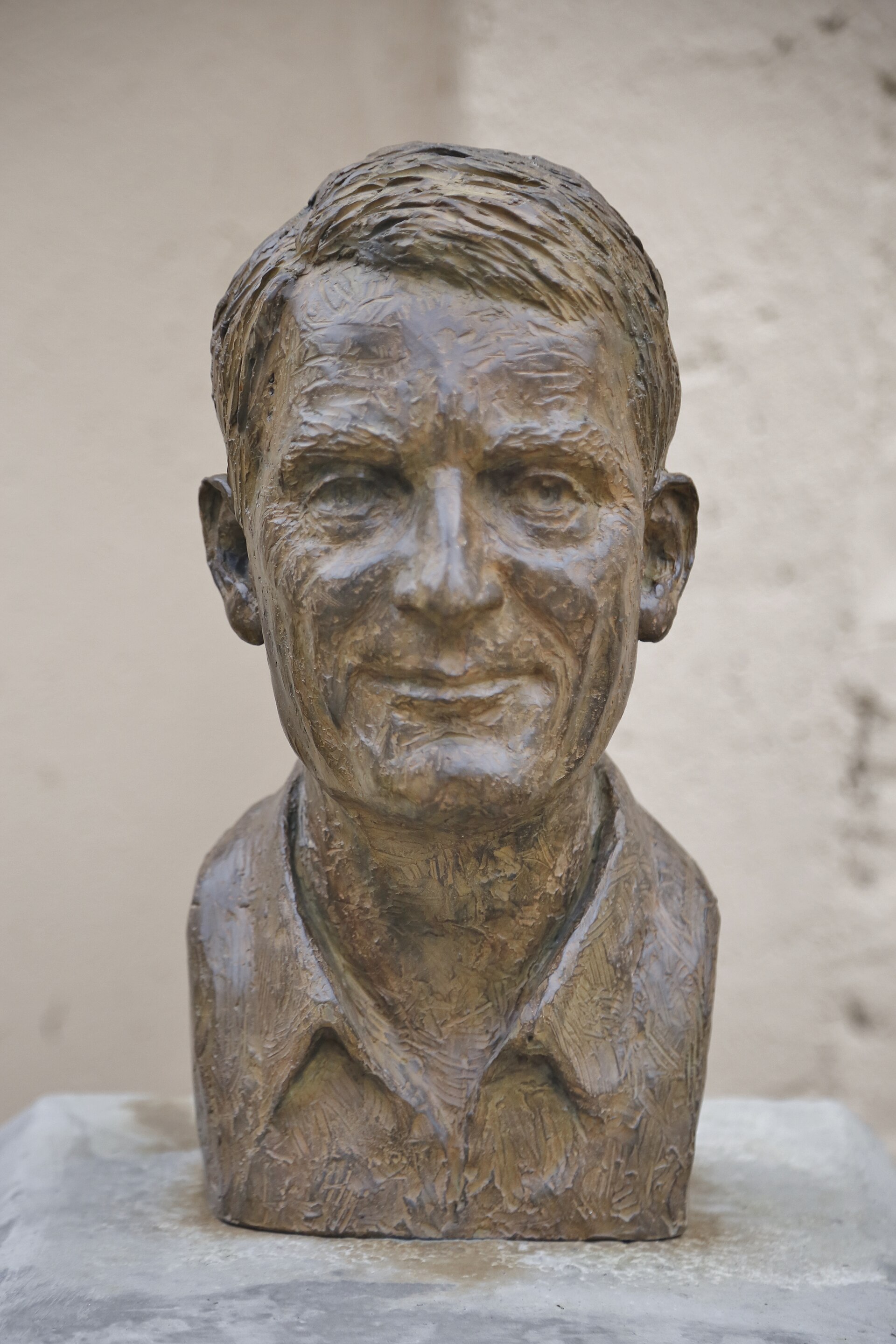
Jean-Jacques Laffont lends his name to the main auditorium of the Toulouse School of Economics (TSE), a modern university building in the heart of Toulouse, on Rue du Doyen-Gabriel-Marty, close to Place Saint-Pierre. It is a spot where the history of modern economics meets striking contemporary architecture, offering visitors a different angle on the city beyond its more traditional monuments. Who was Jean-Jacques Laffont? Jean-Jacques Marcel Laffont (1947–2004) was a French economist who specialized in public economics and information economics. He studied at the University of Toulouse and at the École Nationale de la Statistique et de l'Administration Économique (ENSAE) in Paris, and earned his PhD in economics from Harvard University in 1975. Back in Toulouse, he founded the Institut d'Économie Industrielle (IDEI), a research institute that became the seed from which the Toulouse School of Economics grew into one of the most respected economics faculties in the world. What can you see here? The Jean-Jacques Laffont auditorium is the main hall of the TSE building, used for lectures, conferences and academic events. The building itself, which the school moved into in 2019, sits right in the center of Toulouse near the historic Place Saint-Pierre and stands out for its contemporary design — the project won the prestigious French architecture prize Équerre d'Argent in 2020. Besides the auditorium, the building also has a wing bearing Laffont's name, housing facilities for the school's doctoral program in economics. Visitors exploring Toulouse should know this is not just any lecture hall — the university dedicated it specifically to honor its most internationally recognized economist. The building's open, city-facing design, blending academic function with public space, is a good example of how Toulouse invests in 21st-century academic architecture. Why does this place matter? The auditorium was formally inaugurated and dedicated to Jean-Jacques Laffont on 14 September 2022, in a ceremony attended by leadership of Université Toulouse Capitole, the directors of TSE, and members of the economist's family. The tribute recognized his central role in building what the university calls "the project of Toulouse economists" — the research community that turned the city into one of the world's leading centers for economic research, alongside places like Cambridge or Chicago. How to get there? The TSE building is centrally located in Toulouse, an easy walk from Place Saint-Pierre and the old town. It makes a natural stop for combining a stroll through Toulouse's historic center — with its pink-brick facades, churches and the banks of the Garonne — with a short look at this modern economics campus. Its downtown location means no special transport is needed; most central landmarks are within walking distance. When to visit? Since the auditorium is part of an active university, the building feels most alive during the academic year, when lectures and events fill the space. That said, the architecture and surroundings can be admired from the outside year-round, and a walk through this part of Toulouse pairs well with visits to the city's more classic historic sites nearby. Frequently asked questions Who was Jean-Jacques Laffont? A French economist (1947–2004) specializing in public and information economics, a Harvard PhD, and founder of the Institut d'Économie Industrielle in Toulouse. What exactly carries his name in Toulouse? The main auditorium of the Toulouse School of Economics building, along with a wing housing the school's doctoral program facilities. When was the auditorium dedicated to him? It was formally inaugurated on 14 September 2022, with the university's leadership and the economist's family in attendance. Is the TSE building itself worth seeing? Yes — the school's building, occupied since 2019, won the Équerre d'Argent architecture award in 2020 and stands near Place Saint-Pierre in central Toulouse.
-
Simón Bolívar
Bilbao
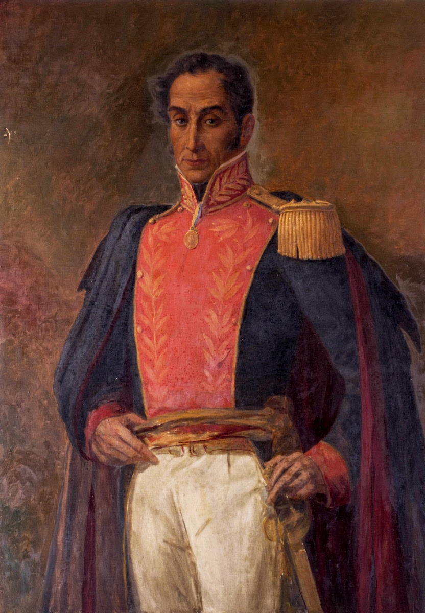
Simón Bolívar is a bust-monument in Bilbao, standing on Plaza de Venezuela in the Abando district, right by the bridge next to the town hall. It honors the Venezuelan military leader and statesman who led South America's wars of independence — a man who also happened to spend more than a year living in Bilbao at the turn of the 19th century. Where is the Bolívar monument in Bilbao? The bust stands on Plaza de Venezuela, a small square in Abando on the right bank of the Nervión river, close to the Ayuntamiento bridge by the city hall. It sits in the heart of the city, an easy walk from Abando station and the riverside promenades. The square's name is no coincidence — it was Venezuela that funded and pushed for the monument in the first place. What will you see there? On a pedestal stands a bust of Simón Bolívar, the work of sculptor L. Ibarra. The translucent base carries an inscription recalling that Bolívar liberated Venezuela, Colombia, Ecuador, Peru, Bolivia and Panama, and describing the statue as a token of friendship between Venezuela and Bilbao. It's a modest but symbolically loaded piece of public art, listed as one of the stops on Bilbao Turismo's outdoor art route ("Arte al Aire Libre"). What is the history behind the monument? The sculpture was unveiled on 18 October 1989, commissioned and sponsored by the Venezuelan government as a gesture of friendship toward Bilbao. An identical copy of the bust stands in La Puebla de Bolívar (Cenarruza, Biscay), the ancestral home of the Bolívar family before they emigrated to the Americas. Having the same monument in both Bilbao and the family's ancestral village underlines the Basque roots of the famous Liberator. What connection did Bolívar have with Bilbao? Simón Bolívar lived in Bilbao between 20 March 1801 and 29 April 1802, during a longer stay in Spain before his eventual departure for the Americas. A commemorative plaque on a building on Calle Banco de España, in the old town (Casco Viejo), marks the house where he resided. A street in Bilbao also carries his name, further weaving the Liberator into the city's everyday geography. How do you get there? Plaza de Venezuela sits right in central Bilbao, in Abando — the district that also holds the railway station, banks and offices. It's an easy walk from Gran Vía or the riverside; metro and tram stops in Abando are just a few minutes away on foot. The square pairs well with a visit to Casco Viejo, home to the plaque marking Bolívar's former residence. Frequently asked questions What is the Simón Bolívar monument in Bilbao? It's a bust of the Venezuelan independence leader, standing on Plaza de Venezuela in the Abando district, unveiled in 1989 at the initiative of the Venezuelan government. Did Bolívar really live in Bilbao? Yes — he lived there between March 1801 and April 1802; a commemorative plaque in the old town (Casco Viejo) marks the site of his former residence. Is there another Bolívar monument nearby? Yes, an identical copy of the bust stands in La Puebla de Bolívar (Cenarruza), the ancestral home of the Bolívar family before they moved to the Americas. How do you reach the monument? Head to Abando and Plaza de Venezuela — it's a few minutes' walk from Abando station and the Nervión riverside, right in the center of Bilbao.
-
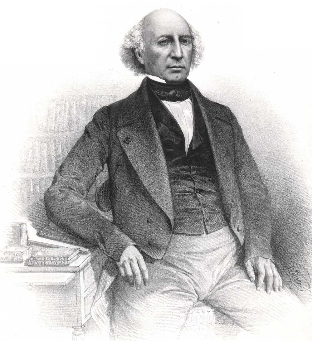
Mathieu Orfila
Maó
José Matteo Bonaventure Orfila is a name inseparably linked with Maó, the capital of Menorca — the town where, in 1787, the man later regarded as the father of modern toxicology was born. Who was José Matteo Bonaventure Orfila? Mateu Orfila i Rotger, later known in France as Mathieu Orfila, was born on 24 April 1787 in Maó. After his early studies he moved to France, where he built his entire scientific career in Paris. He became a professor of legal medicine and one of the most influential chemists and physiologists of his era. His research into how poisons act on the human body laid the foundations of toxicology as an independent scientific discipline, which is why he is remembered today as its founder. He died in Paris in 1853, leaving behind a body of work still referenced in forensic medicine. Why does his story matter for visitors to Maó? Walking through Maó today, it is worth remembering that this modest port town gave the world one of the most influential scientists of the 19th century. Orfila's name still appears in medical and chemistry textbooks worldwide, a striking legacy for someone raised in a relatively small Mediterranean town. Strolling along the old town's narrow streets and around the harbour gives a real sense of the setting that shaped a career that eventually reached the top academic chairs of Paris. What else is worth seeing in Maó? Maó carries a layered history spanning Roman times, British and French rule in the 18th century, and the modern day. At its heart lies the harbour — one of the deepest natural ports in the Mediterranean — surrounded by a compact old town of stone townhouses, churches, and narrow lanes climbing up toward the centre. It was in this setting that Orfila spent his early years, before leaving to pursue his education abroad. How to get to Maó? Maó is the capital of Menorca and the island's main transport hub. It has an airport with connections to numerous European cities, especially during the summer season. Ferries also link Maó with Barcelona and Palma de Mallorca. The town itself is compact and best explored on foot, starting from the harbour area. When is the best time to visit? Spring (April to June) and early autumn (September to October) are the best times to visit Maó, offering milder temperatures than the height of summer and fewer crowds. Summer draws the largest number of visitors thanks to Menorca's beaches, but also brings higher prices and busier streets. Frequently Asked Questions Who was José Matteo Bonaventure Orfila? He was a French physician, chemist and physiologist born in Maó, regarded as the founder of modern toxicology and a professor of legal medicine in Paris. Where and when was he born? He was born on 24 April 1787 in Maó, the capital of Menorca. What was his main contribution? He studied the effects of poisons on the human body, taught legal medicine in Paris, and authored works considered the foundation of toxicology as a science. Can visitors learn about him in Maó? Yes — as his hometown, Maó is a natural starting point for learning about his life, although the main stage of his career was Paris.
-
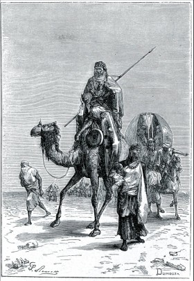
Benjamin of Tudela
Tudela
Benjamin of Tudela remains the most celebrated native of Tudela in the city's long history, and a monument in his hometown keeps that legacy visible today. This 12th-century Jewish traveler, son of a rabbi, set out from Tudela sometime in the third quarter of the 1100s (commonly dated around 1160–1173) on a journey that took him along the Mediterranean coast and across the Middle East as far as Baghdad, with his account also drawing on reports of Jewish communities in more distant parts of Asia. The result, "Sefer ha-Masa'ot" (Book of Travels), known in Latin as "Itinerarium," stands as one of the richest surviving sources on the medieval Jewish world and Mediterranean geography — written nearly a century before Marco Polo's better-known account. Who was Benjamin of Tudela? Benjamin was born in Tudela into a family with strong religious roots; his father was a rabbi. Educated and widely read, he chose to record not just his route but the life of the Jewish communities he encountered along the way — their numbers, occupations, religious institutions, and standing with local authorities. His notes cover more than three hundred places, some visited in person, others described from accounts given by merchants and fellow travelers he met on the road. Where is the monument in Tudela? A bust of Benjamin of Tudela stands in Plaza de la Judería, a square in the city's former Jewish quarter that still bears traces of Tudela's Sephardic past. It's a fitting spot to honor the community's most famous son. The city also has a street named after him, Calle Benjamín de Tudela, and a secondary school, IES Benjamín de Tudela — his name is woven into the fabric of the city well beyond a single plaque. What else is worth seeing nearby? A visit to the monument pairs naturally with a walk through the rest of Tudela's old town — the Santa María cathedral, the bridge over the Ebro river, and the narrow streets of the former judería, where the medieval street layout is still easy to trace. It's a compact but historically dense part of the city, easily covered on foot in an hour or two. How to get there? Tudela sits in the region of Navarre, well connected by train and road to Pamplona and Zaragoza. The square with the monument lies within the historic center, within walking distance of the main old-town sights and the train station. When to visit? Spring and autumn offer the most comfortable conditions for exploring, since summer temperatures in the Ebro valley can run high. The city also comes alive during local cultural festivals that draw on Tudela's multicultural history. Frequently asked questions Who was Benjamin of Tudela and why does he matter? He was a medieval Jewish traveler born in Tudela, author of one of the oldest surviving travel accounts covering the Mediterranean world and the Middle East — a valuable source on 12th-century Jewish communities. Where exactly is his monument located? In Plaza de la Judería, in Tudela's historic center, within the city's former Jewish quarter. Are there other places in Tudela connected to him? Yes — a street, Calle Benjamín de Tudela, and a school, IES Benjamín de Tudela, both carry his name, and his legacy also features in local walking routes through the old judería. How much time should I set aside for this spot? The monument itself takes only a few minutes to see, but it's worth combining with a walk through the old town — plan for one to two hours depending on your pace.
-

Charles III of Navarre
Tudela
Charles III the Noble is honored with a bust in Tudela, a monument to the medieval king who shaped this Navarrese city's fortunes more than any other ruler. It stands in the historic quarter, close to a street that also bears his name, giving visitors a small but meaningful stop before exploring the old town further. Who was Charles III the Noble? Charles III reigned as King of Navarre from 1387 to 1425. He was the son of Charles II the Bad and Joanna, daughter of the French king John II the Good. Before inheriting the Navarrese crown he held the title of Count of Évreux (1387–1404) and later Duke of Nemours (1404–1425). His marriage to Eleanor, daughter of King Henry II of Castile, put an end to years of conflict between the two kingdoms, and the 1404 Treaty of Paris settled his disputes with France over the Navarrese crown's territories there. In 1423 he created the title of Prince of Viana for the heirs to the throne, first granted to his own son. What ties this king to Tudela? Charles III's reign marked a turning point for Tudela itself. On 20 May 1390 he formally granted the settlement the status of city, an act still preserved in the municipal archive and regarded as the moment that defined Tudela's identity. He also ordered a major rebuilding of Tudela's old castle, turning the fortress into a lavish royal residence. On 18 April 1407, while staying in the city, he established the merindad (administrative district) of Olite — a sign of how frequently the king made Tudela one of his bases. What will you see at the monument? The bust of Charles III the Noble is a modest but telling landmark in the old town's streetscape — worth a brief pause before heading deeper into Tudela's historic core. Nearby runs Calle Carlos III el Noble, named after the king, and from there it's an easy walk to the Santa María la Mayor cathedral, the former Jewish quarter (judería), and the banks of the Ebro River that trace the city's ancient urban layout. How do you get to Tudela? Tudela sits in southern Navarre, roughly 90 km from Pamplona and just under 80 km from Zaragoza. The easiest routes are the AP-15 motorway or the N-121 road, and travelers by train can use Tudela's station, served by connections to Pamplona, Zaragoza, and Madrid. From the station it's only a short walk of about fifteen minutes to the town center where the monument stands. When is the best time to visit? The Ebro valley is known for hot, dry summers, so spring and autumn bring the most comfortable conditions for exploring, along with a quieter old town. July draws crowds for the Fiestas de Santa Ana, one of the city's biggest celebrations, though visitors should expect both heat and heavier tourist traffic during that period. Frequently asked questions Who was Charles III the Noble? He was King of Navarre from 1387 to 1425, son of Charles II the Bad, remembered for reshaping his kingdom's administration and architecture. Why is he honored specifically in Tudela? Because in 1390 he granted Tudela the status of city and converted its castle into a royal residence, decisions that shaped the town's development for centuries. Is there an entrance fee for the monument? No — the bust stands in a public open-air space and can be viewed free of charge at any time. What else is worth seeing nearby? The Santa María la Mayor cathedral, the former Jewish quarter, and the banks of the Ebro River are all within a short walk of the monument.
-
José Ortega y Gasset
Madryt
José Ortega y Gasset is a monument in Madrid honoring one of the most influential Spanish thinkers of the 20th century. It's an unassuming presence in the cityscape, but behind the name stands a figure whose ideas reached well beyond Spain and shaped European philosophy in the first half of the last century. Who was José Ortega y Gasset? Ortega y Gasset was a philosopher and essayist active during a turbulent stretch of Spanish history, as the country swung between monarchy, republic and dictatorship. His thought is often described as a "philosophy of life," rooted in a pragmatist metaphysics inspired by William James and developed through a realist phenomenology in the spirit of Edmund Husserl. Out of that combination came his own distinctive path — close to proto-existentialism and to a realist historicism that scholars compare to the work of Wilhelm Dilthey and Benedetto Croce. It's this intellectual legacy that earned him a place among the philosophers commemorated in the Spanish capital's public spaces. Why a monument in Madrid? Madrid was the natural setting for such a tribute: it's where Ortega y Gasset wrote, published and took part in the country's intellectual life at a time when Spain was searching for its own political and cultural identity. The monument bears his name and works as a reference point for anyone interested in the history of Spanish philosophical thought, not just the city's classic architecture or landmarks. What should visitors expect? This is a low-key spot — not a major tourist draw with crowds, but a point of interest for travelers looking to trace the city's intellectual history rather than its monuments in the usual sense. It's best treated as an invitation to learn more about the philosopher's work rather than a destination in its own right. For anyone touring Madrid with an eye on 20th-century Spanish culture and ideas, it makes for a worthwhile addition to the route. How to get there and when to visit? The monument sits within Madrid's urban fabric, reachable on foot or by public transport like most points of interest in the Spanish capital. Since it's an outdoor site, daytime visits in good weather work best — spring and autumn avoid both the summer heat and the winter chill typical of Madrid's continental climate. No ticket or booking is needed; it's freely accessible year-round. Frequently asked questions Who was José Ortega y Gasset? A Spanish philosopher and essayist active in the first half of the 20th century, known for a "philosophy of life" blending influences from pragmatism, phenomenology and historicism. Is visiting the monument free? Yes, it's a publicly accessible spot in Madrid's cityscape, open at no cost all year round. How long does a visit take? Usually just a few minutes — this is a quick stop rather than an extended sightseeing spot. Who is this monument most interesting for? Mainly travelers curious about the history of philosophy and Spain's intellectual history, as well as anyone wanting to add a less obvious stop to a classic Madrid itinerary.
Earn badges for the places you visit
Download NextOnTrip, discover new places and check off your trails.