Monuments in Spain
A guide to 4655 Monuments in Spain — with descriptions, photos and traveler visits from the NextOnTrip community. Locations spread across 2240 cities and towns. Most visited by the community: castle of Chulilla, Castle of Pioz, castell de la Todolella.
-
Can Catlar
Palma
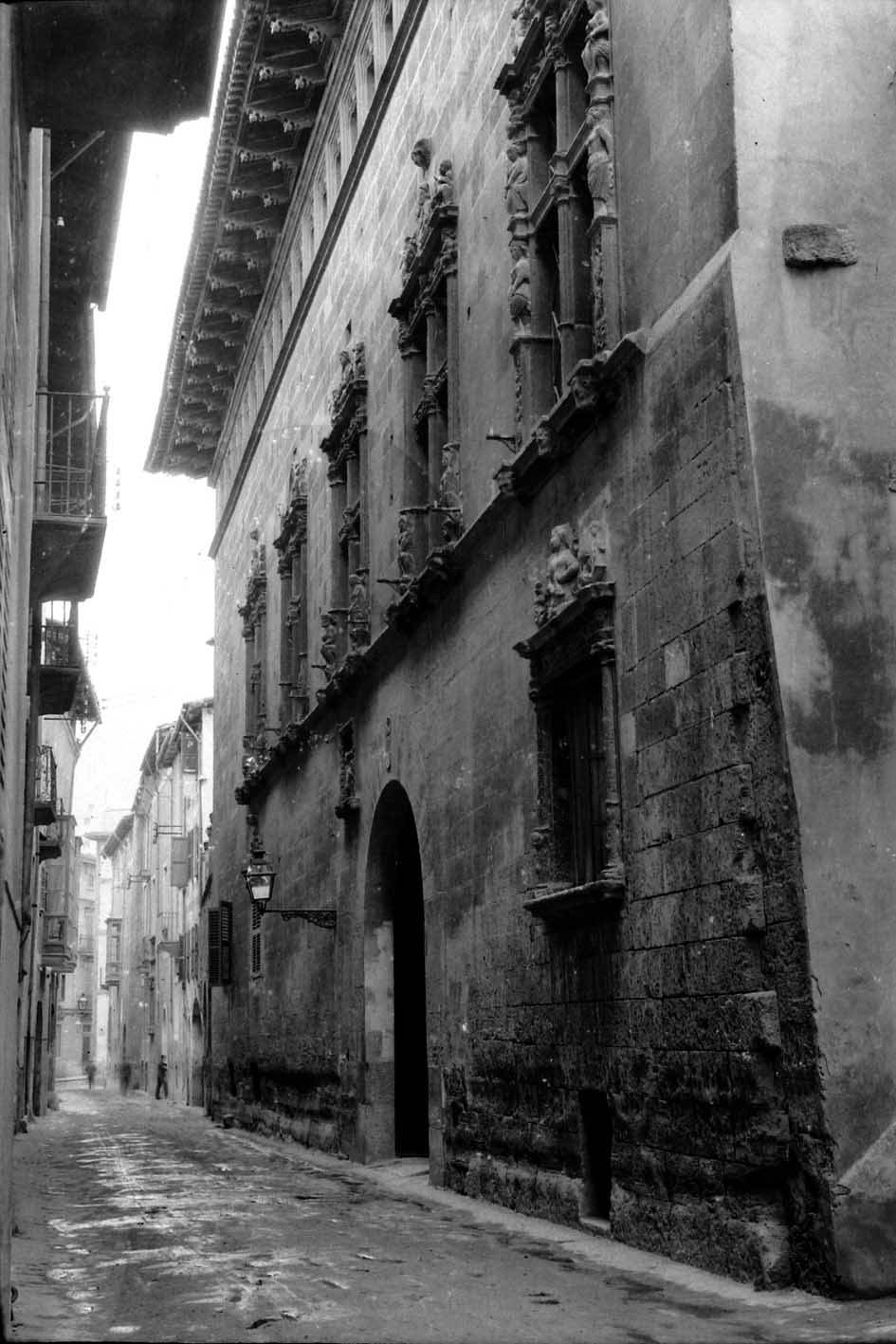
Can Catlar (also known as Can Catlar del Llorer or Cal Marquès del Palmer) is a historic townhouse in Palma de Mallorca's old town, listed as a Spanish cultural asset (Bien de Interés Cultural) since 1973. What is Can Catlar? It's a patrician house with a layered history stretching back to the Middle Ages, with some researchers pointing to even earlier, Muslim-era roots on the site. The building as it stands today combines elements from several periods: Gothic arches and courtyard fragments show 14th-century craftsmanship, while the main structure was reshaped repeatedly, notably in the 16th and 17th centuries. It's a classic example of a Palma noble residence, where successive generations of owners adapted the interiors to their needs while leaving the oldest, most valuable features untouched. The building's name traces back to the Descatlar (Dezcatlar) family, and the site once played an economic role too — from 1442 it housed the Seca, the mint that struck Majorcan currency, established under a grant from King Alfonso V to Pere Abrí-Descatlar y de Santacoloma. In the 18th century, the estate's owner, Pedro Dezcallar y Net, was granted the title of Baron of Pinopar by Archduke Charles of Austria. By the mid-19th century the property passed to the Llorac family, which explains the "del Llorer" variant of the name still used today. What will you see inside? The heart of Can Catlar is its courtyard — one of the oldest and most valuable patios in Palma's entire old town. This is where the building's Gothic origins are most visible: stone arches, proportions typical of medieval Majorcan residential and defensive architecture, and a layout that has survived every later renovation. The building currently houses Palma's Municipal Archive (Arxiu Municipal), which occasionally hosts temporary exhibitions open to visitors — it's worth checking the current schedule before you go, since access to the interior tends to be limited to the archive's opening hours or the run of a specific exhibition. How do you get there? Can Catlar sits right in the heart of Palma's old town, within the dense grid of narrow streets best explored on foot. The easiest route is a short walk from La Seu Cathedral or Plaça de Cort — just a few minutes through the shaded old-town lanes. Since the area is largely pedestrianised, driving there doesn't make sense; leave the car in a car park on the edge of the historic centre and continue on foot. When should you visit? The best time to explore Palma's old town, including the Can Catlar area, is spring (April–June) or early autumn (September–October), when temperatures are milder than in July and August and the streets are less crowded with tourists. If you specifically want to step inside during an archive exhibition, plan your visit for a weekday morning, when Palma's cultural institutions are typically open. Frequently asked questions Is Can Catlar open to visitors? The building now houses Palma's Municipal Archive, so access to the interior depends on the archive's opening hours and any temporary exhibitions — it isn't a standard tourist attraction with fixed visiting hours. Where does the name Can Catlar come from? The name refers to the Descatlar (Dezcatlar) family historically tied to the site, while the "del Llorer" variant refers to the Llorac family, who took over the estate in the 19th century. What's the building's most valuable feature? Architecture historians most often point to the courtyard with its Gothic arches as the oldest and best-preserved part of the structure. Are there similar landmarks nearby? Yes — Palma's old town is known for many similar courtyards and patrician townhouses, which together form a natural walking route through the oldest part of the city.
-
Tower of Mendoza
Mendoza
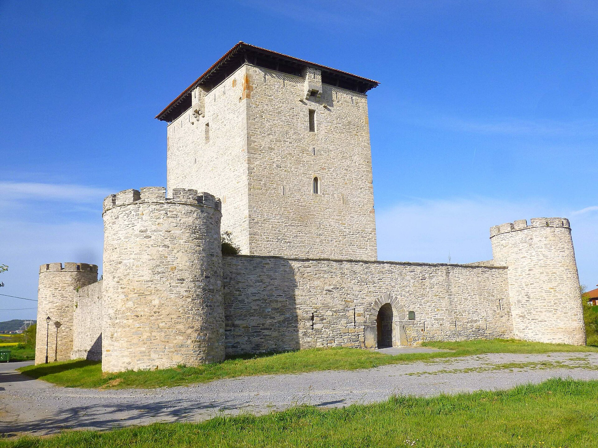
The Tower of Mendoza is a medieval defensive tower standing within the municipality of Vitoria-Gasteiz, capital of the Álava province in the Basque Country, Spain. The tower was declared a Bien de Interés Cultural in 1984, placing it among Spain's most strictly protected heritage sites. Its position is far from arbitrary — it sits strategically between the old roads of Castile and the Ebro river, a location that shaped its defensive role for centuries. What is this place? Towers like this one were built by noble families of Álava during the Middle Ages to protect their estates and keep watch over the trade routes running through the region. The stone structure of the Tower of Mendoza is a typical example of Basque noble architecture from that era — tall, solid, and stripped of decorative flourish, built for defense rather than display. Its location between the Old Castile roads and the Ebro valley was strategic by design: whoever held this point controlled the flow of people and goods between the north and the interior of the Iberian Peninsula. The Bien de Interés Cultural status granted in 1984 means the tower is subject to strict conservation rules — no alterations or renovations can take place without approval from the relevant heritage authorities. It's one of several such towers scattered across Álava, but its proximity to Vitoria-Gasteiz makes it an easy stop for anyone exploring the wider region. How do you get there? The tower lies within the municipality of Vitoria-Gasteiz, so the most convenient way to reach it is from the city center, either by car or local public transport heading toward the outlying areas. Vitoria-Gasteiz has solid rail and bus connections to Bilbao, San Sebastián, and Madrid, making the tower a natural addition to a Basque Country itinerary for anyone already based in the Álava capital. It's worth planning the route in advance and checking current access conditions before visiting — as a legally protected monument, the tower may have limited interior access, with viewing often restricted to the exterior structure. What will you see? The main draw is the tower itself — a massive stone structure that has endured for centuries and still impresses with its raw simplicity and solidity. It's a chance to see firsthand the kind of defensive architecture that once dominated this part of Spain, back when local noble families competed fiercely for territory and influence. The surrounding landscape has its own appeal — sitting between the old trade routes and the Ebro valley, the site offers a pleasant view over the Álava countryside, where farmland meets the remains of medieval defensive infrastructure. When should you visit? Spring and early autumn are the best times to visit, when Basque Country weather is mild and the surrounding land is green. Summer can get quite hot around midday, while winter in this region tends to be cold and rainy, making outdoor sightseeing less comfortable. Frequently asked questions Can you go inside the tower? As a legally protected Bien de Interés Cultural site, interior access may be limited. Check current visitor information before planning a visit. How far is the tower from central Vitoria-Gasteiz? The tower is located within the Vitoria-Gasteiz municipality, so travel time from the city center is relatively short, depending on the exact spot within the municipal area. Is it worth combining with other regional sights? Yes — Vitoria-Gasteiz and the wider Álava province feature several similar defensive towers along with the city's historic center, making this tower a good fit for a broader regional itinerary. Is this a good spot for families with children? Viewing the monument from the outside is simple and safe for all ages, though don't expect extensive on-site tourist facilities.
-
Otazu jauregia
Arratzua-Ubarrundia
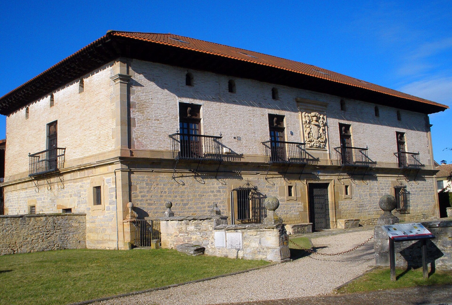
Otazu jauregia is a Baroque manor house standing in the eastern part of the town of Zurbano, in the Otxategi neighborhood, within the municipality of Arratzua-Ubarrundia in the province of Álava, Basque Country. The Basque word "jauregia" simply means "palace" or "manor house" — equivalent to the Spanish "palacio" — and in this region it typically refers to a grand rural noble residence rather than a royal palace. How to get there? Zurbano sits in a quiet, agricultural part of Álava, east of Vitoria-Gasteiz, the provincial capital. A car is the most practical way to reach it, since the surrounding countryside is classic Basque valley terrain dotted with scattered villages and farmsteads. The manor stands in the Otxategi neighborhood, off the main tourist routes, so visitors tend to be people specifically interested in residential architecture and local noble family history rather than mass tourism. What will you see? The building is a fine example of a 17th-century Basque Baroque palace. Before it was built, the site held a defensive tower called Torre de Basterra, owned in the mid-17th century by Juan Ruiz de Trocóniz and his wife Francisca Vélez de Guevara. When her mother died in 1665, their daughter María Ruiz de Trocóniz y Vélez de Guevara inherited the property, and together with her husband, Juan Ruiz de Otazu e Ibáñez de Matauco, she chose to replace the uncomfortable defensive tower with a comfortable, stately residence. This is why the building's façade displays a large coat of arms combining the heraldry of the Otazu and Guevara families. The façade is rich in Baroque detail: wrought-iron balconies, elaborately carved surrounds on the ground-floor doors and windows, and the central coat of arms mentioned above, the building's most recognizable feature. Attached to the main structure is an annex with a gallery supported by segmental "carpanel" arches, characteristic of the regional architecture of the period. The whole is crowned by a broad wooden eave resting on carved corbels, lending a sense of lightness despite the building's massive stone construction. The manor represents the typology of the Basque rural palace — a building combining residential and representative functions, raised by families who had accumulated wealth and social standing but no longer needed the defensive fortifications of earlier centuries. In April 2023, the Arratzua-Ubarrundia town council accepted a bequest from Alfonso de Otazu that included the manor house, earmarked for cultural use, opening the prospect of the building becoming accessible to a wider public in the future. When to visit? Because the property is under private or municipal management and does not operate as a permanent tourist attraction with regular opening hours, it's best treated as part of a longer route through Arratzua-Ubarrundia's civil architecture, combined with nearby manor houses and churches. Spring and early autumn offer the most pleasant weather, when the Basque valleys turn green and temperatures stay moderate, without the heat typical of Spain's Mediterranean summer. Frequently asked questions Is Otazu jauregia open to visitors? The building does not operate as a museum with regular opening hours. Since 2023 it has belonged to the municipality, which plans to use it for cultural purposes — it's worth checking with the town council for current access information before visiting. Where does the manor's name come from? The name comes from the Otazu family — specifically Juan Ruiz de Otazu, who together with his wife built the current structure on the site of the Basterra family's former defensive tower. What does the coat of arms on the façade represent? The central coat of arms combines the heraldry of two families, Otazu and Guevara, commemorating the marriage that led to the construction of the present residence. How is a "jauregia" different from a regular palace? It's the Basque term for a grand rural noble residence — typically smaller than a European royal palace, but locally significant as a status symbol for the family that built it.
-
Pazo de Lanzós
Betanzos
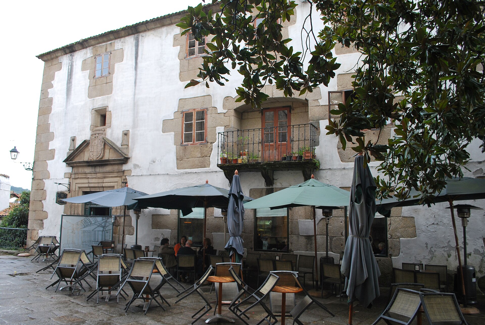
Pazo de Lanzós is a 17th-century Galician manor house standing on Calle Lanzós in Betanzos, directly facing the Church of Santiago. Built between 1620 and 1625, its oldest and most valuable feature is a medieval defensive tower that witnessed some of the most turbulent episodes in Galician history. How do you get there? Betanzos sits in the province of A Coruña, close to the provincial capital and to the route of the Camino Inglés (the English Way) to Santiago de Compostela. The town has good road and bus connections to both A Coruña and Ferrol. Pazo de Lanzós stands right in the heart of the old town, only a few minutes' walk from the main square and the church of Santa María do Azougue, making it an easy stop on a walking tour of the historic centre. What will you see? The façade draws the eye with a projecting balcony resting on three stone corbels, and a straight, rectilinear main doorway crowned by a broken pediment bearing the coat of arms of the first Count of Maceda. That heraldic shield points to the noble lineage of the family who raised the house in the early 17th century. The most fascinating part of the whole ensemble, however, is the tower, known as the Torre de Lanzós. Its origins predate the manor house itself and are tied to the Irmandiño revolts — 15th-century uprisings of Galician peasants and lesser nobility against powerful feudal lords, upheavals that shook the region and led to the destruction of many fortified residences. Originally the tower served a defensive purpose, complete with battlements and arrow slits. Later, mainly during the 18th century, it underwent significant changes: the battlements were replaced by an ordinary roof, the arrow slits were blocked up, and new, larger window openings were cut into the walls, adapting what had once been a stark fortification into a more residential structure. The stonework was also covered with a layer of cement at that time. Today the building operates as a hospitality establishment, so visits are largely limited to admiring the architecture from the outside — the façade, the tower, and the distinctive balcony. Even so, a stroll around the pazo gives a strong sense of the atmosphere of Betanzos' historic centre, a town nicknamed "Ciudad de los Caballeros" (City of Knights) for its rich noble past. When should you visit? Betanzos can be visited year-round, but spring and early autumn are especially pleasant, when Galicia's temperatures are mild and the town sees fewer visitors than in peak summer. It's worth pairing a visit to Pazo de Lanzós with a walk through the rest of the old town's landmarks — its Gothic churches, medieval streets, and the famous Parque do Pasatempo. For those walking the Camino Inglés, Betanzos is a natural stop, and its historic pazos, Lanzós among them, form an important part of the town's character. Frequently Asked Questions Can you visit the inside of Pazo de Lanzós? The building currently functions as a hospitality establishment, so interior access is essentially reserved for guests. Visitors admire the manor mainly from the outside, walking along Calle Lanzós. What is the building's most valuable feature? Without a doubt, the tower known as the Torre de Lanzós, thanks to its connection to the 15th-century Irmandiño revolts — one of the pivotal episodes in Galician history. When was the pazo built? The manor house itself was built between 1620 and 1625, although the tower has older, medieval origins. Is it worth combining with the rest of Betanzos? Yes — Pazo de Lanzós sits right in the historic centre, so it's easy to include on the same walk as the Church of Santiago, the main square, and the town's other landmarks.
-
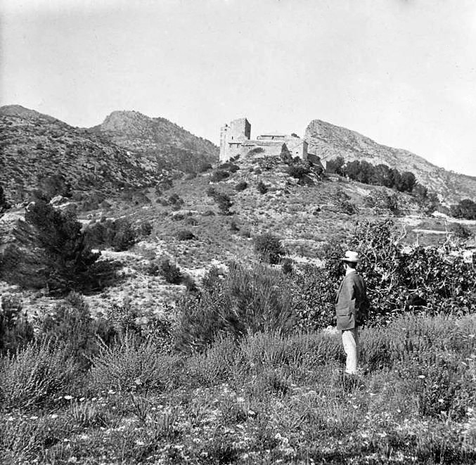
Torre de Sant Elm
Sant Elm
Torre de Sant Elm is a medieval defensive complex overlooking the bay in the village of Sant Elm, part of the municipality of Andratx on Mallorca. Also known locally as Castell de Sant Elm, it combines the unusual history of a seafarers' hospital with that of a coastal watchtower built to fend off pirate raids. Where does this tower come from? The complex was built in 1279 on the orders of James II, King of Mallorca. It began life not as a fortress but as a shelter — a quarantine station for sailors and fishermen, accompanied by a small chapel and a prison for detainees. It wasn't until the mid-16th century, as raids by corsairs sailing from North Africa intensified, that a proper defensive tower was added to protect both the settlement and the people sheltering in the hospital. The tower never worked in isolation. It communicated by smoke signal with other lookout points strung along the coastline, including Torre des Cap Andritxol and Torre de Cala en Basset, together forming an early-warning network against seaborne attacks. By the end of the 16th century the hospital had stopped operating. The chapel remained under church authority, while the tower itself came under the supervision of a local official (the batle). A surviving weapons inventory shows the garrison held an artillery piece weighing several dozen kilograms, a store of gunpowder, and cannonballs — the tower stayed armed and operational until 1867, when it was handed over to the state treasury. What will you see on site? In 1875 the property was bought by Archduke Ludwig Salvator of Austria, a well-known devotee of Mallorca, who carried out his own alterations and additions to the complex. Today the whole site belongs to the Fundació Illes Balears, which has restored the buildings and keeps them in good condition. Visitors can see both the defensive tower itself and the surviving hospital buildings and chapel around it — a rare Mallorcan example of care-giving and military functions combined in a single site. The complex sits directly above the bay of Sant Elm, with views out to the island of La Dragonera. It is listed as a legally protected cultural property. How to get there and when to visit? Sant Elm lies on the western tip of Mallorca, within the municipality of Andratx, and is best reached by car — about 45 minutes from Palma. In summer the village is also served by local buses from Andratx or Palma Nova. The tower stands right along the seafront promenade, just a short walk from the nearest parking area or bus stop. Spring and early autumn are the best times to visit, with milder temperatures than in the height of summer and a quieter coastline. It's worth pairing the visit with a stroll through Sant Elm itself and a boat trip to nearby La Dragonera, visible from the terrace by the tower. Frequently asked questions Is Torre de Sant Elm open to visitors? Yes, the site is open to the public, with visiting hours Wednesday to Sunday, 10:00 a.m. to 5:00 p.m. What makes Torre de Sant Elm different from typical Mallorcan watchtowers? It started out as part of a larger hospital complex, with the defensive tower added only later — an unusual combination compared with towers built purely for military purposes. Who did the tower communicate with in times of danger? Using smoke signals, it linked up with neighboring lookout points such as Torre des Cap Andritxol and Torre de Cala en Basset. Who manages the site today? The complex is run by the Fundació Illes Balears, which is responsible for its upkeep and for keeping it open to visitors.
-
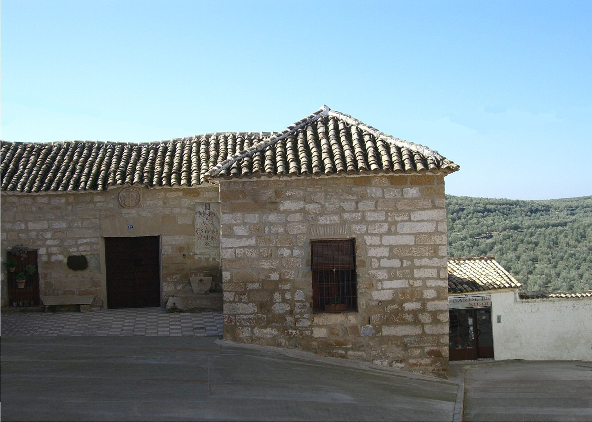
episcopal palace of Begíjar
Begíjar
The Episcopal Palace of Begíjar is a Renaissance residence in the small town of Begíjar, in the province of Jaén, in Andalusia's La Loma y Las Villas region. Built between 1505 and 1510 on the site of an earlier medieval fortress, it is considered one of the earliest examples of Renaissance architecture on the Iberian Peninsula. How did a fortress become a bishop's palace? Begíjar was, for centuries, caught up in disputes over jurisdiction. That dispute was settled in 1477, when the Catholic Monarchs recognized the diocese of Jaén's ownership of the town. From that point, the existing fortress was gradually transformed into a palace — the seat of the bishops of Jaén, who used Begíjar as one of their key strongholds while rebuilding church structures in the province after the period of Arab rule. The bishops kept the palace as one of their principal residences until the 19th century. What will you see there? The palace follows an L-shaped floor plan, with a regular ashlar stone facade. The main doorway is topped by a lintel bearing the heraldic shield of Bishop Fray Benito Marín, a detail that makes the main facade easy to identify. The building sits right in the heart of Begíjar's historic quarter, just a few meters from the Church of Santiago Apóstol and from the 11th-century tower of Begíjar Castle — a structure older than the palace itself, and a reminder of the site's earlier defensive role. It's worth walking around the exterior to take in the stone facade and the coat of arms above the portal, then continuing on to the tower and the church; the three sites form a compact historic ensemble that can be covered on foot in a short visit. Who has stayed here? Over the centuries the palace has hosted a number of notable guests, including King Philip II and the writer Miguel de Cervantes Saavedra. That guest list underscores how significant a stop the bishops' residence in Begíjar was on the map of Jaén province, despite the modest size of the town itself. How to get there and when to visit? Begíjar lies in the province of Jaén, in Andalusia, and is best reached by car — the town sits on the routes connecting Jaén with Úbeda and Baeza, the region's two major Renaissance cities, both listed as UNESCO World Heritage Sites. Pairing a visit to Begíjar with a trip to either city makes sense, since the distances are short. Given the climate of inland Andalusia, spring (March to May) and autumn (September to November) are the most comfortable seasons for walking through the historic center. Summers in the region can get very hot, so it's worth planning any midday sightseeing around that. Protected status The Episcopal Palace of Begíjar was declared a Cultural Heritage Asset (Bien de Interés Cultural) in 1985, and since 2002 it has carried additional protection under the town's municipal planning regulations. That status has helped keep the building in good condition to this day. Frequently asked questions Can you go inside the palace? The building is primarily viewed as a historic monument from the outside — the key features, such as the facade and the coat of arms of Bishop Fray Benito Marín, can be seen from the street in the center of Begíjar. How long does a visit take? The palace, together with the neighboring Church of Santiago Apóstol and the castle tower, can be seen in about 30 to 45 minutes, making it a convenient stop on a route through Jaén province. Is it worth combining with other sights? Yes — Begíjar is close to Úbeda and Baeza, the UNESCO-listed Renaissance cities, so a day trip can easily take in several sites from the same period. Why is the palace historically significant? It marks the moment the local fortress passed into the hands of the bishops of Jaén after 1477, and it stands as one of the earliest examples of Renaissance architecture in Spain — one whose walls hosted guests such as Philip II and Miguel de Cervantes.
-
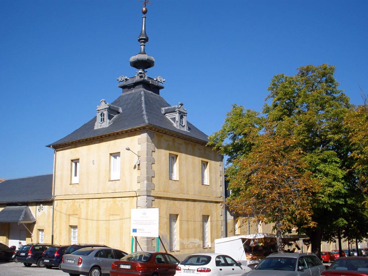
Antiguas Caballerizas Reales, San Ildefonso
Real Sitio de San Ildefonso
Antiguas Caballerizas Reales (the Old Royal Stables) is an 18th-century complex in Real Sitio de San Ildefonso, standing right on the square in front of the La Granja palace in the province of Segovia. Built to house the horses and carriages of the royal court, it still stands out today thanks to its distinctive, decorative architecture. How did the stables come to be? The Royal Site's original stables occupied a building known as La Reglada, in use from the earliest days of the estate. In 1738 the chief equerry, the Count of Montijo, presented King Felipe V and Queen Isabel of Farnese with a plan for a new, much larger stable building. The construction cost was set at 250,000 reales — a figure that shows how central the stables were to a court that relocated to San Ildefonso every summer. In 1773 architect José Díaz Gamones added a further wing facing the street known as Calle de la Guardia, enlarging the whole complex. What is there to see? The building has a rectangular plan around an inner courtyard, and its main block, facing Plaza de Palacio, rises through three levels: ground floor, main floor, and attic. Its most recognizable feature is a set of towers of uneven height — a result of the sloping terrain — each topped with unusual, slate-covered spires unlike anything else in town. Above the main entrance sits a large royal coat of arms modeled in stucco by Santiago Bousseau, one of the facade's most striking details. The whole ensemble reflects the taste of Felipe V's court, where even utilitarian buildings were designed with real visual ambition. Can visitors go inside? The facade underwent restoration work during the 20th century, and in 1945 the building — like several others on the Royal Site — was converted into rental housing. Since then the interior has remained private residential space and is not open to the public. A visit is therefore limited to viewing the building from outside, which is more than enough to appreciate its architecture: the stables remain one of the defining structures around the palace square. How to get there and when to visit? The Antiguas Caballerizas Reales sit right in the center of Real Sitio de San Ildefonso, next to the main square in front of the La Granja palace, so a visit fits naturally into any tour of the palace and its gardens. The town lies a short drive from Segovia, reachable by car or regional bus. Spring and early summer are the best times to come, when the palace garden fountains are running, while early autumn offers fewer crowds and milder temperatures than the height of summer. Frequently asked questions Can you visit the inside of the stables? No — since 1945 the building has served as housing, and the interior is private. Only the facade and courtyard can be seen from outside. Who commissioned the stables? The project was presented in 1738 by the Count of Montijo, chief equerry of the court, to King Felipe V and Queen Isabel of Farnese. What is the most distinctive feature of the building? The uneven-height towers with their original slate spires, and the large stucco royal coat of arms above the main entrance, created by Santiago Bousseau. How much did the building cost to construct? The estimated cost was 250,000 reales, reflecting the scale and importance of the stables within the Royal Site.
-
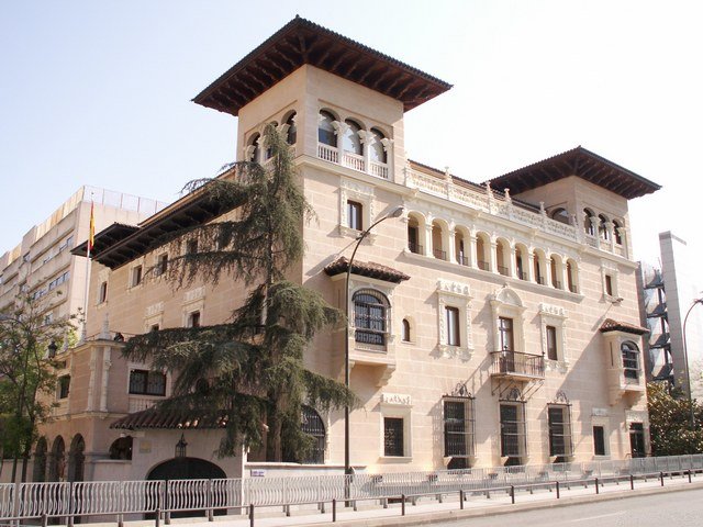
Palacio de Bermejillo
Palacio de Bermejillo is a neo-plateresque palace in Madrid, standing today at Calle de Eduardo Dato 31, on what used to be Paseo del Cisne. It was built between 1913 and 1916 for Marquis Javier Bermejillo del Rey, who purchased the plot in March 1912. Since 1983 the building has housed the Defensor del Pueblo, Spain's national ombudsman office, making it one of the few private aristocratic residences in Madrid that passed into public institutional use while keeping its original architectural character intact. Who built the palace, and in what style? The project was commissioned by Marquis Bermejillo del Rey, but the driving vision came from his wife, Julia Schmidtlein y García-Teruel — the couple met in Mexico, where both their families lived, and married in 1894. The marquise wanted a residence in the Spanish neo-Renaissance tradition. Authorship of the design is still debated among architectural historians: some sources credit architect Eladio Laredo, while others argue the German architect Franz Rank was the actual designer. Whoever held the pen, the result is a building in the neoplateresco style — a movement blending Spanish Renaissance motifs with dense stone ornamentation, fashionable in early 20th-century Madrid as part of a broader nationalist revival in architecture. What should visitors look for in the architecture? The most recognizable feature of the facade is a pair of turrets flanking the building. The stonework is dense with galleries, wrought-iron railings, heraldic motifs typical of the plateresque tradition, and gargoyles. This combination of details sets the palace apart from other Madrid mansions of the period — it isn't an eclectic townhouse but a building conceived as a coherent, monumental composition deliberately referencing Spanish Renaissance architecture. Why does the palace matter culturally? Palacio de Bermejillo stands out among Madrid's palaces because, in the first half of the 20th century, its rooms held some of the most significant private art collections in Spain. The Bermejillo family assembled works that later became a reference point for historians studying art collecting of that era. Because of its architectural and historical value, the building was declared a Bien de Interés Cultural (Asset of Cultural Interest) in 1992 — Spain's highest category of heritage protection. How do you get there, and what should you know before visiting? The palace sits at Calle de Eduardo Dato 31, in the Chamberí district, close to central Madrid — easily reached by metro (Rubén Darío or Alonso Martínez stations) or city bus. Because the building is the active headquarters of a public institution, it isn't a museum with regular tourist opening hours; access to the interior is limited and usually requires advance inquiry or coincides with organized heritage open days or events (such as Madrid Otra Mirada). The facade and exterior architecture, however, can be freely viewed from the street year-round. Frequently asked questions Can visitors go inside the palace? The interior isn't generally open to tourists, since the building serves as the headquarters of the Defensor del Pueblo. Visits are sometimes possible during special Madrid architectural heritage open days. Who designed Palacio de Bermejillo? Authorship is disputed — architect Eladio Laredo is usually credited, though some sources point to the German architect Franz Rank as the true designer. What architectural style is the palace built in? Neoplateresco, combining Spanish Renaissance motifs with rich stone decoration; its distinguishing features are the twin turrets, galleries, and gargoyles on the facade. Why does the palace hold Bien de Interés Cultural status? Because of its architectural value and its history as home to one of Madrid's most important private art collections in the early 20th century; the status was granted in 1992.
-
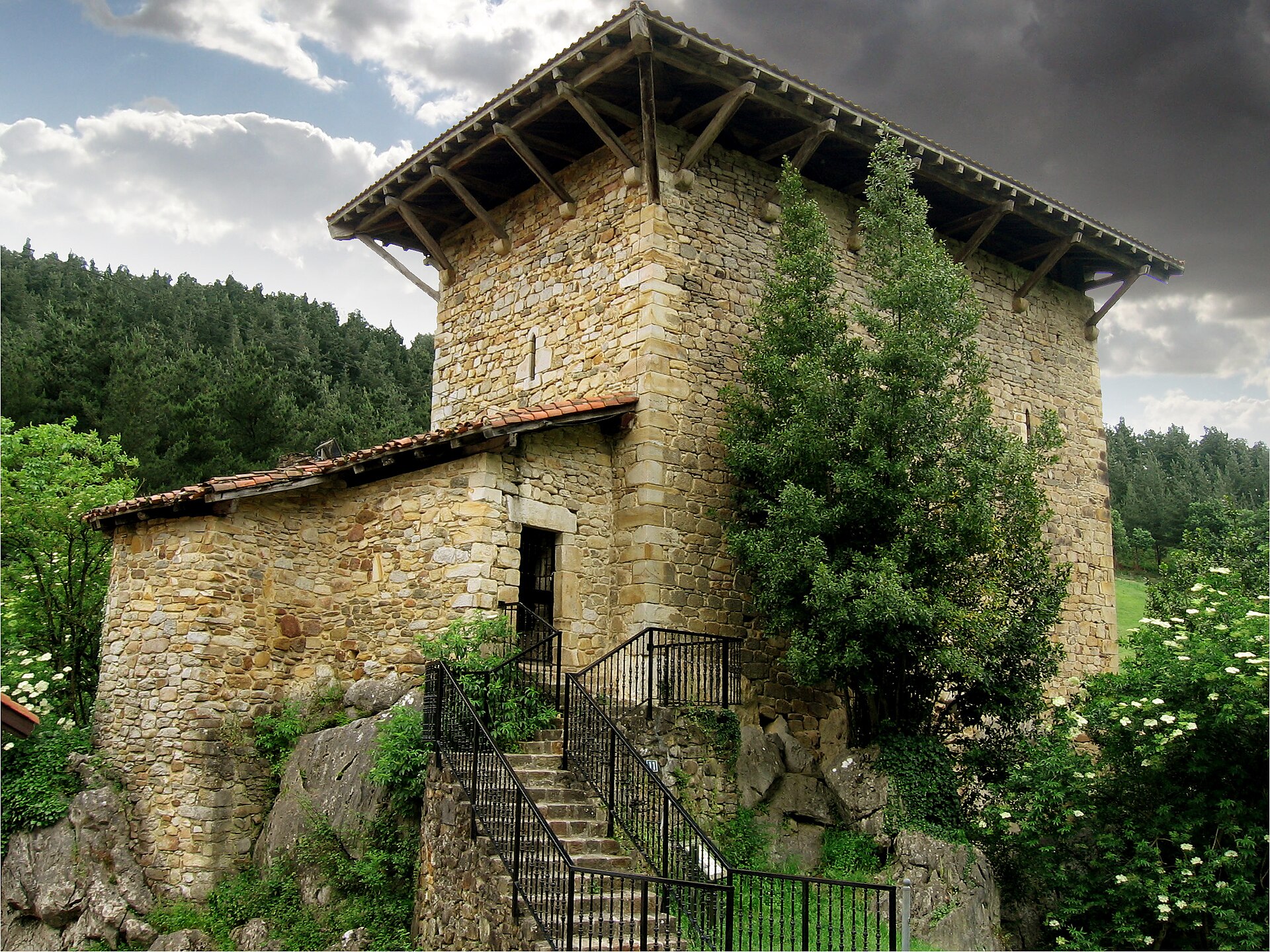
Etxaburu tower
Izurtza
Etxaburu Tower in Izurtza is one of Biscay's best-known Basque tower houses, perched at the foot of Mugarra peak in the Durangaldea region. The building rises directly from a rocky outcrop riddled with natural caves and fissures, a setting that has fed local legend for centuries. The earliest reliable records of the tower date to the 15th century, though the structure standing today is the result of a 16th-century rebuild. Local tradition holds that an earlier version of the tower was torn down on the orders of Henry IV of Castile, and later rebuilt by Sancho López de Ibargüen. Fantastical tales about its origins — some tracing it back to Roman times — still circulate around the site, and together with its dramatic rock-top position they explain why the tower has long drawn visitors to this corner of Biscay. How do you get to Etxaburu Tower? The tower sits roughly a kilometre off the road linking Durango with the Urkiola pass, on the left side of the route running from Mañaria to Izurtza. Driving is the most practical option — it's a short trip from Durango toward Urkiola — but the final stretch has to be covered on foot, along a local track leading up to the base of the rock the tower stands on. Izurtza itself is a small municipality (anteiglesia) in the Basque Country, well connected within Durangaldea, and the tower is often included as a stop on tours through the wider area. What will you see there? Etxaburu has a rectangular floor plan and thick masonry walls, more than a metre wide at the base. The building has two main levels — a lower floor that served as a basement and an upper floor used as living quarters — topped by an additional attic space. What sets it apart is the way it grows out of a hollowed rock cut through with caverns, making it one of the more striking Basque dorretxeak (tower houses) still standing. The building was restored in the 1980s and converted into a youth hostel, a change that helped keep it in good condition to this day. From the slopes of Mugarra around the tower, views open out over the valleys of Durangaldea, and the spot doubles as a starting point for walkers heading up Mugarra or on toward the nearby Urkiola sanctuary. When is the best time to visit? Spring and autumn are the most comfortable seasons, when the mountain paths around Mugarra are easy to walk and temperatures suit a longer excursion. Summer brings more hikers heading toward Urkiola, while winter conditions can make the approach track to the tower harder going. Whatever the season, it's worth setting aside time not just for the building itself but for a short walk around the rock it sits on, since the setting is a large part of the appeal. Frequently asked questions Can you go inside Etxaburu Tower? Since its 1980s restoration the building has operated as a youth hostel, so access to the interior depends on its current use and any booking arrangements — worth checking ahead if seeing the inside is the goal. How far is the tower from the centre of Izurtza? It stands some distance from the village itself, about a kilometre from the main Mañaria–Izurtza road, on the slopes of Mugarra. Is it worth combining the visit with a hike? Yes — the tower lies close to the paths leading up Mugarra and on toward the Urkiola sanctuary, a common extension for visitors who enjoy walking. Where do the tower's name and legends come from? Etxaburu is the name of the local dorretxea, and the stories about its Roman origins and its destruction under Henry IV of Castile belong to the oral tradition of the Durangaldea region — though the confirmed historical record only goes back to the 15th century.
-
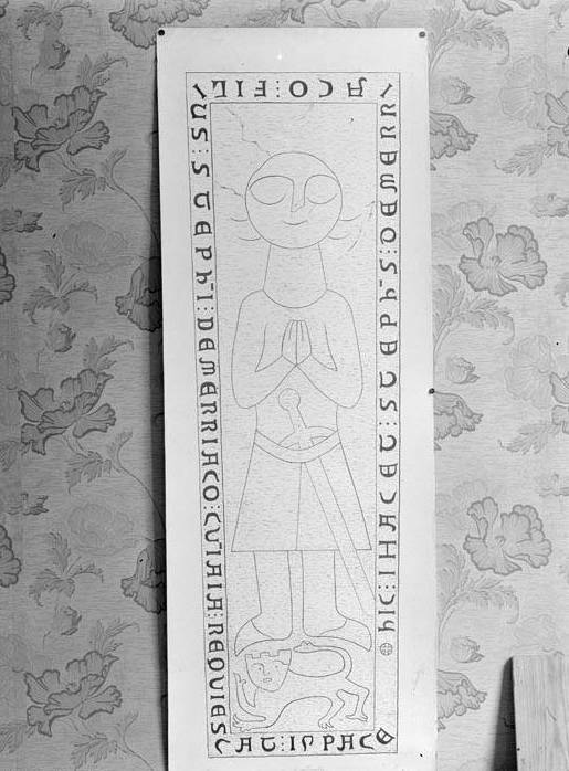
Castell Lleó
Es Bòrdes
Castell Lleó is a medieval castle ruin in the municipality of Es Bòrdes, in Catalonia's Vall d'Aran, standing at the point where the Joèu stream meets the Garona river. Also known by its Aranese name, Castèth Leon, it is listed as a cultural property of national interest. How do you get to Castell Lleó? Es Bòrdes sits in the northern part of Vall d'Aran, a short drive from Vielha, the valley's main town. Reaching the area is easiest by car, following local roads along the Garona river; the whole valley connects to the rest of Catalonia through the Vielha tunnel. The ruins occupy a rise above the village, right at the confluence of the two watercourses — the exact strategic spot that explains why a fortress was built here in the first place. What will you actually see? Little of the original structure survives beyond consolidated ruins, the most recognizable feature being the restored base of a large round tower, topped with a flag representing Vall d'Aran that's visible from a distance. The site's story begins in 1283, when Eustaqui de Beaumarchais, seneschal of Toulouse, raised a defensive tower here following the French king's occupation of the valley. Through the 14th century the tower grew into a full castle-palace, becoming the seat of governors and royal administrators and the main stronghold of the entire valley. In the late 16th century, amid renewed tension with France, King Philip II ordered the border reinforced, and the castle underwent a major rebuild between 1588 and 1594. The fortress was ultimately destroyed in 1719 during the War of the Quadruple Alliance, a conflict that pitted Spain against France, Britain, the Dutch Republic, and Austria. One naming curiosity worth clearing up: despite the resemblance, the castle has no connection to the Spanish region of León — its name instead comes from one of its cannons, cast with a lion's head decoration (Catalan "lleó" means "lion"). When is the best time to visit? Late spring through early autumn (May to October) is the most comfortable window, when trails around Vall d'Aran are dry and temperatures suit a walk up to the ruins. In winter the valley turns into a ski destination (close to the Baqueira-Beret resort), and snow can make the approach to the site harder going. The ruins themselves are accessible year-round, but it's worth checking local conditions before heading out, especially outside summer. Why visit? Beyond the viewpoint over the valley, Castell Lleó is a physical trace of centuries of border history between the Crown of Aragon/Spain and France. The view over the river confluence and the surrounding Pyrenean peaks makes it a rewarding short stop that pairs naturally with a visit to Es Bòrdes itself and the other villages of Vall d'Aran. Frequently asked questions Does Castell Lleó have anything to do with the Spanish region of León? No — it's a coincidence of names. The castle takes its name from one of its cannons, decorated with a lion's head (Catalan "lleó"), not from Castile and León, a region located in an entirely different part of Spain. Is there an entrance fee? No. The ruins sit in the open on a hillside and are freely accessible, with no ticket booth or staff on site. How long does a visit take? Seeing the ruins and viewpoint takes about 30–45 minutes, though it's worth allowing extra time for the walk up from Es Bòrdes and around the surrounding area. Has the castle been rebuilt? Not fully. What remains are consolidated, partly stabilized ruins, including a restored tower base, rather than a reconstructed building.
-
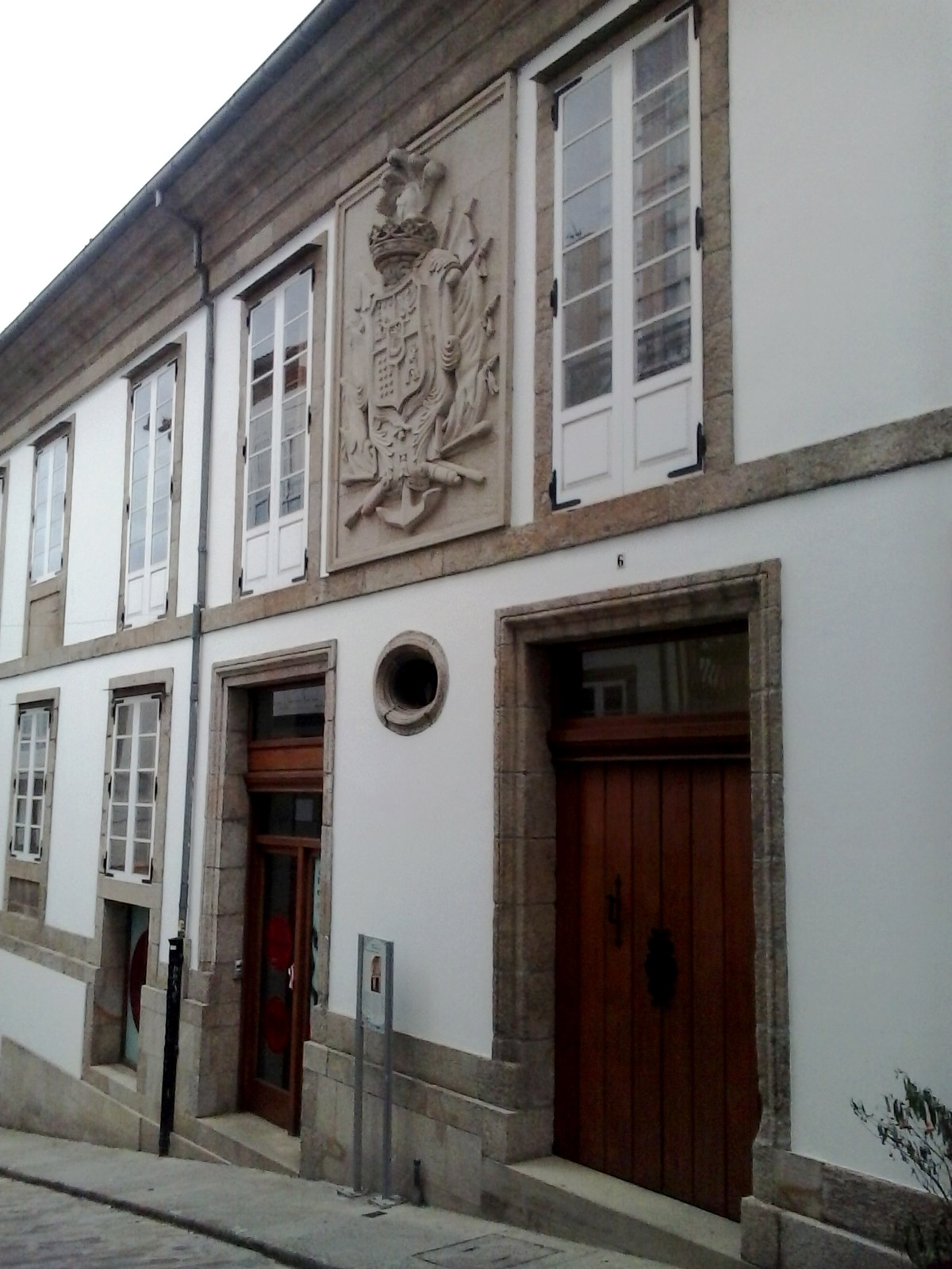
Pazo de Taboada
Betanzos
Pazo de Taboada is one of the most striking urban manor houses in the historic center of Betanzos, a small town in Galicia's A Coruña province. Also known as Pazo dos Condes de Taboada (the Palace of the Counts of Taboada), it stands at Rúa Roldán 6, right in the heart of the old quarter, which has been declared a Historic-Artistic Site. The building went up in 1805 in a restrained Neoclassical style. Its walls are built from rubblework stone, a technique common in Galician construction of the period, and the two-storey facade follows a plain, symmetrical layout. What really draws the eye, though, isn't the architecture but the family coat of arms — a stone shield over two metres tall, mounted directly above the entrance and centred between the building's two doorways. That single detail makes Pazo de Taboada one of the easiest noble houses to spot in town. How do you get to Pazo de Taboada? Betanzos sits about 20 minutes from A Coruña and is well served by regional buses. The pazo is right in the pedestrianised core of the old town, so once you're in Betanzos it's a short walk from the main square or the church of Santiago. The town also lies on the Camino Inglés, one of the historic routes of the Camino de Santiago, so pilgrims heading toward Santiago de Compostela regularly pass right by it. What will you actually see? Pazo de Taboada is privately owned, so visits are limited to viewing the facade from the street — which is enough to appreciate what makes it worth a stop. Look closely at the symmetry of the two entrance doors and the coat of arms set between them: it speaks to the historic standing of the Taboada family in the As Mariñas region. The facade is also a good, compact example of how Galician nobility moved away from the fortified, defensive house designs of the Middle Ages toward more open, decorative urban residences during the 19th century — the same shift is visible in other Betanzos landmarks such as the Casa de la Pescadería. Continue through the old town and you'll find more pazos, coat-of-arms-adorned townhouses, and Gothic churches, together forming one of the best-preserved historic centers in Galicia. When is the best time to visit? Spring and early autumn bring mild weather and noticeably fewer visitors than the summer months. Betanzos also hosts several local festivals worth checking in advance, since the old town — and the streets around the pazo — come alive during those dates. Because the building is only viewed from outside, visiting in the morning or late afternoon, when the light is softer, is the best way to make out the details of the facade and coat of arms. Frequently asked questions Can you go inside Pazo de Taboada? No, it's a private residence. Only the street-facing facade is accessible, but the coat of arms and entrance design are the main draw anyway. How old is the building? It dates from 1805, built in the Neoclassical style that shows through in its simple, symmetrical facade. Why is it called "de Taboada"? The name comes from the Counts of Taboada, whose family coat of arms sits above the entrance — hence the alternative name, Pazo dos Condes de Taboada. Is it worth combining with other sights in Betanzos? Yes. The pazo sits in the historic center, close to other noble houses and churches, making it a natural stop on a walk through the old town.
-
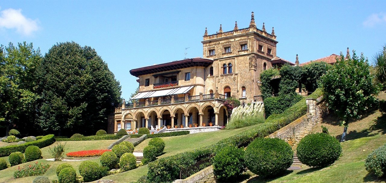
Palacio Lezama-Leguizamón
Getxo
Palacio Lezama-Leguizamón is a striking mansion in Getxo, ranked among the most representative buildings of early 20th-century Biscayan architecture. The palace sits on the Arriluce promontory along Atxekolandeta street, in Neguri, an upscale district of Getxo known for the modernist and eclectic residences built by wealthy families around the turn of the 20th century. It was built in 1902 for the businessman Luis Lezama Leguizamón, designed by architect José María Basterra. The building was later remodeled by Manuel María Smith, one of the most influential architects in the history of the Bilbao area. What will you see? The palace stands out for its almost theatrical silhouette, an effect reinforced by its elevated position on the slope, which lets it dominate the surrounding streets and remain visible from many points across Getxo. From its terraces and windows, the view opens onto the Abra bay, where the Nervión estuary meets the Cantabrian Sea. That combination of drama and setting is one of the reasons it's counted among the most photographed buildings in town. One detail worth knowing: the palace once housed a private library considered among the finest on the Iberian Peninsula, but it was destroyed by a fire in 1933. Nothing of the collection survives today, though the story remains part of the building's lore. Who lives there? Unusually for a tourist landmark, the palace is still owned by the Lezama-Leguizamón family. In the 1960s it was renovated and split into three separate homes, still inhabited by descendants of the family. Because of its architectural value, the building is listed under special protection status, which limits any future alterations. How to get there? The palace is located in Neguri, one of Getxo's seafront districts, a short distance from central Bilbao. The easiest way in is by metro on line L1 to Neguri or Bidezabal station, followed by a short walk through the district's quiet, villa-lined streets. Since it's private property, visits are limited to viewing the facade and grounds from the outside — there's no public entrance. When to visit? Spring and summer are the best seasons for exploring Getxo, when longer daylight hours make it easy to combine a walk through Neguri with a stop at Ereaga or Arrigunaga beach and a crossing of the nearby Bizkaia Bridge. In the afternoon, the light falls favorably on the palace's facade, which architecture photographers tend to appreciate. Frequently asked questions Can you go inside the palace? No — it's private property belonging to the Lezama-Leguizamón family and isn't open to visitors. You can only view it from the outside. Who designed the palace? The original 1902 design was by architect José María Basterra, commissioned by Luis Lezama Leguizamón; it was later remodeled by Manuel María Smith. Why is the palace so distinctive? Its position on the Arriluce promontory and its theatrical architectural style make it dominate the surrounding area, visible from many spots in Getxo — one of the symbols of the Neguri district. How do you get there from Bilbao? The simplest way is by metro (line L1) to Neguri or Bidezabal station, then a short walk through the district's villa-lined streets — just a few minutes on foot.
-
Castro fortress
Vigo
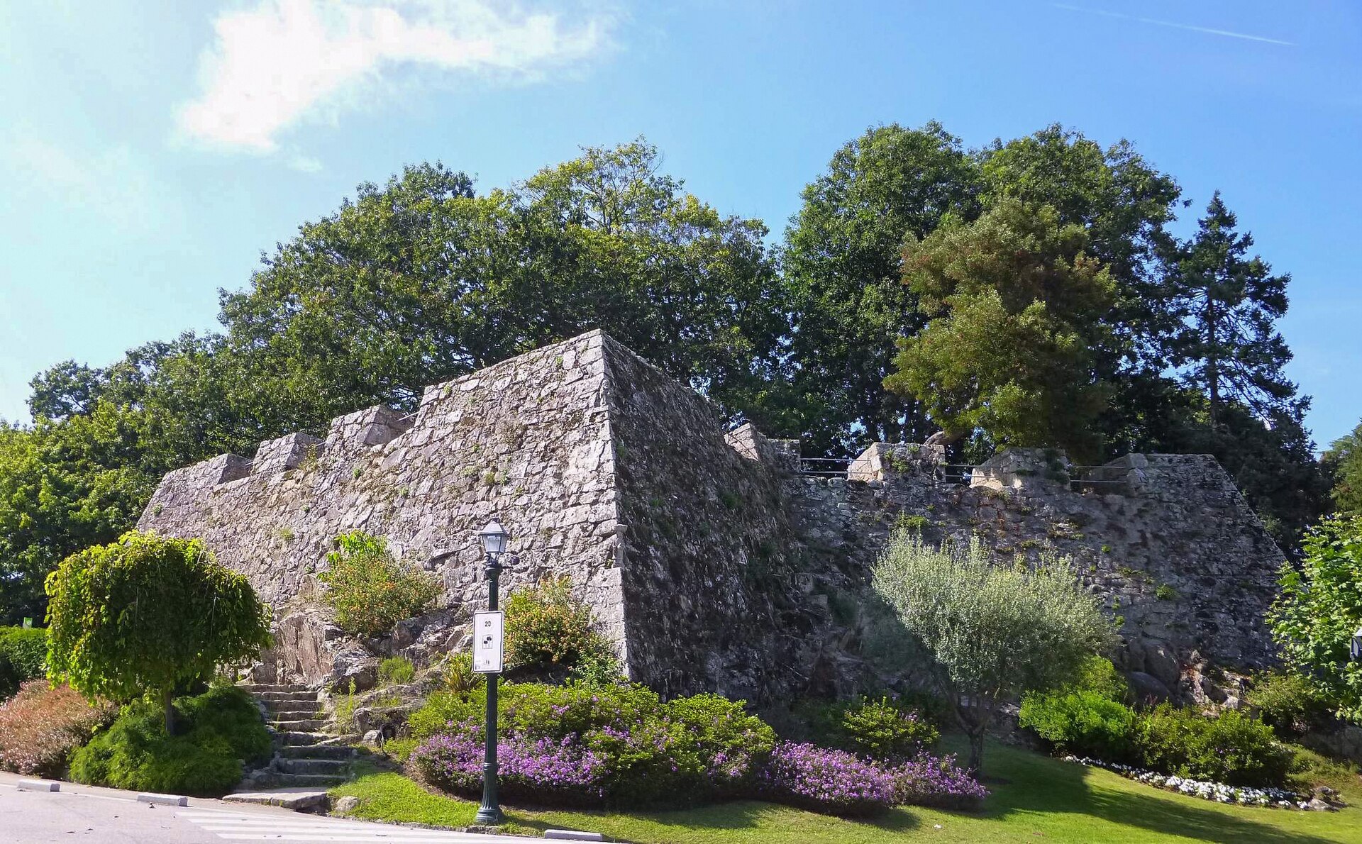
Castro Fortress is a 17th-century stronghold sitting atop Monte do Castro, the hill overlooking the old town of Vigo in Galicia, Spain. It was built in 1665 on the orders of the Spanish crown as part of the coastal defenses during the Portuguese Restoration War, at a time when the region faced the threat of attack from English forces backing Portugal's bid for independence. Today the old ramparts stand within the city itself and form one of Vigo's best-known viewpoints. How do you get to Monte do Castro? The hill rises right above Vigo's historic quarter, so the easiest approach is on foot from the city centre — marked paths and stairways lead up from the harbour area and the Casco Vello district. The climb is moderately steep but short, so no special preparation is needed. Visitors who prefer not to walk the whole way can take a local bus toward the base of the hill and cover the remaining stretch on foot. Comfortable shoes are worth wearing, since the paths inside the fortress grounds and the surrounding park have uneven, partly cobbled surfaces. What will you see there? The centrepiece is the fortress itself — stone defensive walls crowning the hilltop, laid out in the 17th century to guard the bay and harbour against a possible seaborne attack. Walking along the ramparts lets you trace the full perimeter of the old fortifications and see how the builders used the hill's natural shape to strengthen the defensive position. The hill today is landscaped as a public park, so alongside the historic walls you'll find greenery, walking paths, and shaded spots to rest. The real highlight of Monte do Castro, though, is the view. From the fortress walls, a sweeping panorama opens over the Ría de Vigo, the city's commercial and fishing harbour, and the rooftops of the old town spread out below. It's one of the few spots in the city where the historic centre, the waterfront, and the open Atlantic all come into view at once. When is the best time to visit? The fortress and park can be visited year-round, since it's an open-air public space with no fixed schedule. Morning and late afternoon offer the best light for photographs and a quieter walk, especially once the summer heat has eased. In the evening, as the sun sets over the bay, the view over the harbour takes on extra colour, making it a favourite closing stop for locals and visitors ending their day in Vigo. Expect more visitors during the summer peak season, while the hill tends to be considerably quieter outside those months. Why visit Monte do Castro? The site brings together history and one of the best vantage points in Vigo. The fortress is a reminder of a turbulent 17th century for the region, when the conflict between Spain and Portugal shaped life along the Galician coast, while also serving as a natural balcony over the city — no museum ticket or viewing-tower fee required. For anyone exploring Vigo on foot, it's a natural stop that links the old town with a panoramic finish to the walk. Frequently Asked Questions Is there an entrance fee for Monte do Castro? The hill and the former fortress grounds function as a public city park, open to visitors as freely accessible space. How long does a visit take? Walking the ramparts and taking in the views usually takes 30 minutes to an hour, depending on your pace and how many stops you make for photos. Is it worth combining with a visit to the old town? Yes — Monte do Castro sits right next to Casco Vello, so it fits naturally into a walking route through Vigo's historic centre. Is the fortress accessible for children or visitors with limited mobility? The park grounds are generally open to all, but the climb up the hill and the uneven surface of the ramparts can be challenging for strollers or anyone with mobility difficulties.
-
Pazo de Abeledo
Curtis
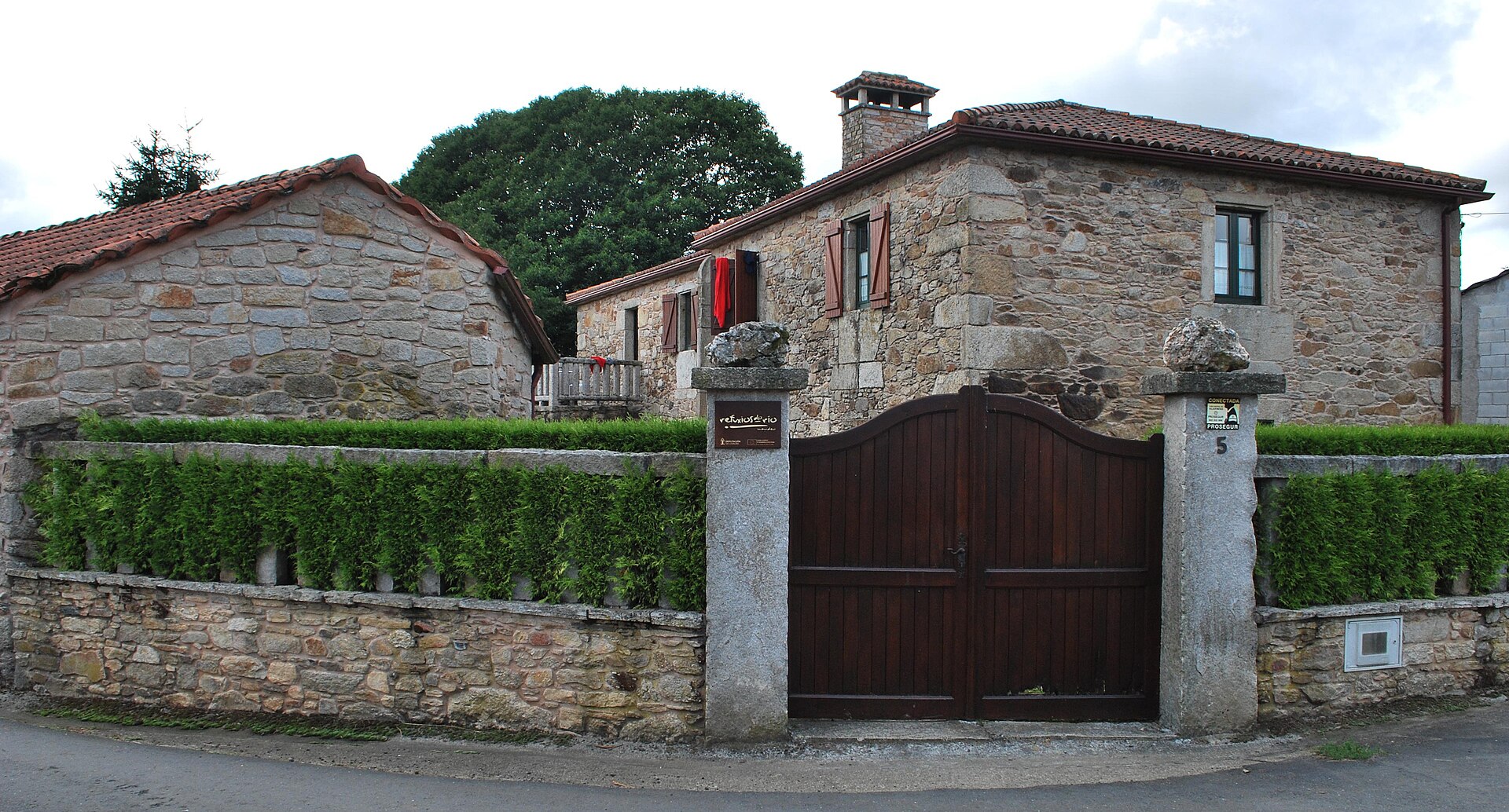
Pazo de Abeledo is a historic manor house in the village of Abeledo, in the parish of Fojado, municipality of Curtis, in the province of A Coruña, Galicia. The building dates from the 19th century and was originally built as a farm; after restoration it now operates as a rural hotel. What is this place? A pazo is the classic Galician form of country estate — a residence combined with farm buildings, all enclosed within a stone wall. Pazo de Abeledo follows that pattern closely: a two-storey main house sits on a walled plot alongside the features typical of rural Galician architecture — a well, a hórreo (a raised traditional granary built on stone or wooden pillars to keep grain dry and away from rodents), and a set of farm outbuildings. The grounds also include a garden and a chapel that has recently been restored. Unlike the grand aristocratic pazos built purely as noble residences, this one has agricultural roots — it started life as a working farm rather than a lordly manor, and that functional, working-farm layout is still visible in how the buildings and grounds are arranged. How do you get there? Abeledo sits within the municipality of Curtis, inland in the province of A Coruña, in eastern Galicia. Curtis is well connected by road, lying on routes that link the A Coruña coast with the interior of the region, making it a convenient stop for travelers moving between Santiago de Compostela and Lugo. Driving is the most practical option — Abeledo itself has no direct rail connection, though the wider area is served by local bus routes. What will you see? A two-storey main house with spacious interior rooms Grounds enclosed by a traditional stone wall A well and a hórreo — the raised granary typical of Galicia Farm outbuildings tied to the estate's original agricultural use A garden next to the main house A recently restored chapel Together these elements give a clear picture of what an upper-tier Galician farming estate looked like in the 19th century, keeping both the working and residential sides of the property intact. When should you visit? Since the pazo now operates as a rural hotel, it can be visited year-round, though the surrounding landscape changes with the seasons. Spring and summer bring the greenest look to the garden and grounds, while autumn and winter carry the damp, cooler climate typical of inland Galicia — worth factoring in if you're planning to explore the wider area on foot. Frequently asked questions What exactly is a pazo? A pazo is a traditional Galician country estate that combines a residence with farm buildings and walled grounds. Pazo de Abeledo has agricultural origins, unlike the more ceremonial pazos built as noble residences. Can you stay overnight at Pazo de Abeledo? Yes — following restoration, the building now operates as a rural hotel, so it's set up for overnight guests rather than being a site you can only view from outside. Where exactly is it located? In the village of Abeledo, parish of Fojado, municipality of Curtis, province of A Coruña, in the Galicia region of northwestern Spain. What else is there to see besides the main building? The hórreo (traditional granary), the well, the farm outbuildings, and a recently restored chapel — together they round out the picture of a Galician rural estate.
-
Castillo de Santiago
Sanlúcar de Barrameda
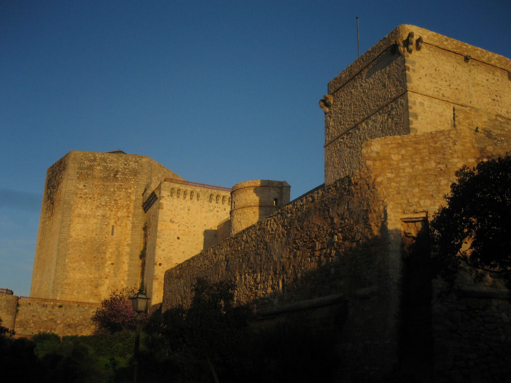
Castillo de Santiago is a medieval fortress standing at the heart of Sanlúcar de Barrameda, in the Spanish province of Cádiz. It was raised between 1477 and 1478 on the orders of Enrique Pérez de Guzmán y Meneses, 2nd Duke of Medina Sidonia and 7th Lord of Sanlúcar — the family whose power controlled the mouth of the Guadalquivir and the trade routes to the Americas for centuries. What does the castle look like? The building follows a late-Gothic style, combining adobe, rubble masonry and cut stone. Its layout is quadrangular, with a barbican and corner towers arranged around a central courtyard that once served as the parade ground for the garrison. This defensive design was typical of the coastal fortifications the Guzmán family built along Andalusia in the second half of the 15th century, when the dynasty was securing control over access to the port. What history is packed into these walls? Over more than five centuries the castle changed function again and again. It served as barracks, hospital and — most persistently — as a prison. During the Peninsular War, following the Battle of Bailén, French soldiers captured by Spanish forces were held within its walls. The 19th and early 20th centuries brought gradual neglect, until the fortress was handed over to the municipality of Sanlúcar in 1932. In 1972 it was declared a historical-artistic monument, granting it formal protection, and a thorough restoration completed in 2003 finally opened it to visitors on a permanent basis. What will you see inside? The entry ticket covers two exhibitions housed within the walls: the Museo del Traje (Costume Museum) and the Museo de las Armas (Museum of Arms). From the ramparts and towers, the view stretches over the old town of Sanlúcar de Barrameda and toward the mouth of the Guadalquivir — the very waterway ships once sailed down on their way to American ports. The inner courtyard, ringed by stone arcades, gives a sense of the scale of the garrison that was stationed here during the Medina Sidonia family's height of power. How do you get there and when should you go? The castle sits on Plaza del Castillo 1, within walking distance of Sanlúcar's historic centre and its riverside promenade. In the winter season (16 September to 15 June) it opens Monday to Saturday from 10:00 to 15:00 and 17:00 to 19:00, and Sundays from 10:00 to 15:00. In summer (16 June to 15 September) it's open daily from 10:00 to 22:00, which makes an evening visit an easy way to avoid the midday heat. It's worth checking the current schedule on the castle's own website before arriving, since opening times shift seasonally. Frequently asked questions Who built Castillo de Santiago? It was built between 1477 and 1478 by Enrique Pérez de Guzmán y Meneses, 2nd Duke of Medina Sidonia, as a fortification guarding Sanlúcar de Barrameda and the mouth of the Guadalquivir. Are there any museums inside? Yes — the entry ticket includes the Museo del Traje and the Museo de las Armas, both located within the castle walls. How long does a visit take, and is it worth climbing the towers? A visit usually takes 45 to 60 minutes. Climbing the towers and ramparts rewards you with views over the old town and the Guadalquivir estuary. Was the castle ever used as a prison? Yes, across different periods it served as a prison, including for French soldiers captured after the Battle of Bailén during the Peninsular War.
-
Pazo de Présaras
Vilasantar
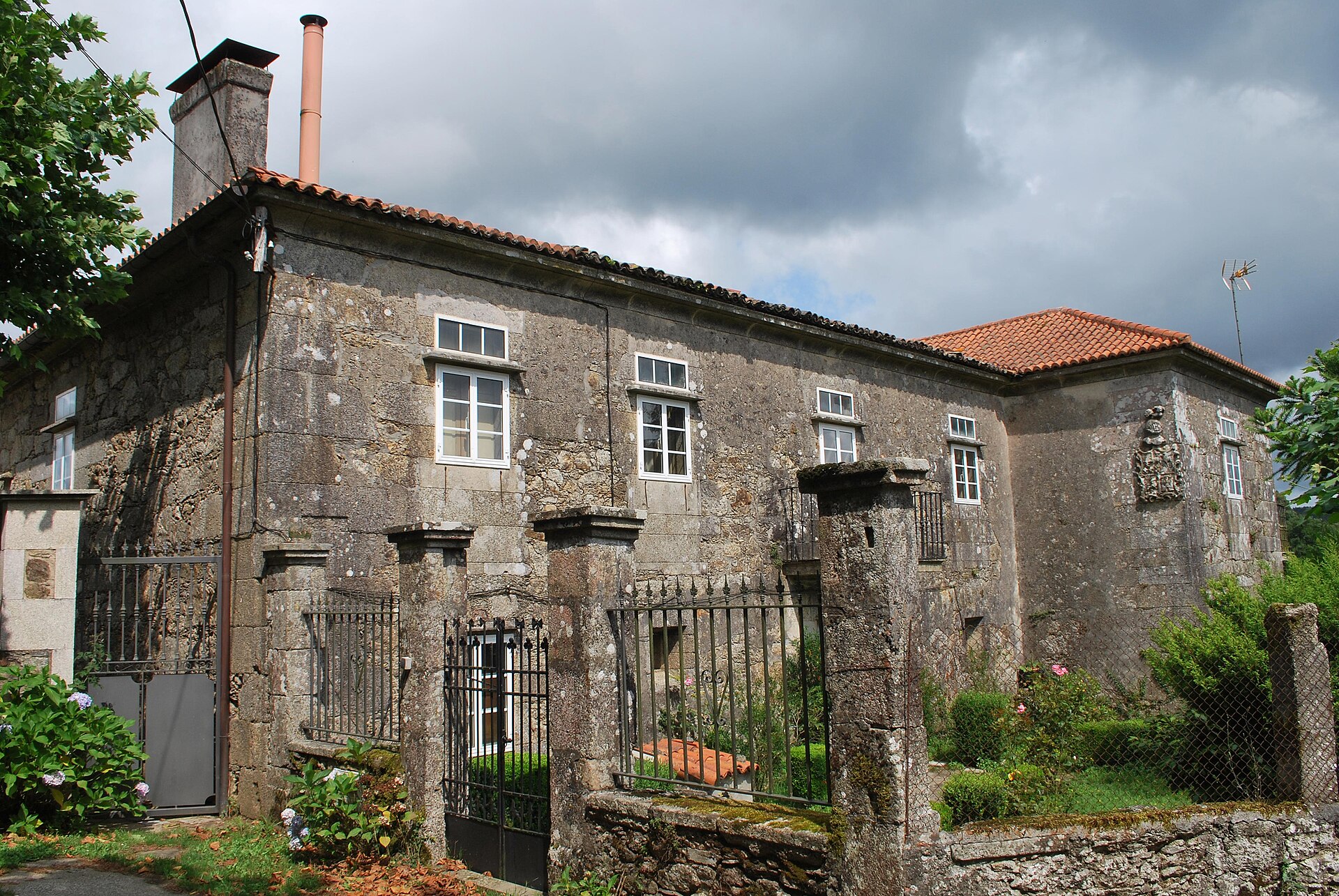
Pazo de Présaras is an 18th-century Galician manor house (pazo) standing in the village of Présaras, in the municipality of Vilasantar, province of A Coruña. It sits directly opposite the parish church of San Pedro de Présaras, and together the two buildings form one of the most distinctive architectural ensembles in this part of inland Galicia. What will you see there? The pazo follows an L-shaped floor plan, a layout typical of Galician manor-house architecture of the period. It was commissioned by Valentín Sánchez de Boado, an "indiano" — a merchant who returned to his home parish after years spent in Peru and reinvested the fortune he had made overseas back into his family's land. The same patron also funded the neighbouring church and commissioned sculptor Xosé Gambino to create its interior decoration, so the two buildings are best visited together as a single historical set piece. Présaras itself lies in the southern part of the Vilasantar municipality, bordering Boimorto, occupying the lowest-lying land in the area and almost entirely encircled by the Cabalar and Tambre rivers. That gives the surroundings a clearly agricultural, valley-bottom character — the pazo is framed by fields and small farmsteads typical of Galicia's rural interior. What is the history behind it? Présaras traces its roots back to the early Middle Ages. As early as the year 920, King Ramiro II of León named Hermenegildo Alóitez Count of Présaras; at that time the county extended over land that today belongs to the neighbouring municipalities of Curtis and Sobrado. That points to the historical importance this now-small corner of Galicia once held as a local seat of power. The pazo standing today, however, dates from much later — the 18th century — an era when many Galician emigrants returning from South and Central America invested their new wealth in building family residences back home. This pattern of "indiano" architecture shaped the built landscape across large parts of Galicia, and the Pazo de Présaras is a clear local example of it. How do you get there? Présaras lies within the municipality of Vilasantar, in the inland part of A Coruña province, in the area known as the Ulla-Tambre-Mandeo region. The village sits along the Camino del Norte, the northern route of the Camino de Santiago, making the pazo an incidental point of interest for pilgrims and travellers following that trail. The most convenient way to reach it is by car, along rural roads that wind through the scenic countryside of inland A Coruña. When should you visit? Spring and early autumn are the best times to come, when the Galician interior is at its greenest and temperatures are mild — ideal both for exploring the surrounding countryside on foot and for taking in the pazo-and-church ensemble at a relaxed pace. Keep in mind that the pazo remains primarily a historic landmark set within a working rural landscape rather than a fully equipped tourist attraction, so it's worth building a visit into a broader route through the Ulla-Tambre-Mandeo region rather than treating it as a standalone stop. Frequently asked questions Who built the Pazo de Présaras? It was built by Valentín Sánchez de Boado, an indiano who returned from Peru and used his overseas fortune to finance both the manor house and the neighbouring parish church. What architectural style does the building represent? It is an example of 18th-century Galician manor-house (pazo) architecture, notable for its L-shaped floor plan. What else is worth seeing nearby? Right next to the pazo stands the parish church of San Pedro de Présaras, whose interior decoration was carved by sculptor Xosé Gambino — the two buildings form a single coherent historical ensemble. Does Présaras have historical significance beyond the pazo itself? Yes — as early as 920 it was the seat of a county granted by King Ramiro II, which in medieval times covered land now belonging to the municipalities of Curtis and Sobrado.
-
Palacio de los Mariscales
Tafalla
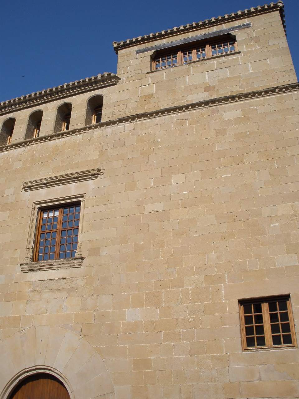
Palacio de los Mariscales stands in the historic centre of Tafalla, a small town in the Navarre region of northern Spain. This 16th-century Renaissance stone building is better known locally as "Casa del Cordón" — the House of the Rope — after a distinctive carved motif framing three of its facade windows. How do you get there? The palace sits on Calle San Juan, in Tafalla's old quarter, an easy walk from the town's main square. Tafalla lies in central Navarre, roughly 38 km south of Pamplona, reachable by road and regional bus services. Drivers usually find it simplest to park near the old town and continue on foot, since the surrounding streets keep their medieval layout and are not always car-friendly. What can you see there? The building's facade, built from solid ashlar stone blocks, is one of the better-preserved examples of noble residential architecture in the area. The carved "rope" detail around the windows gives the house its popular nickname and sets it apart from neighbouring townhouses. After a thorough restoration, the interior now houses a public library, so visitors can step inside and see how the historic rooms were adapted to a modern use. What is the history behind it? The palace was raised in the 16th century as the residence of a noble family. In 1498, Pedro de Navarra, seventh Marshal of the Kingdom of Navarre, moved into the house following his marriage to Mayor de la Cueva, daughter of the Duke of Alburquerque. Their son, Francisco de Navarra, is said to have been born there that same day; he later became prior of Roncesvalles, bishop of Badajoz, and archbishop of Valencia, and took part in the Council of Trent. The family's title — Marshal, or "Mariscal" — is the source of the palace's name. In 1881 the building passed into church ownership and spent roughly a century serving different purposes: a parish house, a Catholic Action centre, and even a cinema and theatre. The Tafalla town council bought it in 1993 and carried out a full renovation. Since 1999 it has operated as the town's public library. When is the best time to visit? Because the building now functions as a library, check its opening hours before planning a visit if you want to see the interior. The facade and its stone details, however, can be admired from the street at any time of year. Tafalla is liveliest during its local festivals and markets, when the old town around Calle San Juan fills with residents and visitors. Frequently asked questions What is the Palacio de los Mariscales? A 16th-century Renaissance palace in Tafalla, popularly called "Casa del Cordón," originally a noble residence and today the town's public library. Why is it called "Casa del Cordón"? Because of the carved rope-like ornament running around three windows on its stone facade. Who lived in the palace? From 1498 it belonged to Pedro de Navarra, seventh Marshal of the Kingdom of Navarre; his son Francisco de Navarra, later archbishop of Valencia, is said to have been born there. What can visitors see inside today? Following its 1990s restoration, the palace now houses Tafalla's public library, open to visitors during its regular hours.
-
Pazo da Mercé
Neda
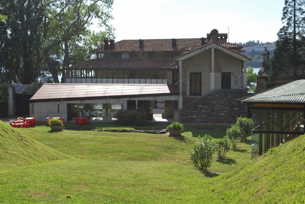
Pazo da Mercé is a historic Galician manor house (pazo) in Neda, in the province of A Coruña, sitting on the edge of the Ría de Ferrol where the Jubia river meets the estuary. Today it operates as a rural tourism house and restaurant, though its story reaches back centuries before it ever welcomed a guest. Where does the building come from? The earliest structures on this plot date to the late 16th century, but the estate's documented history begins in 1700, when a merchant named Francisco Antonio Somalo arrived from Matute, in the Rioja region, to join his brother, the parish priest of Neda. He set up a trading business on the site, right where the old Camino Real met the Jubia river. Industrial pavilions belonging to a tannery known as "La Florida" were built alongside the main residence, and a small baroque chapel dedicated to the Virgen de la Merced (Our Lady of Mercy) went up during the same period — the source of the "Mercé" in the estate's name. How did the pazo change over the centuries? By the 1870s the tannery, like many similar businesses across the region, had fallen into decline and ceased operating. The building then took on a new role, serving for a time as a Franciscan convent. In the 20th century ownership passed to the physician Francisco Cebreiro Barros. The next major turning point came in May 1978, when architect Alfredo Alcalá Navarro carried out a full restoration of the property. In 1991, Pazo da Mercé became the first rural tourism house in the entire province of A Coruña, opening a new chapter for the estate. What will you see on site? The complex combines a former manor residence with remnants of its industrial past and a private chapel, making it an unusual example of a building that once served residential, religious, and commercial purposes all at once. From its terraces and garden, guests look out over the harbour and the waters of the Ría de Ferrol. The grounds include a garden, a seasonal outdoor pool, and a restaurant serving Galician cuisine. Since 2018, the property has also offered electric vehicle charging — an uncommon amenity for a building of this age. How do you get there? Neda sits in the province of A Coruña, roughly 9 km from Ferrol and about 48 km from the city of A Coruña, making the pazo a convenient base for exploring both the coast and the interior. The town also lies along the Camino Inglés, the English route of the Camino de Santiago, so Pazo da Mercé regularly hosts pilgrims looking for a night's rest in historic surroundings. When is the best time to visit? The surrounding area supports outdoor activities for most of the year — fishing, horse riding, diving, and golf are all available nearby, and the hills and paths along the Ría de Ferrol make for good walking routes. Summer is ideal for using the pool and garden, while the quieter off-season months bring out the intimate character of the pazo, with its common areas offering a cosy setting for a longer stay. Frequently asked questions What makes a pazo different from an ordinary hotel? A pazo is a traditional Galician manor house, often built around a chapel and old outbuildings. Pazo da Mercé has kept that historic character even though it now operates as a rural tourism house. Where does the name "da Mercé" come from? From the baroque chapel built on the estate in honour of the Virgen de la Merced (Our Lady of Mercy), constructed during the years when the "La Florida" tannery was still operating on the site. Can you stop here while walking the Camino de Santiago? Yes. Neda lies on the Camino Inglés, so the pazo is a common overnight stop for pilgrims following that route. How far is it to the nearest major cities? Ferrol is about 9 km away, and A Coruña is roughly 48 km away, making it easy to combine a stay here with visits to both cities.
-
Palace of los Condes de Gómara
Soria
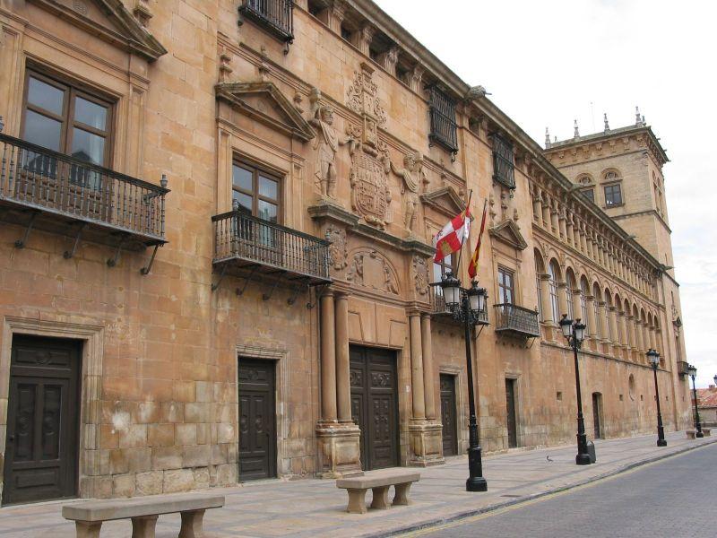
The Palace of los Condes de Gómara is a 16th-century noble residence in Soria, a historic town in the Castile and León region of northern Spain. It belongs to a small group of Renaissance-era city palaces that have survived in Soria, standing as evidence of the wealth accumulated by local noble families during Spain's Golden Age. Where exactly is it located? The palace sits within Soria's historic center, a town on the banks of the Duero river, surrounded by the high, austere plateau landscape typical of this part of Castile. Its coordinates are roughly 41.7647°N, -2.4646°W, placing it right in the middle of the old town, within walking distance of Soria's other heritage sites. How do you get there? Soria isn't served by high-speed rail, so the most practical way to reach it is by car or long-distance bus, with direct connections to Madrid, Zaragoza, and Logroño. Once in town, the palace — like most of Soria's landmarks — sits in the pedestrian-friendly old quarter, so it's best to park near the center and continue on foot. Soria itself is compact enough that crossing the entire historic core rarely takes more than 20–30 minutes. What's the story behind the building? The palace was built in the 16th century as the residence of a family holding the title of Counts of Gómara, one of the noble titles granted in Castile during that period. Buildings of this kind were raised across Spain as a statement of social status: once the Reconquista era gave way to a more consolidated royal power, noble families increasingly invested in grand urban residences that combined a home with a public display of prestige. Today the palace is listed as a cultural property in Soria, confirming its recognized value as a piece of the region's architectural and historical heritage. What will you see on site? Visitors encounter architecture typical of a 16th-century Castilian noble residence — a representative stone facade and the kind of layout common to city palaces of the period, where formal reception spaces were combined with more functional service areas. It's worth pairing a visit to the palace with a walk through the rest of historic Soria, a town known for its Romanesque churches, remnants of its old defensive walls, and atmospheric old-town streets that together paint a coherent picture of a medieval-to-Renaissance Castilian city. When is the best time to visit? The most comfortable conditions for exploring Soria and its monuments fall in spring (April to June) and early autumn (September to October), when temperatures are mild and the region hasn't yet entered its harsh Castilian winter. Summer days can get hot, while winter here is notably cold by Spanish standards — Soria is one of the country's chillier towns, which is worth factoring in if you're planning a trip outside the summer months. Frequently asked questions Can you visit the inside of the palace? Access to the interior depends on the building's current use and any visiting arrangements in place — it's worth checking current details locally or with Soria's tourist information office before your visit. How long does it take to see the palace? Viewing the exterior takes only a few minutes, but it's worth allowing extra time for a longer walk through Soria's historic center to see the palace in context alongside the town's other buildings. Is there an entrance fee? Access conditions depend on the building's current status and function — it's best to confirm this locally, since buildings of this type are sometimes open only partially or on an occasional basis. What else is worth seeing in Soria nearby? The surrounding historic center holds other landmarks, including Romanesque churches and remains of the old city walls — Soria is best explored on foot, linking several sights together into a single walking route.
-
Castell de Granera
Granera
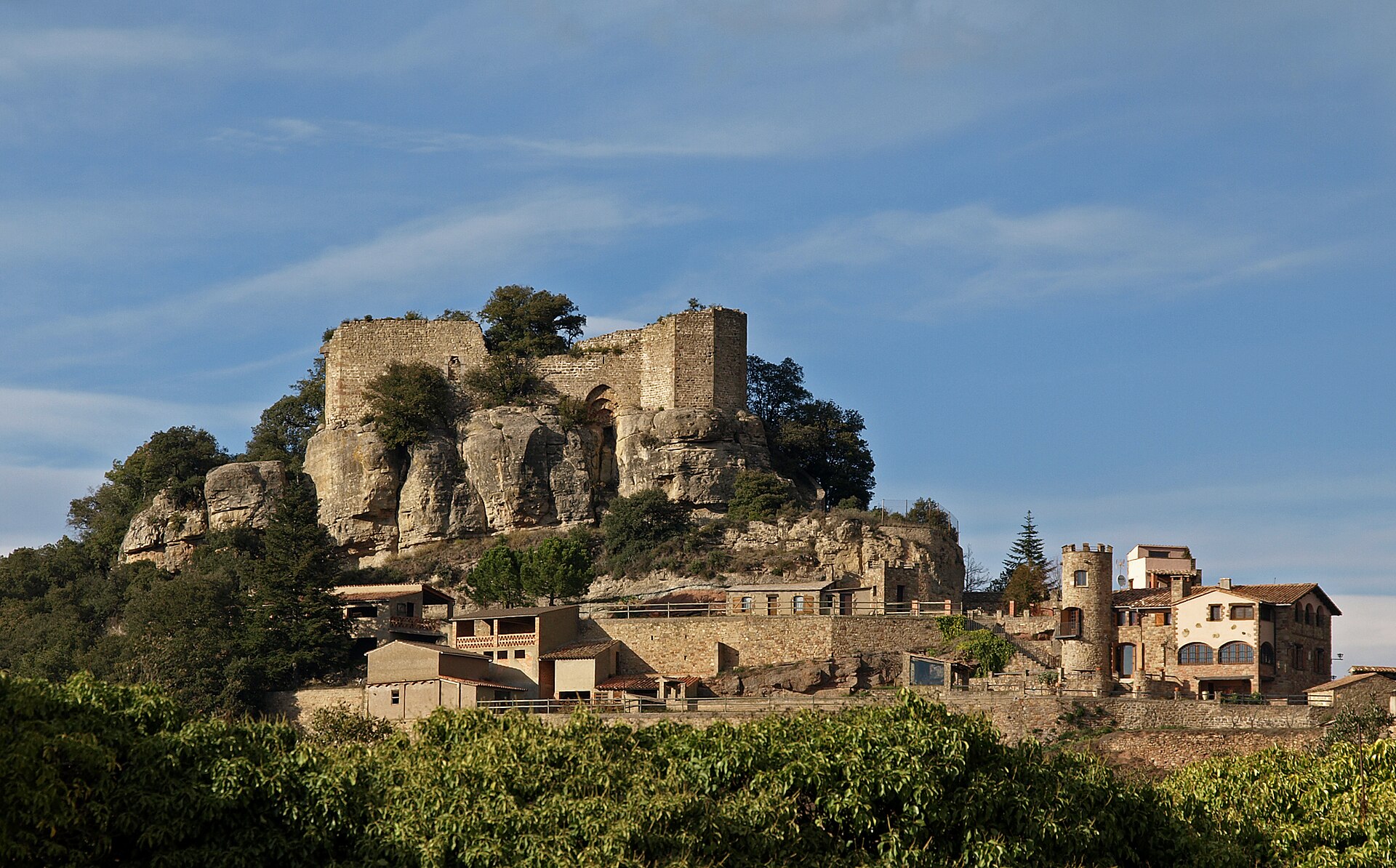
Castell de Granera is a medieval castle guarding the small village of Granera, built on a rocky spur at 824 metres above sea level, right at the edge of the Moianès plateau in the Vallès Oriental region of Catalonia. How do you get there? Granera sits deep in Catalonia's rural hinterland, well off the main tourist routes - which is part of its charm for travellers looking for a quiet, uncrowded stop. The easiest approach is by car along local roads from Moià or Sant Feliu de Codines, followed by a short uphill walk to the castle hill itself. The ruins tower over the village, so the silhouette of the walls is already visible from the centre of Granera, making it a natural landmark to orient any exploration of the surrounding area. What's the history behind the castle? The name Granera first appears in written records in 958, in the oldest surviving documents of the monastery of Sant Benet de Bages. The stronghold itself, recorded in Latin as "castrum de Granaria," is first mentioned in 971. From that point on it functioned as part of the county of Manresa, forming part of the defensive network that protected this frontier region during the early Middle Ages. Over the following centuries, ownership passed through several hands. The castle belonged to the Planella family, who also held the nearby castles of Clarà, Castellnou de la Plana, and Castellcir, and who were related by marriage to the Planella lines of Talamanca and Calders. By the late 16th century the estate had passed to the Despalau family. A turning point came in 1642, when Maria de Despalau sold the castle and its jurisdiction to Jacint Sala i Cervera, who was named Baron of Granera the following year by King Felipe IV of Castile. What does the architecture look like? Most of the surviving stonework dates from the 11th century, though art historians point to earlier fragments typical of the so-called "castell roquer" style, which used the natural rock formation itself as part of the defensive design. The fairly uniform structure visible today is largely the result of a 14th-century rebuild that incorporated older Romanesque elements into the new construction - still visible on the northeastern side of the hill. This layered building history is what makes Castell de Granera a rewarding stop for anyone interested in medieval defensive architecture. What happened to the castle in modern times? In the 1970s, the Barcelona Provincial Council (Diputació de Barcelona) carried out a cleaning and consolidation campaign at the site, overseen by Camil Pallàs, and the ruins were enclosed to protect them from further deterioration. In 1994 the site suffered a fire, after which further consolidation work was carried out on the surviving walls. The castle now holds protected cultural heritage status. When is the best time to visit? Given its altitude and exposed, rocky setting, spring and autumn are the best seasons to visit, offering comfortable conditions for the uphill approach and clear views over the surrounding hills of Moianès and Vallès Oriental from the ramparts. In summer, an early-morning visit is recommended to avoid the midday heat. Frequently asked questions Can you visit Castell de Granera? Yes - the castle is a ruin with protected heritage status, open to view from outside and within the perimeter walls, though it has no staff on site or fixed opening hours. How old is the castle? The earliest mentions of the stronghold date back to 971, while the surviving structure is mostly the product of 11th- and 14th-century construction phases. How high up is the castle located? The castle hill stands at 824 metres above sea level, right on the edge of the Moianès plateau. What else is worth seeing near Granera? It's worth combining the visit with a short walk through the village of Granera itself and the surrounding hills of Vallès Oriental, which offer views over the neighbouring valleys and mountain ranges of the region.
-
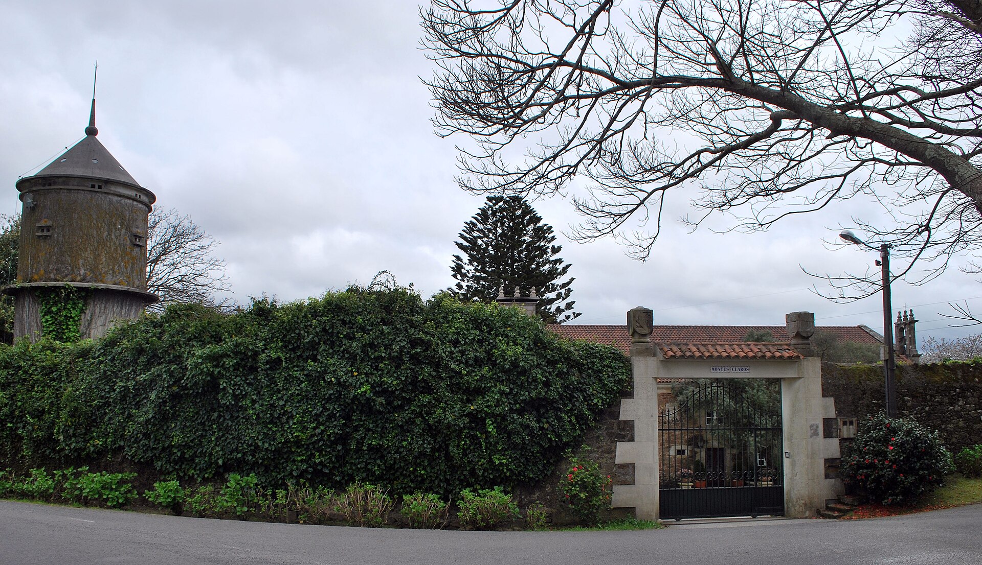
Pazo de Montes Claros
A Laracha
Pazo de Montes Claros is a 17th-century Galician manor house set in the Anllóns river valley, in the hamlet of Montes Claros within the parish of Vilaño, in the municipality of A Laracha (province of A Coruña). It is one of the pazos that has survived the centuries largely intact and still serves today as a working venue for gatherings and celebrations. What exactly is a pazo? A pazo is Galicia's classic form of rural manor estate — a residence combined with outbuildings and a private chapel, all enclosed within a stone wall separating the property from the surrounding land. Pazo de Montes Claros follows this pattern almost textbook-perfectly: the grounds include a two-storey rectangular dwelling, a chapel, a hórreo (the traditional raised Galician granary), a dovecote, and a covered utility area. A cruceiro — a stone wayside cross typical of the Galician countryside — stands just in front of the main building. How do you get there? The pazo sits roughly 20 minutes by car from A Coruña, making it an easy day-trip destination from the city. A Laracha lies along the main roads connecting the coast to the interior of the province, so driving is the most practical way to arrive; private parking is available on site. What will you see inside? The main building's interiors are well preserved and still hold period furniture, giving visitors a genuine sense of what a Galician noble residence once looked like. The chapel on the grounds is dedicated to the Virgin of Sorrows and remains in active use, particularly for weddings held at the property. Outside, look out for the hórreo and the dovecote — both are classic features of traditional Galician rural estates, and finding them this well preserved together in one place is increasingly rare. What is the pazo used for today? Pazo de Montes Claros now operates as a venue for celebrations — weddings above all — and doubles as a restaurant. Guests have access to a terrace, a landscaped garden area, a marquee for larger events, and on-site parking. The combination of historic architecture with practical event facilities has made it a popular choice for couples marrying in the A Coruña area. What else is worth seeing nearby? Close by runs the Ruta da muiñeira, a walking trail that follows the Acheiro river, a tributary of the Anllóns, starting and ending at the Museo dos Muíños de Golmar (the Golmar Mills Museum). It's a good complement to a pazo visit for anyone who wants to learn about the region's traditional water-mill heritage while walking through a landscape typical of rural Galicia. A Laracha sits at the heart of the Anllóns valley, an area known for its concentration of pazos and rural architectural heritage, so a stop at Montes Claros fits naturally into a broader route around the estates and footpaths of the region. Frequently asked questions Can Pazo de Montes Claros be visited as a regular tourist, or only for weddings? The property functions primarily as a wedding and event venue and restaurant, so casual visits depend on current availability and whatever event is taking place — it's worth checking or asking directly before planning a visit. How long does it take to get there from A Coruña? About 20 minutes by car, which makes it an easy addition to a day trip around the province. When was the building constructed? The pazo dates from the 17th century and has retained its original layout and much of its period interior furnishing ever since. What else can you see in the area? Nearby, the Ruta da muiñeira follows the Acheiro river to the Museo dos Muíños de Golmar, where you can learn about the region's traditional water mills.
-
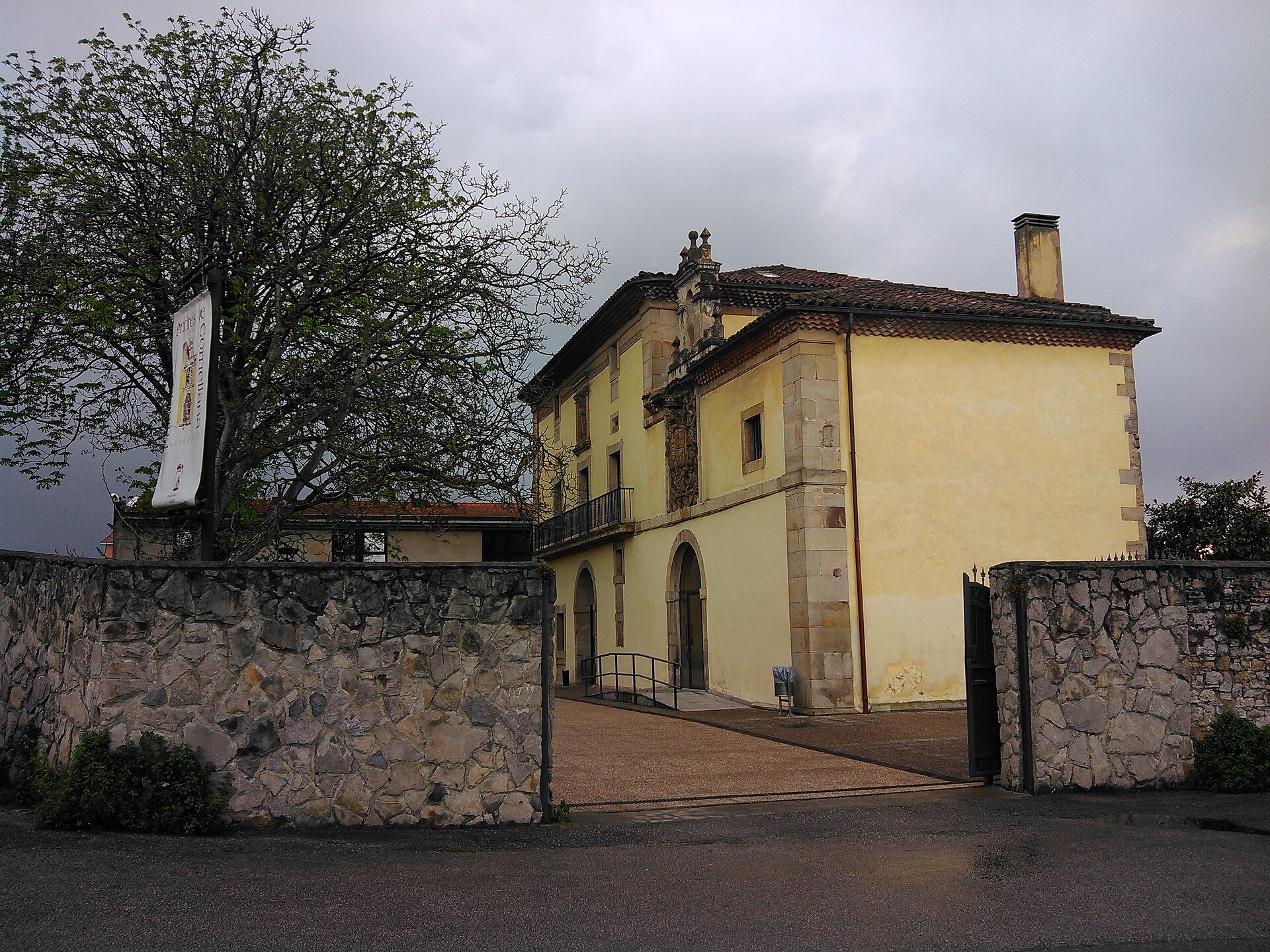
Palacio de San Andrés de Cornellana
Gijón/Xixón
Palacio de San Andrés de Cornellana is an 18th-century noble residence in the Contrueces neighborhood of Gijón/Xixón, Asturias. Despite its name pointing to the village of Cornellana (in the municipality of Salas, some 40 km inland), the building itself has always stood in Gijón — it borrows its name from the title once held by its owners, the Menéndez Valdés family, "lords of Cornellana." Today the palace houses a youth hostel, making it one of the few historic buildings in the region you can actually spend the night in rather than just admire from outside. Why does a Gijón building carry a name from Salas? Since the Middle Ages, the Menéndez Valdés family held the title of lords of Cornellana, an estate that lies today in the municipality of Salas, close to the well-known San Salvador de Cornellana monastery. When the family built their residence in Gijón, they carried their hereditary title over to it, even though the building has no geographic link to Cornellana itself. This is a common pattern in Asturian heraldry — names follow noble titles, not physical location. How do you get there? The palace stands on Camino de los Caleros in the Contrueces neighborhood, a few kilometers from downtown Gijón, next to the church of Nuestra Señora de Contrueces and the former Casa de Novenas. From the city center you can reach it by local bus or a short drive of around fifteen minutes. The surrounding area is a residential district, so it's best treated as a short side trip while exploring Gijón rather than a standalone destination. What will you actually see? The current building dates from 1702, though the site's history goes back much further. The original palace was destroyed in 1382 by the troops of Alfonso Enríquez, count of Gijón and Noreña, during regional power struggles, and was rebuilt in 1412 by Juan Menéndez Valdés. The structure standing today is a later, 18th-century version of the residence. Attached to the palace is a chapel dedicated to San Fernando, built in 1759. Above its door survives a stone coat of arms combining five family shields: the Valdés arms in the center, Espriella in the upper right, Cornellana in the upper left, Jove in the lower right, and the Bernaldo de Quirós arms alongside them. It's one of the more interesting examples of noble heraldry in Gijón, worth a close look if you stop in front of the entrance. Why is it a youth hostel today? In 1978, Gijón's city council bought the palace from private owners for thirty million pesetas, saving the building from further deterioration. Rather than turning it into a museum, the city gave it a new function: in 1992 it opened as the Albergue Juvenil Palacio de San Andrés de Cornellana, a youth hostel that still operates today. This reflects a common approach to heritage protection in Asturias — instead of freezing a palace as an empty monument, authorities give it a daily use that keeps the building alive and lets visitors sleep under a historic roof for relatively little money. When should you visit? Since this is a working hostel rather than a museum with set visiting hours, the best approach is to fold a visit into a longer stay in Gijón, ideally outside the peak summer season when beds are easier to book. The building's exterior and the chapel can be viewed from outside year-round, and a walk through Contrueces pairs naturally with a stop at the nearby church of Nuestra Señora de Contrueces. Frequently asked questions Is the palace actually located in Cornellana? No — despite the name, the building stands in the Contrueces neighborhood of Gijón. The name comes from the Menéndez Valdés family's title as lords of Cornellana, a village in the Salas municipality, not from the palace's actual location. Can you visit the inside of the palace? The building functions as an active youth hostel, so interior access is mainly for guests staying overnight. The facade and chapel can be viewed from outside at any time. How old is the current building? The structure standing today dates from 1702, though the site's history stretches back to the 14th century — the original palace was destroyed in 1382 and rebuilt in 1412. What else is worth seeing nearby? The attached San Fernando chapel from 1759, with its five-part heraldic shield above the entrance, and the neighboring church of Nuestra Señora de Contrueces.
-
Avellaneda Assembly House
Zalla
Avellaneda Assembly House stands right on the boundary between Zalla and neighbouring Sopuerta, in the heart of the Basque Encartaciones region (Bizkaia). For centuries it hosted the general assemblies of the surrounding villages, and today it houses the Museum of Encartaciones, ranking among the province's most significant historic landmarks. How do you get there? The building sits in the Kadagua river valley, about a dozen kilometres from Bilbao, right at the administrative border between Zalla and Sopuerta. It makes a natural stop while touring Encartaciones, a region known for its green valleys and historic small towns. Driving from Bilbao takes roughly 20–25 minutes, and the surrounding area is also well suited to a longer walk linking several nearby villages. What will you see? The earliest record of a building on this site dates back to 1535, when a prison stood here. Construction of the actual assembly house began in 1592 and was completed in 1635, the year the coat of arms was placed on the facade. Over time the site grew into a whole complex of buildings from different periods — mainly the 17th and 18th centuries — including the residence of the corregidor's lieutenant (1597, rebuilt in 1750) and an inn where assembly members stayed overnight (1771). The suppression of the Juntas of Encartaciones in 1806, when a royal decree required the surrounding villages to attend the Juntas of Gernika instead, ended the building's administrative role and left it abandoned for decades. Restoration only began in 1901, commissioned by the Provincial Council of Bizkaia; architect Antonio de Carvelaris aimed to recover the facade's original Renaissance appearance. Another key chapter came in 1932, when architect Diego de Basterra carried out renovations that included building a local school and adapting part of the complex into a small history museum — opened in 1933 as the Museum of Encartaciones, still operating today. The tower that now defines the building's silhouette was added during works carried out between 1942 and 1953. A final, comprehensive restoration followed in 1989. The site also holds a place in the 20th-century history of Basque regionalism: on 9 August 1931, days after an assembly in Portugalete, representatives of the Encartaciones villages met in nearby Sopuerta to draft the basis for a demand for regional autonomy from Spain's Second Republic. When should you visit? Since the main draw is the museum interior, plan your visit around its opening hours, on a weekday or a weekend outside the height of summer heat — Encartaciones can get quite warm in July and August, while spring and autumn are pleasant for walking the surrounding valleys too. Pairing the visit with a stop in nearby Sopuerta, which shares the administrative border with the building, is an easy way to round out the trip. Frequently asked questions What is the Avellaneda Assembly House? It's a historic assembly house where representatives of the Encartaciones villages met from the 16th century onward. It now houses the Museum of Encartaciones. Where exactly is it located? On the border between Zalla and Sopuerta, in the Kadagua river valley, in the province of Bizkaia, about a dozen kilometres from Bilbao. When was the current building constructed? Work on the assembly house began in 1592 and finished in 1635, though earlier structures on the site date back to 1535. Can you visit the interior? Yes — the building houses the Museum of Encartaciones, which presents the history of the region and of the Juntas themselves.
-
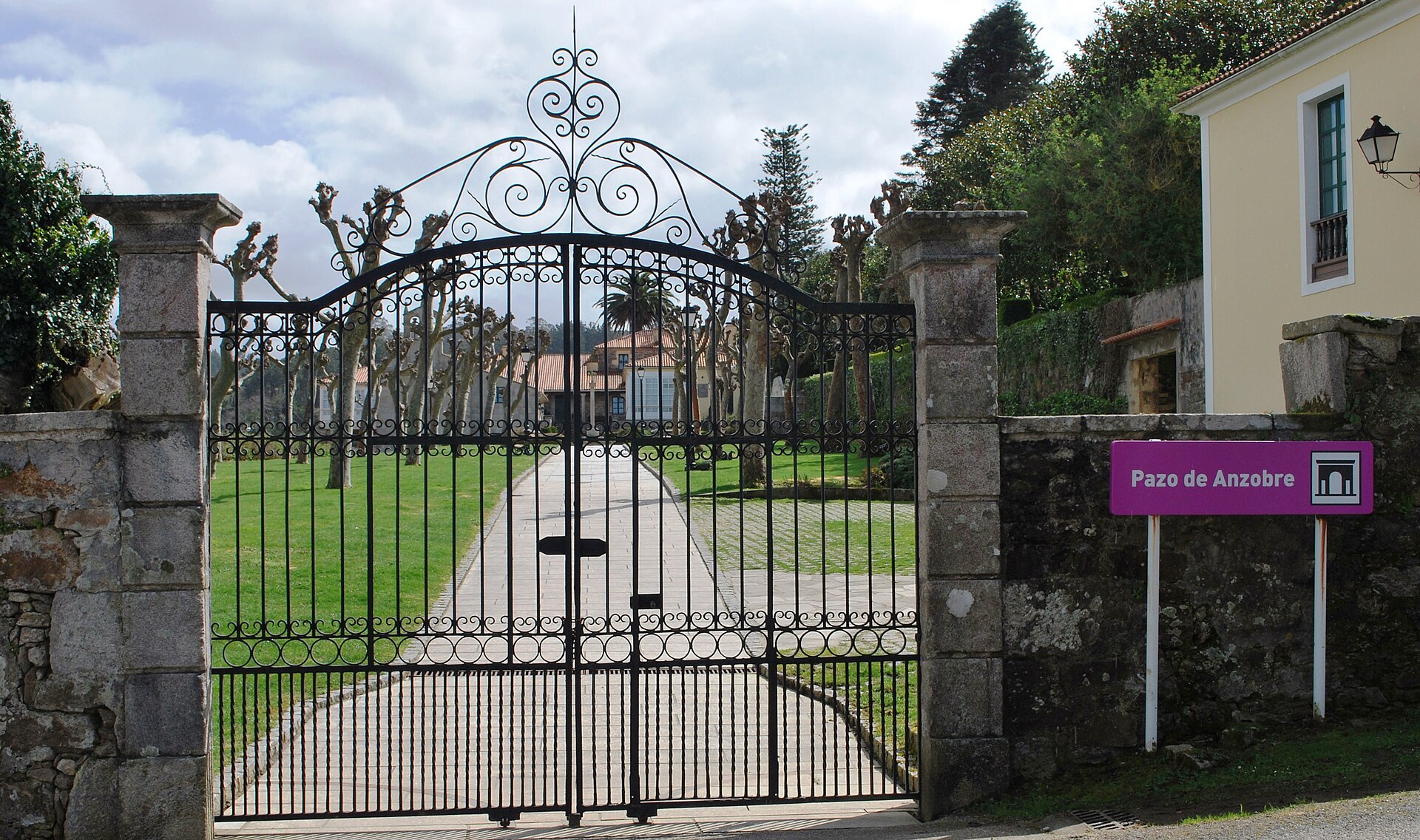
Pazo de Anzobre
Arteixo
Pazo de Anzobre is a 17th-century Galician manor house in the parish of Armentón, in the municipality of Arteixo, about 20 km from A Coruña. It sits on a hilltop overlooking a valley, surrounded by pine groves, meadows and cornfields, not far from Barrañán beach. What's the story behind this manor house? The estate was originally the property of the Suárez de Figueroa family, descendants of the first Figueroa lineage. Through marriage, the Anzobre estate passed to the Cisneros family, who in turn linked it to the Puga family of Ourense. For a period the pazo belonged to the Counts of Gimonde. When the Countess of Gimonde, Jacoba Cisneros de Puga, died in 1860, the property passed to her universal heir, Manuel María Puga Feijoo. This chain of marriages and inheritances explains why the building's facades display the coats of arms of no fewer than four noble families. What does the architecture look like? The pazo was built in stone masonry (cantería), with modern glazed galleries added later — a common feature of Galician country houses. The layout follows a U-shape, with a chapel attached to one wing and a porch at the center. On the chapel's facade, above the door and beneath a cross, sits the coat of arms of the House of Gimonde. Elsewhere on the main building, the coats of arms of the Castro, Moscoso, Figueroa and Soutomaior families mark the successive alliances and inheritances that shaped the estate from the 17th century onward. What happens at the chapel every year? The pazo's chapel is the setting for the romería de los Remedios, a traditional Galician pilgrimage and patronal festival held every August. It combines a religious procession with a local fiesta and draws residents from the surrounding parishes, making it one of the highlights of Arteixo's yearly festive calendar. Can you visit Pazo de Anzobre? Pazo de Anzobre remains private property, and its interior is not open to visitors. It can, however, be admired from the outside while walking the surrounding roads — the building's silhouette, the chapel, and the pine-and-farmland landscape around it are all visible to passersby. It makes a worthwhile stop for anyone exploring the Arteixo area or the nearby Barrañán beach, pairing a scenic walk with a glimpse of local noble history. How do you get to Pazo de Anzobre? The pazo lies in the parish of Armentón, municipality of Arteixo, in the province of A Coruña. The easiest way to reach it is by car from A Coruña (around 20 km) or from Barrañán beach, which sits close by. The surrounding countryside also suits walking and cycling routes that link the coast with the municipality's rural hinterland. When is the best time to visit? August stands out because of the romería de los Remedios, when the area around the pazo comes alive with local tradition and celebration. Outside that, spring and early autumn bring mild weather and the green scenery typical of Galicia, ideal for walking the lanes around the estate. Frequently asked questions Is Pazo de Anzobre open to visitors? No — it's private property and its interior isn't open to the public. You can still view it from the outside along the nearby roads. How old is the building? It dates from the 17th century, though more modern elements, such as glazed galleries, were added later. Which families are linked to the pazo's history? The Suárez de Figueroa, Cisneros and Puga families, along with the Counts of Gimonde — their coats of arms can still be seen on the building and its chapel. What is the romería de los Remedios? It's an annual pilgrimage and patronal festival held every August at the pazo's chapel, blending a religious tradition with a local fiesta.
Earn badges for the places you visit
Download NextOnTrip, discover new places and check off your trails.