Nature in Spain
A guide to 849 Nature in Spain — with descriptions, photos and traveler visits from the NextOnTrip community. Locations spread across 518 cities and towns. Most visited by the community: Comunero de Revenga, Dehesa de Navalcarbón, Painted Cave, Galdar.
-
El Piélago
Vilches
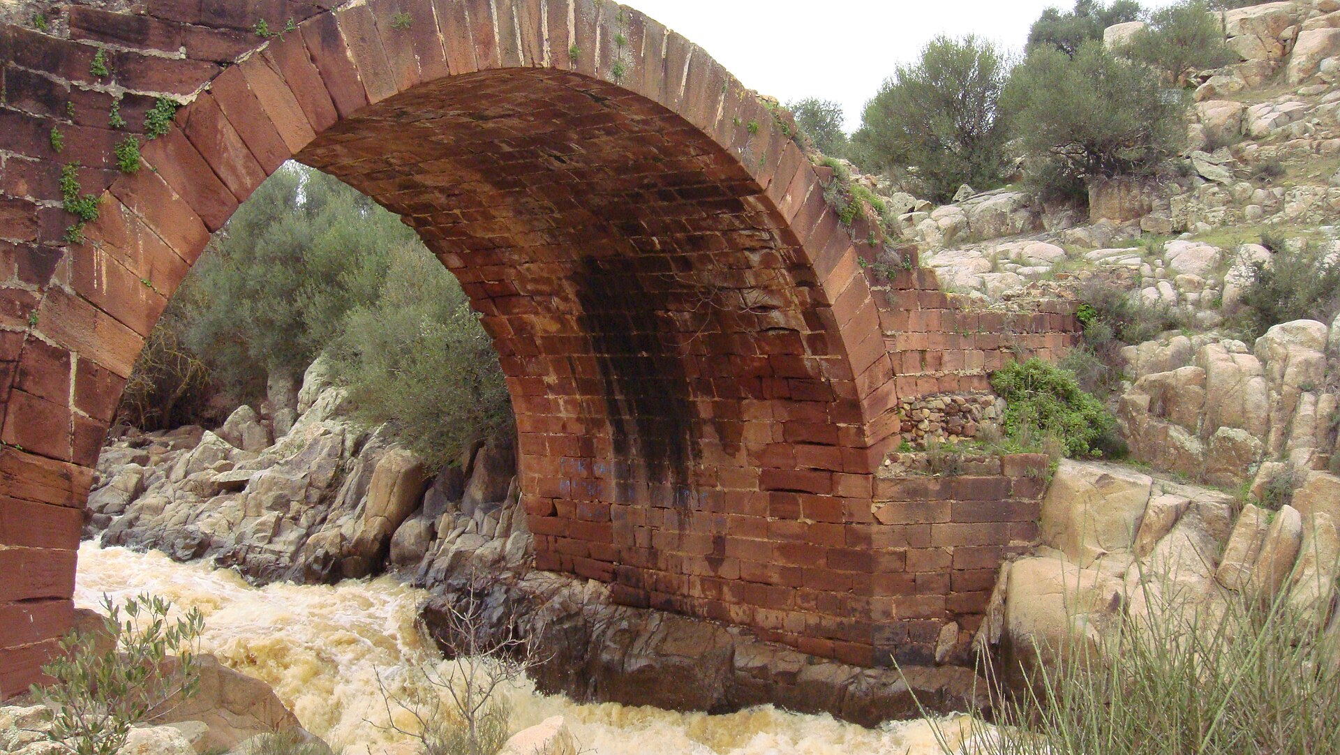
El Piélago is a natural monument spanning the municipalities of Vilches and Linares, in the province of Jaén, right where the open plains meet the first foothills of the Sierra Morena. The area was officially declared a Monumento Natural by the Andalusian regional government on 1 October 2003, and it is one of 28 such protected sites in Andalusia. What will you see there? The centerpiece is a stretch of the Guarrizas River, which cuts through massive granite outcrops and forms two striking waterfalls along the way. Over time the water has carved deep pools and narrow channels into the rock, giving the landscape a more rugged, almost mountainous feel than you'd expect from this part of Jaén. A riverside forest lines the banks, surrounded by wild olive trees (acebuches) and ash trees. This habitat supports a rich variety of birdlife — black kites, grey wagtails, grey herons and mallards are among the species you might spot, making the spot appealing for birdwatchers. History is the other big draw. The Roman bridge of Vadollano crosses the site, once part of the Via Augusta, the road that connected Rome with Gades — present-day Cádiz. The bridge was built specifically to overcome the steep elevation changes at El Piélago and keep metal shipments from the Sierra Morena mines moving. Just below it lie the ruins of an old chocolate factory that once harnessed the river's current to generate power — a small but telling trace of local industry tucked into an otherwise wild landscape. How do you get there? El Piélago sits between the towns of Vilches and Linares, in the province of Jaén, Andalusia. The easiest way in is by car from either town, both of which are close by and make a natural base for a visit. Given the terrain — granite rock and riverbed — sturdy footwear is worth packing, especially if you plan to walk to the waterfalls and the Roman bridge. When is the best time to visit? The Guarrizas River and its riverside forest look their best outside the peak of summer drought — spring and autumn bring higher water levels and more dramatic waterfalls. Summers in Jaén province can get very hot, which makes longer walks in open terrain harder going, though the shade of the riverside trees and the cool water become an attraction in their own right at that time of year. Early morning is the best window for spotting birds. Frequently Asked Questions What exactly is El Piélago? It's a natural monument along the Guarrizas River, covering land in the municipalities of Vilches and Linares in Jaén province, protected by the Andalusian government since 2003. What makes this place worth visiting? The combination of nature and history: granite rock formations with waterfalls, plus the Roman bridge of Vadollano, part of the ancient Via Augusta linking Rome and Cádiz. Are there any traces of industrial history at El Piélago? Yes — beneath the Roman bridge lie the ruins of an old chocolate factory that once used the Guarrizas River's water power to run its machinery. What wildlife can be seen here? The area is a notable spot for birds, with species such as black kites, grey wagtails, grey herons and mallards regularly recorded, making it a worthwhile stop for birdwatching enthusiasts.
-
Calisto and Melibea Vegetable Garden
Salamanka
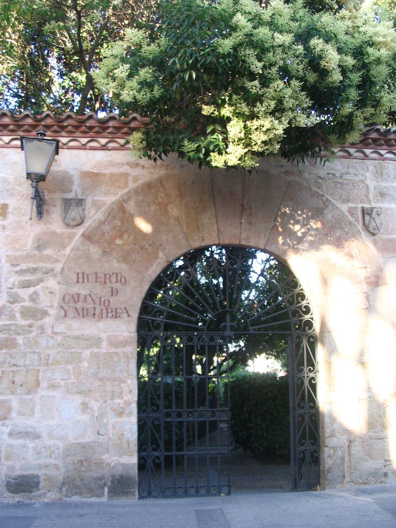
Calisto and Melibea Vegetable Garden is a small, intimate park tucked into the old city walls of Salamanca, stepping down the slope toward the Tormes river. Covering roughly 2,500 square metres, it's the kind of spot travellers usually stumble on while walking from the cathedral toward the riverside — and then come back to on purpose for the view. Where does the name come from? The garden takes its name from the two lovers at the centre of "La Celestina" (originally "Tragicomedia de Calisto y Melibea"), the late-15th-century tragicomedy by Fernando de Rojas, who studied at the University of Salamanca. The story of Calisto and Melibea's forbidden romance unfolds in a garden setting much like this one, which is why the city chose to give a real green space this literary name. It opened to the public on 12 June 1981, a date that also marked the strengthening of Salamanca's twin-town ties with Coimbra in Portugal. What will you see? Don't expect grand monuments here — the appeal is in the layout itself. Terraced beds of trees, shrubs and seasonal flowers follow the slope down toward the old defensive wall and the river below, so a walk through the garden mixes greenery with a close-up view of medieval stonework. The real highlight, though, is the lookout point at the top: from here you get an open view over Salamanca's cathedrals (both the old and the new), the Tormes river, and the tightly packed old town climbing the opposite bank. It's one of the few spots in the city where you can get that classic postcard shot without fighting a crowd. How do you get there? The garden sits inside Salamanca's historic centre, an easy walk of ten to fifteen minutes from the cathedral or the Plaza Mayor down through the old town's narrow streets toward the city walls. It's open to the public with no ticket or booking required. Given its modest size, a visit typically takes 15 to 30 minutes, which makes it an easy add-on to a longer walk through the old quarter rather than a destination in itself. When should you visit? Afternoon light works best here, when the sun catches the cathedral façades from across the river and the view from the terrace is at its sharpest. Spring and early summer bring the garden's plantings into bloom, while autumn colours pair well with the stone walls below. The park stays quiet year-round, so it suits both a quick pause between sights and a slower evening stroll. Frequently asked questions Is there an entrance fee? No — it functions as a public city garden open to residents and visitors alike, with no separate ticket booth. How long should I plan for a visit? Given its small footprint, 15 to 30 minutes is enough to walk the paths and take in the viewpoint. Why is the garden named after Calisto and Melibea? It's named after the two lovers in Fernando de Rojas's 15th-century tragicomedy, whose story plays out in a garden setting similar to this one. What can you see from the viewpoint? A panorama of Salamanca's cathedrals, the Tormes river, and the old town rising on the opposite bank.
-
Miribilla parkea
Bilbao
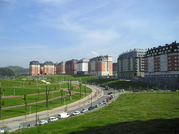
Miribilla Parkea is a hilltop city park in Bilbao that looks straight down over the old quarter below. Where is it and why does its history matter? The park sits on high ground in western Bilbao, right on the edge of the Bilbao la Vieja neighborhood and just above Casco Viejo. For nearly seven centuries the ground beneath today's lawns and footpaths was an active iron ore mine, feeding the industry and port trade that built up along the Nervión river. Once the deposits ran out, the site sat abandoned for decades, until the late 1990s brought a full urban redevelopment that turned it into the Miribilla neighborhood it is today. The mining past hasn't been erased entirely: a section of the old San Luis mine gallery survives nearby at Muelle de Marzana, open to visitors and giving a real sense of what the underground works once looked like. What is there to see? The park covers roughly 50,000 square meters, and its most striking trait is how steep and uneven the ground is — the site drops more than 40 meters over a stretch of just 200 meters. That elevation rewards visitors with wide views over Bilbao's rooftops and towers, the river, and the hills ringing the city. The spot has been valued as a lookout for centuries: locals were already climbing up here for the view back in the 15th and 16th centuries, and the outlook over Bilbao from this hill even appears on old maps in Abraham Ortelius's Theatrum Orbis Terrarum atlas. Today the grounds include sports courts, a fenced dog run, and walking paths. Right next door stands the Bilbao Arena sports complex with its basketball hall, and nearby you'll find Frontón Bizkaia, the largest Basque pelota court in the entire region. How do you get there, and when's the best time to go? The park is only about a five-minute walk from Casco Viejo, making it an easy add-on to a stroll through the old town. The neighborhood is served by Miribilla station, opened in December 2008, an unusual stop built roughly 50 meters underground and reached by panoramic elevators up to street level. Metro lines L1 and L2 also stop nearby, along with several bus routes (including 11, 30, 56, 57, 58, and 77). The park tends to stay quiet and uncrowded, which locals appreciate as a break from the busier streets below. The one time it draws real crowds is during Semana Grande, Bilbao's biggest annual festival — the height and open panorama make it one of the best spots in the city to watch the fireworks light up the sky. Frequently asked questions Is entry to the park free? Yes, Miribilla Parkea is a public city park open to everyone at no cost, every day. How far is it from the old town? It's about a five-minute walk from Casco Viejo, so it's easy to combine with a visit to the historic center. What else is worth seeing nearby? The Bilbao Arena sports complex, the Frontón Bizkaia pelota court, and the remains of the old San Luis mine at Muelle de Marzana are all close by. When is the best time to visit for the views? Semana Grande is the standout occasion — the park's elevated position makes it a favorite vantage point for watching the fireworks over Bilbao.
-

Sierras de Tejeda, Almijara y Alhama Natural Park
Cómpeta
Sierras de Tejeda, Almijara y Alhama Natural Park stretches above the village of Cómpeta in the province of Málaga, covering a mountain range with remarkably varied terrain — from coastal foothills to peaks rising past 2,000 metres. It is one of Andalusia's most ecologically diverse protected areas, where the Mediterranean coastal climate meets harsher high-mountain conditions. How did the park come to be, and what makes it distinctive? The area was declared a natural park in 1999, covering mountain ranges that stretch between the provinces of Málaga and Granada. Several access roads lead into the park from the Málaga side, passing through villages such as Alcaucín, Canillas de Aceituno, Sedella, Salares, Canillas de Albaida, Cómpeta and Frigiliana — each serving as a natural gateway into the mountains. The bedrock of these mountains is made primarily of local marble, giving the rock faces and cliffs their characteristic white and grey tones visible across many slopes. The highest peak in the range is La Maroma, rising over 2,000 metres, from whose summit visitors get one of the best views of the Costa del Sol, combining the Mediterranean Sea with the mountainous landscape of the park below. What plants and animals live in the park? An altitude range spanning from around 100 metres to over 2,000 metres, along with climatic variation and the range's southeast-to-northwest orientation, gives the park an exceptional variety of plant species, many of them rare or endemic. Pine forests dominate the landscape, including Aleppo pine, Scots pine and stone pine, alongside holm oak, gall oak and Pyrenean oak, interspersed with dense shrub cover such as box, dwarf palmetto, durillo and cambrón. Rarer species also thrive here, including fairy foxglove, purple columbine and the endemic Anthyllis tejedensis, while higher elevations preserve Mediterranean woodland of junipers, holm oaks and remnants of ancient yew groves — the southernmost surviving yew stands on the entire Iberian Peninsula. Wildlife in the park is dominated by wild mountain goats and iconic birds of prey such as the golden eagle and griffon vulture. Numerous other bird species also inhabit the area, including several types of eagle, the goshawk, the peregrine falcon, the black wheatear, the rock thrush and the alpine accentor. What can visitors do in the park from Cómpeta? The natural park surrounding Cómpeta is a hiker's paradise, with rugged terrain, deep valleys and pristine forests creating a landscape full of contrasts. The Sierra de Tejeda, with its jagged peaks and steep cliffs, offers demanding trails rewarded with views stretching all the way to the Mediterranean coastline. The neighbouring Sierra de Almijara conceals caves, waterfalls and abundant wildlife, making it an appealing destination for visitors seeking a closer encounter with untouched nature. Frequently asked questions How do you reach the park from Cómpeta? Cómpeta sits directly on the edge of the park, making it a convenient starting point for mountain trails. What is the highest peak in the park? La Maroma, rising above 2,000 metres, offers a panoramic view over the Costa del Sol and the Mediterranean Sea. Can you spot wildlife in the park? Yes — the park is home to wild mountain goats and numerous birds of prey, including the golden eagle and the griffon vulture.
-
Falla de Nigüelas
Nigüelas
Falla de Nigüelas is one of the most clearly readable records of tectonic movement in Spain — an exposed fault scarp that separates the Sierra Nevada massif from the Padul-Dúrcal depression, located in the municipality of Nigüelas in the province of Granada, within the Valle de Lecrín region. What can you actually see there? The main feature is a light-grey limestone-marble wall reaching roughly 25 metres in height. Its surface is remarkably smooth and polished — the result of two rock blocks grinding against each other over hundreds of thousands of years. Fine grooves and striations are visible across the rock face, and geologists read these marks to reconstruct the direction and history of the fault's movement. The full fault structure runs for about 15 kilometres along the base of the Sierra Nevada, though it's this short, well-exposed section that draws visitors and researchers alike. How did this formation come to be? Falla de Nigüelas is a normal fault: one block (Sierra Nevada) was pushed upward while the neighbouring block (the Padul-Dúrcal depression) sank. This process is directly tied to the uplift of the highest sections of the Betic Cordillera, the mountain range that includes the Sierra Nevada. In geological terms, the fault is considered relatively young, estimated at under one million years old. Its activity unfolded across several episodes, and today it is regarded as inactive, or "fossilised" — preserved in the shape it took during its last movements, without ongoing seismic activity. Why does it still interest scientists? Recent geological research found soft minerals within the fault zone that act as a natural lubricant between the sliding rock blocks. This discovery helps explain why the Padul-Nigüelas fault moves slowly and gradually instead of releasing built-up tension suddenly in the form of strong earthquakes. For seismologists, it's a valuable case study of how a fault's mineral composition shapes its long-term behaviour. Protection status Falla de Nigüelas was declared a Natural Monument (Monumento Natural) of Andalusia by the Junta de Andalucía on 23 November 2001. The protected area covers 7.6 hectares surrounding the fault wall itself. Frequently asked questions Is Falla de Nigüelas only interesting to geologists? Not at all — the fault wall is striking on its own, thanks to its height, colour, and smooth, polished surface. It also makes a good starting point for exploring the surrounding Valle de Lecrín. Is the fault still active, and is it dangerous? It's currently considered inactive, or "fossilised," at this location, and recent studies suggest its movements are slow and gradual rather than sudden and violent. Where exactly is it located? In the municipality of Nigüelas, in the Valle de Lecrín, in the province of Granada, at the foot of the Sierra Nevada. How long is the entire fault? The full fault structure extends for around 15 kilometres, though the visible, exposed wall covers a much shorter stretch.
-
Lagunas de Archidona
Archidona
Lagunas de Archidona is a natural reserve in the northeastern part of Málaga province, within the municipality of Archidona, made up of two neighboring bodies of water: Laguna Grande and Laguna Chica. It ranks among the most significant wetland sites in Andalusia, valued both for its geology and for its bird life. What are the Lagunas de Archidona? They are a pair of lakes shaped by karst processes and fed by sulfate-rich waters. The area sits within a zone known as Los Hoyos de Archidona, where water circulation happens mostly underground rather than on the surface — it is this intense karstification of the bedrock that governs how the lakes fill and retain water over time. Why is the site geologically distinctive? The surrounding terrain is dense with karst features: sinkholes, caves, sulfate-water springs, and fluviokarst channels. The karst complex here developed on a diapiric structure, which is unusual against the backdrop of the carbonate karst that typically dominates the region — a rarity that gives the site notable scientific value. How do the lakes behave through the year? Laguna Grande holds water almost year-round. Laguna Chica is more sensitive to climatic conditions and can dry up completely during particularly dry years, a pattern typical of shallow endorheic basins that depend on the balance between rainfall and evaporation rather than a steady river inflow. Why do the lakes matter for birds? This is one of the key sites in Andalusia for waterbirds, with the lakes drawing numerous species that use the area for feeding, resting during migration, or breeding. Water levels and salinity shape the vegetation and wildlife tied to the lakes, making the reserve an interesting spot for year-round nature observation. What should you know before visiting? The reserve sits in an easily accessible part of Málaga province, close to the town of Archidona, making it a convenient destination for anyone interested in nature, karst geology, or birdwatching. Because it is a protected area, visitors should take care not to disturb the natural environment, especially during the breeding season of waterbirds. Frequently asked questions Do the lakes always hold water? Laguna Grande almost always does; Laguna Chica can dry up completely in dry years. What makes the geology here rare? A karst complex developed on a diapiric structure, with numerous sinkholes and sulfate springs, unusual compared to the carbonate karst typical of the surrounding region. Who is this site for? Birdwatchers, geology enthusiasts, and anyone looking for a quiet nature destination in Málaga province.
-
Acantilados de Maro-Cerro Gordo
Acantilados de Maro-Cerro Gordo is a stretch of cliff-lined coastline on the border of Andalusia, sitting between Almuñécar in Granada province and Nerja in Málaga province. It marks one of the last undeveloped sections of Spain's Costa del Sol, where mountains drop directly into the sea and shape a landscape of coves, headlands and steep rock walls. What does the landscape look like? The protected area forms a narrow strip running parallel to the shoreline, roughly twelve kilometers long, and it also extends about a mile out to sea. The cliffs reach elevation differences of up to 250 meters. They are the coastal foothills of the Tejeda, Almijara and Alhama mountain ranges, carved over long periods by the constant action of sea waves. The result is a shoreline of small hidden coves, narrow beaches often reachable only on foot or by boat, and jagged cliff faces rising above the Alboran Sea. What lies beneath the surface? The underwater portion of this natural site is considerably richer in biodiversity than the land above it. The seabed supports extensive meadows of marine vegetation, including Posidonia oceanica and two Zostera species, which together create complex and biologically diverse habitats. These meadows serve as nurseries and feeding grounds for a wide range of fish and invertebrates. Of particular note is the presence of orange coral, a species classified as vulnerable to extinction, whose colonies rank among the most valuable elements of the local marine fauna. Why is the area protected? The site was designated a natural area (paraje natural) under Andalusian law in 1989. Since 2002 it has held status as a Special Protection Area for Birds, and since 2015 it has been recognized as a Special Conservation Zone within the European Natura 2000 network. Given its significance to Mediterranean ecosystems, the United Nations declared it a Specially Protected Area of Mediterranean Importance in 2003. These layered protections reflect how rare it is to find a stretch of coastline preserved in near-natural condition in a region where tourism development has claimed most of the shoreline. What can visitors do here? The area draws hikers who follow trails along the clifftops, divers and snorkelers exploring clear waters rich in marine life, and travelers looking for quieter beaches than those found in the neighboring resort towns. Coastal paths offer views over the open sea and the steep rock faces, while some of the coves can only be reached on foot or by kayak, which helps keep their natural character intact. Frequently asked questions Where exactly is Acantilados de Maro-Cerro Gordo located? It stretches along the Alboran Sea coastline on the border between Granada and Málaga provinces, between the towns of Almuñécar and Nerja. Can you swim here? Yes, the area includes small, secluded coves and beaches, though access to some of them can be difficult due to the steep, cliff-lined terrain. What makes this site ecologically distinctive? The combination of a dramatic cliff landscape on land with a rich, protected marine ecosystem below, including Posidonia meadows and populations of the endangered orange coral. What protection status does the area hold? It is a paraje natural protected since 1989, also part of the European Natura 2000 network and recognized by the United Nations as a specially protected area of Mediterranean importance.
-
Cueva de las Ventanas
Píñar
Cueva de las Ventanas is a karst cave in the municipality of Píñar, in the province of Granada, Andalusia, designated a Natural Monument and recognized as an archaeological site of major importance. The name, meaning "cave of windows," refers to natural openings in the rock face that let daylight into the interior, creating bright gaps visible even from outside. How far back does the site's history go? Traces of human presence inside the cave date back to the Upper Paleolithic, with the earliest occupation estimated at around 30,000 years before our era. Over the following millennia the cave served as a sanctuary, shelter and place of worship for a succession of communities. Archaeologists have found tools linked to the Upper Paleolithic, rock engravings dated to the transition between the Gravettian and Solutrean cultures, Neolithic and Chalcolithic pottery, Bronze Age implements, and even medieval ceramics. Romans, Visigoths and Almoravids also made use of the cave, leaving behind pottery fragments and other traces of their presence. What can visitors see on the tour? The tourist route covers roughly 500 meters and winds through a section of the cave illuminated by nearly 300 artistic lighting points that highlight the rock formations and give the interior an almost magical feel. A guided visit lasts about one hour. Cueva de las Ventanas is the only cave in the province of Granada open to visitors every single day of the year, and at the same time the only cave in Spain fitted out for visitors with reduced mobility. How do visitors reach the cave entrance? The cave was opened to tourism in 1999. Before the tour begins, visitors are taken up through the winding streets of the town of Píñar aboard a small tourist train, which reaches the cave entrance in about fifteen minutes, sparing guests the steep climb up the narrow hillside lanes. Why pair the cave with the rest of Píñar? The town of Píñar itself, spread picturesquely at the foot of a hill topped with the remains of an old fortress, makes a natural extension of a cave visit. The combination of karst scenery, views over the surrounding farmland, and the compact layout typical of villages in this part of Granada province means a trip to Cueva de las Ventanas can easily fill a whole morning or afternoon. Frequently asked questions How long does the cave tour take? The standard guided route takes about one hour and covers a section roughly 500 meters long. Is the cave accessible for visitors with reduced mobility? Yes — it is the only cave in Spain adapted for visitors with reduced mobility. Is the cave open all year round? Yes, it is the only cave in the province of Granada open to visitors every day of the year, regardless of season. Where does the name "cave of windows" come from? From natural openings in the rock wall that let daylight into the cave, also visible from the outside. Since when has the cave been open to the public? The tourist route opened in 1999, although traces of human presence in the cave date back to the Upper Paleolithic.
-
Punta de n'Amer
Sant Llorenç des Cardassar
Punta de n'Amer Punta de n'Amer is a peninsula and nature reserve on Mallorca's east coast, within the municipality of Sant Llorenç des Cardassar, sitting between the resort towns of Sa Coma and Cala Millor. Covering roughly 200 hectares and still privately owned, the site has held protected status as an Area of Special Natural Interest (ANEI) since 1985 — a designation that has kept one of the busiest tourist stretches of the island free of development at this particular spot. What is there to see on the peninsula? The cape reaches about two kilometers out into the Mediterranean, and a dense network of trails makes it possible to walk almost its entire perimeter on foot. The main landmark along the way is the Castell de la Punta de n'Amer, a 17th-century watchtower built as a lookout against pirate raids, part of the same chain of coastal defenses erected across the Balearic Islands during that period. Beyond the tower, the reserve also holds the remains of old military bunkers, an abandoned quarry, and several caves — traces of the different ways this stretch of coast has been used over time. What kind of nature does the cape protect? Within a relatively small area, several distinct habitats coexist: coastal dunes, scrubland, a pine grove, and rocky cliffs. This mix of environments makes Punta de n'Amer notable from a botanical and ecological standpoint, and it is home to species endemic to the Balearic Islands, found nowhere else. For visitors, that translates into a walk where the scenery shifts every few hundred meters — from sandy coves to dense scrub to steep, rocky shoreline. Is there any visitor infrastructure on site? Yes. The reserve has a small museum and a bar-restaurant open year-round, which makes it a comfortable destination for either a short stroll or a longer hike with a break along the way. Entry to the reserve is free, and the trails are well marked, so getting around without a guide is straightforward. Why visit if you're staying in Sa Coma or Cala Millor? Punta de n'Amer sits just a few minutes' walk from the crowded beaches and hotels of Sa Coma and Cala Millor, offering something quite different from the usual resort routine: quiet, natural scenery, and a historic watchtower with sea views. It's a rare chance, along Mallorca's heavily built-up east coast, to find a stretch of shoreline that has kept its original, undeveloped character. Frequently asked questions Is there an entrance fee for Punta de n'Amer? No, access to the reserve is free, and the trail network lets visitors plan their own walking route around the cape. How long does it take to walk the whole peninsula? Given the roughly two-kilometer reach into the sea and the branching trail network, a full loop that includes the castle and the main viewpoints usually takes around one and a half to two hours at a relaxed pace. What else is worth seeing besides the castle? Aside from the Castell de la Punta de n'Amer, look out for the remains of bunkers from the site's military past, an old quarry, and small caves tucked into the rocky sections of coastline. Is there anywhere to eat on site? Yes, a bar-restaurant operates year-round within the reserve, alongside a small museum covering the area's history and natural environment.
-
Marismas del Odiel
Huelva
Marismas del Odiel is a vast wetland area at the mouth of the Odiel River, in the province of Huelva, Andalusia, Spain. It ranks as the second largest wetland zone in the province after Doñana, stretching across parts of the municipalities of Gibraleón, Aljaraque, Punta Umbría and the southwestern edge of the city of Huelva. UNESCO designated the area a Biosphere Reserve in 1983, and it now covers 7,185 hectares, including the Natural Reserves of Isla de Enmedio and Marisma del Burro. How did this marshland form? The answer lies in geography: the Tinto and Odiel rivers meet near Huelva, and the mixing of their freshwater with incoming seawater, combined with the rhythm of the tides, produced a classic tidal marsh system functioning as an estuary. Both rivers carry large amounts of nutrient-rich sediment, which settles in shallow inlets and channels, gradually shaping a network of winding waterways, lagoons and salt flats. What is there to see on site? The landscape of Marismas del Odiel is surprisingly varied for a wetland. Visitors will find twisting waterways, lagoon basins and distinctive salt marshes, among them Bacuta, Aragonesas and Batán. The reserve also includes several islands — Enmedio, Saltes and Bacuta — along with the Espigón beach running along the coast. Wooded patches such as El Almendral, El Acebuchal and La Cascajera break up the open marsh scenery and provide shelter for numerous animal species. Why does this place matter for birds? Marismas del Odiel is considered the most important tidal marsh system on the entire Iberian Peninsula, and its significance for birdwatchers and nature lovers is hard to overstate. The area sits along a migratory route used by many wader species, making it a key stopover during their seasonal journeys. More than 250 bird species have been recorded here, several of them endangered. Among the most commonly observed are flamingos, spoonbills, herons and ospreys — birds of prey that feed on fish and are well adapted to hunting in the marsh's shallow waters. How is it different from a typical nature park? Marismas del Odiel is, above all, a living estuary system in which natural processes — tides, sediment deposition, the mixing of fresh and salt water — never stop, continuously reshaping the landscape. That sets it apart from static, land-based nature reserves: here, water, land and the boundaries between individual ecosystems keep shifting with the rhythm of the ocean tides. Frequently asked questions Where exactly is Marismas del Odiel located? The area lies in the province of Huelva, Andalusia, at the mouth of the Odiel River, covering parts of the municipalities of Gibraleón, Aljaraque, Punta Umbría and the city of Huelva. When did the area become a UNESCO Biosphere Reserve? It received this status in 1983 and now spans 7,185 hectares, including the Natural Reserves of Isla de Enmedio and Marisma del Burro. What birds can be seen here? More than 250 bird species have been recorded in the marsh, including flamingos, spoonbills, herons and ospreys, many of which are protected. Why do the marshes have such a winding shape? It results from a natural sedimentation process — the Tinto and Odiel rivers carry sediment that settles in shallow inlets, gradually forming a network of winding channels and lagoons.
-
Malpaís de la Arena
La Oliva
Malpaís de la Arena is a natural monument in the municipality of La Oliva, in the central part of Fuerteventura in the Canary Islands. Covering more than 870 hectares, it protects one of the geologically youngest volcanic landscapes on the island, shaped by an eruption that took place roughly ten thousand years ago. Where does this black landscape come from? At the heart of the protected area stands Montaña de La Arena, considered the youngest volcano on Fuerteventura. It has a roughly elliptical shape measuring about 760 by 510 metres and holds two craters. The cone rises around 120 metres above its base, with the summit reaching an altitude of about 420 metres above sea level. The eruption that built it spread wide lava fields across the surrounding terrain, giving the area the raw, dark appearance behind the name "malpaís" — literally "badland," a term used across the Canaries for ground covered in solidified lava. Why is this place important for nature? Since the eruption, the landscape has remained largely untouched by human activity. That lack of interference has turned Malpaís de la Arena into a refuge for vegetation typical of the archipelago's dry volcanic terrain. Plants such as tabaibas and aulagas grow here, both well adapted to extremely poor, rocky soil and minimal rainfall. Rich communities of lichen have also developed across the lava rock, and the surrounding scrub and rocky ground provide habitat for birds associated with this type of environment. Conservationists consider the plant and lichen populations found in this area among the best preserved of their kind anywhere in the Canary archipelago. What protection status does the area hold? The landscape and ecological value of the site were recognised as early as the 1980s. It was first protected under Law 12/1987 of 19 June, which established the network of natural spaces of the Canary Islands and classified the area as a Site of National Interest. That status was later refined by Law 12/1994 of 19 December on the Natural Spaces of the Canary Islands, under which the site was formally reclassified as a Natural Monument (Monumento Natural). What to know before visiting Malpaís de la Arena sits in the central part of La Oliva, one of Fuerteventura's three main municipalities, on the island's northeastern side, home to several well-known coastal resorts. Given the terrain — wide fields of jagged lava rock and a prominent volcanic cone — the site mainly draws visitors interested in geology, landscape photography, and the island's endemic dry-climate vegetation. Its stark, moon-like scenery contrasts sharply with the sandy beaches Fuerteventura is best known for, making it a worthwhile stop for travellers looking for something beyond the coastline. Frequently asked questions How large is the Malpaís de la Arena protected area? The natural monument covers approximately 870.8 hectares within the municipality of La Oliva. How old is the Montaña de La Arena volcano? The eruption that formed it is estimated to have occurred around ten thousand years ago, making it the youngest volcano on Fuerteventura. What protection status does the site have? It is officially classified as a Natural Monument under Canary Islands natural spaces legislation from 1994, having first been recognised as a Site of National Interest in 1987. What can visitors see there? Extensive fields of solidified lava, a two-crater volcanic cone, and vegetation typical of the Canaries' dry volcanic terrain, including tabaibas, aulagas, and lichens.
-
La Albufera Natural Park
Walencja
Albufera de València is a freshwater lagoon and estuary on the Gulf of Valencia coast, in Spain's Valencian Community, near the town of Sueca. It forms the main portion of the Parc Natural de l'Albufera de València, a protected area covering 21,120 hectares. As one of the largest wetland systems on Spain's eastern coast, it plays a central role in the region's natural landscape. How did the lagoon form? Despite being freshwater today, Albufera's origins tell a different story. It was originally a saltwater lagoon, connected to the sea. Over time, irrigation of surrounding farmland and canals draining into the estuary, combined with the gradual growth of sand bars separating the lagoon from the Mediterranean, steadily diluted the salt water. This transformation was so thorough that by the seventeenth century the lagoon had already become a freshwater body — a shift that shaped the ecosystem visitors encounter today. Why is this place ecologically significant? The reserve's natural biodiversity supports a wide variety of flora and fauna that can be observed year-round. The extensive wetlands, the surrounding rice paddies, and the network of canals create conditions favorable to numerous species tied to aquatic environments. It is precisely this biological richness that led to the area being protected as a nature park, with the lagoon itself remaining its central, defining feature. Where exactly is Albufera located? The lagoon sits on the Gulf of Valencia coast, in eastern Spain, directly adjacent to the town of Sueca. Its geographic coordinates are approximately 39.30° N, -0.33° E. This location places Albufera relatively close to the city of Valencia, making it a natural reference point for anyone exploring the region. What sets Albufera apart from an ordinary lagoon? What distinguishes Albufera from other lagoons of its kind is its scale and protected status. The 21,120-hectare surface area covered by the nature park makes it one of the larger protected areas in the Valencian Community. The lagoon itself forms the core of this system, surrounded by wetlands, irrigation canals, and rice fields that together create a distinctive transitional landscape between land and sea. Frequently asked questions Is Albufera de València a freshwater or saltwater lake? It is a freshwater body today, though it was historically a saltwater lagoon. The change happened gradually, mainly due to irrigation and canal drainage, and was complete by the seventeenth century. How large is the nature park surrounding the lagoon? The Parc Natural de l'Albufera de València covers 21,120 hectares, with the lagoon forming its main portion. Where is Albufera located relative to Valencia? It lies on the Gulf of Valencia coast, near the town of Sueca, within a short distance of the city of Valencia. What can visitors expect to see there? The area is known for the rich flora and fauna typical of wetland habitats, observable throughout the year thanks to the reserve's high biodiversity.
-
Saladas de Chiprana
Chiprana
Saladas de Chiprana is a complex of inland salt lakes located in the municipality of Chiprana, in the province of Zaragoza, within the Bajo Aragón-Caspe region of Spain. It is one of the very few places in Western Europe where a permanent, deep saline lake exists under a continental climate — a genuinely rare combination on the continent. What are the Saladas de Chiprana? The protected area consists of six endorheic lakes — lakes with no outlet to the sea, where water is lost only through evaporation. The largest and most significant is the Salada Grande, accompanied by the Salada de Roces, the Prado del Farol, and three smaller basins. The core nature reserve covers 155 hectares, surrounded by an additional peripheral protection zone of 361 hectares. What makes Salada Grande unique? Salada Grande reaches a depth of up to five metres, making it the only endorheic lake in Western Europe combining permanently saline water with such considerable depth. Unlike many other inland salt lakes, which typically dry out during summer, water levels here remain relatively stable throughout the year, peaking in May and dropping to their lowest in September. This stability sets it apart from other saline lakes on the Iberian Peninsula, many of which undergo seasonal desiccation cycles. What is the water like? The lake's salinity reaches around 80 grams of salt per litre. Interestingly, the dominant mineral is not sodium chloride but magnesium sulphate (epsomite), with common table salt present only in smaller quantities. This particular chemistry creates a highly distinctive environment that favours organisms adapted to extreme salt concentrations. Why is this site ecologically valuable? The bed of Salada Grande hosts a unique microbial mat, often compared by scientists to some of the earliest forms of life to appear on Earth. Thanks to this exceptional ecosystem and its excellent state of conservation, the area has been designated a Reserva Natural Dirigida (managed nature reserve) by the Government of Aragón, and it is also recognised as a Wetland of International Importance under the Ramsar Convention. Who is this destination for? Saladas de Chiprana appeals mainly to nature lovers, birdwatchers, and anyone interested in geology or limnology, the study of lakes. The reserve sits in a quiet, sparsely populated part of Aragón, away from mass tourism, making it a good spot for observing waterbirds and wetland species drawn to this unusual habitat. Frequently asked questions How many lakes make up the Saladas de Chiprana complex? Six endorheic lakes, the largest of which is Salada Grande. Why doesn't the water in Salada Grande dry up? Local hydrology keeps water levels relatively stable year-round, peaking in May and dropping to a minimum in September, unlike many other inland salt lakes on the Iberian Peninsula that experience seasonal drying. What protection status does the area have? It is a Reserva Natural Dirigida established by the Government of Aragón and is also listed under the Ramsar Convention as a wetland of international importance. What distinguishes this lake from other saline lakes in the region? Salada Grande is the only endorheic lake in Western Europe that combines permanent water, considerable depth (up to five metres), and high salinity.
-
Teide national monument
La Orotava
Teide National Monument is a protected natural area on Tenerife, forming part of the broader Teide National Park and one of the key pieces of the Canary Islands' nature conservation system. This natural monument covers a section of the volcanic landscape surrounding Mount Teide, the highest point in Spain, and carries its own protection status alongside the national park itself. What is Teide National Monument? It is a legally distinct protected area, established by regional law in 1994 as an additional layer of protection on top of the safeguards already provided by Teide National Park since 1954. The national park, spanning roughly 19,000 hectares, is the largest and oldest national park in the entire Canary Islands archipelago. The natural monument sits within the same geological structure — the Las Cañadas caldera — and is further recognised under the EU's Natura 2000 network as a Site of Community Importance. Why was this area protected? The reason lies in the region's exceptional volcanic and biological value. Mount Teide itself, rising to 3,718 metres above sea level, is the highest peak in Spain and the third-tallest volcanic structure in the world when measured from its oceanic base. Its last eruption occurred in 1909. The moon-like landscape, shaped by solidified lava flows, volcanic ash fields, and distinctive rock formations, was the basis for the inscription of Teide National Park on the UNESCO World Heritage List in 2007, under the natural heritage category. How does the monument connect to La Orotava? A significant share of the protected land — reportedly as much as 72% of the area — falls administratively under the municipality of La Orotava, one of the oldest and most historically significant towns on Tenerife. The Orotava Valley, stretching at the foot of the volcano, was inhabited since pre-Hispanic times by the Guanches, the island's indigenous people. Following the Castilian conquest in the 15th century, the valley developed into an important agricultural and cultural centre, and the town of La Orotava still preserves numerous examples of colonial-era architecture today. What surrounds Teide National Monument? The area borders Corona Forestal Natural Park, which, covering more than 46,000 hectares, is the largest protected natural area in the whole Canary Islands archipelago. This forested ring encircles the volcanic zone and acts as a buffer, shielding the park's upper reaches from settlement and tourism pressure originating in the island's lower areas. As a result, the protection system around Teide forms a continuous ecological corridor — from Canary pine forests to the stark high-mountain landscape surrounding the crater. Frequently asked questions How does Teide National Monument differ from Teide National Park? The natural monument is a separate legal protection category, established in 1994, running alongside the national park created in 1954 — both cover the same volcanic area but stem from different legal designations. How tall is Mount Teide? The summit reaches 3,718 metres above sea level, making it the highest point in Spain. When was the area added to the UNESCO World Heritage List? Teide National Park, which includes this area, was inscribed as a UNESCO World Heritage Site in 2007. Which town administers part of this territory? A large part of the area belongs to the municipality of La Orotava, a historic town at the foot of the volcano.
-
Souto da Retorta
Viveiro
Souto da Retorta is one of the most remarkable natural spots on the Galician coast — a eucalyptus grove protected as a Natural Monument, home to some of the largest trees in Europe. It lies in the parish of Chavín, within the municipality of Viveiro, on the right bank of the Landro River, roughly 6 kilometers from the town center. Why is this forest full of eucalyptus trees? The story of this place goes back to the turn of the 18th and 19th centuries, when the area was planted with eucalyptus trees. The goal was not tourism but drainage — the land was regularly flooded by the waters of the Landro River, and eucalyptus, a fast-growing species with a high water uptake, was well suited to drying out the soggy ground. No one at the time could have predicted the trees would eventually reach the scale that now draws visitors from across Spain. How many trees are there, and how big do they get? Across roughly 3.2 hectares grow close to 600 eucalyptus trees, many of them over a hundred years old and reaching impressive dimensions in both height and trunk volume. Because of this scale, Souto da Retorta is considered one of the sites with the largest eucalyptus specimens on the European continent. Who is the "Grandfather of Chavín"? The true star of the grove is a tree known as "O Avó" (The Grandfather), whose trunk exceeds 2.5 meters in diameter. It ranks among the largest single trees in Europe and is listed in the Galician catalog of singular trees. Its sheer size is striking even to visitors who have seen many old trees elsewhere — a living monument to more than a century of growth. What protection status does the site have? Souto da Retorta was declared a Natural Monument in 2000 and has since been part of the Galician Network of Protected Areas. This designation protects not only the trees themselves but the wider ecosystem that has developed around them over the decades. What is the visit like? The site is explored on foot, walking among the giant trunks along marked paths. The route continues toward a small power plant and a waterfall known locally as "o salto do can". The walk requires no special fitness and is suitable for most visitors, including families with children. Frequently asked questions Where exactly is Souto da Retorta located? In the parish of Chavín, municipality of Viveiro, on the right bank of the Landro River, about 6 km from Viveiro. Why are there eucalyptus trees here instead of native species? They were deliberately planted at the turn of the 18th and 19th centuries to drain land regularly flooded by the Landro River. What else is there to see besides the forest itself? The path also leads to a small hydroelectric plant and the "o salto do can" waterfall. Is the site legally protected? Yes, since 2000 Souto da Retorta has held Natural Monument status and forms part of the Galician Network of Protected Areas. How long does a visit take? Walking the main paths typically takes 30 to 60 minutes, depending on pace and how many stops you make at individual trees.
-
Reserva Marina de les Illes Columbretes
Reserva Marina de les Illes Columbretes is a protected marine area surrounding a small archipelago of volcanic islets in the Mediterranean Sea, roughly 30 nautical miles off the coast of Castellón, about halfway between the Balearic Islands and the Valencian mainland. The reserve covers close to 5,500 hectares of sea, while the emerged land totals only 19 hectares — 14 of which belong to the largest island, known as Illa Grossa or Columbrete Grande. How did the islands form? The Columbretes islands were formed during the Pleistocene, nearly a million years ago, through a series of underwater volcanic eruptions. The archipelago is made up of four groups of volcanic islets rising from a seabed that reaches depths of 80 metres. This rugged, barren landscape has long unsettled sailors, and the islands' name has been associated for centuries with a treacherous stretch of sea. What is the history behind the archipelago? For centuries the islands served as a hideout for smugglers and pirates, as well as a seasonal fishing base used until the early 19th century. During the 19th century the islets were deliberately burned to reduce reptile populations, and in 1856 a lighthouse was built there, marking the start of permanent settlement by the keepers who maintained it. Smuggling activity, on a smaller scale, continued into the 20th century. When and how were the islands protected? Formal protection began in 1988, when a decree by the Valencian regional government established a natural park covering the archipelago. Two years later, on 19 April 1990, a ministerial order created a marine reserve of 4,400 hectares around the islands. In 1994, protection was strengthened further when a law passed by the Valencian parliament reclassified the archipelago as a nature reserve, placing it under the highest level of environmental protection available in the region. What wildlife lives on the Columbretes? The archipelago is an important nesting site for seabirds, including Eleonora's falcon, the Audouin's gull, Cory's shearwater and the shag. Because of its position along the migratory route between Europe and Africa, the islands also serve as a key stopover point for migrating birds. On land, an endemic subspecies of the Iberian wall lizard — known as the Columbretes lizard — lives alongside at least ten endemic insect species. Underwater, visitors would find beds of kelp-like brown algae, colonies of red coral, and large populations of fish such as groupers, gilt-head bream and white seabream. The surrounding waters are also an important breeding ground for spiny lobster. Can you visit the Columbretes? Due to the fragility of the natural environment, visits are strictly limited. Only the largest island, Illa Grossa, can be visited, and only in small groups accompanied at all times by the reserve's rangers. The rest of the archipelago remains off-limits to visitors, which helps protect the nesting colonies and unique habitats found there. Frequently asked questions How far are the Columbretes from the mainland? The archipelago lies about 30 nautical miles off the coast of Castellón, roughly halfway between the Balearic Islands and the mainland. How old are the islands? They were formed during the Pleistocene, through volcanic eruptions that occurred nearly a million years ago. Can you visit the islands independently? No — access to Illa Grossa is only possible in small, organised groups accompanied by the reserve's rangers. Which birds nest on the Columbretes? Species such as Eleonora's falcon, the Audouin's gull, Cory's shearwater and the shag nest on the islands.
-
Tabernas Desert
Gérgal
The Tabernas Desert is the only true desert area in Europe, located in southeastern Spain, in the province of Almería, close to the municipality of Gérgal. This striking landscape covers a protected area of roughly 280 km² and stands out sharply from the typical Mediterranean scenery most visitors associate with Andalusia. Where is the Tabernas Desert located? The desert lies in the province of Almería, in the eastern part of Andalusia, in southeastern Spain. Its geographic coordinates are approximately 37°N, 2.45°W, placing it in a dry, inland stretch of the region. Gérgal, the neighboring municipality, serves as a natural reference point for anyone planning to visit the area. Why is it called Europe's only desert? The Tabernas Desert is commonly described as the only genuine desert on the European continent. This label is widely used and highlights just how unusual the site is compared to the rest of Europe, where this kind of extremely arid, desert-like terrain simply does not occur elsewhere. That single fact alone turns the area into a geographic curiosity and a one-of-a-kind landscape on a continental scale. How large is the protected area? The protected zone of the Tabernas Desert spans approximately 280 km². It's a substantial stretch of land placed entirely under protection, which reflects the natural and scenic value of the site. The scale of the area allows the desert to form a clearly defined, cohesive part of the Almería landscape, distinct from the surrounding terrain. What should visitors know before coming here? Anyone planning a trip to the area around Gérgal and the Tabernas Desert should keep in mind that this is a dry, distinctive terrain, unlike most well-known Spanish tourist destinations. The name itself — the Tabernas Desert — makes its arid character unmistakable, and its status as "the only desert in Europe" makes it a genuine point of interest for travelers looking for something out of the ordinary while touring Andalusia. Frequently asked questions Where exactly is the Tabernas Desert located? In southeastern Spain, in the province of Almería, near the municipality of Gérgal. How big is the Tabernas Desert? The protected area covers approximately 280 km². Is it really the only desert in Europe? The Tabernas Desert is widely known as the only desert in Europe, making it a unique location on the continent's map. What region of Spain is the Tabernas Desert in? It's in Andalusia, specifically in the eastern part of the province of Almería.
-
Ses Salines Natural Park
Ses Salines Natural Park stretches across the southern tip of Ibiza and reaches over to neighboring Formentera, covering both a strip of land and the sea channel between the two islands. It's one of the most distinctive landscapes in the Balearic archipelago — a mosaic of shallow salt ponds, dunes, pine groves and salt marshes that has served people for thousands of years and today shelters hundreds of animal and plant species. Where did the salt flats come from? Salt extraction here dates back to Phoenician times, around the 6th century BC. Over the following centuries, the resource passed through the hands of Carthaginians, Romans, the Muslim rulers of Ibiza, and later the Christian kingdoms that took control of the island. Production intensified notably during the 12th and 13th centuries, when salt became one of the pillars of the local economy. It was a valuable commodity because it allowed food to be preserved for long periods, so it traveled by sea to distant Mediterranean ports. Salt that helped build a city Revenue from the Ses Salines salt trade had a tangible impact on Ibiza's development — proceeds from salt sales helped finance the construction of the defensive walls of Dalt Vila, the historic fortified old town of the island's capital, now a UNESCO World Heritage site. For centuries the salt ponds remained one of the main sources of wealth for the island's inhabitants, with the extracted salt exported across the Mediterranean. How did its protected status evolve? The area's ecological value was formally recognized relatively recently. In 1995 it was designated a Nature Reserve, and in 2001 it was upgraded to the status of Ses Salines de Ibiza y Formentera Natural Park, strengthening the legal protection of its habitats and species. The area also falls within the territory recognized by UNESCO as World Heritage, alongside Ibiza's old town and the coastal ecosystems surrounding it. What can visitors see in the park? The park covers roughly 3,000 hectares of land and a further 13,000 hectares of sea stretching between Ibiza and Formentera. That makes it one of the largest protected areas in the Balearics, combining terrestrial and marine environments into a single ecological system. More than 210 bird species and nearly 180 plant species have been recorded within its boundaries, making it an important stop on the region's birdwatching map — especially during migration seasons. Frequently asked questions Where exactly is Ses Salines Natural Park located? The park sits at the southern tip of Ibiza and extends toward Formentera, also covering the sea channel between the two islands. How long has salt been extracted here? Evidence of salt exploitation dates back to Phoenician times, around the 6th century BC, and production continued uninterrupted through successive civilizations up to the present day. When was the area granted legal protection? It was designated a Nature Reserve in 1995 and received full natural park status in 2001. How large is the park? It covers about 3,000 hectares of land and 13,000 hectares of coastal sea. Can you go birdwatching in the park? Yes, more than 210 bird species have been recorded here, making Ses Salines one of the more important birdwatching sites in the Balearic Islands.
-
Western Valleys Natural Park
Valle de Hecho
Western Valleys Natural Park (Parque Natural de los Valles Occidentales) sits at the far western edge of the Aragonese Pyrenees, in the Jacetania region, with elevations ranging from roughly 900 to 2,670 metres above sea level. It protects two valleys — Hecho and Ansó — widely regarded as among the least altered corners of the Spanish side of the Pyrenees. Where exactly is the park located? The protected area spans the municipalities of Aísa, Ansó, Aragüés del Puerto, Borau, Jasa, Valle de Hecho and Canal de Berdún, all within the province of Huesca. The park borders France, with several of its high mountain ridges forming a natural frontier along the Pyrenean watershed. Its core is made up of two parallel, roughly south-to-north valleys, Hecho and Ansó, separated by intervening mountain ranges. How large is the protected area? The park itself covers 27,073 hectares, complemented by an additional peripheral protection zone of 7,335 hectares. The elevation gain within its boundaries — from around 900 metres on the valley floor up to 2,670 metres at the summit of Bisaurín — means the park spans several distinct ecological zones, from gentle valley bottoms to rocky, high-mountain ridgelines. What wildlife and plant life live here? This range of habitats is what makes the Western Valleys such a distinctive natural area. Beech forests, black pine woods, fir stands and extensive high-mountain pastures shelter species that have become rare elsewhere in the Pyrenean range. The most emblematic is the brown bear, which still roams these mountains, making the park one of the last strongholds for the species on the Spanish side of the border. Alongside it, visitors may come across signs of woodpeckers, bearded vultures and the endemic Pyrenean desman, while the mountain streams are home to the region's characteristic Pyrenean frogs. What else is there to see beyond the wildlife? The valley carved by the Aragón Subordán river, which runs through the park, contains the largest concentration of megalithic sites in all of Aragón — remnants of prehistoric settlement in these mountains. One of the Roman roads linking both sides of the Pyrenees also passed through the area, a reminder that these valleys have long served as a route connecting Spain and France. Villages within and around the park, such as Hecho and Ansó, have preserved living folk traditions and distinct Aragonese dialectal varieties still spoken by local residents today. Who is this park suited for? The Western Valleys appeal above all to hikers and nature lovers seeking an alternative to the more crowded stretches of the Pyrenees. The extensive pastures, beech woodlands and rocky ridgelines offer routes ranging from a few hours to multi-day treks through landscapes with a strongly preserved natural character. Its proximity to the French border also makes it a good base for planning cross-border routes that link both sides of the range. How do you get there? The park lies in the province of Huesca, within the Jacetania region, and is most easily accessed via the villages of Hecho or Ansó, which serve as the natural gateways into the protected area. Both valleys are connected by local roads leading up into the mountains, although the road network in the park's higher reaches remains limited — part of what helps preserve its wild character. Frequently asked questions Can you spot brown bears in the park? Yes, this is one of the last areas in the Spanish Pyrenees where the species still occurs, though sightings remain rare. What is the elevation range within the park? The terrain rises from about 900 metres on the valley floor to 2,670 metres at the summit of Bisaurín. Which municipalities lie within the park? Aísa, Ansó, Aragüés del Puerto, Borau, Jasa, Valle de Hecho and Canal de Berdún.
-
Parc de Montesquiu
Montesquiu
Parc del Castell de Montesquiu Parc del Castell de Montesquiu is a protected natural area in the northern part of the Osona region in Catalonia, spread across four municipalities: Montesquiu, Sant Quirze de Besora, Santa Maria de Besora and Sora. It covers more than 546 hectares, with the Ter River running through it and splitting the land into two uneven sections — a larger, more varied stretch on the left bank and a smaller, gentler one on the right. Where exactly is the park located? The park sits at the meeting point of the eastern Pre-Pyrenees and the Osona plains, where the rugged landscapes of Ripollès and Cerdanya give way to the more agricultural lowlands of the region. This transitional position has made the area attractive for human settlement since ancient times, thanks to reliable water access, fertile soil and the natural defensive advantage offered by its terrain. What is the history behind the castle? At the heart of the park stands the Castell de Montesquiu, whose earliest traces go back to the early Middle Ages. The building is believed to have originated as a small rectangular watchtower, likely constructed between the 10th and 11th centuries, built purely for defensive purposes to control access to the valley below. Over time, this modest stronghold expanded considerably. A turning point came in the mid-14th century, when the structure gradually shifted away from a purely military role and became a fortified family residence rather than just a defensive outpost. Further changes arrived in the 17th century, when Lluís Descatllar commissioned a chapel and expanded the northern wing of the castle, giving it a new architectural character. The castle's current, palatial appearance dates back to the early 20th century, thanks to Emili Juncadella, a prominent figure of the Catalan upper bourgeoisie of the time. He reshaped the building into the picturesque, castle-like form it retains today and added the surrounding gardens, which remain part of the park's landscape. What kind of nature surrounds the castle? The park lies on the boundary between the submediterranean and central European biogeographic zones, which gives it an unusually rich variety of vegetation. Forests dominate the landscape, ranging from oak groves to red pine stands and beech woods, forming a mosaic of plant communities that shifts depending on slope orientation and altitude. This habitat diversity also supports a varied fauna typical of northern Catalonia's transitional climate zones. What can visitors do here? A network of hiking trails winds through the park's forests and meadows, offering views over the Ter valley and the surrounding hills. The area draws hikers, birdwatchers and cyclists looking for a quieter alternative to more crowded mountain routes. Its gentle terrain and accessible paths also make it a popular spot for family picnics and outdoor outings for visitors of all ages. The castle itself has been adapted for visits and, beyond its historical role, now also serves as a venue for meetings, seminars and educational activities, combining architectural heritage with an active use of the space. Frequently asked questions Which municipalities does the park span? Montesquiu, Sant Quirze de Besora, Santa Maria de Besora and Sora. Which river flows through the park? The Ter River, which divides the area into two sections with distinct characters. When was the castle built? Its oldest elements date to the 10th–11th centuries, while its current, palace-like appearance was shaped in the early 20th century by Emili Juncadella. Can visitors tour the castle? Yes, the building is open for visits and is also used for meetings and educational activities.
-
Ullal de Baldoví
Sueca
Ullal de Baldoví is a natural freshwater spring rising from the ground in the municipality of Sueca, in the province of Valencia. It lies within the Albufera Natural Park, right beside the small hill known as Muntanyeta dels Sants, and belongs to a select group of local springs called "ullals" — groundwater outlets that have fed the surrounding wetlands and rice fields with clean water for centuries. What exactly is an ullal? The word "ullal" comes from Valencian and literally means "eye," referring to a spot where groundwater reaches the surface and forms a small, usually rounded pool. Unlike the main body of the Albufera lagoon, which is fed mostly by surface runoff and rainwater, ullals draw their water directly from underground aquifers, which makes them noticeably clearer and cooler than the surrounding wetland. How big is Ullal de Baldoví? It ranks among the largest and most significant springs of its kind in the entire park. The central pool covers an area of several thousand square meters, and at its deepest points, where water actually emerges from the bottom, depth reaches several meters. The spring's discharge has been measured at well over a hundred liters per second, at times exceeding two hundred, making it one of the most powerful groundwater outlets in the Albufera area. Why does it matter ecologically? Thanks to a constant supply of clean, oxygen-rich groundwater, Ullal de Baldoví has managed to preserve plant and animal species that have all but vanished from the rest of the Albufera wetlands due to pollution and decades of agricultural transformation. Among them are native freshwater crustaceans, freshwater mussels, and the endangered samaruc (Valencia hispanica) — a small fish endemic to the eastern coast of the Iberian Peninsula and one of the flagship species for conservation efforts in the Valencia region. What happened to it over the years? For decades the area surrounding the spring suffered heavy human alteration — land reclamation, farming, and tourist pressure all took a toll on the local ecosystem. That changed with the European LIFE-Ullals project, which carried out an ecological restoration of the site: invasive species were removed, native aquatic and riparian vegetation was reintroduced, and animal species that had disappeared from the area were brought back. What can visitors expect today? Ullal de Baldoví is accessible via a marked nature trail that winds through the surrounding wetlands and vegetation. Along the way sits a small observation point, from which visitors can quietly take in the water and the plant life around it without disturbing local wildlife. It's a contemplative walk rather than an active one — best enjoyed outside peak tourist season, when the wider Albufera area is quieter. Frequently asked questions Where exactly is Ullal de Baldoví located? In the municipality of Sueca, within the Albufera Natural Park, next to the Muntanyeta dels Sants hill. Can you swim in Ullal de Baldoví? No — it's a protected natural area with a fragile ecosystem, so swimming and entering the water are not permitted in practice. How is an ullal different from the rest of the Albufera lagoon? An ullal is fed directly by groundwater rising from underground aquifers, making it clearer and cooler than the shallow, surface-fed lagoon around it. What species can be found here? Notably the endangered samaruc fish, along with native freshwater crustaceans and mussels that have become rare elsewhere in the Albufera.
-
Isla de San Andrés
Carboneras
Isla de San Andrés is a small volcanic islet complex off the coast of Carboneras, in the province of Almería, sitting right in front of La Puntica beach. It acts as a natural gateway to the Cabo de Gata-Níjar Natural Park and holds official protection as a Natural Monument, declared by decree of the Andalusian regional government in 2003. What does the island look like? Seen from above, the two rocky islets that make up the site form a shape often compared to a whale — the larger one known as Isla Grande and the smaller as Isla Chica. Both are low-lying and sit very close to the mainland, making them easy to spot from the beach without needing a boat. Their volcanic origin gives the rock a dark, rugged texture that stands out sharply against the pale sand of the nearby shoreline. What lies beneath the water? The real richness of this site is underwater. Extensive meadows of Posidonia oceanica, a flowering plant endemic to the Mediterranean, surround the islets and perform several essential ecological functions: they prevent coastal erosion, oxygenate the water and keep it clear. These meadows support a wide range of marine life, including groupers, corvinas, cuttlefish, octopuses and crabs, which feed and spawn among the seagrass. The condition of these underwater habitats is one of the main reasons the area was placed under legal protection. Which animals can be spotted here? Above the waterline, Isla de San Andrés is an important site for seabirds. Visitors may observe shearwaters, cormorants and storm petrels around the rocks. Some species, such as the yellow-legged gull, use the islets as a nesting ground, adding further ecological value to this small but biodiverse stretch of coastline. Does the island also have historical significance? Yes — beyond its natural value, Isla de San Andrés carries a cultural dimension as well. Traces of a Hispano-Muslim necropolis have been found on the site, giving it additional historical and heritage interest. The presence of such an archaeological find on such a small, isolated location suggests that the surroundings of Carboneras were inhabited and used by people long before the area's modern tourism development. Why is it worth a look? Isla de San Andrés packs geology, marine biology, birdlife and history into a very small area. Its proximity to La Puntica beach makes it a natural landmark for anyone visiting this stretch of the Almería coast, while its status as a Natural Monument underlines how ecologically significant this small fragment of Andalusian shoreline is, despite its modest size. Frequently asked questions Can you walk onto the island? Isla de San Andrés is a protected Natural Monument, and its main conservation goal is to safeguard seabird nesting habitats and the underwater Posidonia meadows — access and activities in such protected areas are regulated by nature conservation rules. Where exactly is it located? The islets lie off the coast of Carboneras, in the province of Almería, directly in front of La Puntica beach, east of the Cabo de Gata-Níjar Natural Park. What animals live around the island? The surrounding waters are home to groupers, corvinas, cuttlefish, octopuses and crabs, while seabirds, including the yellow-legged gull, nest on the rocks above. What gives the island its protected status? The site was declared a Natural Monument under Decree 250/2003, issued on 9 September 2003 by the Andalusian regional government.
-
Paraje Natural Municipal La Torrecilla-Puntal de Navarrete
Altura
Paraje Natural Municipal La Torrecilla-Puntal de Navarrete is a protected natural area in the municipality of Altura, in the province of Castellón, stretching to the boundaries with the neighbouring municipalities of Jérica and Alcublas. Covering more than 331 hectares, it was granted municipal natural park status in 2006 in recognition of its outstanding ecological and cultural value. What kind of landscape does the park have? The terrain is distinctly karstic — layered rock formations have carved out steep ridges, deep gorges, scree slopes and natural rock shelters across the area. Pine forests grow at the foot of these formations, and the combination of rugged limestone crags with green woodland gives the park a landscape of remarkable scenic and environmental quality. It's this contrast between bare rock and dense forest that sets the area apart from other protected spaces in the region. What grows here? The vegetation is dominated by mixed forests of black pine and kermes oak, with an understorey of junipers, including the valuable Spanish juniper. One section of the park, known as Puntal de Navarrete, has such a distinctive plant community that it was designated a separate flora microreserve. The priority species protected here include the knapweed Centaurea pinae, the Spanish juniper (Juniperus thurifera) and a species of the genus Teucrium — angustissum. The black pine forests with Spanish juniper are classified as a priority habitat at European Union level, underlining how significant this small pocket of woodland is for nature conservation. What history is hidden on Torrecilla hill? At the summit of Torrecilla hill lies an archaeological site of Iberian origin, considered one of the most important of its kind in the wider Alto Palancia region. The remains of the settlement point to a clearly defensive purpose — the site was used to control and watch over the roads passing through the area, as well as the small springs that emerge at the base of the hill. For visitors interested in the region's ancient past, this is one of the park's most compelling features. What can visitors do in the park? Paraje Natural Municipal La Torrecilla-Puntal de Navarrete is a popular destination for outdoor enthusiasts. Marked routes are suited to hiking, touring cycling, mountain biking and road cycling, as well as jogging. Visitors will find a parking area, drinking fountains, information panels describing the site's natural and historical features, and a dedicated recreational area known as Las Torrecillas, where it's possible to rest in the shade of the trees. Frequently asked questions Where exactly is this park located? It lies within the municipality of Altura, in the province of Castellón, on land that borders the municipalities of Jérica and Alcublas. Is there anything of historical interest here? Yes — the summit of Torrecilla hill holds one of the most important Iberian archaeological sites in the Alto Palancia region, with clear defensive characteristics. What activities are available in the park? Hiking trails, cycling routes (both mountain and road), and jogging, supported by facilities such as parking, drinking fountains and a recreational area. Why is the vegetation here considered special? Because of its unique composition, part of the park — Puntal de Navarrete — has been designated a flora microreserve, protecting rare species such as the Spanish juniper.
-
Hayedo de Montejo
Montejo de la Sierra
Hayedo de Montejo is one of Spain's most unusual woodlands — a beech forest tucked into the hills near Montejo de la Sierra, within the Sierra de Ayllón mountain range, roughly 100 km north of Madrid. The forest itself covers only about 250 hectares, yet its ecological significance far outweighs its modest size. What makes this forest so unusual? Beech trees (Fagus sylvatica) are normally associated with the cooler climates of northern and central Europe. Hayedo de Montejo, however, sits at one of the southeasternmost points where this species survives on the continent. The trees have endured here thanks to a peculiar microclimate created by the surrounding valley: the shade cast by the slopes and the humidity trapped within them produce conditions that shouldn't, by all rights, support beeches this far south. That oddity is precisely what has drawn the attention of scientists and naturalists from across Europe. A concentration of biodiversity Despite its small footprint, the forest and its surrounding reserve host a striking density of life — an estimated 833 plant species and around 194 vertebrate species, several of them endemic to the area. This richness has earned Hayedo de Montejo a reputation as a living laboratory: researchers use it to study how climate change affects beech forests growing at the very edge of their natural range. Protected status The forest lies within the Sierra del Rincón Biosphere Reserve, recognized by UNESCO. In July 2017, Hayedo de Montejo received further international recognition when it was added to the UNESCO Natural World Heritage list, as part of a transnational inscription covering ancient and primeval beech forests across Europe. This dual status — biosphere reserve and World Heritage site — underscores just how rare and valuable this pocket of forest north of Madrid really is. Visiting the forest Because the ecosystem is so fragile, access is tightly controlled. Visits are only possible in the company of environmental educators, who guide small groups along designated trails. Entry is free of charge, but the number of daily visitor slots is limited, so booking ahead is essentially mandatory — especially in autumn, when the beech leaves turn their characteristic fiery colors and demand for visits peaks. Frequently asked questions Where exactly is Hayedo de Montejo located? The forest lies within the municipality of Montejo de la Sierra, in the northeastern part of the Community of Madrid, within the Sierra de Ayllón mountains. Is there an entrance fee? No — guided visits led by environmental educators are free, though the daily number of available spots is limited. Why is this beech forest considered so unusual? Because it grows far south of the species' typical European range, surviving here thanks to a local microclimate that provides enough shade and moisture for the trees to thrive. Does the forest have any protective designation? Yes — it forms part of the Sierra del Rincón Biosphere Reserve and, since 2017, has also been inscribed as a UNESCO World Heritage site.
Earn badges for the places you visit
Download NextOnTrip, discover new places and check off your trails.