Coast in the United Kingdom
A guide to 161 Coast in the United Kingdom — with descriptions, photos and traveler visits from the NextOnTrip community. Locations spread across 86 cities and towns. Most visited by the community: Lizard Lighthouse Heritage Centre, New Quay, Nash Point Lighthouse.
-

Start Point Lighthouse
South Hams
Start Point Lighthouse sits on the Start Point headland in Devon, in the parish of Stokenham in the South Hams district on England's south coast. It is a working Trinity House light and one of the most atmospheric stops on this stretch of coast, perched above the cliffs not far from the villages of Torcross and Beesands. What is it, and when was it built? Trinity House engineer James Walker designed the lighthouse, and it was completed in 1836 to guard shipping rounding the headland. The tower is granite, topped with a cast-iron lantern under a copper roof. Historic England listed it at Grade II in 1991, and the neighbouring well house and old piggery from the same period carry the same grade. How has it changed over time? The first light proved weak in fog, so a fog signal was added. It began as a bell driven by machinery in a building beside the cliff, and in 1877 a siren took over. The bell then moved to the Plymouth Breakwater lighthouse. Erosion later undermined the fog signal building, which collapsed around 1989 or 1990. Since then an electric signal has sounded from the tower's gallery. The lighthouse was automated in 1993 and is now monitored from the Trinity House control centre in Essex. In 2018 an LED lantern replaced the rotating optic, and the old lens is displayed in the visitor centre. Can you visit? Yes. The lighthouse opens to visitors in the summer months, with a small exhibition on its history at the site. Hours vary by season, so check the Trinity House website before you go. The approach follows the South West Coast Path, so wear sturdy footwear. When should you go, and what should you wear? Summer is easiest: the lighthouse is open and the days are long. The headland is exposed to wind and rain, so pack a warm layer and a waterproof even on a bright day. The views take in cliffs and the open English Channel. What else is nearby? The coast path links the lighthouse with Beesands, Torcross and Start Bay, which makes it a good anchor for a full day's walk with a lunch stop in one of the seaside villages. Frequently asked questions Who owns Start Point Lighthouse? Trinity House, the authority responsible for navigation aids around the coasts of England and Wales. Is it still in service? Yes. It has run automatically since 1993 and is controlled remotely from Essex. Is the lighthouse a listed building? Yes. Historic England has listed it at Grade II since 1991. Is this the same as Start Point Lighthouse in Orkney? No. A different lighthouse with the same name stands on Sanday in Orkney. This one is in Devon, in southern England.
-
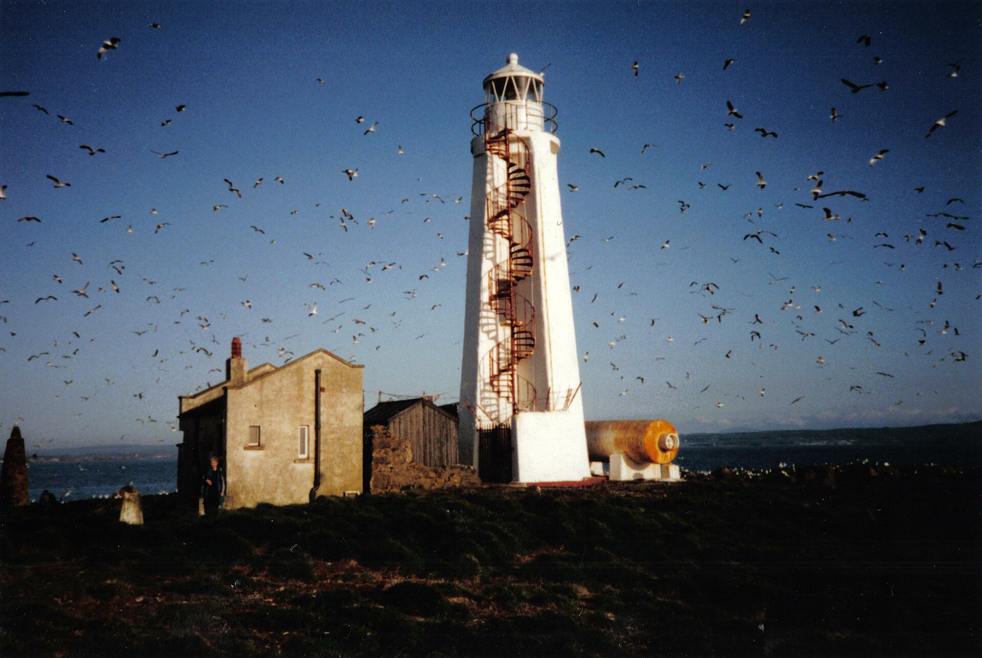
Lady Isle Lighthouse
Troon
Lady Isle Lighthouse stands on the uninhabited islet of Lady Isle in the Firth of Clyde, about two miles off the harbour town of Troon in South Ayrshire, Scotland. It is a sight to admire from the shore or from the water: visitors cannot land on the island. What kind of lighthouse is it? The Northern Lighthouse Board built it in 1902-03 to designs by David Alan and Charles Stevenson, of the famous Scottish lighthouse-building family. The light first shone on 27 January 1903. It was commissioned after requests from the Glasgow & South-Western Railway, which owned Troon harbour, and from ship masters. Its job was to mark the rocks around the island and guide vessels towards Troon and Irvine. The tower is unusual: four concrete buttresses joined together form a cross on plan. Historic Environment Scotland gives its height as up to 19 metres. It first burned gas, switched to acetylene around 1943, and went solar around 2004. What else is on the island? About 75 metres east of the lighthouse sits an older stone beacon, one of two raised by the city of Glasgow around 1776 as a navigation aid. The island also once had a chapel dedicated to St Mary, and it has a freshwater spring. Both the lighthouse and the beacon have been Category B listed buildings since December 2020. Can you visit the island? No. Lady Isle is privately owned and has long served as a seabird refuge, so there is no regular public access. The lighthouse is automated and does not offer tours. A holiday-let listing for the lighthouse has existed in the past, but check current terms with the operator rather than counting on it as a visitor attraction. How do you see it? The easiest way is from the coast around Troon and Barassie on a clear day, ideally with binoculars. The island also lies within view of boat trips on the Firth of Clyde. Troon is simple to reach, with a railway station on the line from Glasgow and Ayr. When should you go? Clear days give the best views, and long summer evenings offer good light for photos. From the beach the lighthouse is a small silhouette on the horizon, so a telephoto lens helps. Frequently asked questions Can I land on Lady Isle? No. The island is private and closed to visitors. Who designed the lighthouse? David Alan and Charles Stevenson; the Northern Lighthouse Board completed it in 1903. Is the light still working? Yes. It is automated and solar powered. Where is the best place to see it? From the shoreline near Troon, or on a cruise on the Firth of Clyde.
-
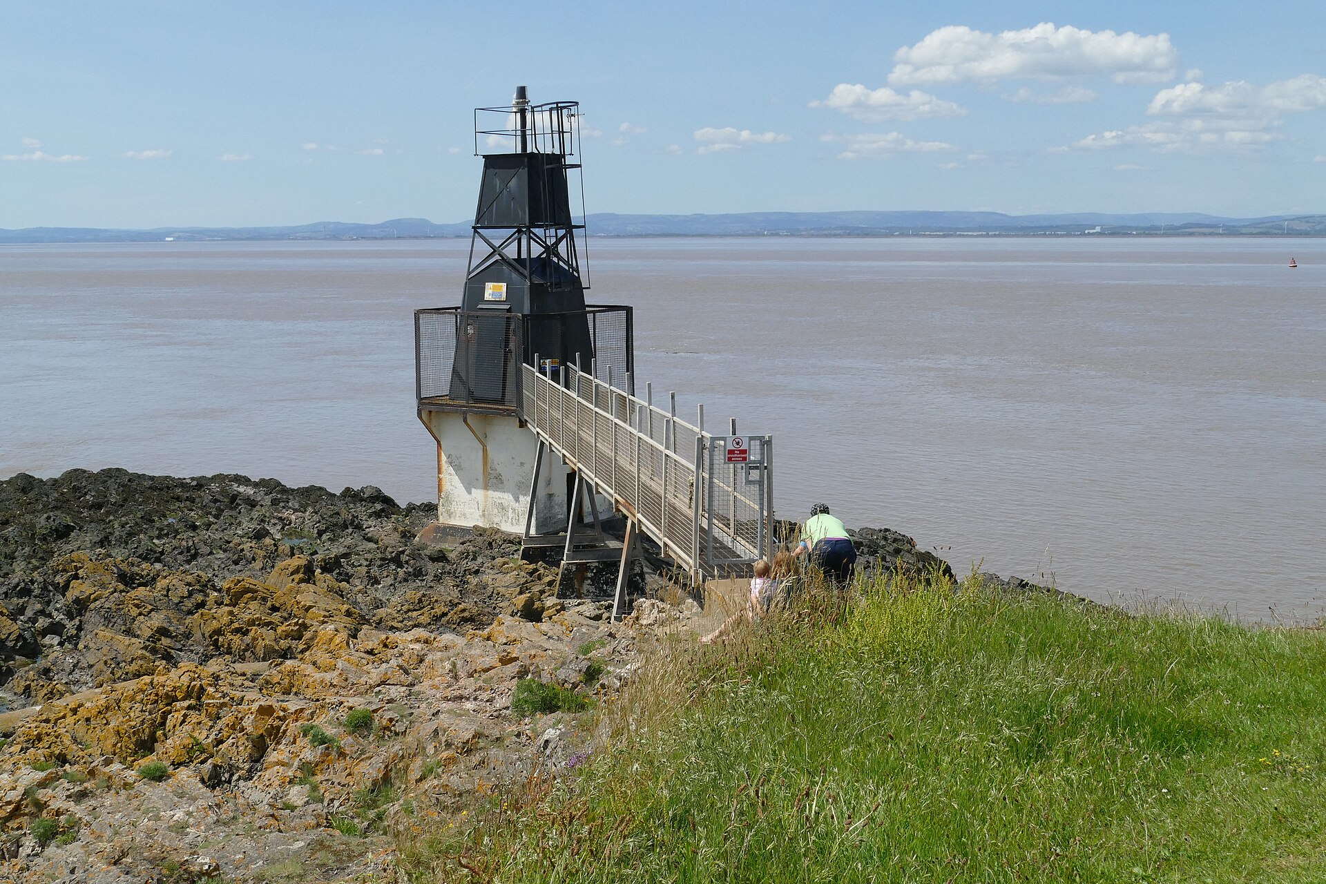
Portishead Point lighthouse
Portishead
Portishead Point lighthouse marks Battery Point in Portishead, a coastal town in Somerset, England, where the Severn Estuary narrows toward Bristol. It is a small black metal tower rather than a grand landmark, but it guards the approach to the Bristol port and makes a rewarding short walk with open views over the water. What is this lighthouse? The official name is Portishead Point, though locals mostly call it Battery Point after the headland. It went up in 1931 as an unwatched automatic light, with no keeper in residence. Chance Brothers of Smethwick built it. The tower stands about 9 metres tall and takes the form of a black metal pyramid on a concrete base. One lighthouse database gives 1930 for the light's establishment, so you may see a year's difference between sources. The Bristol Port Company looks after it. It is a working navigation aid, not a visitor attraction, so you admire it from outside. Why is it here? Off Portishead, ships pass closer to the mainland than anywhere else on the British coast. That made the point strategically useful for centuries. The site has had an Elizabethan watch-tower, a Civil War battery, Victorian coastal gun positions and defences from both world wars. The name Battery Point comes from that military past. The lighthouse once had a fog bell fitted when it was built. It was taken down in the late 1990s over concerns about the structure. You can see the bell today on Wyndham Way, close to Portishead High Street. How do you get to Battery Point? A flight of steps beside the open-air pool and the Lido Cafe leads up to the point. Another route is the path from the Eastwood side. Badger setts sit near the top of the slope, so keep to the path. Benches line the way, and the walk is short enough for most visitors. The coast path continues south of the lighthouse toward Redcliffe Bay if you want to go further. What can you see? Wide views across the estuary and, in clear weather, the Welsh coast Ships heading in and out of the port A large memorial to seafarers past and present A woodland notice board covering local history and wildlife Anglers like the spot too, as the deep water close to shore is known for cod. When should you go? Pick a clear day for the best visibility across the channel. Evening visits are popular for sunsets over the water. The point is exposed, so bring a windproof layer even in mild weather. Frequently asked questions Can you go inside the lighthouse? No. It is an operating navigation light maintained by the port company, with no tours or tickets. Can you swim at Battery Point? No. Strong currents and a very large tidal range make the water dangerous, and swimming is not allowed. Where do you start the walk? The simplest start is by the open-air pool and Lido Cafe, where the steps to the point begin. Check parking arrangements locally before you set out. Is this the same as Black Nore Lighthouse? No. Black Nore is a different lighthouse elsewhere along the Portishead shoreline. Portishead Point is the light on Battery Point.
-
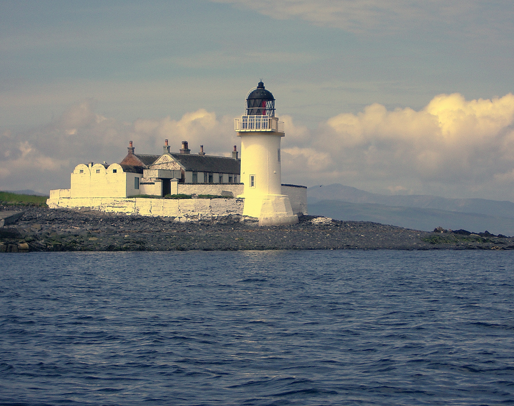
Fladda Lighthouse
Cullipool
Fladda Lighthouse is a small lighthouse on an islet in the Sound of Luing, visible from the village of Cullipool on the island of Luing in Argyll, Scotland. The islet belongs to the Slate Islands, a group shaped by centuries of slate quarrying, and lies about 1.8 km off the Luing shore. It makes a fine view from the coast, but the tower itself is not open to visitors. Where is Fladda Lighthouse? The light stands on a low, flat islet off Luing's eastern coast, in the channel where the Firth of Lorn narrows between the islands. The name comes from Old Norse and means "flat island". Don't confuse it with the other Fladda in the Treshnish Isles, or the islet of that name near Skye. This one is part of the Slate Islands, alongside Seil and Easdale. Who built it, and when? David and Thomas Stevenson, from the family of engineers behind many Scottish lighthouses, designed it, and it was completed in 1860. The Northern Lighthouse Board bought the island first so it could place a navigation light for ships threading the narrow passages between the islands. Two keepers manned the station. Luing boatmen carried supplies and relief crews, and drinking water had to be brought across from Luing. The MacLachlan family of Cullipool served the light, and the family still runs the Cuan ferry today. What changed after 1956? Fladda was automated in 1956 and the keepers left. It was only the second major NLB lighthouse to be automated. The lamp ran on gas and was controlled from Edinburgh, then switched to solar power in 1989. It now ranks as a minor light. The keepers' cottages were sold and are in private hands. What can you see, and where? From the Luing shore, especially Cullipool: the lighthouse set against the channel and the islands beyond. Morning or early evening light with good visibility works best. At the Atlantic Islands Centre in Cullipool: the lighthouse's original optic, plus displays on the keepers and island life. The centre opened in May 2015. Cullipool itself: a village of whitewashed quarry workers' cottages, a good base for a walk on Luing. How do you get there? Take the short Cuan Sound ferry from Seil to Luing. Seil is linked to the mainland by a bridge, reached by road from the Oban area. From the ferry landing it is a few kilometres across Luing to Cullipool. Frequently asked questions Can you visit Fladda Lighthouse? No. The tower is closed to the public and the keepers' cottages are private. You view the light from the shore of Luing. Where is the best place to see it? Around Cullipool, directly opposite the islet at roughly 1.8 km. Is the lighthouse still working? Yes. It is an active light managed by the Northern Lighthouse Board and solar-powered since 1989. Where can I see the original lamp? At the Atlantic Islands Centre in Cullipool, which also has material on the keepers and the lighthouse's history.
-
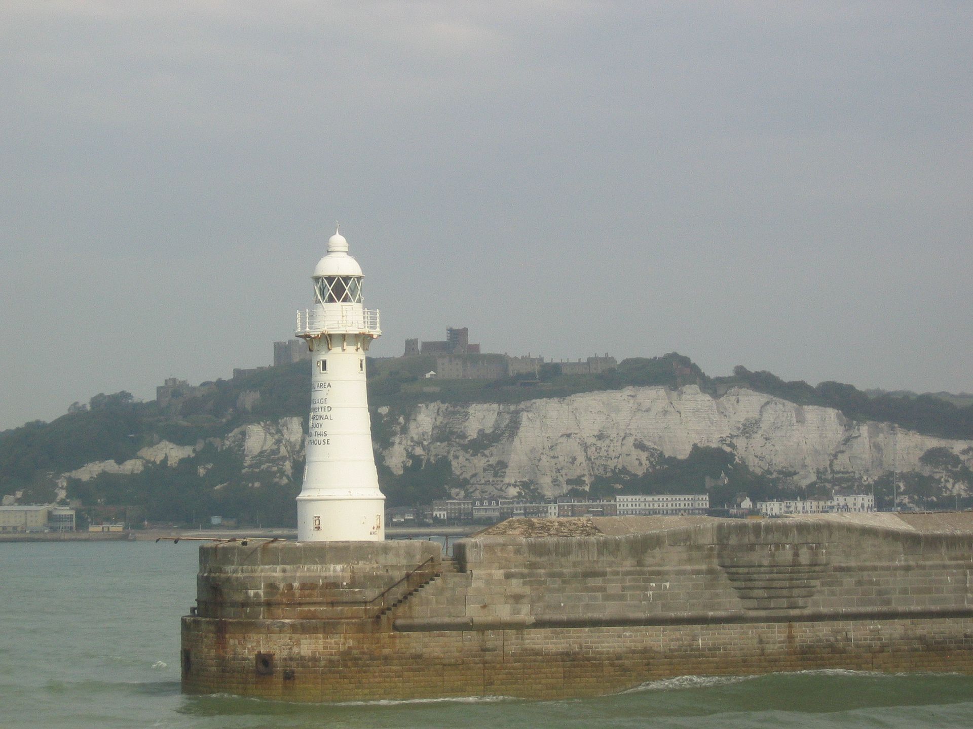
Dover Breakwater West End light
Dover
Dover Breakwater West End light is a white cast-iron lighthouse on the western tip of the Southern Breakwater in Dover Harbour, Kent. Heritage records also call it the West Head Light. Together with the light on Admiralty Pier, it marks the western entrance to the port used by cross-Channel ferries. What is this lighthouse? It belongs to the Southern Breakwater, built between 1898 and 1909 to a design by Coode, Son and Mathews. The breakwater stands as a free-standing island about 1.3 km long, between Admiralty Pier and the Eastern Arm. It is described as the first artificial harbour constructed in the 20th century. Its concrete blocks weigh 26 to 42 tons each and are faced with granite above the waterline. The tower has a cylindrical base and four stages, tapering from the second one upward. A walkway on curved brackets circles the domed lantern. The listing gives no height for it, so none is stated here. What else stands at the west end? Around the lighthouse sits a small defensive battery: flat-roofed barracks and magazines topped by concrete gun emplacements. The guns are gone, but early 20th-century fittings and some wall murals remain. The breakwater's second light, the Knuckle Light, stands about three quarters of the way along, where the east end begins to curve north. Why does it matter? The breakwater sheltered warships in both World Wars, including during the 1940 Dunkirk evacuation. It was listed Grade II on 16 December 2009 together with the Knuckle and West Head lighthouses (Historic England entry 1393607). How can you see it? The breakwater is part of the working port run by Dover Harbour Board, so it is not a visitor attraction with open access. The best views are from the water, on a ferry entering or leaving the harbour, or from the shore near the port looking west. Coordinates: 51.11315 N, 1.32997 E. Frequently asked questions Can I walk out to the lighthouse? No. The breakwater lies inside the port zone and the light is a navigation aid, not a museum. Is the lighthouse a listed structure? Yes. It forms part of the Southern Breakwater, listed Grade II in 2009. How is it different from the Admiralty Pier light? Admiralty Pier is a separate structure with its own lighthouse dating from 1908. The West End light stands at the western end of the detached outer breakwater. When is the best time to see it? In daylight on a ferry crossing, when the white cast-iron body is clearly visible. After dark its navigation light picks it out.
-
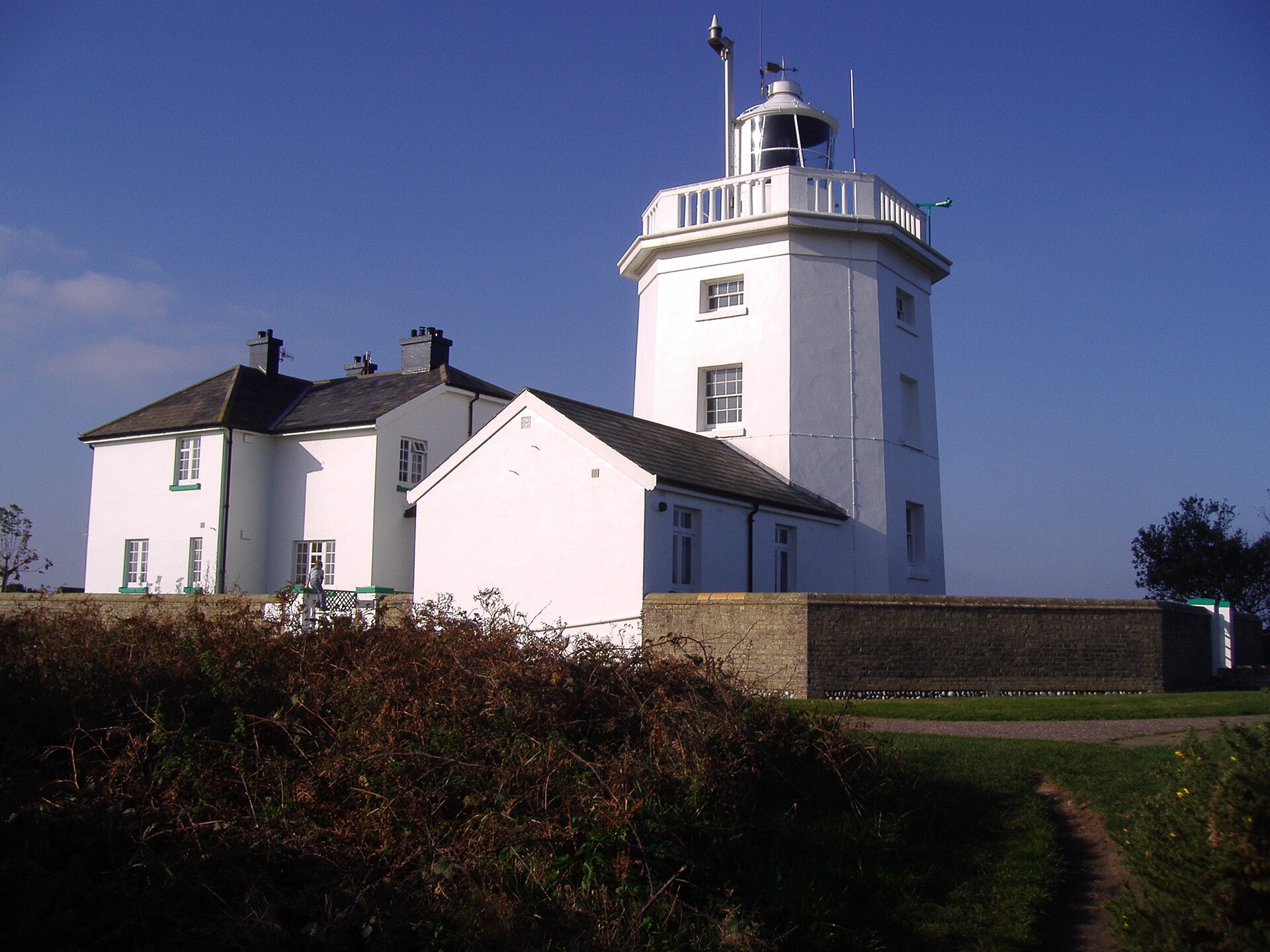
Cromer Lighthouse
North Norfolk
Cromer Lighthouse sits on high ground just south-east of the centre of Cromer, on the North Norfolk coast in eastern England. It is a working light run by Trinity House, and its octagonal tower is one of the best-known landmarks along this stretch of shoreline. What is the story behind it? The present tower went up in 1833, built by Trinity House on the Cromer Ridge, the line of low hills running along the coast. It replaced a brick lighthouse from 1719, put up by Edward Browne of Ipswich, which was lost to cliff erosion. Earlier still, a 1669 patent produced a tower at Cromer that was never properly lit because its backer could not afford the fuel; it still appeared on charts as a daymark. How tall is it? The tower itself is around 18 m (59 ft), but because it stands on elevated ground the light sits roughly 84 m (276 ft) above sea level. That height is why the lighthouse is visible from far out to sea and from many of the roads around the town. Sources give slightly differing figures, so treat these as approximate. How has it changed over time? The lighthouse was converted to electric power in 1958 and automated in June 1990, so no keepers live there today. According to Wikipedia, the drum lens in use from 1958 was replaced by an LED light source in 2025. Is it a listed building? Yes. Historic England lists Cromer Lighthouse at Grade II (list entry 1171781), a status it has held since 21 January 1977. The listed address is Overstrand Road, Cromer. Getting there and when to go The lighthouse stands on the edge of Cromer along the road towards Overstrand, a short trip from the pier and the town centre. It pairs well with a walk along the clifftop coast. Because it is an operational station, interior access is not a regular attraction, so check Trinity House for current information before you travel. The tower is easy to see and photograph from outside in any season, with clear skies giving the best shots. Frequently asked questions When was the current Cromer Lighthouse built? In 1833, by Trinity House. Who runs it? Trinity House, the authority responsible for aids to navigation at sea. Is it a protected building? Yes, it is Grade II listed by Historic England, and has been since 1977. Does a keeper live there? No. The station has been automatic since 1990. Why did the earlier lighthouse disappear? It fell victim to cliff erosion, a continuing problem on the Norfolk coast.
-
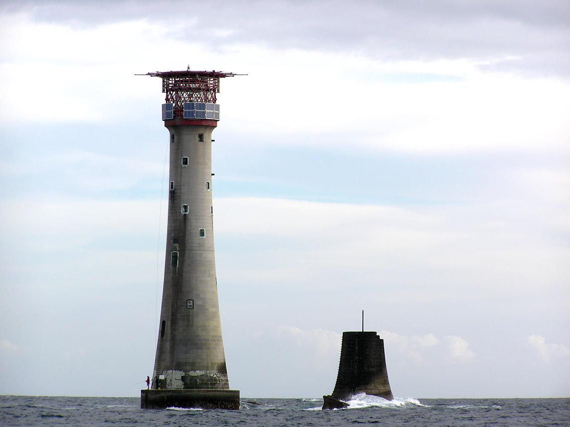
Eddystone Lighthouse
Eddystone Lighthouse sits on the Eddystone Rocks, a reef about 14 miles out to sea from Rame Head, off Plymouth on the Devon and Cornwall coast of England. The tower you see today is the fourth to stand there, and it still works as a navigation light on one of the most hazardous stretches of the English Channel. Why were four towers built on one reef? The rocks lie barely below the surface on the approach to Plymouth, and Atlantic swell hammers them constantly. Storms and fire took out the early structures, so each new tower was a response to the failures of the one before. What were the four towers? Winstanley's tower. Henry Winstanley built the first one, a wooden structure first lit on 14 November 1698. A storm destroyed it in 1703, and its builder died in the collapse. Rudyerd's tower. John Rudyerd raised the second, also timber, completed around 1709. A fire that began in the lantern consumed it in 1755. Smeaton's tower. Engineer John Smeaton designed the third in stone. Its profile and interlocking blocks shaped lighthouse design well beyond Devon, and it marks an important step in the use of concrete in construction. Douglass's tower. James Douglass designed the current lighthouse, drawing on Smeaton's methods as developed by Robert Stevenson. It was first lit in 1882. Who runs it today? Trinity House, the UK's lighthouse authority, operates the light. It was automated in 1982, the first Trinity House lighthouse converted to unmanned operation. Visitors cannot land on the reef, but on a clear day the tower is visible from the shore. What can you see in Plymouth? After the new lighthouse replaced it, the stone part of Smeaton's tower was taken down and rebuilt on Plymouth Hoe, where it now serves as a memorial and visitor attraction. It is the best place to learn about Eddystone up close. The climb is around 93 steps with steep ladders and low ceilings, so access for visitors with limited mobility is very restricted. From the top, on a clear day, you can pick out the present Eddystone lighthouse on the horizon. Recent listings give adult entry at about £8 (£7 booked online), with last entry at 4.30pm. When should you visit? Smeaton's Tower opens seasonally. In autumn 2026 it is open on weekends until 25 October, then Tuesday to Sunday from 27 October to 1 November, and closed after that. In the main season, hours are typically 10am to 5pm, Tuesday to Sunday. Check the current schedule with The Box Plymouth before you go. Calm, clear days give the best view of the horizon. Frequently asked questions Can you visit the lighthouse on the reef itself? No. It is an automated working aid to navigation run by Trinity House. Visitors view it from afar or tour the rebuilt Smeaton's Tower in Plymouth. Which tower is on the rocks now? The fourth, designed by James Douglass and first lit in 1882. Where is Smeaton's Tower? On Plymouth Hoe in the city of Plymouth, where it was re-erected after the new lighthouse took over. Is the lighthouse staffed? No. It has operated automatically since 1982.
-
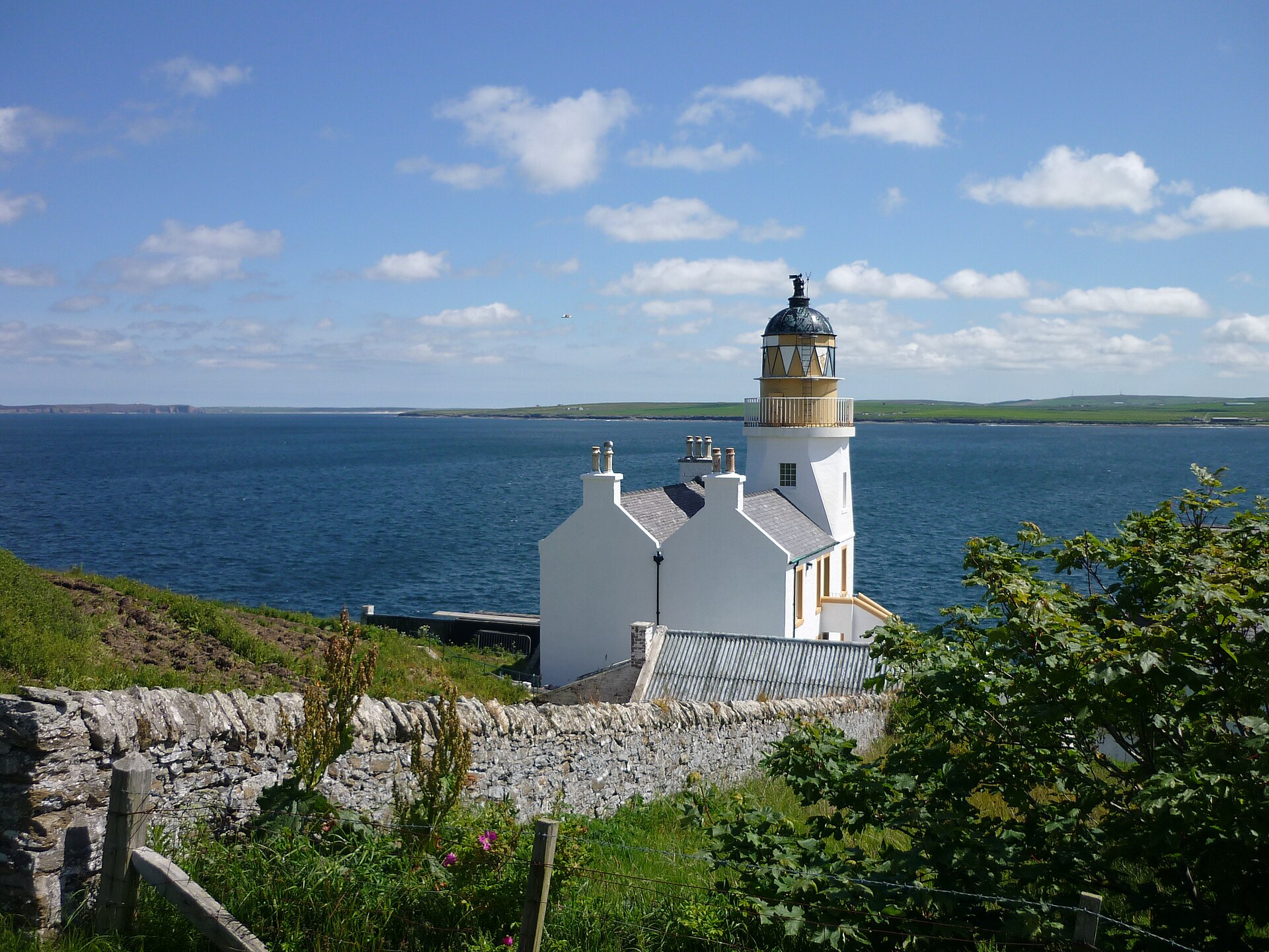
Holburn Head Lighthouse
Scrabster
Holburn Head Lighthouse (also spelled Holborn Head) sits on a rocky headland beside the harbour village of Scrabster, near Thurso in Caithness on Scotland's north coast. The headland closes off the western side of Thurso Bay and faces the open Atlantic and the Pentland Firth. Who built it, and what is unusual about it? David and Thomas Stevenson, members of the family that engineered so many of Scotland's lighthouses, designed it. The Board of Trade gave approval in 1859, but worries about cost held up work until 1861. The light first shone in September 1862, although the Highland Historic Environment Record gives 1863. The tower is about 17 metres high and cost 3,900 pounds, a bill the Board of Trade queried. The design is a "school house" type: the tower is built into the keeper's house rather than standing alone. The result looks more like a sturdy home with a tower attached than a classic freestanding column. What happened over the years? The light operated from 1862 until 2003. It was automated in 1988 and the keepers left; in 2003 it was judged unnecessary and permanently withdrawn. Canmore records that German aircraft bombed the site during the Second World War without damaging the buildings. Since 28 November 1984 it has been a Category B listed building (Historic Environment Scotland ref. LB14952). The listing covers the lighthouse and keeper's house; the later keeper's house to the southwest is excluded. Can you go inside? No. The former keepers' flats and tower have been converted into a private home, renovated in line with the Category B status. You view the lighthouse from outside, and the headland itself makes a pleasant short outing with views over the bay and sea. How do you get there? The lighthouse is by Scrabster, the port just west of Thurso where the Orkney ferries sail from. It is a short drive from Thurso, so it fits easily into a wait for a ferry or a stop on the North Coast 500. Coordinates are roughly 58.615 N, 3.54 W. When should you visit? The headland is exposed, so weather shapes the visit. A clear day gives the best views over Thurso Bay and the Pentland Firth. In strong wind, common on this coast, dress warmly and keep clear of the cliff edge. Summer days are long, so there is good light for photos well into the evening. Frequently asked questions Who designed Holburn Head Lighthouse? David and Thomas Stevenson, Scottish lighthouse engineers. Is the light still working? No. It was automated in 1988 and withdrawn from service in 2003. Can I tour the inside? No, the building is a private residence. You can see it from the surrounding headland. Why do I see two spellings? Sources use both Holburn Head and Holborn Head; they refer to the same site by Scrabster.
-
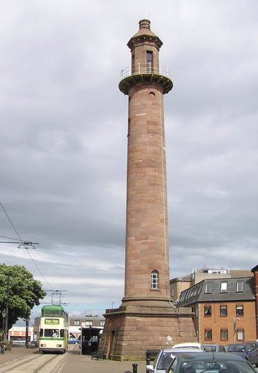
Pharos Lighthouse
Fleetwood
Pharos Lighthouse in Fleetwood is a tall red sandstone tower rising straight out of the town's streets in Lancashire, England. It first shone in 1840 and, together with a shorter sibling on the shore, guided ships into the mouth of the River Wyre. It remains the best-known landmark in town. What is the Pharos Lighthouse? Historic England lists it as the Upper Lighthouse, or Pharos, on Pharos Place. Unusually for a working light, it stands among ordinary houses rather than on a headland. The tower is roughly 28 metres tall, with a cylindrical shaft and an octagonal lantern section on top. It has been Grade II listed since 1978 (list entry 1072397). Who designed it, and why? Fleetwood was laid out in the 1830s as a planned port and resort. The lighthouse is credited to Decimus Burton, the town's architect, with Captain H. M. Denham named by some sources as co-designer for the navigational side. Construction ran from 1836 to 1840, and both lights were first lit on 1 December 1840. How is it different from the Lower Lighthouse? The Pharos was built as one half of a pair. The Lower Lighthouse, also called the Beach Lighthouse, stands on the seafront and is about 13 metres high. Mariners who saw the two lights line up knew they were on the safe channel. So the tall tower among the houses is the Pharos; the short one by the sea is the Lower Lighthouse. What will you see? The tower is a sight to photograph from the street. The warm red stone, the slender profile and the contrast with the surrounding terraces make it striking, particularly in afternoon light. The interior is generally not open to visitors. How do you get there? It sits in central Fleetwood, a few minutes on foot from the main streets. The Blackpool tramway runs to Fleetwood, which makes the trip easy from the resort. Pair the visit with a walk to the promenade, the Lower Lighthouse and the harbour. Frequently asked questions Can you go inside the Pharos Lighthouse? Usually not. It is viewed from outside and only rarely opened. How tall is it? About 28 metres; sources quote figures between 27 and 29 metres. Is it the same as the Lower Lighthouse? No. The Lower Lighthouse is on the beach and is much shorter; the two worked as a pair of leading lights. Is it a listed building? Yes, it has been Grade II listed since 1978.
-

Dunollie Lighthouse
Oban
Dunollie Lighthouse is a small stone lighthouse on the north side of Oban Bay, in Argyll and Bute on Scotland's west coast. It sits on the shore by Ganavan Road, roughly 400 metres south of Dunollie Castle, and marks the northern approach to the bay and the Sound of Kerrera. What is Dunollie Lighthouse? It is one of the smallest lighthouses you will find in Scotland. The round tower stands about 6 metres tall and is built of dark whinstone, which blends with the rocky shoreline. With its slightly sloping walls and rough masonry, it looks more like a little watchtower than a classic lighthouse. It is a working aid to navigation, not a castle or a museum. What is its history? By the late 1800s Oban harbour was busy with trade and pleasure boats, and the northern entrance needed better marking. The Northern Lighthouse Board turned down a request in 1886 but suggested a light near Dunollie Castle, to be run by the local harbour authority. The tower went up in 1891–1892 under engineers David A. and Charles Stevenson, members of the famous Scottish lighthouse-building family. It first shone on 13 February 1892, fuelled by gas from Oban's town supply. Collimating screens were added in 1979 so sailors can tell the coloured sectors apart, and solar panels power the light today. Why is it a listed building? Historic Environment Scotland gave the lighthouse Category C listed status in December 2020. The listing points to the rustic whinstone masonry, uncommon among Stevenson lights, and to the rectangular lantern panes, which were unusual for the Board's lights. Only the tower is protected; the metal railings around it are not part of the listing. How does the light work now? It shows two flashes every 6 seconds, with white and red sectors and a range of about 8 nautical miles. Visit after dark if you want to see it shining across the bay. How do you get there, and what is nearby? The lighthouse is on the shore road north of Oban town centre, an easy walk along the waterfront. Close by are Dunollie Castle and Dunollie Museum, views across to the island of Kerrera, and the coastal route on towards Ganavan beach. Evening is the best time for photos, when the sun sets over the Sound of Kerrera. Frequently asked questions Can you go inside the lighthouse? No. It is an operating navigation light and is viewed from the outside, from the shore. Is there an entrance fee? No. You can see it from the public shore road, free of charge. Is the lighthouse part of Dunollie Castle? No. It is a separate structure about 400 metres from the castle. The castle and museum are visited separately. When was it built? Construction took place in 1891–1892, and the light was first lit on 13 February 1892.
-
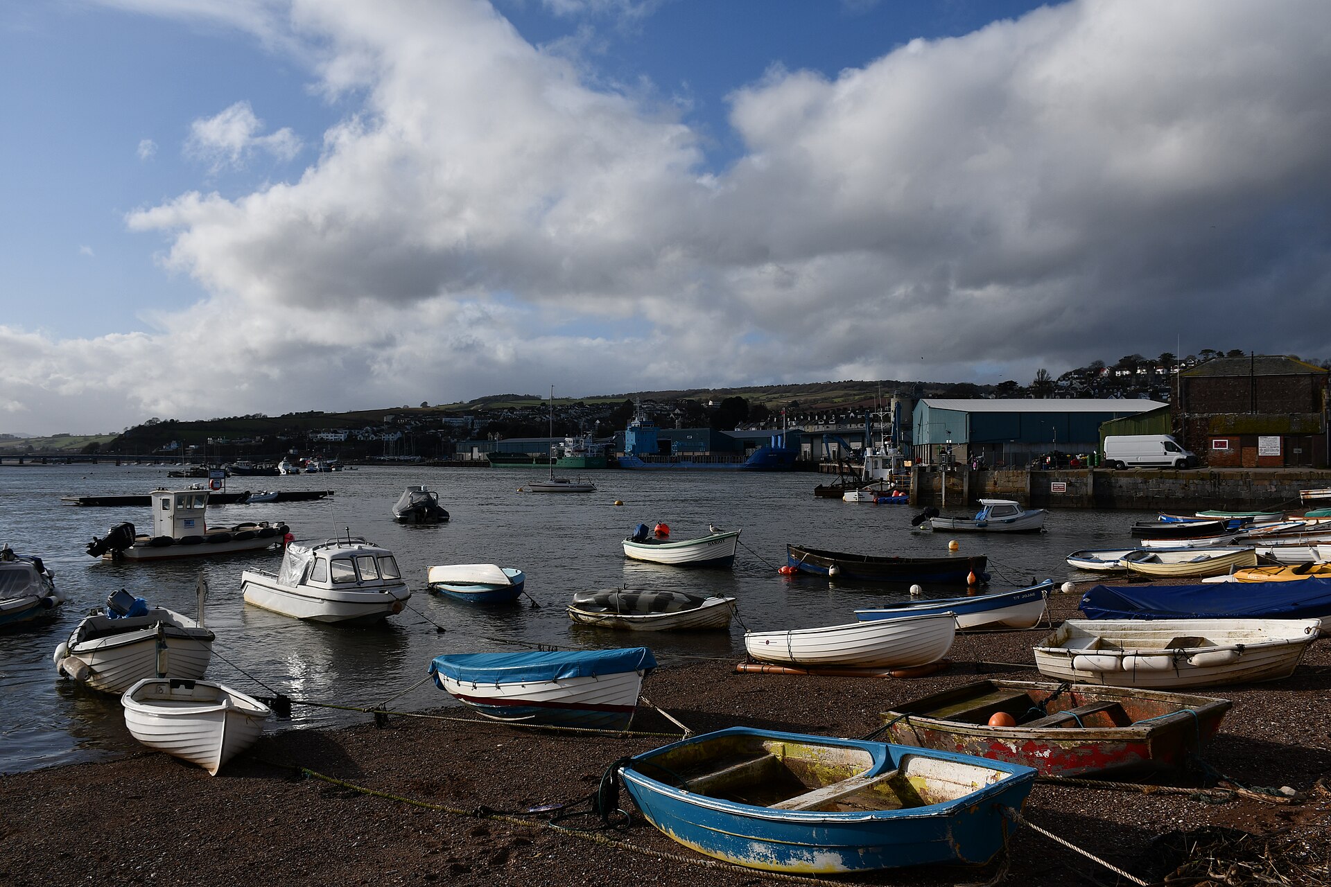
New Quay
Teignbridge
New Quay in Teignmouth (Teignbridge district, Devon, England) is a working-heritage quay dating from 1820, built to get Dartmoor granite onto ships bound for London. Today it is a quiet stretch of waterfront by the Teign estuary and a Grade II listed structure. What is New Quay in Teignmouth? It is a stone quay off New Quay Street, close to where the River Teign meets the English Channel. Historic England includes it on the National Heritage List for England at Grade II, the category for buildings and structures of special interest. Do not confuse it with other places of the same name: New Quay in Ceredigion is a Welsh seaside resort, and a different, abandoned mining hamlet called New Quay sits on the River Tamar in west Devon. Why was it built? The quay went up in 1820 for George Templer of Stover, a landowner with deep ties to the Teign valley. Its builders used Haytor granite from Dartmoor and limestone from the Plymouth area. Stone came down to the estuary and left by sea for London, where granite was wanted for the new London Bridge. A mid-19th-century county directory backs up the wider picture: Teignmouth exported Haytor granite and ball clay from around Kingsteignton, and a large quay had been built in 1820 to handle such heavy cargo. The listing describes a structure roughly 40 metres wide, projecting about 50 metres into the water. What can you see there? The solid stone quay itself, a reminder of the scale of the bulk-cargo trade. The New Quay Inn and its attached rear warehouse, also Grade II listed and of about the same date. Views across the Teign estuary, with boats and harbour activity. This is part of the town rather than a ticketed attraction, so you see it from outside on a waterfront stroll. The historic buildings have no visitor interiors; the inn simply operates as a pub. How do you get there? Teignmouth has a station on the Devon coast railway line, in the town centre a short walk from the quay. By car, approach from Exeter via Dawlish or from Newton Abbot. Parking in town is paid and the rules change, so check the signs on arrival. The coordinates are about 50.544 N, 3.499 W. When should you visit? The quay can be viewed all year. Late spring to early autumn is the most comfortable time, with long days for walking around the harbour and nearby beach. In winter it is windier, but the town stays open and pubs and cafes keep trading. Frequently asked questions Is there an entrance fee? No. It is a public area of the town waterfront. Only parking and local services cost money. Is this the same as New Quay in Wales? No. The Welsh New Quay is in Ceredigion on Cardigan Bay. This quay is in Teignmouth, Devon. What was the quay used for? Loading Haytor granite onto ships. Dartmoor stone travelled by sea to London, where it was used on the bridge works. Can I go inside the pub and warehouse? The New Quay Inn is an ordinary pub and keeps its own opening hours. The warehouse behind it is part of the listed group and is best appreciated from outside.
-

Smalls Lighthouse
Marloes
Smalls Lighthouse is the most remote lighthouse run by Trinity House, standing on the Smalls reef roughly 27 km (about 20 nautical miles) off the Pembrokeshire coast in Wales. Cadw lists the tower at Grade II, and it is recognised as a National Monument of Wales. It is officially recorded under the community of Marloes and St Brides, the nearest mainland parish. Can you actually get there? Not like an ordinary attraction. The tower rises from open sea with no beach, no visitor jetty and no public tours. It remains a working aid to navigation operated by Trinity House. From Marloes or Martin's Haven you cannot count on spotting it: the distance is great and visibility depends on weather and clear air. We found no confirmed scheduled boat trips that reach the rock. The Pembrokeshire Coast National Park describes the surrounding waters as a place for wildlife trips, sailing and diving, without naming operators. If you want a close look, ask local boat operators about current options and sea conditions. How was it built? The first lighthouse was designed by Henry Whiteside, a Liverpool maker of musical instruments. His timber house on legs was trial-assembled at Solva in the winter of 1775-76 and then shipped to the reef. It stood for about 80 years, and life for its keepers was notoriously hard. The present stone tower was built under engineer James Walker, with the first stone laid in 1858. It was first lit in 1861 and its design follows Smeaton's celebrated Eddystone tower. A helideck was added above the lantern in 1978, and the station was automated in 1987, so nobody lives on the rock today. What is its story? The Smalls gained a grim reputation in the early 1800s. According to accounts of the time, one of the two keepers died during a storm, and the survivor, fearing he would be blamed, kept the body close for a long stretch. The episode is often cited as a reason lighthouses were staffed with more keepers. When is the best time to look out for it? Pick a day with crisp visibility, such as after rain when the horizon is sharp, and watch from the clifftops near Marloes and Martin's Haven. Binoculars or a small telescope help a great deal. An 1870 Admiralty description gave the light's range in clear weather as about 15 miles. Frequently asked questions Can I visit the inside of Smalls Lighthouse? No. It is an active Trinity House station on an offshore reef and is closed to tourism. Where is it? On the Smalls reef about 27 km off Pembrokeshire, west of Skomer and near Grassholm. When was it built? The current stone tower was completed and lit in 1861. The earlier timber lighthouse served for roughly 80 years. Is it automated? Yes, since 1987. A helideck has topped the lantern since 1978.
-
Hyskeir Lighthouse
Hyskeir Lighthouse (Gaelic Oigh-sgeir) rises from a tiny uninhabited island in the Inner Hebrides, in the Scottish Highlands council area. Standing 39 metres tall, the white tower has marked the southern approach to the Minch since 1904. Where is Hyskeir? The island sits in open sea about 10 km south-west of Canna and roughly 14 km west of Rùm, at around 56.97 N, 6.68 W. Nobody lives here permanently, and the lighthouse is a working navigation station rather than a standard sightseeing stop. It appeals to lighthouse enthusiasts, sailors and anyone exploring the Small Isles by boat, and it is best seen from the water or from neighbouring islands such as Canna. Why was it built? The light warns shipping of three hazards: the Mills Rocks, Canna, and Hyskeir itself. Engineers David Alan Stevenson and Charles Alexander Stevenson, part of the celebrated family of Scottish lighthouse designers, drew up the plans. The Oban firm D & J MacDougall carried out the construction, and the light was first shown in 1904. What makes it special? Hyskeir is among the few Scottish lighthouses that still hold their original hyperradial lens, an exceptionally large Fresnel-type optic. The light's listed intensity is about 788,000 candela. Electric power arrived in 1959. What was life like for the keepers? Keepers' families lived in Oban, where a shore station was built in 1904, while the men served month-long duties on the rock. From the 1970s relief crews were flown in by helicopter from a purpose-built pad, though heavy supplies still arrived by ship. During the winter of 1980 storms halted oil deliveries, and the station was down to roughly two days of fuel before a delivery got through. Visitors over the years included the Moderator of the Church of Scotland in 1974 and John McCarthy and Sandi Toksvig, who stopped by in 1994 while making a book and documentary. Former keeper Peter Hill wrote about his time on the station in his 2003 memoir Stargazing. Who runs it today? The Northern Lighthouse Board operates the light. The keepers left in March 1997 when the station was automated, making it one of the last Scottish lighthouses to lose its resident crew. The lamp is now monitored remotely from the Board's headquarters in Edinburgh. When is the best time to go? Late spring to early autumn gives calmer seas and long daylight for boat trips around the Small Isles. Conditions in the Minch change quickly, so any crossing depends on wind and swell. Frequently asked questions Can you visit Hyskeir Lighthouse? It is an active Northern Lighthouse Board site on an uninhabited island. Most people view it from the sea, and any landing needs arrangements with a boat operator in advance. Who built Hyskeir Lighthouse? It was designed by David Alan and Charles Alexander Stevenson and built by D & J MacDougall of Oban in 1904. Does anyone still live at the lighthouse? No. It was automated in 1997 and is monitored remotely from Edinburgh. How tall is the tower? The tower is 39 metres (128 ft) high and warns ships of the Mills Rocks, Canna and Hyskeir itself.
-
St Catherine's Point light
Fowey
St Catherine's Point light is a small lighthouse on the headland guarding the mouth of the River Fowey in Cornwall, beside the town of Fowey. It is not the famous St Catherine's Lighthouse on the Isle of Wight; this one sits on Cornwall's south coast, at the harbour entrance. What is this lighthouse? The little tower stands at the cliff edge where the estuary meets the sea and marks the way into Fowey. It was built in 1904 and first lit in January 1905, and it ran unwatched from the start. The light was electrified around 1946. In 2002 the Fowey Harbour Commissioners bought out the lease and they still look after it. The point lies at roughly 50.327 N, 4.647 W. It works as a navigation aid rather than a visitor attraction: you admire it from outside, best seen from the water or the coast path. What else is on the headland? The same promontory carries St Catherine's Castle, a compact 16th-century artillery fort run by English Heritage. Historic England dates it to 1538–1540 under Henry VIII, while the Fowey Harbour Heritage Society gives 1538–1542. A prominent local man paid for and oversaw the work, and sources name Thomas Treffry of Place. Its purpose was to shield a wealthy trading port from seaborne attack at a time when French and Spanish invasion was feared. Later centuries added their own layers: guns were mounted here during the Dutch wars of the 17th century, the Napoleonic wars, the Crimean War (a rebuild in 1855–58 gave it the name Fowey Battery) and again in June 1940. The site is protected as a Grade II* monument and the ruins are free to explore. How do you get there? From the centre of Fowey, follow the coastal path towards Readymoney Cove and on to the headland. The walk is short but involves uneven ground and steps, so wear proper footwear. Parking in Fowey fills up in summer, so it is easier to leave the car on the edge of town and walk. A passenger ferry also links Fowey with Polruan across the river. When should you visit? Spring and early autumn are best, with fewer people and a clear view over the harbour mouth. Summer afternoons are busy, though the evening light over the bay makes up for it. In strong southerly winds the cliff top is exposed and slippery. Frequently asked questions Can you go inside the lighthouse? No. It is a working aid run by the harbour authority and is viewed from outside only. Is this the same as St Catherine's Lighthouse on the Isle of Wight? No. The names match, but the two are in different parts of England. This one is in Cornwall, by Fowey. Does St Catherine's Castle charge admission? It is in English Heritage's care and open to wander freely; check their website for current access before you go. How long should I allow? About an hour covers the walk out, the castle and the lighthouse. Add more if you continue along the coast path, which can fill half a day.
-
Gairlochy Lighthouse
Gairlochy Lighthouse is a small signal lighthouse in Gairlochy, Highland, Scotland, at the south-western end of Loch Lochy. It stands where boats leave the loch and enter the Caledonian Canal. It is not a tall coastal tower but a piece of working canal infrastructure, protected together with the neighbouring locks. What is the lighthouse at Gairlochy? The structure marks the canal entrance from Loch Lochy. Aerial photographs held by Canmore show it in the foreground beside the locks, with the Mucomir Cut running alongside, an artificial channel linking the loch to the River Lochy. The Highland Historic Environment Record also describes it as a signal lamp at the southern end of the loch. For a skipper, it is the cue that the locks and the canal are close. What is the history of the site? Thomas Telford designed the Caledonian Canal, and construction ran from 1803 to 1822. The oldest structure at Gairlochy is the regulating lock, finished in 1813. It could not handle the volume of water leaving Loch Lochy, so a second, western lock was added in 1844. The River Lochy once flowed into the loch along the stretch now occupied by the canal. The Mucomir Cut was dug to separate the two, but it proved inadequate, and in 1834 the river burst its banks and flooded the lock. Today the lighthouse, the locks and the signal lamp form a single Scheduled Monument, SM5294, listed by Historic Environment Scotland. What can you see here? two locks, east and west, with a swing bridge, the lighthouse at the loch end of the canal, the Mucomir Cut and views across Loch Lochy, boats working through the locks, especially in the sailing season. The Gairlochy locks lower the water to a level section that runs to the top lock at Banavie, where the famous Neptune's Staircase begins. How do you get there? Gairlochy lies north of Fort William, about 11 km by road. A car or bike is the easiest way to arrive, and the area sits on the Caledonian Canal route. A towpath leads along the canal between Banavie and Gairlochy and is popular with walkers and cyclists. When should you visit? Boat traffic peaks in summer, when the locks are busiest with leisure craft. The lighthouse and its surroundings can be viewed all year. Bring clothing for changeable weather, as Highland rain can arrive even in the main season. Frequently asked questions Is Gairlochy Lighthouse a conventional sea lighthouse? No. It is a small signalling structure marking the Caledonian Canal entrance from Loch Lochy, not a coastal light. Is the site protected? Yes. The lighthouse is part of Scheduled Monument SM5294 together with the locks and the signal lamp. When were the Gairlochy locks built? The regulating lock was completed in 1813 and the west lock in 1844. Which canal meets the loch here? The Caledonian Canal, designed by Thomas Telford and completed in 1822. It passes through Loch Lochy on its route between Scotland's east and west coasts.
-
Morecambe Pier Light
Morecambe
Morecambe Pier Light is a small octagonal sandstone lighthouse at the seaward end of the Stone Jetty in Morecambe, Lancashire. It sits on the town's seafront facing Morecambe Bay and is among the oldest structures on the waterfront. What is it, and why was it built? The railway company North Western Railway built the Stone Jetty in 1853 as a wharf and rail terminal for passengers and cargo. The lighthouse was added soon after the station building, on the sea side of the terminal. It is about 11 metres (36 ft) tall, made of rock-faced sandstone, with a white-painted cap and finial on the lantern. The design is credited to Thomas Stevenson, a member of the famous lighthouse-engineering family. What happened to the harbour? When the port of Heysham opened in 1904, traffic at Morecambe Harbour dropped quickly, and the railway yard here closed in 1932. In 1994-95 the jetty was refurbished and partly rebuilt as part of a wider seafront scheme that included sea defences. The former station building next to the lighthouse now works as a cafe. Is it a listed building? Yes. Historic England lists the former station building and the lighthouse together as one Grade II entry, dated 20 January 1993. The lighthouse has no separate entry of its own. What else is nearby? The jetty is a pleasant short walk towards the water. It carries artworks and pavement games from the Tern project, installed during the 1990s rebuild. Just along the promenade stands the Midland Hotel, an Art Deco landmark listed at Grade II*. From the end of the jetty you get wide views over the bay and, on clear days, towards the Lake District hills. How do I get there? The lighthouse is on the central Morecambe promenade, at roughly 54.0745 N, 2.8785 W. It is a few minutes' walk from Morecambe railway station. Access to the jetty is open, and the lighthouse itself is viewed from outside. When should I visit? Pick a clear day for the best views across the bay. Evenings often bring strong sunsets over Morecambe Bay, and the walk combines easily with a stroll along the prom. Bring a windproof layer, as the end of the jetty is exposed. Frequently asked questions Can I go inside the lighthouse? No, it is a listed structure seen from outside. The building beside it houses a cafe. Is there an entry fee for the Stone Jetty? No. The jetty is part of the public seafront and free to walk. Who designed the lighthouse? Thomas Stevenson is credited with the design. It dates from the 1850s, shortly after the station building. How long should I allow? Twenty to thirty minutes covers the jetty and the lighthouse. Add time for the Tern artworks and the Midland Hotel nearby.
-
Lundy Old Light
Torridge
Lundy Old Light is the former lighthouse on the island of Lundy in the Bristol Channel, part of the Torridge district of Devon. It crowns Beacon Hill, the highest ground on the island, and ranks among the oldest surviving lighthouses in this corner of England. Today it is a heritage site you can climb, and the old keepers' quarters double as holiday lets. Who built the Old Light, and when? Trinity House, the body in charge of lighting English waters, commissioned the tower. Its surveyor Daniel Asher Alexander drew up the design, and Lundy was among the last lighthouses he worked on. The tower went up in 1819 (a few sources say 1820), on foundations laid in 1787, with Joseph Nelson as builder. Why did it stop working? The site itself was the flaw. Beacon Hill is so high that cloud and fog regularly swallowed the lamp, leaving ships blind to it when they needed it most. A second, lower lantern was added in 1829 to work around the problem. The fix never fully solved it, and in 1897 two new lights, North Light and South Light, opened close to sea level. The Old Light was switched off for good. What can you see there? The tower is a scheduled monument (Historic England entry dating from 1970), while the adjoining keepers' buildings are Grade II* listed. The Landmark Trust, which runs the island with the National Trust, looks after the site. The lantern room was restored in 2012, and from it you get a 360-degree panorama over the whole island, its cliffs and the open channel. Do not confuse it with North Light or South Light, which are separate, later lighthouses from 1897 at either end of the island. The fog signal Battery, built in the early 1860s, is another separate site. How do you get to Lundy Old Light? Boats sail to the island from Ilfracombe on the north Devon coast. Day trips run several times a week, weather permitting. From the landing quay the walk uphill to the lighthouse takes around 45 minutes, so bring sturdy shoes and a windproof layer. When should you go? Pick a clear day. Poor visibility is exactly what doomed this lighthouse, and it will spoil the view too. Allow a full day for the crossing and the climb, and check sailing times and tower opening hours with the Landmark Trust beforehand. Frequently asked questions Is the Old Light still in use? No. It was retired in 1897 when North Light and South Light took over. Who designed it? Daniel Asher Alexander, surveyor to Trinity House. Can you go up the tower? Yes, it is open to visitors, and the lantern room looks out over the entire island. Can you stay overnight? Yes, the Landmark Trust lets the former keepers' quarters as holiday accommodation.
-
Fidra Lighthouse
Dirleton
Fidra Lighthouse is a white tower built in 1885 on the rocky island of Fidra in the Firth of Forth, off the East Lothian coast near Dirleton. The island sits about 4 km west-north-west of North Berwick and under 3 km north of Dirleton. You cannot walk onto it, but it is easy to see from Yellowcraig beach, roughly 300 m away across the water. Who built the lighthouse, and when? The light was first shown in 1885, to a design by Thomas and David A. Stevenson, members of the Scottish engineering family behind many of the country's coastal lights. The round tower stands about 17 m tall and is painted white, with the lamp at roughly 34 m above sea level. A two-storey block of keepers' cottages stands beside it. The Northern Lighthouse Board ran the station for decades, and keepers lived here with their families. Around 1970 the light went over to automatic, unmanned operation, which Canmore records as the Board's first such conversion. The buildings are protected as a Category C listed building in Scotland. Why does the island matter for wildlife? Fidra is now an RSPB Scotland nature reserve; the society bought the island, excluding the lighthouse buildings, in 1989. Its best-known residents are puffins. Scrub had choked the burrow entrances, and by the mid-1990s only about 400 burrows were occupied. After RSPB staff and volunteers cleared the vegetation, the count rose above 1,000. Other seabirds nest here too. Is this the island behind Treasure Island? Local tradition says the shape of Fidra inspired the map in Robert Louis Stevenson's Treasure Island. The writer came from the lighthouse-building family, and the island also appears in his novel Catriona. Unst in Shetland makes a rival claim, so treat it as a good story rather than established fact. How can you see Fidra? From the shore: Yellowcraig beach and its surrounding park give the best view, about 3 km from Dirleton off the A198. From North Berwick: the Scottish Seabird Centre has telescopes and cameras trained on the puffin colony. From the water: boat trips on the Firth of Forth bring you close without landing. When: puffins are on the island in spring and summer, roughly April to early August. The island is not open to visitors for landing, since it is a breeding reserve with lighthouse property on it. Frequently asked questions Can I visit Fidra island? Not as an ordinary visitor. It is an RSPB reserve and landing needs arrangement with the island's managers. View it from Yellowcraig or from a boat. When was Fidra Lighthouse built? The light was first shown in 1885, designed by Thomas and David A. Stevenson. Will I see puffins? Yes, from spring to early summer. Bring binoculars for the shore view, or use the equipment at the Seabird Centre in North Berwick. How do I get to Yellowcraig? Drive from Dirleton along the signed road to the beach (about 3 km), then walk a short way through the dunes to the shore.
-
Killingholme South Low Lighthouse
Killingholme South Low Lighthouse stands in South Killingholme, North Lincolnshire, on the south bank of the Humber Estuary in eastern England. The four-storey brick tower, about 15 metres tall, belongs to a set of leading lights that once steered ships through the lower reaches of the river. What is this lighthouse? It dates from 1836, when local builder William Hearfield was contracted to raise two towers roughly 620 feet (about 190 m) apart to a design credited to Francis Dales. The walls are brick and cement, rendered inside and out. This was the original Low Light; it only became "South Low" after a new low light, North Low, went up at Killingholme in 1852. Historic England listed it at Grade II on 17 October 1985 (list entry 1215093). How did leading lights work? Humber pilots relied on pairs of lights, one high and one low. Seen from the channel, the two lights lined up vertically when a ship was on the correct course between the sandbanks. South Low worked together with the nearby Killingholme High tower, rebuilt in 1876-77 and standing around 30 metres. Do not confuse it with Killingholme North Low, a separate tower with its own listing (1103707). What will you see? This is a look-from-the-outside stop: a slim whitewashed tower rising from flat farmland and industrial land, with port facilities and refinery-era development close by. There is no interior visit. Low sun gives the best photos, when the brick and render stand out against the sky. How do you get there? South Killingholme lies near Immingham and Grimsby, about 20 km from Grimsby and not far from the Humber Bridge. Driving is the practical option, as local bus services are sparse. The tower sits at 53.6465 N, 0.2162 W. It makes sense to combine it with a look at the other two Killingholme towers. When should you visit? The tower is visible all year. Late spring and summer offer long days and dry lanes for a photo stop. The landscape is flat and exposed, so bring a windproof layer even in warm months. Frequently asked questions Can I go inside the lighthouse? No. It is a heritage landmark viewed from outside. How old is it? It was built in 1836, so it is nearly 190 years old. How do South Low, North Low and High differ? South Low is the original 1836 low light; North Low followed in 1852; High is the taller tower rebuilt in 1876-77. Each has its own listing. Where is South Killingholme? In North Lincolnshire on the Humber's south shore; the village had about 1,100 residents at the 2011 census.
-
Corsewall Lighthouse
Kirkcolm
Corsewall Lighthouse sits on Corsewall Point, about 6 km north-west of the village of Kirkcolm in Dumfries and Galloway, south-west Scotland. Designed by Robert Stevenson, it ranks among the early Stevenson lights, and the old keepers' complex now operates as a hotel with a restaurant, facing the Irish Sea. Who built it, and when? Construction ran from about 1815 to 1817 for the Northern Lighthouse Board, the body that marks Scotland's coast. The engineer was Robert Stevenson, grandfather of the author Robert Louis Stevenson. Sources disagree on the exact first-lighting year: 1817 is the usual answer, though some records say 1816. The tower stands roughly 28 metres (92 ft) tall, with the keepers' houses grouped beside it inside an enclosure wall. The tower, the keepers' houses and the boundary walls are together protected as a Category A listed building, the highest tier in Scotland (reference LB9923, listed 1972). The site also has a Canmore record. What is its history? People tended the light for more than 170 years. Local accounts say the first keeper lost his job after the lamp's turning mechanism stopped while he slept on duty. The light was automated in 1994 and is now monitored remotely from the Board's Edinburgh headquarters. The accommodation was sold into private hands in 1995 and later became a hotel. What will you see? The tower and the keepers' buildings - a white lighthouse with its original cottages, forming a compact and well-preserved group. Sea views - the Rhins of Galloway peninsula points towards Northern Ireland. In clear weather you can make out the far coast, and ferries pass on the Stranraer-Belfast route. The headland - open, windswept ground that suits a short walk and seabird watching. How do you get there? Corsewall Point lies at the northern tip of the Rhins peninsula, about 18 km from Stranraer. Driving is the practical option, along the coast road through Kirkcolm; public transport in this corner of Scotland is sparse. Stranraer has a bus station and is the hub for travellers arriving on ferries from Northern Ireland. When should you visit? Late spring to early autumn gives longer days and better visibility, and sunsets over the Irish Sea can be striking. Winter brings strong wind and changeable weather, so dress in layers. Frequently asked questions Can you climb the lighthouse? The tower is working navigation infrastructure rather than a standard climb-to-the-top attraction. You can view it from the grounds by the hotel; check with the hotel about access. Can you stay overnight? Yes. The former keepers' houses are now the Corsewall Lighthouse Hotel, offering rooms and meals. Is the light still in use? Yes. It has shone since 1817 (or slightly earlier by some accounts) and has been automated and remotely monitored since 1994. Can you see Northern Ireland from here? On a clear day, yes. It is one of the places in Scotland where the opposite shore is visible across the sea.
-
Killingholme High Lighthouse
Killingholme High Lighthouse is a tall brick tower in South Killingholme, North Lincolnshire, on the south bank of the Humber estuary in eastern England. It worked as one half of a leading-light pair with the nearby Low lighthouse, helping ships hold a safe line through the estuary's channel. The tower is a Grade II listed building. What is Killingholme High Lighthouse? It is a range light: two lights placed in a line so a pilot who saw one directly above the other knew the ship was on the right course. The High light stands further inland, the Low light closer to the water. In the 19th century this stretch of the Humber had three such towers, High plus the North Low and South Low lights. The first light here was established in 1831. What does the tower look like? The lighthouse is roughly 30 metres tall and has six storeys. It is a round, tapering brick tower with a rendered and painted finish, capped by a ribbed dome. A plaque on the north side records its enlargement and rebuilding in 1876–77 for Trinity House of Kingston upon Hull, which gave the tower the form you see today. Why visit? It shows how shipping on the Humber, one of Britain's busiest waterways, was guided before modern electronics. It is a well-preserved example of Victorian navigation architecture. Its value as a monument lies partly in its link with the neighbouring Low lights. The surrounding industrial coastline of docks, jetties and the Immingham port area is part of the experience. How do you get there? The lighthouse stands in South Killingholme, a few kilometres north-west of Immingham docks. Driving is easiest, along local roads from Grimsby or Immingham. The land is flat, so the tower is visible from a distance. Its coordinates are about 53.647 N, 0.219 W. When is the best time to go? You view the tower from outside, so weather decides the timing. Clear afternoons from late spring to summer bring out the colour of the brickwork in photographs. A visit combines well with a drive along the Humber bank. Frequently asked questions Is the lighthouse a listed building? Yes. It has been Grade II listed on the National Heritage List for England since October 1985. When was it built? The light was first established in 1831, and the present tower dates from the rebuild of 1876–77. How tall is it? About 30 metres, over six storeys. Which lighthouse is it paired with? The lower Killingholme lights, which together with the High tower marked a safe course on the Humber.
-
Berry Head Lighthouse
Brixham
Berry Head Lighthouse sits on a rocky headland just under 3 km east of Brixham in Devon, on England's south-west coast. It is one of Britain's oddest lighthouses: the tower is only about 5 metres tall, yet its lamp shines roughly 58 metres above sea level, which is why it is often billed as both one of the lowest and one of the highest lighthouses in the country. What makes this lighthouse unusual? Thomas Matthews, chief engineer of Trinity House, the body that looks after navigation lights around the coast, designed it, and the light first shone on 4 May 1906. The cliff already supplies the elevation, so a taller tower would have added little and risked leaving the lamp lost in low cloud. You may also hear it called the "deepest" lighthouse. The original mechanism that turned the lens was driven by a falling weight that dropped down a shaft about 45 metres deep. The station has run unmanned since 1921, was connected to mains electricity in 1994, and in 2019 an LED lamp replaced the old optic, giving a range of around 18 nautical miles. What else is there on the headland? Berry Head is a National Nature Reserve. Its cliffs hold one of the largest guillemot colonies on England's south coast. A bird hide stands near the visitor centre, and a cliff camera lets you watch the colony from indoors. The grounds also include the remains of forts from the Napoleonic era and the Guardhouse Café. Entry to the reserve is free and the headland is open all year. Before 1875 a signal station here served as Lloyd's lookout for Torbay. In October 1942 German aircraft attacked the lighthouse and the coastguard station, but no serious damage resulted. How do you get there? A coastal path leads from Brixham to the headland; the walk from the harbour takes about an hour. You can also drive to the reserve's car parks. Check charges and opening times with the site manager, the Torbay Coast and Countryside Trust, before you travel. When should you visit? Any season works. Spring and early summer are best for watching seabirds on the cliffs, while clear afternoons give wide views across Torbay. The exposed point can be windy even in summer, so bring a warm layer. Frequently asked questions Can you go inside the lighthouse? It is a working navigation aid run by Trinity House, so it is best viewed from outside while you walk around the headland. Is it really the lowest and the highest? The tower is about 5 m tall and the light sits about 58 m above the sea. Sources differ on whether the title applies to England or to all of Great Britain. Is there an entry fee? Entry to the reserve is free. Parking may be charged. What else is worth seeing besides the lighthouse? The guillemot colony, the Napoleonic forts, the visitor centre and the views over Torbay.
-
Rose Ness Lighthouse, Orkney
Rose Ness Lighthouse is a small coastal light on a cliff-top headland at the south-eastern tip of Holm, on the eastern side of Mainland, the largest of the Orkney Islands in Scotland. It marks the edge of Scapa Flow and sits a short drive from Kirkwall, which makes it an easy objective for a quiet clifftop walk. What is Rose Ness Lighthouse? This is not a tall tower with a visitor centre. It is a compact, automatic navigation light. The present structure dates from 1983: a cylindrical tower of glass-reinforced plastic with a metal gallery, standing on an octagonal concrete base. It runs on solar power. The light flashes white once every six seconds and carries eight nautical miles. The Northern Lighthouse Board looks after it, and in 2020 Historic Environment Scotland placed it on the list of protected buildings as Category C. What is the history behind it? Older navigation marks stood on this headland before the current light. A stone beacon went up here in 1867, built so that it would be visible against the cliff in daylight. Some sources also give 1905 as the year a cast-iron light was established, replaced in 1983 by today's tower. For a visitor, that means one headland shows several stages of how Orkney's waters were marked for shipping. What will you see? A slender light tower against open sea and cliffs. Views over the channels leading into Scapa Flow, one of Europe's great natural anchorages. The old nineteenth-century stone beacon close to the modern tower. A rugged coastline where seabirds can be watched. Nearby Ness Battery, a separate defensive site that guarded the western approach to Scapa Flow. How do you get there? The light lies at the end of the road near the village of Holm, south-east of Kirkwall. Driving is the easiest option, and the final stretch is on foot along the coast. Coordinates: 58.8727 N, 2.8320 W. Check bus times from Kirkwall before you go, since services around Orkney are infrequent. When should you visit? Pick a clear day between late spring and early autumn, when daylight is long and the wind is gentler. In summer dusk falls very late, so an evening walk is realistic. In winter the headland is exposed and paths turn muddy. What should you watch out for? The light stands close to the cliff edge. The ground near the drop is unstable and undercut in places, so stay well back, especially with children or dogs. You cannot go inside, because it is a working navigation aid. Bring sturdy boots and a windproof jacket. Frequently asked questions Can you go inside Rose Ness Lighthouse? No. It is an automatic light run by the Northern Lighthouse Board, so you view it from outside. Is the light still working? Yes. It flashes white every six seconds and can be seen from eight nautical miles away. Does it cost anything to visit? No. The area is open to the public and the approach follows a public coastal path. How long should you allow? About an hour is enough to walk out to the headland and take photos. If you combine it with a longer coastal walk, plan on half a day.
-
Northfleet Lower Lighthouse
Gravesham
Northfleet Lower Lighthouse is a small red iron lighthouse on the south bank of the Thames in Northfleet, part of the Gravesham district of Kent. It is a Grade II listed structure and one of the more unusual pieces of riverside heritage between Gravesend and the Thames estuary. What is Northfleet Lower Lighthouse? The tower is a skeletal lighthouse built in 1883 from riveted wrought iron and painted red. It rises about 16 metres. Trinity House put it up to replace an earlier light, and its job was to guide ships through the bend where Gravesend Reach turns into Northfleet Hope, the stretch of river leading up towards the Port of London. Its appearance is what sets it apart. Instead of a masonry tower, you see an open iron frame, a type of riverside light that was practical to build on a muddy, industrial waterfront. Historic records place it among a small group of wrought-iron framed lighthouses that survive along the Thames. Has it always stood in the same place? No. The lighthouse originally stood at India Arms Wharf, beside the India Arms Tavern. In 1968, as development changed the waterfront, it was moved 282 metres downstream to the site it occupies today. The relocation is the reason you may see its original position mentioned in older descriptions. The light itself also changed over the years. It started out lit by acetylene, was converted to town gas in 1975 and later switched to electricity. Why is it listed? The lighthouse was given Grade II status on 1 November 2006 (National Heritage List for England, entry 1392254). The listing recognises it as a surviving example of Victorian navigation engineering on the Thames. Heritage records describe it as no longer in use as a working light, so today it is a landmark and a piece of history rather than an active aid to shipping. What can you see nearby? Northfleet sits right next to Gravesend, a historic river town that has long been a gateway to the Thames. The wider area is a good fit for a half-day of exploring the working river: wide views across the water towards Essex, ships heading up and down the channel, and the industrial character of the lower Thames. The lighthouse works well as one stop on that kind of walk, especially for photography, since the red frame stands out clearly against the grey river and sky. When is the best time to visit? It is an outdoor structure on the riverfront, so a dry day with good light is the best choice. Early morning and late afternoon give the nicest colours on the water. Wind off the estuary can be strong, so bring a windproof layer outside the summer months. Frequently asked questions When was Northfleet Lower Lighthouse built? In 1883, by Trinity House, as a replacement for an earlier light on the same stretch of the river. How tall is it? About 16 metres, built as an open frame of riveted wrought iron and painted red. Is the lighthouse still in its original location? No. It was moved 282 metres downstream in 1968 because of waterfront development. Its first site was India Arms Wharf. Is it a listed building? Yes. It has been Grade II listed since 1 November 2006. Is it a separate building from Northfleet Upper Lighthouse? Yes. The Upper Lighthouse is a different structure. This page describes only the Lower Lighthouse.
Earn badges for the places you visit
Download NextOnTrip, discover new places and check off your trails.