Coast in France
A guide to 192 Coast in France — with descriptions, photos and traveler visits from the NextOnTrip community. Locations spread across 133 cities and towns. Most visited by the community: Biarritz Lighthouse, Phare de l'île de Batz, Saint-Mathieu lighthouse.
-
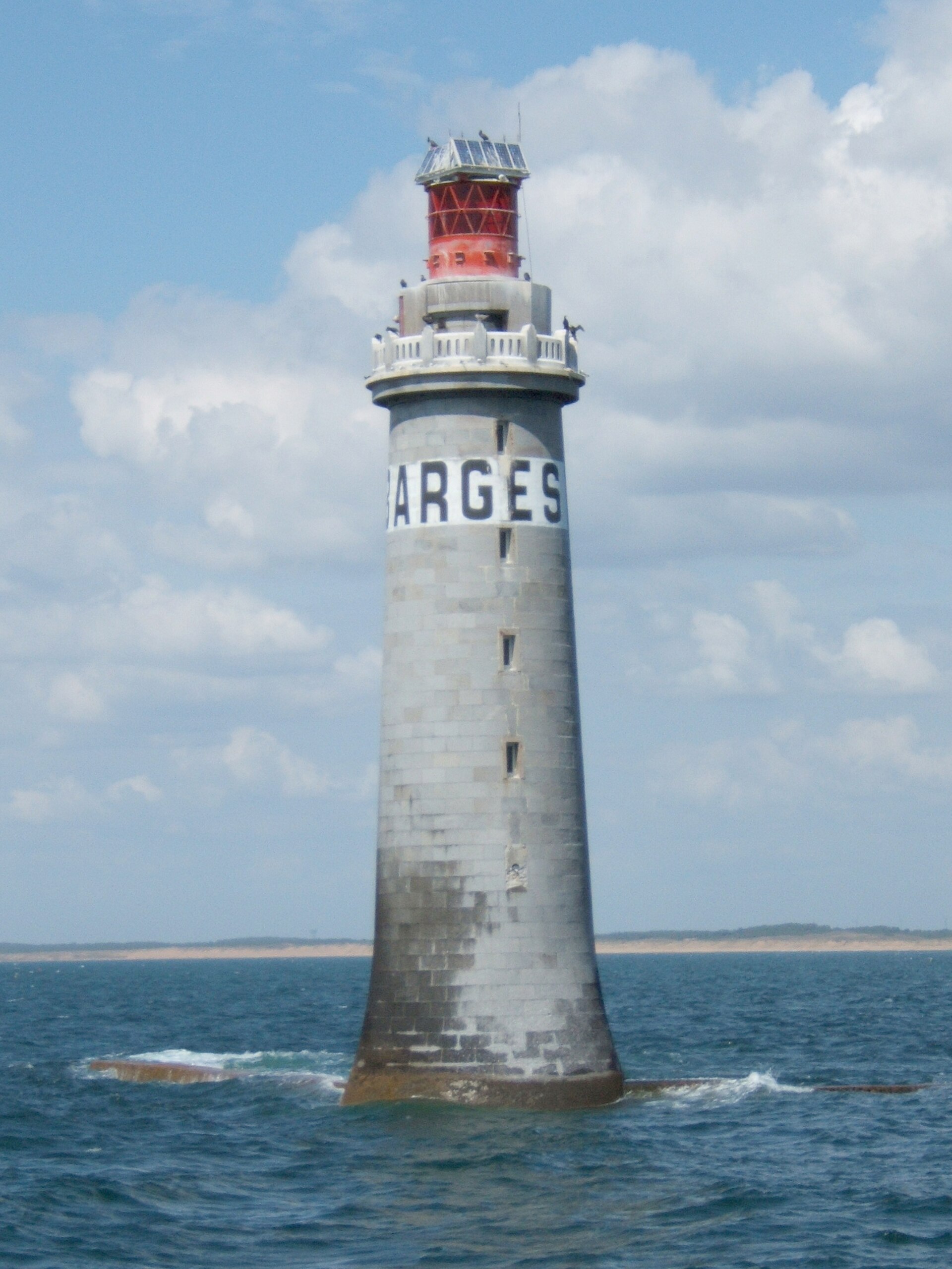
Phare des Barges
Phare des Barges is a lighthouse standing on the rocky Grandes Barges reef, roughly 2 km off La Chaume, part of the town of Les Sables-d'Olonne in the Vendée region on France's Atlantic coast. It rises alone out of the sea at a spot that has long posed a hazard to ships approaching the port of Les Sables-d'Olonne. Where exactly is the lighthouse located? The Barges are a cluster of dangerous rocks breaking the surface right at the approach to the port of Les Sables-d'Olonne. The lighthouse was built directly on this reef plateau to warn ships away from the submerged obstacles below. It can be seen from the town's beaches and quays, and the closest views come from the tourist boat trips that leave the harbour and head out past the mouth of the Auzance river. When was it built, and how long did construction take? Work on the lighthouse began in 1857 and finished in 1861 — a four-year build that was no small engineering feat, given that the site was only reachable when sea conditions allowed. The lighthouse was formally lit and put into service on 14 October 1861, becoming one of the key navigation markers along this stretch of the Vendée coast. What is the tower made of, and how tall is it? The structure was built from blue granite quarried at Avrillé, a town further inland in the Vendée. The tower stands 24.81 metres tall with a base 12 metres in diameter — a solid, squat shape designed to withstand the full force of wind and waves in such an exposed, open-sea position. What makes this lighthouse historically significant? Phare des Barges holds two notable firsts in the history of French maritime lighting. In 1963, at the initiative of broadcaster Jean Nohain and the magazine "Télé 7 Jours," it became the first lighthouse in France fitted with a television set, a gesture meant to highlight the modernisation of the lighthouse service. Then, in 1971, it became the first fully automated lighthouse in the country, marking the end of on-site keepers and the start of remote-controlled navigation lighting. Can visitors go inside? The lighthouse is not open to the public — its position on an exposed reef, surrounded by water and accessible only under specific sea conditions, effectively rules out regular interior visits. It can, however, be admired from the outside, ideally on a boat trip along the Les Sables-d'Olonne coastline, or from land at the beaches, the harbour promenade, or vantage points around La Chaume. Since 21 October 2011, the lighthouse has been listed as a historic monument (monument historique), recognising its value to the region's maritime heritage. Why is it worth noticing on a visit to the Vendée? For visitors to Les Sables-d'Olonne, best known as the starting point of the Vendée Globe round-the-world race, Phare des Barges is a tangible symbol of the town's maritime history. It also makes a striking photography subject — its solitary silhouette against the sea, especially at sunset or during stormy weather, is one of the most recognisable sights along this part of the Atlantic coast. Frequently asked questions Can Phare des Barges be seen from the beach? Yes, the lighthouse is visible from the beaches and quays of Les Sables-d'Olonne and from the La Chaume district, though it stands about 2 km offshore on open water. Who designed and built the lighthouse? Available sources do not name a specific architect — what is documented is that construction ran from 1857 to 1861 and that the structure was built from granite quarried at Avrillé. Is the lighthouse still operating, and is it automated? Yes, it remains an active navigation aid; since 1971 it has operated fully automatically, with no keeper required on site. Is it possible to go inside the lighthouse? No, the interior is not open to visitors because of its isolated offshore location — it can only be viewed from the outside, either from land or from the water.
-
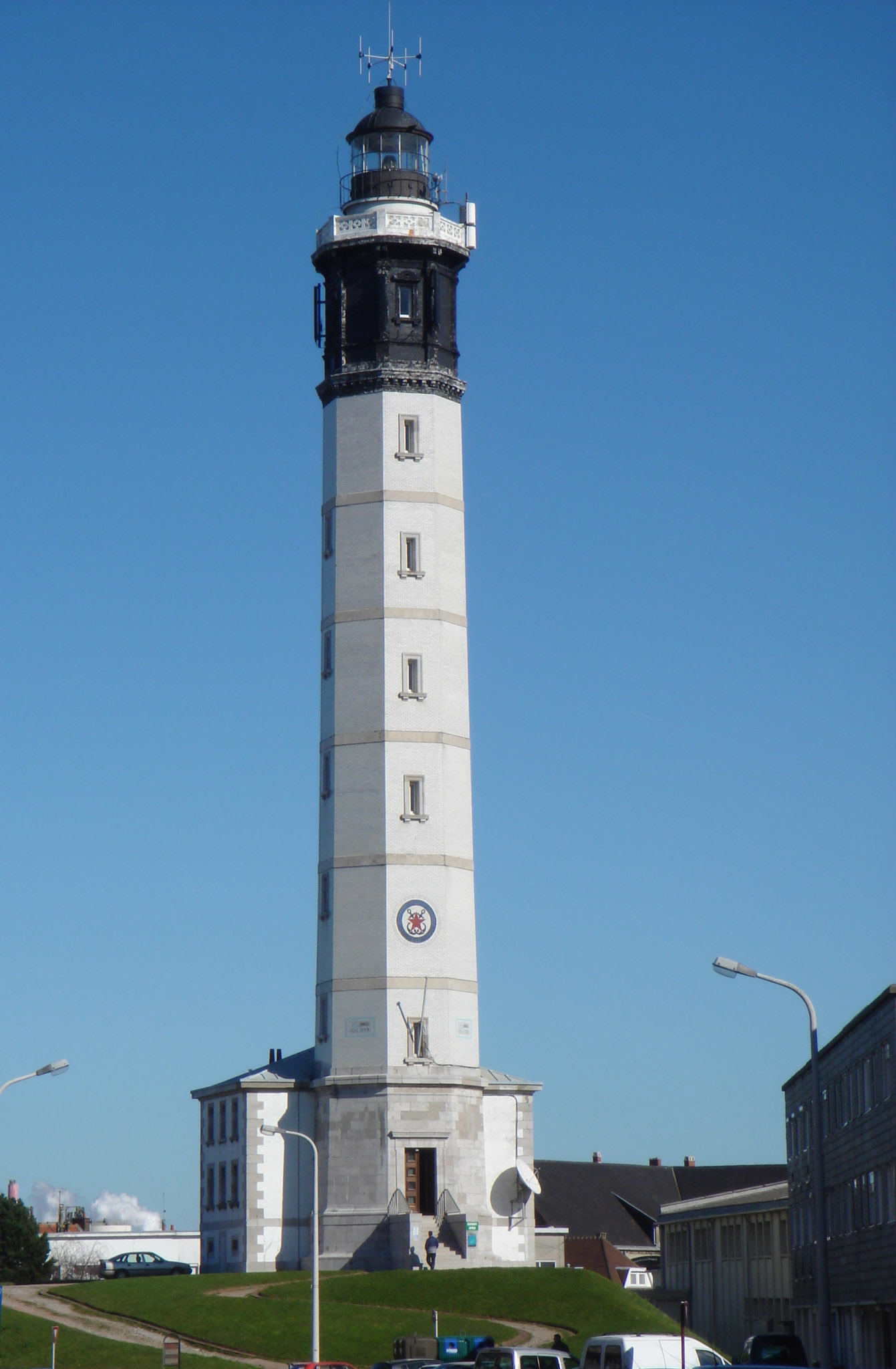
Calais Lighthouse
Calais
Calais Lighthouse stands in Calais, in the Pas-de-Calais department of northern France. Set among quiet residential streets close to the Port of Calais, it has long served as a navigational aid for ships and ferries crossing the Straits of Dover, one of the busiest shipping lanes in the world. Where exactly is the lighthouse located? The lighthouse sits within an ordinary residential neighbourhood a short walk from the harbour front. Its tall white tower stands out clearly against the surrounding rooftops, making it an easy landmark to spot while walking around town. The site sits at roughly 50.961 N, 1.854 E, placing it close to the heart of Calais and within easy reach of the town's other coastal attractions. What role does the lighthouse still play today? The lighthouse's core purpose hasn't changed since it was built: guiding vessels safely through the Straits of Dover. This narrow stretch of the English Channel carries an enormous volume of maritime traffic, from passenger ferries and cargo ships to smaller leisure craft crossing between France and the United Kingdom. The light helps crews judge their position relative to the coastline and the entrance to the port, which matters especially given the changeable visibility common to this part of the Channel. Why is it worth seeing when visiting Calais? Beyond its practical function, the lighthouse is one of the town's recognisable symbols. Calais has served as a gateway between continental Europe and the British Isles for centuries, and the lighthouse is a visual reminder of that role, standing watch over waters that hundreds of vessels cross every day. For visitors exploring Calais, it makes a natural stop on a walk connecting the old town with the harbour, offering a chance to see the town from a maritime angle. What should you know before visiting? Because the lighthouse sits in a residential area, its surroundings stay calm and free of the crowds found at more touristy spots in Calais. That makes it a pleasant place for an unhurried walk, particularly when combined with a visit to the port or the seafront. It's worth bringing a camera: the white tower set against the sky and the surrounding architecture makes for a striking shot, especially around dusk when the light comes on. Frequently asked questions Where exactly is Calais Lighthouse located? It stands in Calais, in the Pas-de-Calais department, within a residential area near the town's port, at approximately 50.961 N, 1.854 E. Is the lighthouse still an active navigational aid? Yes, it continues to help ships and ferries crossing the Straits of Dover judge their position relative to the shoreline and the entrance to the Port of Calais. Can visitors go inside the lighthouse? The available sources don't indicate regular public access to the interior — it's best to check current information locally or with the tourist information office before planning a visit. Is the lighthouse easy to reach on foot? Yes, it stands among ordinary town streets, so reaching it on foot from central Calais or from around the port is straightforward.
-
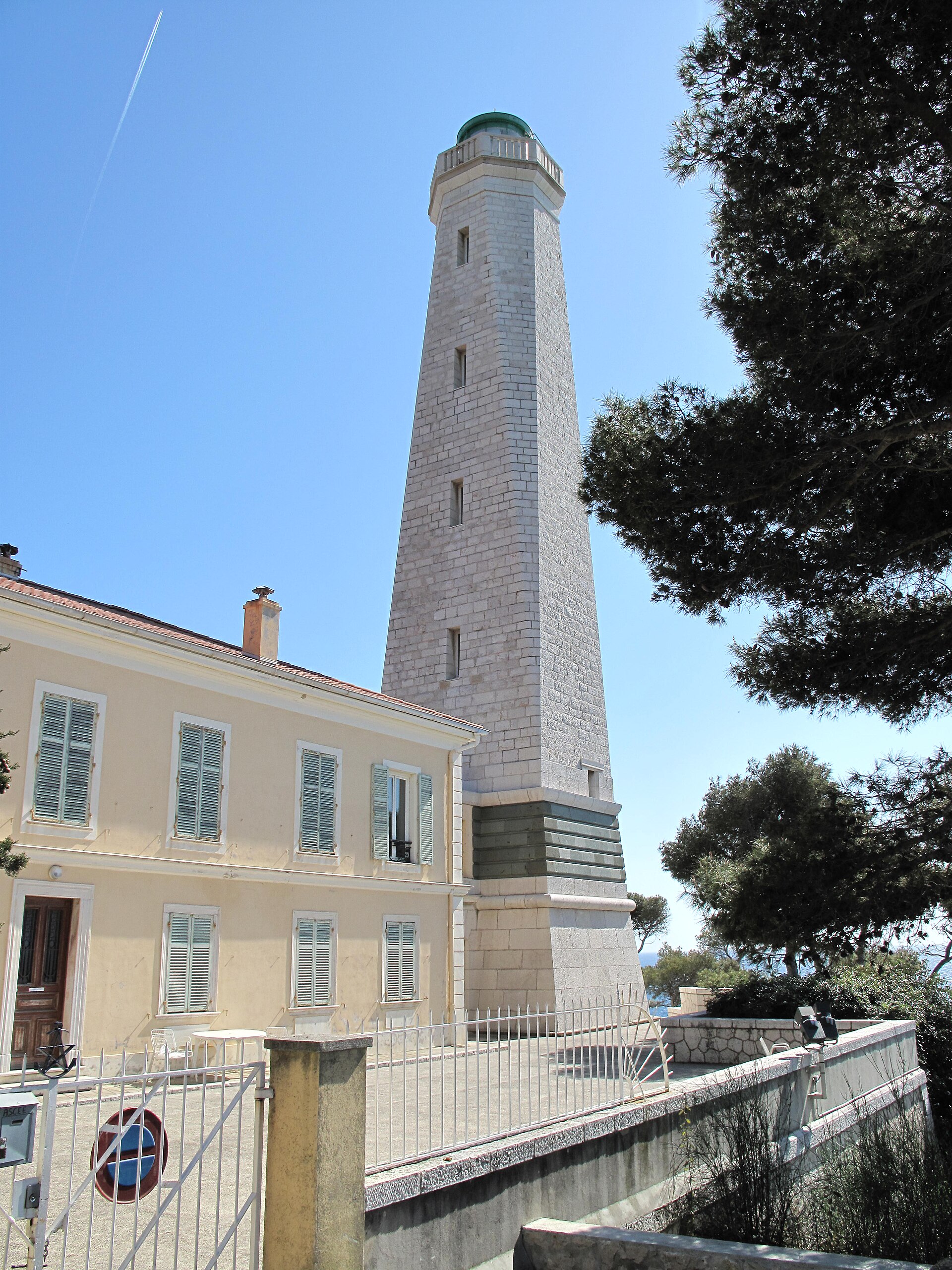
Cap Ferrat Phare
Saint-Jean-Cap-Ferrat
The Cap-Ferrat lighthouse stands at the tip of the rocky Saint-Jean-Cap-Ferrat peninsula, right at the heart of the French Riviera in the Alpes-Maritimes department. It is one of the most recognisable landmarks in the area — a white tower rising above the Mediterranean that has guided sailors along this stretch of coast for centuries. Where is the lighthouse and how do you get there? The lighthouse sits on the chemin du Phare, at the very tip of the Cap-Ferrat peninsula, a short distance from the town of Saint-Jean-Cap-Ferrat. Its coordinates are 43.6753 N, 7.32694 E. The easiest way to reach it is on foot, following the coastal path that hugs the shoreline — a walk through pine trees and rocky coves that ranks among the most popular outdoor activities on this part of the Riviera. From the viewpoint next to the lighthouse, the panorama stretches from the Estérel massif all the way to the Italian coast, making it one of the best lookout spots on the entire Riviera. What is the history of the Cap-Ferrat lighthouse? The current lighthouse was built in 1732, replacing a much older 16th-century fire tower that had previously warned ships away from the peninsula's dangerous rocks. The structure served for more than two centuries until the Second World War, when it was destroyed in 1944 amid fighting along the coast. After the war it was rebuilt close to its original form, restoring its role in guiding ships along this section of the Mediterranean. In 2012 the lighthouse was granted historic monument status, recognising both its architectural value and its place in the region's maritime heritage. Can visitors go inside the lighthouse? The interior is not open for casual visits — the building remains closed to the public and continues to operate purely as a working navigation aid. That said, reaching the lighthouse itself is entirely possible and is a popular goal for walks around the peninsula. The grounds around the tower, including the paths and viewpoints, are freely accessible, and the sweeping view over the sea and rocky coastline is the main reason visitors come here. What else is worth seeing near the lighthouse? Cap-Ferrat is one of the most exclusive corners of the French Riviera, known for its villas surrounded by gardens and its coastal walking paths. Near the lighthouse, it's worth following a stretch of the sentier du littoral, the coastal trail that circles the entire peninsula, passing rocky coves, small beaches and green stretches along the way. The town of Saint-Jean-Cap-Ferrat, with its marina and narrow streets, lies a short walk from the lighthouse and makes a natural base for exploring the rest of the peninsula. Frequently asked questions Is the Cap-Ferrat lighthouse open to visitors? No, the interior is not open to the public. You can, however, walk right up to its base and enjoy the surrounding viewpoints and paths. When was the Cap-Ferrat lighthouse built? The current tower dates from 1732 and replaced an older 16th-century structure that warned sailors of the peninsula's rocks. Was the lighthouse destroyed during the war? Yes, it was destroyed in 1944 during the Second World War and later rebuilt close to its original design. How do you walk to the lighthouse from Saint-Jean-Cap-Ferrat? The best route is on foot along the sentier du littoral, the coastal path that runs around the whole peninsula and passes several scenic viewpoints.
-
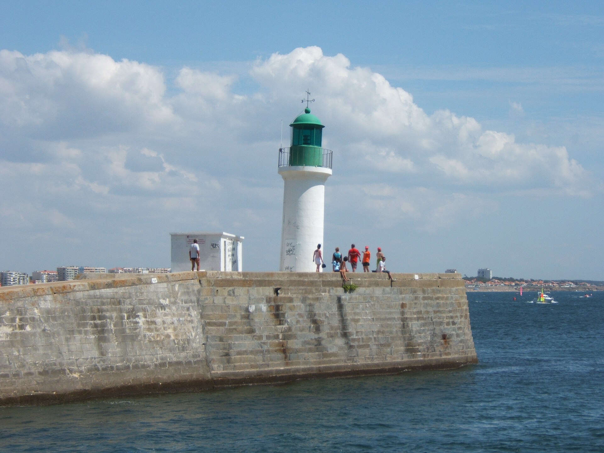
Les Sables-d'Olonne East Jetty Light
Les Sables-d'Olonne
Les Sables-d'Olonne East Jetty Light is the red lighthouse standing at the tip of the Grande Jetée (also known as Jetée Saint-Nicolas) in Les Sables-d'Olonne, in France's Vendée department. It marks the eastern side of the harbour entrance and is one of the most recognisable landmarks along this seaside town's waterfront. Where exactly does the lighthouse stand? The light sits at the far end of the Grande Jetée, the longer of the two jetties that shelter the entrance to the harbour at Les Sables-d'Olonne. Across the channel, on the shorter Petite Jetée, stands its green counterpart — together the two lights form the classic French harbour marking system, with red on one side and green on the other. The lighthouse's coordinates are 46.4906527, -1.7917598, and the jetty itself stretches out to sea toward the southeast, offering sweeping views of the Grande Plage, the fishing and sailing harbour, and the open Atlantic beyond. How far back does the jetty's history go? The Saint-Nicolas jetty, on which the lighthouse now stands, dates back to 1764–1765, when a first dry-stone structure with a convex shape was built to shield the harbour mouth from incoming waves. Between 1876 and 1883, the jetty was extended by roughly 100 metres toward the southeast to better protect the harbour entrance from Atlantic storms. The lighthouse visitors see today was completed in 1910, added as the finishing touch to the enlarged jetty. What does the structure look like, and how does it work? The tower stands 12.50 metres tall and is built of dressed granite ashlar — a material long favoured for coastal structures in the Vendée for its resistance to salt and damp. When it first entered service, the light burned mineral oil and had no permanent keeper: it operated unattended thanks to an electric rotating mechanism that produced its distinctive flashing signal, visible far out at sea. The lighthouse remains an active aid to navigation today, guiding fishing boats, yachts, and pleasure craft safely into port at any hour and in any weather. What else is worth seeing nearby? Walking the length of the Grande Jetée out to the lighthouse is one of the most popular short outings in Les Sables-d'Olonne. From the jetty, the view stretches across the entire Grande Plage — the town's main beach — as well as the constant traffic of boats entering and leaving the harbour. It's a favourite spot for locals and anglers alike, especially at high tide, when waves break against the stone breakwater. Over the years the lighthouse has become something of an unofficial emblem of the town, a familiar sight on postcards and regional tourism material. Frequently asked questions Can visitors go inside the lighthouse? No — it remains an active navigational aid and is not open to the public inside, but it can be freely viewed and photographed from the jetty itself. How do you reach the lighthouse from central Les Sables-d'Olonne? The Grande Jetée sits right next to the harbour and the Grande Plage, within easy walking distance of the town centre — the stroll out to the light typically takes only about fifteen minutes. Why is the lighthouse painted red? The colour follows the international system of maritime markers: a red light on the eastern side of a harbour entrance, paired with a green light opposite on the Petite Jetée, helps sailors quickly identify the safe channel into port. Is sunset a good time to visit the jetty? Yes — early evening is a popular time for a walk along the Grande Jetée, when the setting sun reflects off the ocean and the lighthouse begins its nightly flash, making for one of the town's most photogenic views.
-
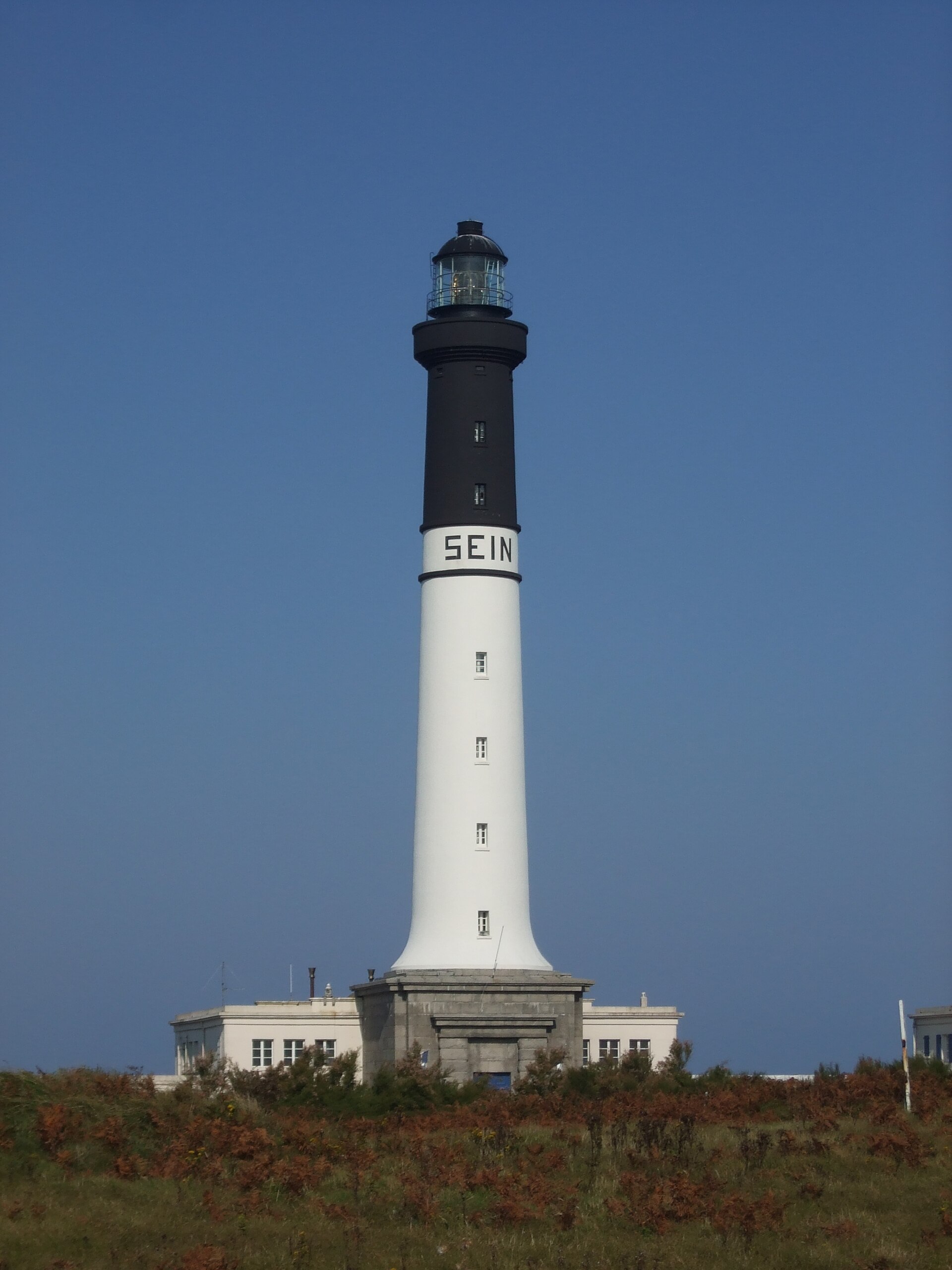
Grand phare de l'île de Sein
Quimper
The Grand phare de l'île de Sein is the main lighthouse of Île de Sein, a small, flat island off the coast of Finistère in Brittany. Sitting a dozen or so kilometers from the mainland, the island guards one of the Atlantic's most notoriously difficult stretches of water, the Raz de Sein, and for nearly two centuries the lighthouse has warned ships away from the rocks and currents running west toward the wider Sein archipelago. How do you get to Île de Sein? There is no bridge — the only way in is by ferry, most commonly from Audierne, a small port near the famous Pointe du Raz. The crossing takes roughly an hour and can get rough in strong wind, which says a lot about why a lighthouse here has always been a necessity rather than a nicety. Once on the island, there are no cars: everything is seen on foot, and the walk from the harbor to the lighthouse usually takes 20 to 30 minutes along the coastline. What will you see at the Grand Phare? The first tower and its history The original Grand Phare was first lit on May 15, 1839. Built from pink granite as a cylindrical tower with a base rising 43 meters, the work was carried out by Michel Piquemard, a contractor from Morlaix, under the supervision of engineer de Kermel. In its earliest years the light burned rapeseed oil, before lighting technology moved on. In 1876 the top of the tower was painted black over a height of 12 meters so sailors could identify it more easily by day. An oil-gas plant was added in 1896 to power the light, and a power station followed in 1932. The lighthouse was fully electrified on December 15, 1935. Destruction in 1944 and rebuilding On August 4, 1944, as German troops withdrew from the island, they stored ammunition in a cave inside the lighthouse. The resulting explosion destroyed the nineteenth-century tower almost entirely. A new lighthouse was built between 1950 and 1951 at the northwestern tip of the island, on a different spot from the original structure. Today's Grand Phare stands 50.90 meters tall, with an internal cylindrical shaft 3.50 meters in diameter — making it one of the taller lighthouses on the Breton coast. The landscape around the lighthouse Île de Sein is so flat that the lighthouse is visible from almost anywhere on the island and serves as its natural landmark. The surroundings are lined with the rocky shoals typical of this part of Finistère, and on clear days the upper levels of the tower, when open to visitors, offer views out over the Sein archipelago and the open Atlantic. When should you visit? Spring and summer are the best times to come, when the weather is more stable and the ferry crossing less unpredictable. In autumn and winter the Raz de Sein can turn genuinely rough, and ferry crossings are more often cancelled due to storms — worth factoring in if you're planning a day trip. Frequently asked questions Can you go inside the lighthouse? Access to the interior depends on the current rules set by France's lighthouse authority and can vary by season — it's best to check locally, at the harbor or the island's tourist office, before you plan your visit around it. Is the lighthouse standing today the original nineteenth-century structure? No. The original 1839 tower was destroyed by an ammunition explosion in 1944. The current lighthouse dates from 1950–1951. How long is the walk from the harbor to the lighthouse? Around 20 to 30 minutes on foot along the coast, depending on pace and wind conditions. Are there cars on the island? No — Île de Sein is explored entirely on foot, one of the reasons it has kept its raw, unspoiled character.
-
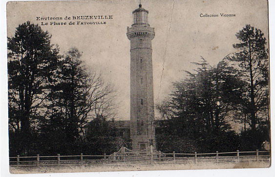
Phare de Fatouville
Fatouville-Grestain
Phare de Fatouville is a historic lighthouse in the commune of Fatouville-Grestain in Normandy, standing today at some distance from the Seine, even though it was originally built to watch over the river's estuary. It is an unusual case of a lighthouse that lost its navigational role and turned into a private family home, while still keeping its 19th-century character and heritage status. Why was a lighthouse built at Fatouville? Construction began in 1839 and was completed in 1850, with most of the building work carried out between 1849 and 1850. The design came from Léonce Reynaud, one of the most respected lighthouse architects of the 19th century, known for his work lighting the French coast. The Fatouville lighthouse was part of a wider network of navigational lights guiding ships along the lower Seine, helping vessels find a safe course upriver toward Rouen. The tower stands 33 metres tall, and its light could once be seen from more than 40 kilometres away — an impressive range even set against larger coastal lighthouses of the period. Fatouville was not built directly on the open sea but above the river, so its job was to guide both coastal and inland shipping through a tricky stretch near the Seine's mouth. How did a lighthouse become someone's home? The lighthouse remained active until 1907. As embankment works reshaped the course of the Seine, the river's channel shifted and the lighthouse's original position lost its navigational relevance. In 1923 the building was sold, and its first private owner, Gaston David, converted the tower and its outbuildings into a family residence. The lighthouse has stayed in the same family ever since. Since 2000, part of the building has operated as guest rooms, giving visitors the chance not just to admire the tower from outside but to actually stay overnight in a place with such an unusual past. In 2011, Phare de Fatouville was officially listed as a historic monument, recognising its value as a surviving example of 19th-century lighthouse engineering. What is there to see on site? The main draw is the lighthouse's architecture itself: a solid stone tower with the proportions typical of Reynaud's design work, surrounded by outbuildings that have been adapted for residential and hospitality use. It is a rare chance to encounter a lighthouse not as a museum piece, but as a lived-in building where history and everyday life sit side by side. Fatouville-Grestain lies near the Seine estuary, not far from other lighthouses along the same stretch of coast, making it easy to combine a visit here with a broader tour of Normandy's lighthouses. How do you get to Phare de Fatouville? Fatouville-Grestain is located in the Eure department of Normandy, close to Honfleur and the Pont de Normandie. Travelling by car is the most practical option, since the village sits on local roads connecting the coast with Pont-Audemer and Honfleur. Because the lighthouse is now a private property that also runs guest rooms, going inside is generally reserved for overnight guests; the exterior, however, can be viewed freely. When is the best time to visit? Spring and summer are the best seasons to visit, as longer days make it easier to enjoy the surroundings of the Seine estuary and the grounds around the lighthouse are more accessible. Anyone planning to stay in the guest rooms should book ahead, especially during the summer holiday season. Frequently asked questions Is Phare de Fatouville still an active lighthouse? No. It stopped functioning as a navigational aid in 1907 and no longer guides ships. Who owns the lighthouse today? Since 1923 it has belonged to the family of Gaston David, who turned it into a private residence and, since 2000, has also run guest rooms there. Can visitors go inside the lighthouse? Since it is a private home with a small guesthouse operation, the interior is mainly accessible to overnight guests. Why did the lighthouse stop being needed? Embankment works changed the course of the Seine, shifting the river channel and leaving the lighthouse's original position without navigational purpose.
-
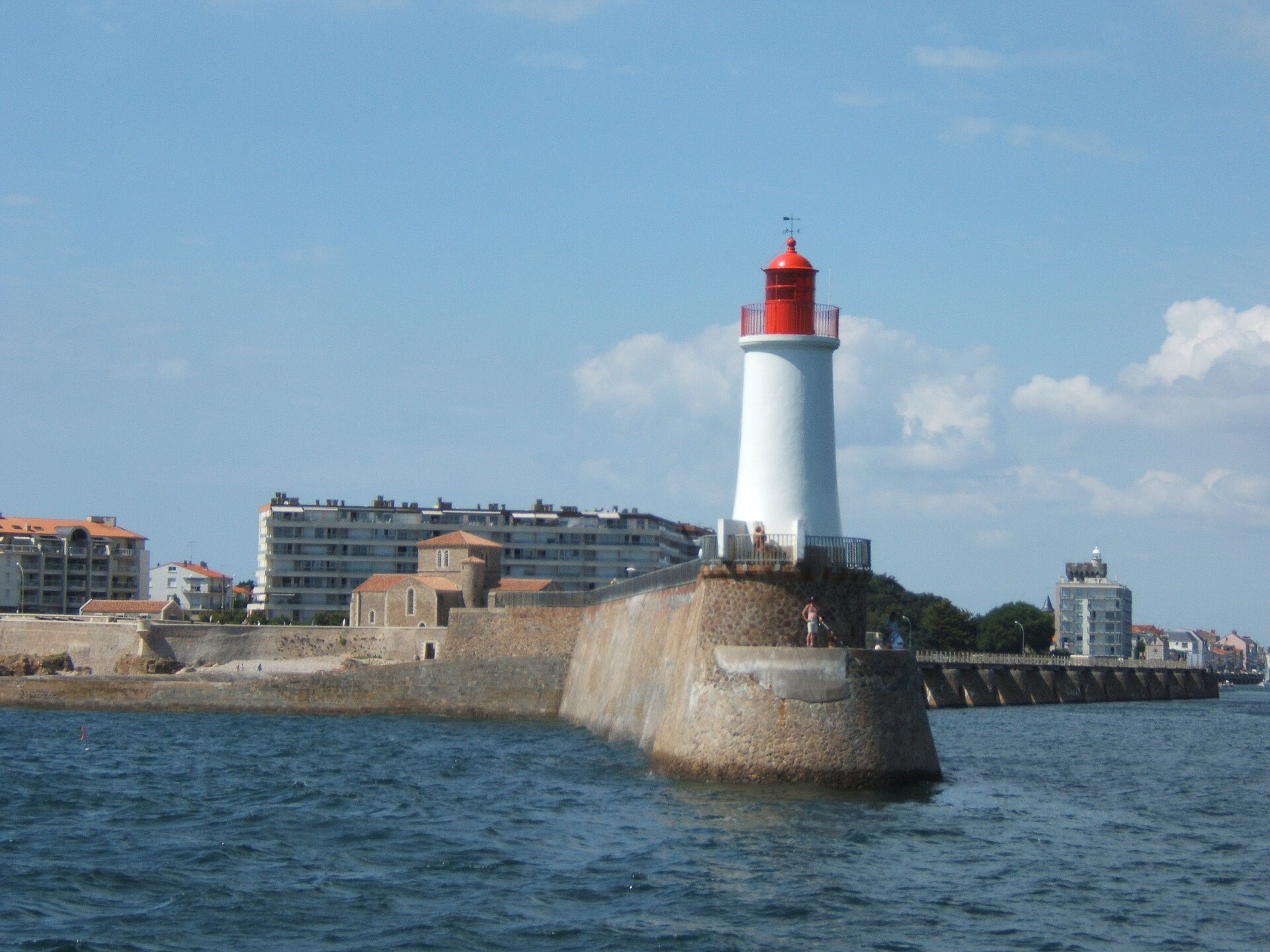
Les Sables-d'Olonne West Jetty light
Les Sables-d'Olonne
The West Jetty light (Phare de la Jetée Saint-Nicolas) stands at the tip of the Grande Jetée in Les Sables-d'Olonne, marking the entrance to the harbour channel on the La Chaume side, in the Vendée department of France. What is this landmark? It's a compact but distinctive lighthouse built of cut granite, rising to roughly 12.5 metres. It caps the Grande Jetée, also known as the Jetée Saint-Nicolas, whose construction began back in 1764 but wasn't finished until 1910. The lighthouse itself was completed in December of that year. In its early days it burned mineral oil and had no permanent keeper — the rotating mechanism that turned its light was driven electrically, an unusually modern touch for the period. The light flashes red, letting sailors tell it apart from the green light on the smaller jetty across the channel. The structure is listed as a protected historic monument in France. How do you get there? The jetty sits on the La Chaume side of the port, opposite the town centre and main beach across the harbour channel. The easiest way to reach it is on foot along the quay, walking through the fishing district of La Chaume, past moored trawlers and fish stalls, all the way out to the tip of the jetty. It's a favourite route for locals and visitors looking for an ocean view with fewer crowds than the main seafront promenade. What will you see there? The lighthouse itself is modest in size, but its position at the far end of a long jetty makes the visit worthwhile — open Atlantic swell on one side, the harbour channel with boats coming and going on the other. Les Sables-d'Olonne is one of France's notable sailing ports, home port of the Vendée Globe round-the-world race, so it's common to see fishing boats, yachts and sailboats moving through the channel. Timing your visit to coincide with vessels entering or leaving the port makes for a good vantage point. The granite lighthouse, small as it is, stands out sharply against the open sea and sky, making the spot a favourite for photos, especially around sunset. When should you visit? The jetty is open year-round, but walking conditions are best from spring through early autumn, when weather along this stretch of Atlantic coast tends to be calmer. In strong wind or high swell, reaching the very end of the jetty can be uncomfortable or unsafe, so it's worth checking the forecast beforehand. Early morning, when the port comes to life and fishing boats return with their catch, is a good time to see the lighthouse as part of the working rhythm of the harbour. Frequently asked questions Can you go inside the lighthouse? No, it's an active maritime signal station, not open to visitors inside. It can only be viewed from outside while walking the jetty. How is it different from the Tour d'Arundel in the same town? They're two entirely different structures. The Tour d'Arundel is a medieval tower in another part of the port, while the West Jetty light is a much younger granite structure from the early 20th century, standing at the tip of the Grande Jetée at the channel entrance. Is there an entrance fee to walk the jetty? No, the jetty is part of the public port infrastructure, and walking out to the lighthouse is free. Are there other things to see nearby? Yes — the La Chaume fishing district, with its quay, fish market and seafood restaurants, sits right next to the jetty on the same side of the channel.
-
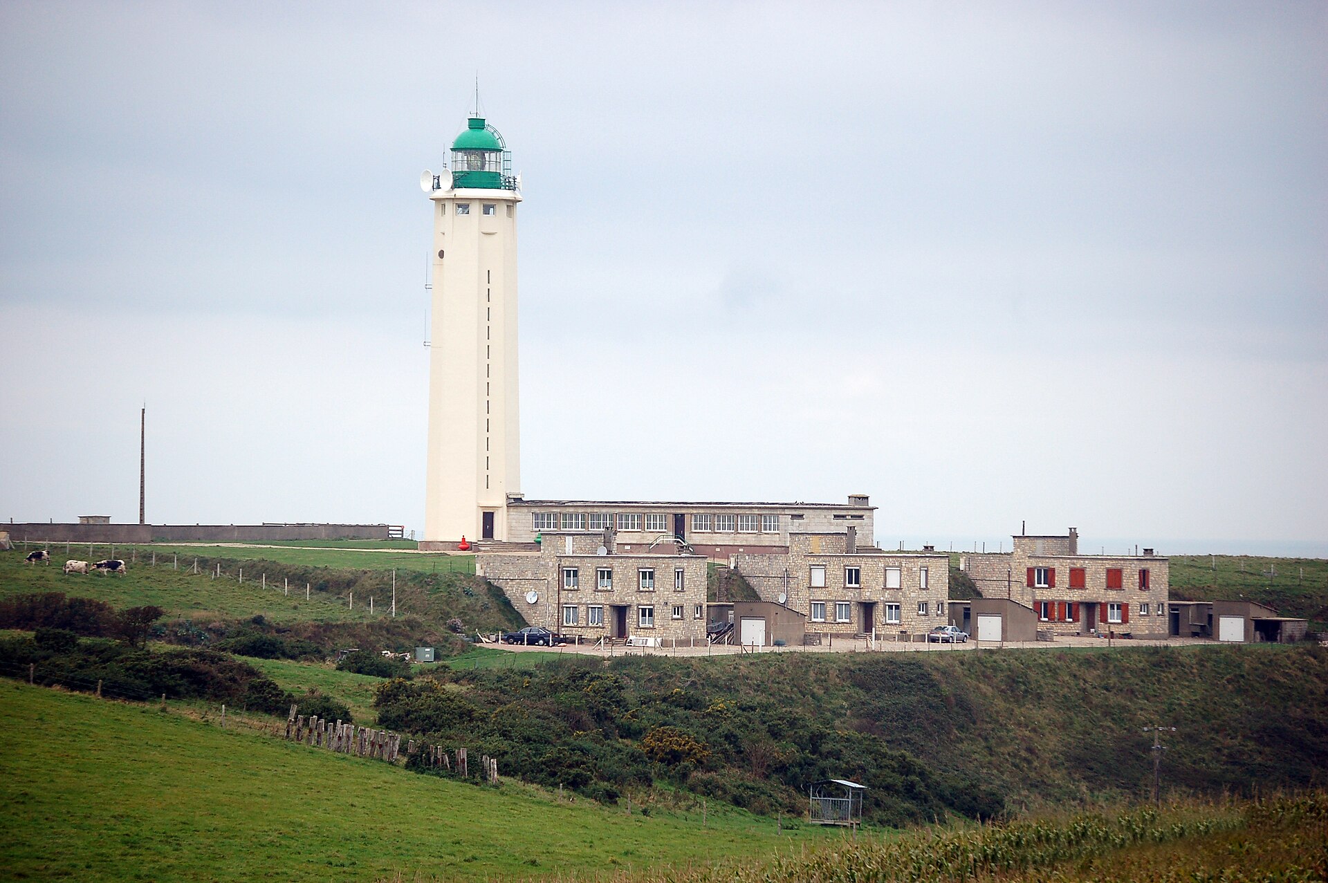
Cap d'Antifer Lighthouse
La Poterie-Cap-d'Antifer
Cap d'Antifer Lighthouse stands on the cliffs of La Poterie-Cap-d'Antifer, along the Côte d'Albâtre on the English Channel, in the Seine-Maritime department of Normandy. It's a working aid to navigation, guiding ships toward the Port of Le Havre — one of France's largest ports, a short distance south along the coast. Where is it and why here? Cap d'Antifer sits at a strategic point for vessels approaching the mouth of the Seine and the port of Le Havre, a stretch of water that has carried heavy shipping traffic for decades, from container ships to tankers heading for oil terminals. A light placed right on the cliff edge is visible far out over the open Channel, well before ships reach the busier approach to the port itself. The surrounding landscape is classic Côte d'Albâtre: pale chalk cliffs dropping sharply to the sea, running in an unbroken line from Étretat to Le Havre. La Poterie-Cap-d'Antifer itself is a small, quiet commune that sees far fewer visitors than nearby Étretat, which makes it a good choice for anyone looking for the same coastline without the crowds. How do you get there? Driving is the easiest way in — from Le Havre it's a trip of a quarter of an hour or so, and even shorter from Étretat. Local roads cross the farmland typical of the Pays de Caux plateau before the terrain starts dropping toward the cliffs. It's worth parking nearby and continuing on foot: the lighthouse compound itself is closed to vehicle traffic, but the coastal paths around it are open to walk. Walkers and cyclists can also reach the cape via the coastal trail that runs the length of the Côte d'Albâtre, a well-used route linking the seaside towns along this stretch, with the cliffs and the Channel on one side the whole way. What will you see? The lighthouse itself is best appreciated from outside and at a distance — it's a working navigation structure, not a museum you walk into. The real draw is the setting around it: sweeping views over the English Channel, the cliff line stretching in both directions, and shipping traffic heading toward Le Havre, with large vessels sometimes clearly visible as they make for the Seine estuary. It's a spot that resonates especially with anyone interested in maritime history and navigation — watching a working light doing its job for traffic bound for one of Europe's key ports carries some weight, even without going inside. When should you visit? Clear-weather days give the best views — spring and summer tend to bring calmer seas and longer daylight, making it easier to take in the cliffs and the passing ships. In autumn and winter the cape is heavily exposed to wind off the Channel, which has its own stark appeal but calls for warmer clothing and care on the cliff-top paths. It's worth avoiding days with heavy fog, which this coast gets fairly often — the lighthouse itself can be hard to make out then, though that's exactly the condition where its practical purpose becomes obvious. Frequently asked questions Can you go inside Cap d'Antifer Lighthouse? No — it's an active navigation aid serving traffic bound for Le Havre, not a tourist site open to visitors. You view it from outside, from the paths along the cliff top. How far is it from Le Havre? Le Havre lies to the south of the cape, roughly a fifteen- to thirty-minute drive away — which is exactly why the lighthouse was built here: to guide ships into that port. Is it worth combining with a visit to Étretat? Yes. Étretat sits nearby on the same Côte d'Albâtre and draws far more visitors — Cap d'Antifer makes a quieter counterpoint for anyone who wants the same cliff scenery without the crowds. Is the light meant to be seen from land or from the sea? Primarily the sea — the lighthouse exists to be visible to ships crossing the Channel and approaching Le Havre. The view from the cliff top on land is really a bonus for visitors, not its main purpose.
-
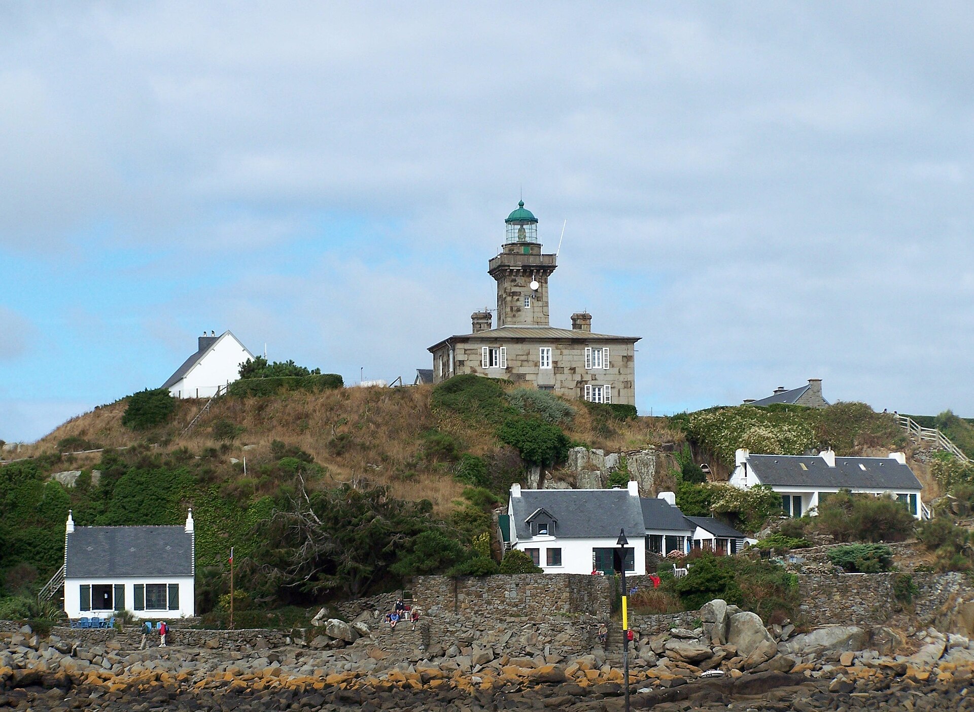
Phare de Chausey
Granville
Phare de Chausey stands on Grande-Île, the main island of the Chausey archipelago off Granville, in the Manche department of Normandy. Rising among granite reefs and shoals that have long made this stretch of the Gulf of Saint-Malo treacherous, the lighthouse still guides boats safely between the hundreds of rocks and islets that appear when the tide falls. Why was a lighthouse built here? The 1825 lighting plan for the Normandy coast called for just one beacon, at Granville itself. Experience soon showed this wasn't enough: the Chausey archipelago, riddled with islands and hidden rocks, remained dangerous for ships sailing at night or in fog. In 1842 the authorities decided a second lighthouse was needed, this time on Chausey. The design came from engineer Léonce Reynaud, who had already built the lighthouse at Carteret and drew on that experience for the new project. Contractors from Caen carried out the construction, which began in 1846 and finished the following year. The lighthouse was formally put into service on 27 May 1848. What makes the tower itself worth a closer look? Builders used blue granite quarried right on the archipelago's own islands, giving the tower the cool, distinctive tone it still has today. The tower itself rises 19 metres, but because it sits on raised ground, its light shines from 37 metres above sea level, extending its reach well beyond what the tower's height alone would suggest. Inside, the layout has a few unusual touches: the staircase was set off to one side to leave room for a proper entrance hall, and the keepers' individual living quarters were each fitted with an alcove, a small cabinet, and windows facing different directions so that daylight would reach the rooms for as much of the day as possible. Such attention to the comfort of the people who lived and worked there was uncommon for lighthouses of this period. What has the lighthouse been through? The Second World War left its mark: on 9 March 1945 a German attack partially destroyed the structure. Repairs and modernisation took a few years — electricity reached the lighthouse in 1949, and its light was relit in 1950. A further turning point came in 2008, when the lighthouse was fully automated and no longer needed a resident keeper; it's now overseen by the lighthouse and beacon authority based in Granville. By decree of 11 May 2009, the lighthouse, together with its garden walls and former powder magazine, was listed as a historic monument — the only exclusion being the old France Télécom building on the site. How do you get to Chausey to see it? There's no road to the Chausey archipelago — the only way in is by sea, on a ferry or excursion boat departing from the harbour at Granville. The crossing takes roughly 40 to 50 minutes, with several sailings a day depending on the season. The lighthouse stands on Grande-Île, the archipelago's only permanently inhabited island, so once you land you can simply walk to it — the stroll past granite fishermen's cottages and dunes is itself one of the highlights of a visit. It's worth timing the trip around the tides: at low water, hundreds of extra rocks and islets emerge, and the whole look of the archipelago shifts depending on how far the sea has retreated. When is the best time to visit? Spring through early autumn is the most comfortable window, with more frequent boat crossings and weather suited to a longer walk around the island. Checking a tide table before booking is worthwhile — the biggest low tides of the year expose far more of the archipelago's rocky landscape than an average tide ever will. Frequently asked questions Can you go inside the lighthouse? No — it's fully automated and not open for interior visits; visitors see it from the outside while walking around Grande-Île. How long is the boat trip from Granville? The crossing usually takes between 40 and 50 minutes, depending on conditions and route. Can you stay overnight on the island? Grande-Île has only limited accommodation, so most visitors plan a day trip built around the boat schedule and the tides. Why is the lighthouse built from granite? The builders used stone quarried directly on the archipelago's islands — a practical, economical choice, and granite holds up well against harsh sea conditions.
-
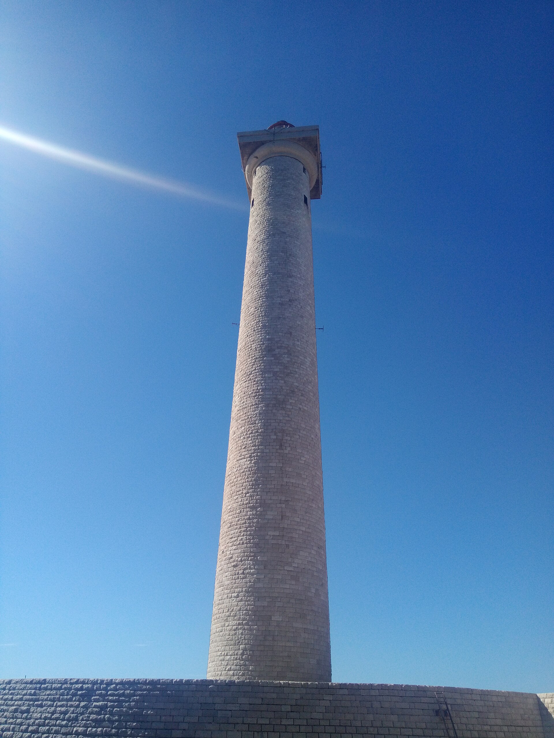
Planier Light
Marsylia
Planier Light stands alone on the small Île de Planier, roughly 13 kilometres off the coast of Marseille. It isn't a mass-tourism destination in the usual sense, but it is one of the most recognizable landmarks seen from boats leaving Marseille's harbor, and it draws both sightseeing cruises and diving trips exploring the waters around the island. What makes this lighthouse notable? The tower rises 66 metres (216 feet), making it one of the tallest traditional lighthouses in the world — it ranks twelfth globally by height. It sits on its own small island in the Bouches-du-Rhône department, well away from the mainland, which gives it a stark, isolated presence against the open sea. The light remains active, guiding ships around shoals and rocky ground as they approach the Bay of Marseille. Île de Planier has long been linked to maritime traffic and shipwrecks — the surrounding waters hide several wrecks that attract divers from across Provence. The island itself is small and largely uninhabited, with the lighthouse and its technical outbuildings forming essentially the whole of its infrastructure. How do you get to Planier Light? There's no regular ferry service for individual visitors. The main ways to reach the area are by chartering a boat from Marseille or joining a trip run by a local sailing or diving club. Most visitors never actually land on the island — instead, they see the lighthouse from the deck of a boat cruising along the coast toward the Calanques or the Frioul Islands. From central Marseille, the crossing typically takes 40 minutes to an hour, depending on the vessel and sea conditions. What will you actually see? The main draw is the tower itself: a tall, slender structure rising almost straight out of the sea, standing out sharply against the flat horizon of open water off Marseille. It's a favorite subject for sailors and anyone interested in maritime architecture. The rocky seabed and nearby wrecks also make the area a popular spot for recreational diving, organized through dive centers based in Marseille. A telephoto lens is worth packing — the lighthouse photographs particularly well against a sunset or morning sea mist. When is the best time to visit? The most favorable window for a trip out to Planier runs from May to September, when the sea is calmer and visibility is at its best. Summer conditions suit both scenic boat trips and wreck diving near the island. Outside the summer months, stronger winds and swell can make the crossing difficult, so it's worth checking marine forecasts and charter availability before planning a trip. The lighthouse also makes a good add-on for anyone spending several days in Marseille — it pairs naturally with a day out toward the Frioul archipelago or along the Calanques cliffs, allowing for one longer day spent entirely on the water. Frequently asked questions Can you land on Île de Planier? The island isn't open to general tourism. Access is mostly limited to lighthouse staff and participants of organized boat or diving excursions, usually without the chance to freely explore on foot. How tall is Planier Light? The tower stands 66 metres tall, placing it among the twelve tallest traditional lighthouses in the world. Is the lighthouse still operational? Yes, Planier Light is an active aid to navigation, guiding ships toward Marseille. What's the easiest way to see it without chartering your own boat? The simplest option is a scenic cruise or boat tour from Marseille heading toward the Frioul Islands or the Calanques — the lighthouse is clearly visible from the deck without needing to land on the island.
-
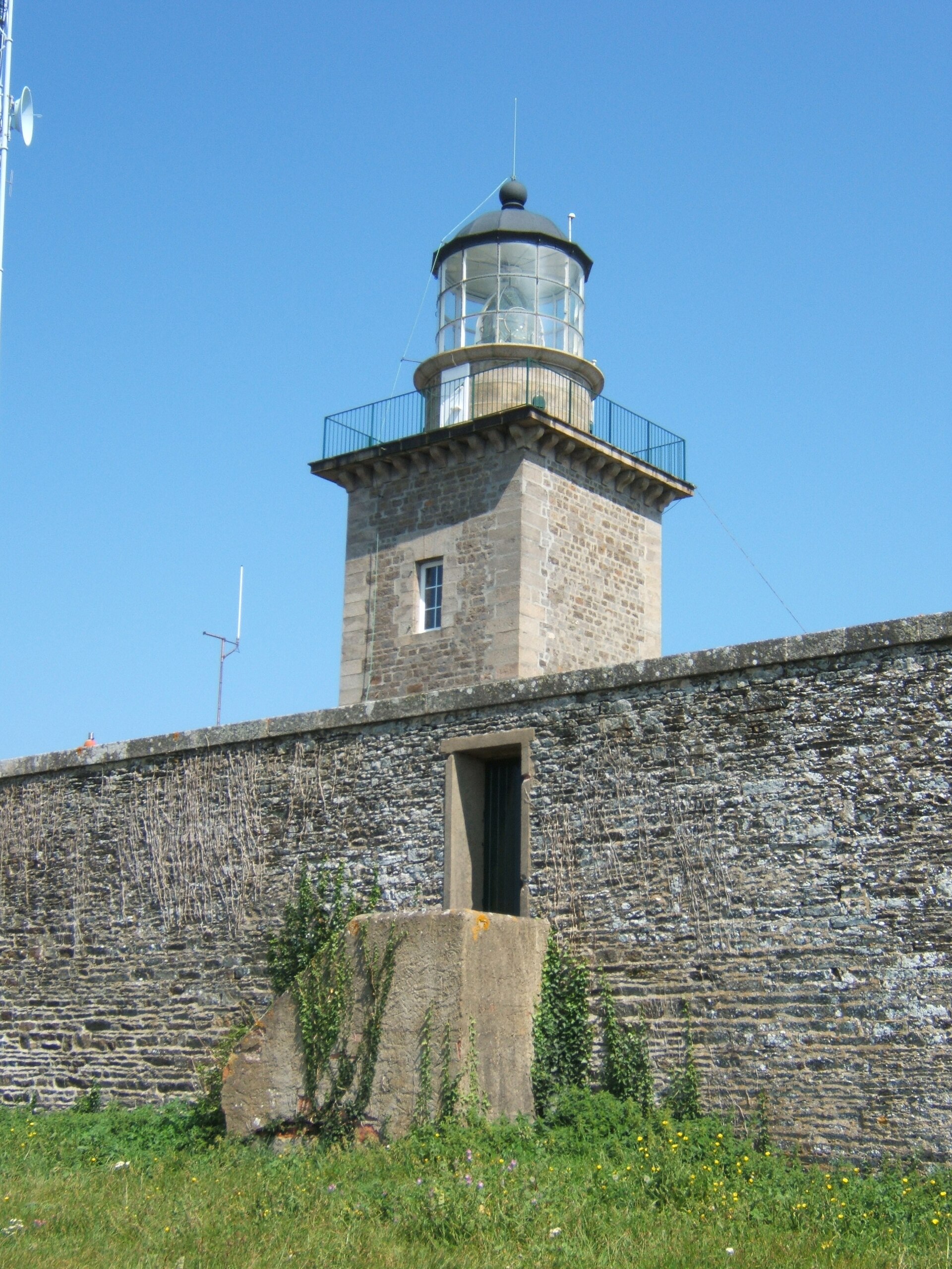
Phare de Carteret
Carteret
Phare de Carteret is a lighthouse perched on the cliffs of Cap de Carteret, in the commune of Barneville-Carteret in the Manche department, on Normandy's western coast. Standing guard above the English Channel, it has guided ships along this rocky, exposed stretch of the Cotentin peninsula for nearly two centuries. How do you get there? The lighthouse sits at the tip of the headland, a short distance from the center of Barneville-Carteret and its harbour, from which ferries depart for Jersey. By car, a local road climbs up to the headland, where a small car park is available. From there, it's a short walk across the grassy clifftop to reach the lighthouse itself. The site also lies directly on the GR223 coastal footpath, which circles the entire Cotentin peninsula, so many visitors arrive on foot as part of a longer clifftop walk. What will you see? The lighthouse takes the form of a square tower built into the front wall of a rectangular keeper's building, constructed from rough-cut stone with dressed stone quoins at the corners. The tower itself measures 15 metres in height, but because it stands atop a tall cliff, its light actually shines from 80 metres above sea level — it's this elevated position, rather than the tower's own height, that makes it so visible from the sea and such a rewarding viewpoint from land. Construction was completed in 1837, and the lighthouse was officially commissioned on 1 July 1839. In 1870, two keeper's houses were added alongside the main building to house the lighthouse keepers and their families, who tended the light by hand before it was automated. During the Second World War, in 1944, the structure suffered serious damage from retreating German forces; it was faithfully rebuilt after the war according to the original plans, so the building seen today matches its pre-war appearance. From the headland, visitors get sweeping views over the English Channel and the harbour at Carteret, and on clear days the coast of Jersey is visible in the distance. The exposed, west-facing position also makes it a popular spot for watching the sunset over open water. When should you visit? Spring and summer are the best times to visit, when longer days make it easy to combine a clifftop walk with a swim at one of the beaches in Barneville-Carteret and an evening sunset over the sea. The resort gets busier in summer, but the open space around the headland leaves plenty of room for a quiet walk even during peak season. In autumn and winter, the cape is heavily exposed to wind coming off the Channel, so it's worth dressing accordingly. Frequently asked questions Can you climb to the top of the lighthouse? The Carteret lighthouse is first and foremost an active navigational aid, and access to the tower's interior can be limited — it's worth checking locally or with the tourist information office before planning a visit around it. How old is the lighthouse? Construction finished in 1837 and it was formally put into service on 1 July 1839, giving it close to two centuries of history, including a period of serious wartime damage and a faithful post-war reconstruction. Why does the light sit so high if the tower is only 15 metres tall? The lighthouse stands on the high cliff of Cap de Carteret, so despite the tower's relatively modest height, its light shines from 80 metres above sea level, giving it strong visibility for ships navigating the English Channel. What else is worth seeing nearby? Beyond the lighthouse itself, it's worth walking a stretch of the GR223 coastal path along the cliffs, visiting the fishing harbour at Carteret, catching the ferry to Jersey, or exploring the neighbouring town of Barneville with its beaches and historic church.
-
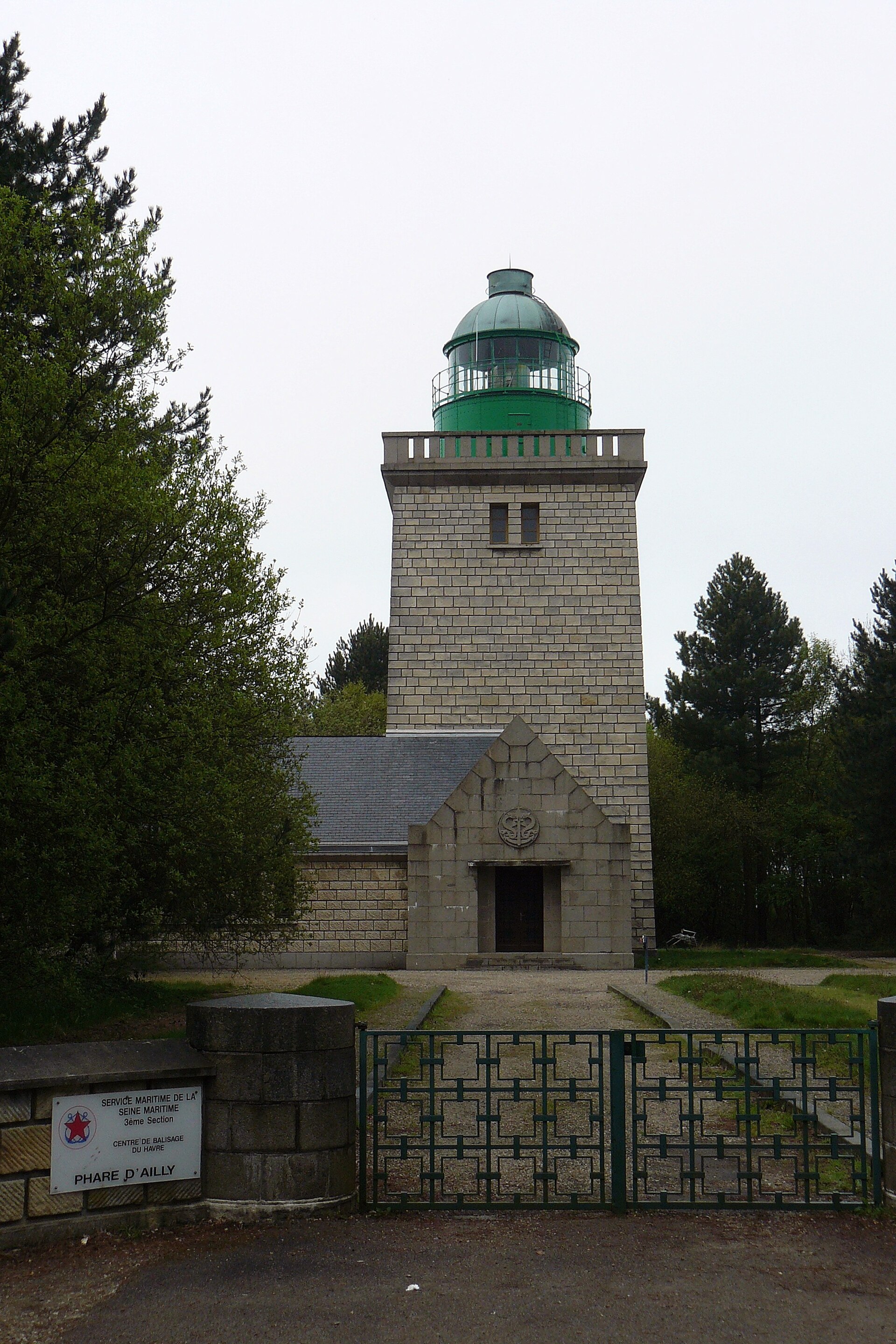
Phare d'Ailly
Sainte-Marguerite-sur-Mer
Phare d'Ailly is a lighthouse perched on top of the cliffs at Sainte-Marguerite-sur-Mer, on Normandy's Alabaster Coast, just a few kilometers west of Dieppe. It's one of the recognizable landmarks of this stretch of French coastline — a tall, square tower visible from far out at sea and from the coastal footpaths above the cliffs. How do you get there? The lighthouse sits right beside the road that runs along the clifftops between Dieppe and Quiberville-sur-Mer. Driving is the most convenient option — there's a parking area nearby, from which it's just a short walk to the lighthouse itself. Alternatively, you can reach it on foot via the GR21 coastal trail, which follows the entire Alabaster Coast. This stretch is popular with hikers, offering sea views on one side and the farmland of the Pays de Caux on the other. What will you see? The current lighthouse is a square tower built from Mignac stone and granite, brought into service in 1958. It stands 24.5 meters tall, with 91 steps leading up to the lantern room. Because it sits on top of the cliff, the light itself is positioned 105 meters above sea level — one of the reasons the view from here is among the most striking on the whole coast. Worth knowing: this is actually the third lighthouse to stand on this spot. The first, a square tower built of white stone, was lit in 1775. It measured 18 meters and originally used an open coal fire as its light source. A second, octagonal tower of grey stone and red brick followed in 1897, entering service in September 1899. Only the third and current structure, built in 1958, has today's square silhouette. The rocks at the foot of the cliff, known as the Roches d'Ailly, posed a hazard to shipping for over two centuries — which is why the site needed increasingly robust lighthouses over time. The lighthouse is automated and not normally open to the public, but the setting alone makes the trip worthwhile: the clifftop panorama, sea wind, and views across the English Channel are impressive whether or not you get inside. In November 2010, the building was listed as a French Historic Monument, recognizing its architectural and landscape value. When should you visit? The lighthouse and the clifftop trail look good year-round, but spring and summer offer the best walking conditions, with longer daylight hours and drier paths. The municipality of Sainte-Marguerite-sur-Mer occasionally opens the lighthouse to visitors, especially during Heritage Days (Journées du Patrimoine) in September — the best chance to see the interior and climb the stairs to the top. Outside those dates, the lighthouse can only be admired from the outside. Frequently asked questions Can you go inside the Phare d'Ailly? The lighthouse operates automatically and isn't normally open to visitors. Access to the interior is mainly possible during occasional events organized by the municipality, including Heritage Days. How tall is the lighthouse? The tower is 24.5 meters tall, with 91 steps leading up to the lantern room. Thanks to its clifftop position, the light itself sits 105 meters above sea level. How many lighthouses have stood on this site? The current 1958 structure is the third lighthouse built here — the first dates from 1775, and the second was built in 1897 and entered service in 1899. Are there other attractions nearby? The lighthouse lies along the GR21 clifftop trail on the Alabaster Coast, close to Dieppe and Quiberville-sur-Mer, making it easy to combine a visit with a cliffside walk and a stop in the surrounding seaside towns.
-
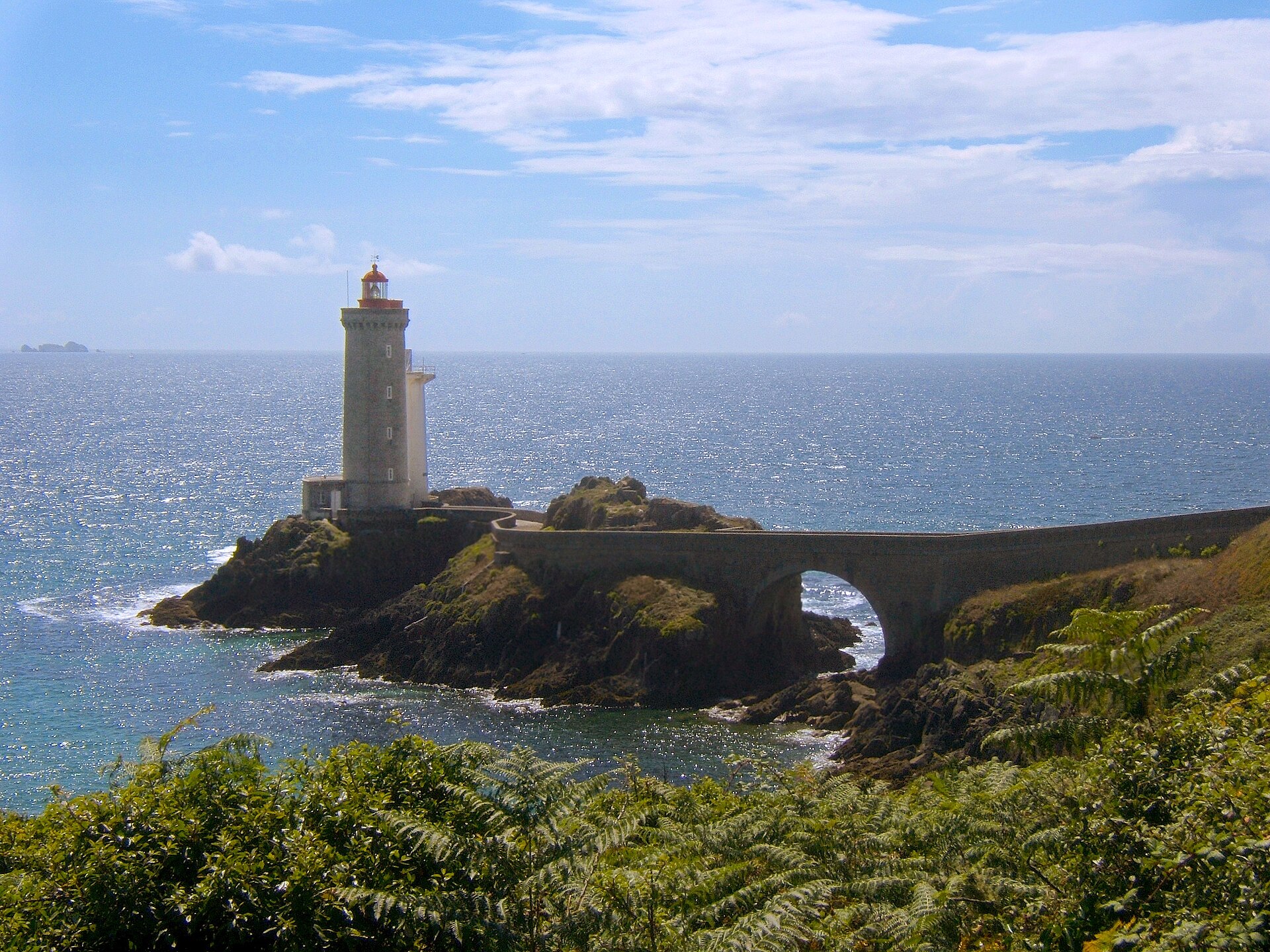
Petit Minou Lighthouse
Plouzané
Petit Minou Lighthouse stands on a rocky point in Plouzané, right at the entrance to the Brest roadstead, next to Fort du Petit Minou. It's one of the most recognizable coastal landmarks near Brest, known mainly to sailors and to visitors drawn to the wild Atlantic scenery of Finistère. How to get there? Plouzané sits on the peninsula just west of Brest, and the easiest way in is by car — the drive from central Brest takes well under half an hour. The lighthouse stands at the end of a short access road that crosses the grounds of the old fort, right above the shoreline. The GR34 coastal trail, Brittany's famous long-distance footpath, runs through this spot too, so walking or cycling in is just as workable — it lets you combine the visit with views over the neighboring coves of the peninsula. There's a parking area near the fort, from which it's a short walk down to the lighthouse itself. What will you see? Petit Minou has a working navigational role: together with the Portzic lighthouse on the opposite side of the bay, it marks the safe channel for ships entering the Brest roadstead. Its most distinctive feature is a red sector light, which warns sailors away from the dangerous shoal of Les Fillettes, one of several submerged rocks in the Goulet de Brest — the narrow strait that leads into the bay. Local sailors have long remembered the warning through a simple rule of thumb: the light turns red exactly when it lines up with Les Fillettes. The lighthouse sits directly in front of Fort du Petit Minou, an old fortification that once guarded the entrance to Brest's naval harbor — together the two structures form one of the most photographed silhouettes on this stretch of coast. From the surrounding rocks, you get a clear view down the whole Goulet de Brest: ships moving in and out of the naval base, and the far shore of the bay beyond. Because the site faces west into the open Atlantic, it's also a popular spot to watch the sunset. When to visit? The Plouzané coastline is accessible year-round, but spring through early autumn gives the best conditions for walking and photography, since longer days make it easy to time a visit around sunset. Summer also tends to bring more shipping traffic through the Goulet de Brest, adding some movement to the scene. Autumn and winter turn the coast wild and windy — conditions that draw in fans of raw Atlantic landscapes, though it's worth dressing for the wind and watching your footing on the wet rocks. Frequently asked questions Can you go inside Petit Minou Lighthouse? No — it's an active navigational aid run by the maritime authorities, so the interior isn't open to visitors. You can view and photograph it from the grounds around the fort. What does the lighthouse's red light mean? The red sector warns ships away from the Les Fillettes shoal in the Goulet de Brest, forming a key part of the navigation system guiding vessels into the Brest roadstead. Is there a fort nearby worth seeing? Yes — the lighthouse stands right next to Fort du Petit Minou, an old fortification guarding the harbor entrance, and the two together make for one shared viewpoint on the coast. Can you walk here along the coast? Yes, the GR34 coastal trail passes through this spot, so it's easy to pair a visit to the lighthouse with a longer walk along the peninsula's cliffs.
-

Cap d'Erquy
Erquy
Cap d'Erquy is a rocky headland in the commune of Erquy, in the Côtes-d'Armor department on Brittany's northern coast. Recognized as part of the Grand Site de France network, it stands out for its pink sandstone cliffs, wild heathland, and three light-sand beaches. How do you get to Cap d'Erquy? The headland sits a few kilometers from the center of Erquy, reachable by car via the D34 road from Saint-Brieuc or Dinan. In summer, parking areas near the beaches serve as the usual starting point for walks around the cape. The coastal GR34 trail also passes through the area, so it's possible to arrive on foot from neighboring spots such as Val-André or Cap Fréhel. What will you see there? The main draw is the pink sandstone cliffs rising 50 to 60 meters above the sea — their distinctive rosy hue stands out best in late-afternoon light. A stretch of the GR34 trail runs along the coast here, linking three wild beaches: Lourtuais, Portuais, and Guen. All three have fine sand and see far fewer visitors than the main beach in Erquy town. A striking feature of the landscape is the Lacs Bleus (Blue Lakes) — flooded former sandstone quarries sitting roughly 40 meters above sea level. Their intense blue color contrasts sharply with the green heathland and the pink rock around them. At the top of the headland stands a stone structure dating from the late 18th century, and nearby is the Corps de Garde des Trois Pierres, a guard house built in 1744 to defend the Breton coast from seaborne attack. From this vantage point, the view stretches across the English Channel, reaching as far as Cap Fréhel on a clear day. Pine groves cover parts of the cape, offering shade during summer walks, while the heathland turns yellow and purple with gorse and heather blooms in spring and summer. When is the best time to visit? Late spring and summer are the best months to visit, when the heathland is in bloom and the beaches are open for swimming. May and June are also good for hiking — fewer crowds than in July and August, with mild temperatures. Autumn and winter bring out the dramatic character of the cliffs, especially during strong Atlantic winds, though the beaches are less inviting at that time of year. What should you know before visiting? The GR34 trail across the headland can be uneven and rocky in places, so sturdy footwear is recommended. Beach parking fills up quickly at the height of summer, so arriving early is advisable. There's little dining infrastructure directly on the cape — the nearest restaurants and cafés are in Erquy itself. Frequently asked questions Can you swim at Cap d'Erquy? Yes, the Lourtuais, Portuais, and Guen beaches are suitable for swimming, though they are wilder and less developed than the main beach in Erquy. How long does the walking loop around the headland take? A popular loop along the cliffs and beaches covers about 7 km and takes 2 to 3 hours at a relaxed pace. What are the Lacs Bleus? They are flooded former sandstone quarries located about 40 meters above sea level, known for their vivid blue color. Is the headland accessible for children and older visitors? The main beaches are easy to reach from the parking areas, but the cliff-top trails can be uneven and require reasonable physical fitness.
-
Aix island lighthouses
Île-d'Aix
The Aix island lighthouses are a pair of twin towers standing by Fort de la Rade on the eastern edge of Île-d'Aix, in the Charente estuary between Île d'Oléron and Île de Ré. Their distinctive red-and-white silhouette is one of the island's landmarks, visible well before the ferry from Fouras even reaches the harbour. Why does the island have two lighthouses instead of one? The first navigational light on this spot was a temporary wooden structure lit in 1821, quickly proving insufficient for the busy shipping lane leading to Rochefort and La Rochelle. Between 1840 and 1841 the first stone tower went up, designed by architect A. Garnier. As maritime traffic kept growing, a second, identical tower was added in 1889 alongside a modernised flashing optical system. In 1906 one of the towers, the western one, was fitted with a red filter, turning the pair into a sector light: white to mark the safe course, red to warn of the danger zone. How does the lighthouse mechanism work? What makes the Aix installation unusual is its use of four catadioptric optical panels rotating around the light source, set in a mercury float basin that reduced friction in the rotating mechanism. The red sector filter had to be positioned at a considerable distance from the optic to mark the hazardous zone with precision. The light's range reaches 35 kilometres, letting ships spot the island well before approaching the coast. Are the lighthouses still in operation? Yes, both towers remain active navigational aids. Automation began in 1975, and the installation is now remotely controlled from the port of La Pallice in La Rochelle, meaning no keeper lives on site anymore. Locals still call the towers "Les Géants de l'île" (the Giants of the Island), a nod to their height and their dominant presence over the flat landscape of Île-d'Aix. Do the lighthouses have heritage protection? On 15 April 2011 both towers were listed as French Historic Monuments (monuments historiques), formally recognising their architectural and technical value as a rare surviving example of 19th-century French lighthouse engineering. Can visitors go inside the towers? The towers are not open for interior visits — they remain working navigational structures under the supervision of maritime authorities, with access reserved for technical staff. Visitors can, however, walk right up to the base of the lighthouses from the Fort de la Rade side and admire the structure from outside, with the sea and the fort's fortifications as a backdrop. How do you get to the lighthouses on Île-d'Aix? Île-d'Aix is a car-free island reached by ferry from Fouras, a crossing of roughly 20 to 30 minutes. The lighthouses stand close to Fort de la Rade, within easy walking distance of the island's main harbour — the walk usually takes about fifteen minutes, or less by bicycle, which can be rented on the island. Frequently asked questions Why does Île-d'Aix have two lighthouse towers instead of one? The second tower was built in 1889 when growing maritime traffic required an upgraded light system. Together the twin towers form a sector light: one marks the safe course, while the other, fitted with a red filter since 1906, warns of the danger zone. How far can the light be seen? The light's range reaches about 35 kilometres, making it one of the key navigational aids in the Charente estuary between Île d'Oléron and Île de Ré. Are the lighthouses still staffed by keepers? No. Since automation began in 1975, the lighthouses have been remotely controlled from La Pallice in La Rochelle and require no on-site staff. Can the towers be visited from the inside? No, the interiors are closed to the public. They can still be admired from the outside near Fort de la Rade, which is a popular stop on any tour of the island.
-
Le Tréport lighthouse
Le Tréport
Le Tréport lighthouse (Phare du Tréport) stands at the tip of the western jetty of the port in Le Tréport, in the Seine-Maritime department, right on the border between Normandy and Picardy. Where exactly does the lighthouse stand? The lighthouse rises at the very end of the western breakwater, precisely where the Bresle river flows into the English Channel. The Bresle forms the natural boundary between Normandy and the Hauts-de-France region, so the lighthouse effectively marks the meeting point of two provinces. Its job is to guide fishing boats and leisure craft safely into the harbour of Le Tréport, one of the busier fishing ports along this stretch of the Channel coast. What does the lighthouse look like? It's a slim, cylindrical tower standing 14 metres tall, painted in white and green bands — a colour scheme commonly used on French harbour-entrance beacons. A halogen lamp sits at the top, casting a beam visible from up to 20 nautical miles away, roughly 37 kilometres. That range lets approaching vessels spot the harbour entrance long before they're close to shore. How old is the lighthouse and what's its history? The current tower was built in 1844 to mark the approach to the port and the mouth of the canal leading to the town of Eu. It wasn't the first light on this spot, though: a surviving painting depicting Queen Victoria's arrival in Le Tréport shows a lighthouse already standing there in 1843, and some sources trace a navigational marker at this location back even further, possibly before 1807. In other words, Le Tréport has needed a light to guide ships into its harbour for well over two centuries, and today's white-and-green tower simply continues that long tradition. Can visitors go inside? No — the lighthouse is fully automated and closed to the public; there's no access to the interior or the top. It remains, however, a distinctive landmark for anyone walking the quayside and jetty. The view of the tower, especially at sunset when its white-and-green silhouette stands out against the sky over the Bresle estuary, is one of the more photographed spots for visitors to Le Tréport. How do you get to the lighthouse? The lighthouse sits at the end of the western harbour jetty, reached via a waterfront promenade. It's a short, easy walk from the centre of Le Tréport, suitable for most visitors without any special preparation. Bringing a camera is worthwhile: from the jetty you get not only a close view of the lighthouse itself but also a panorama of the chalk cliffs toward Normandy and of the town's beach and seafront. Frequently asked questions Is the Le Tréport lighthouse open to visitors? No. It's fully automated, and there's no public access to the tower or its top. You can, however, view it freely from the outside while walking along the jetty. How tall is the lighthouse and how far does its light reach? The tower stands 14 metres high, and its halogen light is visible from up to 20 nautical miles away, or about 37 kilometres. How long has there been a lighthouse in Le Tréport? The current structure dates from 1844, but a navigational light existed here earlier — confirmed by sources from 1843, with some accounts suggesting a marker on this spot predates even 1807. Why is the lighthouse located exactly where it is? It stands at the tip of the western jetty, right where the Bresle river meets the English Channel — the natural entrance to Le Tréport's harbour, which the lighthouse marks and helps navigate safely.
-
Phare de Cap Couronne
Martigues
Phare de Cap Couronne is a lighthouse standing on the Cap Couronne headland in the municipality of Martigues, in the Bouches-du-Rhône department near Marseille. It marks the eastern entrance to the Gulf of Fos and is the only lighthouse along the entire Côte Bleue coastline, between the small port of Carro and the L'Estaque district. Where exactly does the lighthouse stand? The lighthouse rises above the village of La Couronne, on a low, rocky headland jutting into the Mediterranean. The current tower is a slightly tapered cone built of reinforced concrete, painted white with a red top — a colour scheme typically used on French lighthouses that warn ships away from rocky, hazardous approaches. The structure stands 33 metres tall and carries a radar antenna. What is the history behind this lighthouse? The first lighthouse on this spot was built in 1867 as a so-called maison-phare — a keeper's dwelling combined with a low, square tower just 11.60 metres high. It originally showed an eclipse light flashing every 20 seconds. Over the following decades the light characteristic changed several times: to a red flash every 5 seconds in 1904, every 2.5 seconds in 1937, and every 3 seconds in 1955. The old building eventually fell into disrepair and was demolished in 1963, after a taller replacement had already taken over its role. The current lighthouse has been in service since 1960. It is a much taller and sturdier concrete tower than its predecessor, shaped as a truncated cone. Its red light flashes every 3 seconds and can be seen from roughly 20 nautical miles away, close to 37 kilometres. The lighthouse was automated in 2001, so it no longer needs a resident keeper. Can visitors climb the lighthouse or get a close look? Since automation, the lighthouse has not been open to the public — there is no access to the interior or to a viewing platform at the top. Visitors typically admire it from outside, whether from the nearby beach, the coastal path, or a boat cruising along the Côte Bleue. The headland itself is a popular spot for walking, sunset photography, and simply watching the sea — the rocky shoreline and open view over the Gulf of Fos are worth the trip whether or not the light is flashing. What else is worth seeing nearby? Cap Couronne sits within the municipality of Martigues, often nicknamed the "Venice of Provence" for the canals and bridges running through its historic centre. Close to the lighthouse stands the sémaphore de la Couronne, an 1887 signal station once used for maritime surveillance. The Côte Bleue coastline where the lighthouse stands is known for its rocky coves, low cliffs, and coastal walking paths leading toward Carro to the west and L'Estaque, a Marseille district, to the east. It makes a good base for travellers looking for a quieter alternative to central Marseille while staying close to the city. Frequently asked questions Can you climb to the top of the Cap Couronne lighthouse? No. The lighthouse has been automated since 2001 and is not open to visitors — there is no access to the interior or to any viewing point at the top. How tall is the lighthouse and how far does its light reach? The current tower stands 33 metres tall, and its red light, flashing every 3 seconds, is visible from about 20 nautical miles away, nearly 37 kilometres. Is this the only lighthouse on this stretch of coast? Yes. Phare de Cap Couronne is the only lighthouse along the whole Côte Bleue, between the port of Carro and the L'Estaque district of Marseille. Was there an earlier building on the site of today's lighthouse? Yes. From 1867 to 1963, a shorter keeper's-house lighthouse (11.60 m) stood here. It was demolished after years of decay, once the taller 1960 tower had taken over its function.
-
"La Fenêtre" lighthouse
Cancale
The "La Fenêtre" lighthouse is a small but distinctive maritime landmark in Cancale, the Breton oyster town in the Ille-et-Vilaine department. It stands at the mouth of Port de la Houle, guarding the entrance to the bay that stretches between Cancale and Mont-Saint-Michel, and has guided fishing boats and pleasure craft into harbor for over a century and a half. Where does the name "La Fenêtre" come from? The lighthouse rises from a rock formation known locally as "rocher de la Fenêtre" — literally "Window Rock." The nickname comes from this rock, not from any window-like feature of the tower itself. Locals in Cancale use this informal name far more often than the official designation "Phare de la Houle," under which the lighthouse also appears in maritime records. When was it built, and why here? Construction dates back to the mid-19th century, when Port de la Houle was undergoing rapid growth thanks to cod fishing on the banks of Newfoundland, an activity Cancale sailors took up around 1850. The rising volume of boat traffic through the port's narrow entrance called for reliable navigational marking. In 1858, France's Corps of Bridges and Roads (Corps des Ponts et Chaussées) carried out a study for the project, and the lighthouse itself went up in 1862. It was lit for the first time on 1 March 1863, and it has marked the harbor entrance ever since. What does the lighthouse look like? It is a cylindrical stone tower roughly 11 meters tall, topped with a gallery and lantern room — a compact, functional design typical of small harbor lighthouses from that era. The tower is not open to visitors inside, but it is easily seen from the quayside and from the nearby jetty (jetée de la Fenêtre), which also offers wide views across the bay toward Mont-Saint-Michel. What should visitors know before stopping by? The lighthouse sits right next to Port de la Houle, Cancale's historic fishing harbor where the town's famous oysters are still landed today. Walking along the quay, with the tower and fishing boats in view, is one of the most pleasant ways to take in the town's maritime character. The best photo spot is the jetty at the harbor entrance, particularly at high tide, when the water rises close to the base of the rock the tower sits on. The lighthouse remains an active navigational aid managed by French maritime authorities, so there is no interior tour on offer — its role is functional rather than museum-like. Even so, it is one of the most photographed spots in Cancale and a natural landmark for anyone strolling the harborfront. Frequently Asked Questions Can visitors go inside the "La Fenêtre" lighthouse? No, the lighthouse is an active navigational aid and is not open to the public. It can be freely viewed and photographed from the quay and the harbor jetty, however. Where does the name "La Fenêtre" come from? It refers to the "rocher de la Fenêtre," the rock the lighthouse stands on, rather than to any feature of the tower itself. When was the lighthouse built? It was built in 1862 and first lit on 1 March 1863, in response to growing boat traffic at Port de la Houle driven by cod fishing off Newfoundland. Does the lighthouse have another name? Yes, it is also officially known as "Phare de la Houle," after the harbor it lights.
-
Richelieu lighthouse
La Rochelle
Richelieu Lighthouse stands at the entrance to the channel leading into La Rochelle's old harbor and the Port des Minimes, close to the Saint-Nicolas and Chaîne towers. The red-and-black tower is no random addition to the city's skyline — it marks the northern end of the Richelieu dike, one of the most significant structures in the city's history. Why is the lighthouse named after Cardinal Richelieu? The name comes from Cardinal Richelieu, who during the siege of La Rochelle in 1627–1628 ordered the construction of a massive dike across the bay. The goal was to cut the Protestant city off from seaborne supplies, since La Rochelle was counting on relief from an English fleet, and the dike was meant to block ships from ever reaching the port. The structure was decisive in the city's eventual surrender and played a central role in the fall of this Huguenot stronghold. Remnants of the dike are still visible today at low tide — two arms extending from the northern and southern shores, leaving a gap of roughly 100 meters between their tips. The Richelieu lighthouse sits precisely at the tip of the northern arm, marking for sailors both the end of the historic dike and the entrance to the harbor channel. What does the lighthouse look like and what does it do today? The tower stands 17 meters tall, and its light carries 9 nautical miles, making it an important landmark for vessels approaching La Rochelle. Its distinctive red-and-black paint scheme sets it apart from other lighthouses in the harbor and helps helmsmen identify it from a distance. Since 2001 the lighthouse has been equipped with a fog signal that assists navigation in poor visibility — not every historic structure on this stretch of the Atlantic coast still carries out an active maritime safety role, and Richelieu is a clear example of one that does. Where exactly is it, and how does it fit with the rest of the old port? The lighthouse stands at the tip of the Richelieu dike, right at the entrance to the channel connecting the ocean to the old port and the Port des Minimes. It's a natural stop on a harbor walk — from here you can also see the medieval watchtowers (Saint-Nicolas, Chaîne, and the Lantern Tower) that have guarded the port entrance for centuries. Walking along the dike at low tide gives a real sense of the scale of this 17th-century military engineering project that helped decide the city's fate. Worth noting: La Rochelle also has another, much newer maritime structure — a replica lighthouse at Port des Minimes known as the "Phare du Bout du Monde" (Lighthouse at the End of the World). That is a separate landmark with no historical link to the Richelieu dike, and should not be confused with the genuine historic lighthouse described here. Frequently asked questions What is the Richelieu dike and why was it built? It's a structure built in 1627–1628 on the orders of Cardinal Richelieu during the siege of La Rochelle, meant to cut the city off from seaborne supplies and block relief from the English fleet. How tall is the lighthouse and how far does its light reach? The tower is 17 meters tall and its light has a range of 9 nautical miles. Is the Richelieu lighthouse still active? Yes, it still serves an active navigational role and has been fitted with a fog signal since 2001 to assist ships in low visibility. What else is worth seeing near the lighthouse? Nearby stand the old port's historic towers — Saint-Nicolas, Chaîne, and the Lantern Tower — and at low tide you can still see the remains of the 17th-century dike.
-
Phare de la Pointe des Chats
Groix
Phare de la Pointe des Chats is a lighthouse on the southeastern tip of Île de Groix in Brittany, standing right at the water's edge on a rocky point flanked by a reef that stretches more than a kilometer out to sea. Where exactly is this lighthouse, and why here? Pointe des Chats is the southeasternmost point of Île de Groix, in the Morbihan department. The name comes from how islanders long described the shape of the rocks scattered across the point — locals simply called it the "cats' point." The lighthouse sits directly on granite bedrock, close enough to the sea that storm spray reaches its base. The real reason it was built here is the long, rocky underwater ledge running out from the point, which caused repeated shipwrecks over the decades and pushed the maritime authorities to finally mark the danger with a light. When was it built, and what does it look like? The lighthouse was constructed in the 1890s on the site of a former coastal defense battery, and it entered service on 15 October 1898. The tower stands roughly 15 meters tall, with its light positioned just under 18 meters above sea level — noticeably shorter and more compact than Brittany's grand offshore lighthouses. That's by design: this light was meant to warn ships away from a shallow hazard right at the coastline, not to guide vessels from far out at sea. The structure keeps the plain, functional style typical of French warning lighthouses from the late 19th century — an unadorned stone tower built for effectiveness rather than grandeur. What else is worth knowing about the point itself? Pointe des Chats is more than just a lighthouse site — the whole headland is a protected geological area prized by rock and mineral enthusiasts. Its rocks contain garnet, micaschist, glaucophane, and epidote, an unusually concentrated mix of minerals for such a small stretch of coastline, which draws geologists and collectors to the site. In 2017, archaeologists uncovered a megalithic burial monument with a funerary chamber near the lighthouse, evidence that the point was already significant to the island's inhabitants back in the megalithic era, long before any lighthouse stood here. What has changed at the lighthouse recently? Since 2021 the lighthouse has belonged to the Conservatoire du littoral, the French coastal conservation body. The building underwent a thorough restoration: the stone walls were repointed, the interior was completely renovated, the rainwater cistern was restored to working order, and the surrounding grounds were tidied up. The lighthouse also gained a new purpose — the former keeper's quarters have been converted into overnight accommodation, meaning visitors can now actually spend a night inside it, a rare option among French lighthouses. How do you get to Pointe des Chats? Île de Groix is reached by ferry from Lorient, a crossing of around 45 minutes. From the harbor in Groix, the lighthouse at Pointe des Chats is reachable on foot or by bike — it's one of the island's popular coastal walking routes, running along the shoreline with open ocean views the whole way. Frequently asked questions Can you visit the inside of Phare de la Pointe des Chats? Since its restoration, the lighthouse operates as overnight accommodation managed through the Conservatoire du littoral, so interior access is mainly for guests who book a stay rather than for casual guided visits. Why is it called "des Chats" (of the cats)? The name comes from the local nickname islanders gave the point because of the distinctive shape of the rocks scattered across it, not from any literal connection to cats. What makes the rocks around the lighthouse special? The headland is a protected geological site with an unusual mix of minerals — garnet, micaschist, glaucophane, and epidote — making it a point of interest for geologists and anyone curious about the island's natural history. Is the lighthouse still an active navigational aid? Yes. It has operated continuously since 1898 and still warns ships away from the rocky reef extending from the southeastern coast of Île de Groix.
-
Phare du Sénéquet
Gouville-sur-Mer
Phare du Sénéquet is a lighthouse standing alone on a rock off the coast of Gouville-sur-Mer, in the Manche department of Normandy, France. It rises roughly 3.8 km from the shoreline on the flat, partly tide-covered Sénéquet rock, and is one of the recognisable landmarks of this stretch of the Norman coast. How did a lighthouse end up on this rock? Before it became a full lighthouse, the Sénéquet rock carried only a simple, unlit signal tower — a daytime marker for sailors, but with no light to warn ships at night. That changed after a shipwreck: on 14 December 1858, in thick fog, the paddle steamer aviso L'Antilope ran aground on the rocks while heading to assist a merchant vessel in distress off Carteret. The wreck was the direct trigger for the decision to turn the tower into a proper lighthouse. When did the light first shine? The original tower stood 12 metres tall. In 1860 it was raised by another 8 metres, creating a three-level structure, two of which were fitted out as living quarters for the keepers. The lighthouse entered service on 20 February 1861, from then on warning ships away from the dangerous rock and helping guide shipping along this section of the Normandy coast. What does the lighthouse look like today? Phare du Sénéquet is a white tower of exposed stone, topped with a black base and a black lantern housing — a contrasting colour scheme typical of French lighthouses, designed to make the structure easy to identify by day. In the early 20th century a breakwater and a landing stage were added, making it easier for boats to come alongside; before that, the strong currents and tides typical of this part of Normandy made access difficult. Is the lighthouse still in operation? The lighthouse was electrified and automated in 1937, ending the need for a permanent keeper on site. It underwent a further upgrade in 1981 and now runs automatically, powered by a small wind generator fitted to the structure. Phare du Sénéquet is listed in the French heritage inventory, recognising its value as a piece of the region's maritime history. How can visitors see the lighthouse from Gouville-sur-Mer? Because it stands on an exposed rock several kilometres offshore, the best way to see the lighthouse is from the beach at Gouville-sur-Mer or from nearby viewpoints along the coast — on a clear day and at low tide, its silhouette stands out sharply against the horizon. It's a popular subject for photographers visiting the Côte de Manche, especially at sunset, when the white tower contrasts with the darkening sky and sea. The lighthouse itself is not open to visitors — it stands on a rock surrounded by water and serves a purely navigational function, with no on-site tourist facilities. Even so, it remains an important part of the local landscape and maritime history, a reminder of how dangerous these waters off Gouville-sur-Mer once were for ships without proper markers. Frequently Asked Questions Where exactly is Phare du Sénéquet located? The lighthouse stands on the Sénéquet rock, about 3.8 km off the coast of Gouville-sur-Mer, in the Manche department of Normandy. Why was the lighthouse built at this spot? It followed the wreck of the steamer L'Antilope on the rocks in fog in December 1858 — before that, only an unlit signal tower marked the spot. When did the lighthouse start operating? It entered service on 20 February 1861, after the original 12-metre tower was raised by an extra 8 metres. Can visitors go inside the lighthouse? No — it stands on an isolated, partly tide-covered rock and runs automatically, with no visitor access to the interior. It can only be viewed from the shore or from the water.
-
Phare du Grand Léjon
Phare du Grand Léjon is a solitary lighthouse standing on a rock at the entrance to the Bay of Saint-Brieuc, on the coast of Côtes-d'Armor in Brittany. It rises at the southern edge of the Grand Léjon rocky plateau, roughly 16.5 km offshore from Saint-Quay-Portrieux. It belongs to no town or village — it stands in open water, visible from the coast as a distinctive landmark on the horizon. Where exactly is the Grand Léjon lighthouse? The lighthouse sits on a rock protruding from the sea at the entrance to the Bay of Saint-Brieuc, between Erquy and the waters leading toward Île de Bréhat. It is one of several isolated offshore lighthouses guarding this stretch of the Breton coast, an area known for strong currents and numerous submerged rocks that have long made navigation hazardous. When was the lighthouse built? Construction of the tower began in 1859 and was completed in 1862. Building on a remote rock surrounded by open sea was extremely difficult — during a storm in 1860, a wave over five meters high capsized one of the boats supporting the construction site. Two brothers from the Bougeard family, aged 30 and 15, drowned in the accident. The tragedy illustrates the human cost of building lighthouses on France's exposed coastal rocks in the 19th century. When did the light first shine? From the outset, the tower was designed so it could later be raised and fitted with a light source. Following a structural study in 1877 that confirmed the tower's solidity, engineers decided to heighten it and install a 4th-order white flashing light. The light was first lit in 1882 — twenty years after the tower itself was finished. How has the lighthouse changed over time? In 1954, the Commission of Lighthouses decided to convert Grand Léjon into an unguarded gas-powered light, ending permanent staffing on site. The structure takes the form of a truncated conical cylinder, topped by a platform carrying the lighting apparatus, enclosed within a glazed lantern room. This shape, typical of lighthouses built on isolated rocks, was designed to minimize resistance against waves and wind. Can visitors go inside the lighthouse? Like most lighthouses standing on isolated, water-surrounded rocks, Grand Léjon is not open for visits inside — reaching it requires a boat, and sea conditions around the site can be demanding. It can, however, be observed from boat trips around the Bay of Saint-Brieuc or from viewpoints along the coast near Saint-Quay-Portrieux and Erquy, from where its distinctive silhouette is visible on the horizon in good weather. Frequently asked questions Which town is the Grand Léjon lighthouse part of? The lighthouse does not belong to any town — it stands on a rock in open water at the entrance to the Bay of Saint-Brieuc, in the Côtes-d'Armor department. How far offshore is the lighthouse? It sits roughly 16.5 km from the coast, off Saint-Quay-Portrieux, at the southern edge of the Grand Léjon rocky plateau. When did the lighthouse become operational? The tower was built between 1859 and 1862, but the light itself was not lit until 1882, after the structure was raised and fitted with a lighting apparatus. Is the lighthouse still staffed by a keeper? No. Since 1954 it has operated as an unattended automatic light, with no permanent keeper on site.
-
Phare de Grave
Le Verdon-sur-Mer
Phare de Grave is a lighthouse standing at the tip of Pointe de Grave in Le Verdon-sur-Mer, exactly where the Gironde estuary meets the Atlantic Ocean. For nearly two centuries the tower has guided ships into the river mouth and remains one of the defining landmarks of the northern Médoc peninsula. Where does the lighthouse stand, and why here? Pointe de Grave marks the northernmost tip of the Médoc peninsula, the exact point where the Gironde's waters give way to the open ocean. This is a critical spot for shipping: sandbanks and strong currents at the river mouth have long demanded precise navigational markers. The lighthouse works in tandem with the more famous Phare de Cordouan, located a few kilometers offshore, together guiding vessels along the safe channel into the estuary. How has the lighthouse's history unfolded? The first makeshift light appeared here in 1823 — a simple reflector mounted on a wooden scaffold while a proper masonry tower was being planned. Construction of the stone tower began in 1825, and in 1827 a white flashing light was installed atop the 18-meter structure. Erosion from the sea proved too aggressive, though: by 1829 the light had to be moved to a temporary post because the tower's foundations were too exposed to wave action. It wasn't until 1860 that the third and definitive version of the lighthouse was built — the one that, with later modernizations, still shines today. Remarkably, this structure was completed in just nine months, a genuine feat of nineteenth-century maritime engineering. The lighthouse was electrified in 1937 and fully automated in 1955, meaning it no longer requires a resident keeper. On November 6, 2009, the site was officially listed as a French historical monument, recognizing both its architectural and heritage value. What does the lighthouse look like, and how is it built? Phare de Grave is a square tower built from smooth-cut masonry, painted white, with visible stone corner quoins accentuating its edges. The top of the tower is painted black — a classic color scheme used across French lighthouses to make the structure easier to identify by day. The tower is attached to a U-shaped building constructed using the same masonry technique. The structure's total height above sea level is 34.60 meters, the tower itself measures 27 meters, and the focal plane of the light sits at 25 meters. A staircase of 107 steps leads up to the viewing platform that surrounds the lantern. What should visitors know about the lighthouse and its surroundings? Pointe de Grave is a popular vantage point over the Gironde estuary, offering views of the ocean, passing ferries and ships, and the neighboring Phare de Cordouan, one of the oldest working lighthouses in Europe. The surrounding area falls under protection managed by the Conservatoire du littoral, preserving natural dunes and a distinctive coastal landscape. It's a good spot for walking, birdwatching, and landscape photography, especially at dusk when the lighthouse's beam begins its work. Frequently asked questions Can visitors climb to the top of Phare de Grave? Access to the tower's interior and viewing platform depends on locally set visiting rules — it's worth checking with the local tourist office or on-site signage before planning a visit. How does Phare de Grave differ from Phare de Cordouan? Phare de Cordouan stands on a rock right at the mouth of the Gironde and is considerably older, regarded as one of the oldest lighthouses in Europe. Phare de Grave sits on land, at the tip of Pointe de Grave, and serves as a complementary landmark for shipping. When was the lighthouse recognized as a historical monument? Phare de Grave was listed as a French historical monument on November 6, 2009. Is the lighthouse still an active navigational aid? Yes, it remains in operation today. It was automated in 1955 and no longer needs an on-site keeper, but it continues to guide ships entering the Gironde estuary.
-
Vieux Phare des Baleines
Le Gillieux
Vieux Phare des Baleines rises on the Pointe des Baleines in Saint-Clément-des-Baleines, at the western tip of Île de Ré, within the Le Gillieux area. It is the older of two lighthouses standing on this headland — a former watchtower that guided ships for well over a century and a half, and today works as a viewpoint and small history exhibit rather than an active aid to navigation. When and why was the old tower built? The project began under Colbert, minister to Louis XIV, who in 1669 ordered a lighthouse-tower raised on the Baleines point. Construction followed the plans of engineer Augier and was completed in 1682. Its purpose was twofold: to steer ships away from the dangerous rocks offshore and to protect access to the naval port of Rochefort, one of France's key Atlantic bases. From 1682 the tower operated as a navigational light and a watch post over passing maritime traffic, remaining in service for well over a hundred years. Where does the name "Baleines" come from? The headland has carried this name for centuries because whales and sperm whales repeatedly beached along this stretch of coast, which is exposed to strong Atlantic currents. The phenomenon happened often enough that "Baleines" (whales) stuck — first to the point itself, then to the lighthouses built on it. Why was a new lighthouse built right next to it? In the 19th century the old tower was fitted with parabolic reflectors in an attempt to extend its range, but this proved insufficient as shipping traffic grew and safety requirements tightened. Raising the existing structure was judged too costly, so a completely new lighthouse was commissioned instead — its lens apparatus was lit for the first time in 1854, alongside a third-order light on the Haut Banc du Nord. From that point the old tower lost its navigational role to the taller, modern Phare des Baleines that now stands beside it. What does the old tower offer visitors today? Retirement from active service did not mean the end of the old lighthouse's story. On June 22, 1904 it was listed as a monument historique, placing it under formal heritage protection in France. Also known locally as the Tour Vauban, the tower is open to visitors, who can climb to the top for views over the headland, the neighboring active lighthouse, and the open Atlantic. A small exhibition beside the tower covers the site's history — its construction, the shipwrecks that once plagued this coast, and the lighthouse's role in local maritime traffic. It ranks among the oldest surviving lighthouse towers in France, which alone makes it worth a stop for anyone interested in maritime heritage. How do you get there? The Pointe des Baleines sits at the very tip of Île de Ré, reached by bridge from the mainland. From the center of Saint-Clément-des-Baleines, a short drive or a walking and cycling path along the dunes leads straight to the site, which most visitors combine with a stop at the newer, still-active Phare des Baleines standing next door. Frequently asked questions Is the Vieux Phare des Baleines still an active lighthouse? No. It stopped guiding ships after 1854, when a taller replacement lighthouse was lit right beside it. Today the old tower is a heritage site open to visitors rather than a working aid to navigation. Why is it called "Baleines"? Because whales and sperm whales regularly beached on this stretch of the Île de Ré coastline for centuries — the name stuck to the headland and to both lighthouses built on it. Can you climb the old tower? Yes, it is open to the public and leads to a viewing point overlooking the headland, the ocean, and the newer lighthouse next door. Is the old lighthouse a protected monument? Yes, it was listed as a monument historique on June 22, 1904, making it one of France's protected pieces of maritime heritage.
Earn badges for the places you visit
Download NextOnTrip, discover new places and check off your trails.