About this place
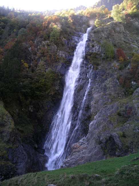
Aschlbach Waterfall (also Cascata Gargazonne or Cascata Rio Eschio) near Gargazon in South Tyrol is the most impressive cascade on the Aschlerbach stream — known locally as Gargazoner Bach or Rio Eschio — a watercourse that has served as a regional border marker for over two thousand years.
A stream that drew borders
The Aschlerbach is historically remarkable: it once separated the Roman provinces of Raetia I and Raetia II, later marked the southern edge of the County of Vinschgau and the Bishopric of Chur, and at the start of the 19th century formed the boundary between Bavaria and the Kingdom of Italy. Today it divides the districts of Burggrafenamt and Salten-Schlern. This unbroken history as a border stream is why Gargazon — a village strung along the main road between Merano and Bolzano — has always been considered a frontier settlement.
The trail to the falls
The Aschlerbach produces up to ten cascades along its course. The most accessible drops roughly 40 metres over a steep rocky ledge near the ruin of Kröllturm, a medieval defensive tower above the valley.
The hike begins in Gargazon village near the restaurant Turmwirt, follows the main road south for about 15 minutes, then turns east onto a path climbing through the Panoramaweg — a scenic route passing the upper houses of Gargazon. The well-marked Burgweg then leads up to the Kröllturm ruin and the nearby waterfall. The round-trip distance is 2.3 km with 150 metres of elevation gain; allow around 1 hour 30 minutes.
When to visit
Spring and early summer offer the strongest flow after snowmelt from the surrounding mountains and are the recommended season for this waterfall. Note that the gorge can become dangerous during heavy rainfall due to sudden rises in water level.
Frequently asked questions
How many waterfalls does the Aschlerbach have? The stream produces up to ten cascades along its length. The one near the Kröllturm ruin is the most accessible and the most spectacular.
What is the Kröllturm? The ruin of a medieval defensive tower standing close to the main waterfall. Reaching it requires an additional 10 minutes of climbing from the main trail — and it can be visited along the same excursion.
How difficult is the hike? The route is 2.3 km long with 150 metres of elevation gain, suitable for most reasonably fit walkers. Exercise caution near the gorge after heavy rain.
How do I get to the trailhead? Gargazon sits on the main road between Merano and Bolzano. Parking is available near the village church and at the Turmwirt restaurant.
Nearby places

Earn badges for the places you visit
Download NextOnTrip, discover new places and check off your trails.