Monuments in the United Kingdom
A guide to 579 Monuments in the United Kingdom — with descriptions, photos and traveler visits from the NextOnTrip community. Locations spread across 331 cities and towns. Most visited by the community: Chiswick House, Backwell House, Westbury On Trym War Memorial.
-
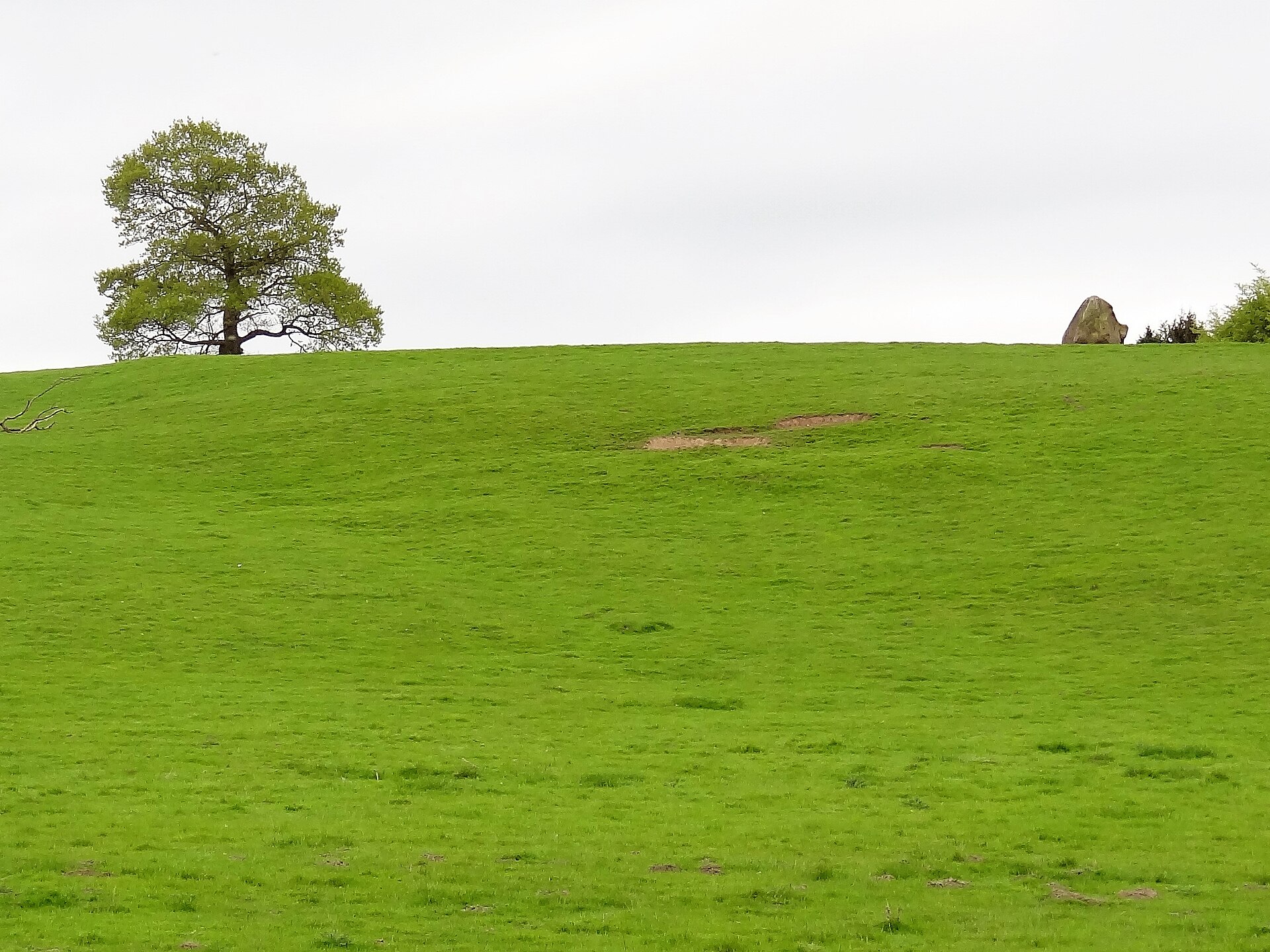
Carved rock known as the Grey Stone in Grey Stone Pasture, Harewood Park, 370m south east of New Bridge
Leeds
The Grey Stone in Harewood Park is a huge gritstone boulder covered in prehistoric carvings, sitting in a pasture inside Harewood Park, north of Leeds in West Yorkshire. Its formal designation is "Carved rock known as the Grey Stone in Grey Stone Pasture, Harewood Park, 370m south east of New Bridge". It is a petroglyph protected as a scheduled archaeological monument in England. What is the Grey Stone? The Grey Stone is a lone block of rock measuring roughly 4.2 x 2.4 x 2.7 metres, set on a low ridge within Grey Stone Pasture. Its surface carries marks cut in the Neolithic or Bronze Age. Carvings of this kind on natural rock are known as rock art, and northern England has many examples. What can you see on the rock? Several faces of the boulder are carved. The most distinctive is a small vertical face bearing six concentric rings with no central cup, the hollow normally found in this type of motif. Heritage records also describe a north face with a larger central circle surrounded by smaller ones, compared to a Celtic shield. Researchers of rock art note as many as 18 further cup marks across the surface, catalogued in Boughey and Vickerman's 2003 survey. How old are the carvings? Historic England links the carvings to roughly 2000 to 1500 BC, citing worked flints and an axe found nearby. Rock art of this type is generally placed in the Late Neolithic and Bronze Age. One writer suggests that rings lacking a central cup may be later than examples found on the moors, but that is an opinion rather than established fact. Where does the name come from? "Grey Stone" is a fairly common name in northern England, often given to boulders that may carry cup-and-ring markings. Some authors also connect this stone with the origin of the name Harewood itself, though that remains a suggestion. Visiting tips The rock stands in Harewood Park, about 370 metres south east of New Bridge. The land is part of the private estate around Harewood House, so check current access rules and walking routes before you go. The spot is quiet, with no visitor facilities. Wear sturdy footwear, as the pasture can be muddy, and aim for low sunlight in the morning or late afternoon, when carvings show up best. Frequently asked questions Is the Grey Stone protected? Yes. It is listed by Historic England as a scheduled archaeological monument, so do not touch it with tools, take rubbings or mark it in any way. How old are the carvings? Historic England dates them to around 2000 to 1500 BC, the Late Neolithic or early Bronze Age. Where exactly is it? In Harewood, in the Leeds district, at about 53.883 N, 1.523 W. What do the concentric rings mean? Nobody knows for certain. Researchers usually suggest ritual or territorial symbolism, but firm evidence is lacking. Is it good for a short walk? Yes, if you enjoy archaeology and parkland landscapes. Combine it with a visit to Harewood House and the surrounding paths.
-
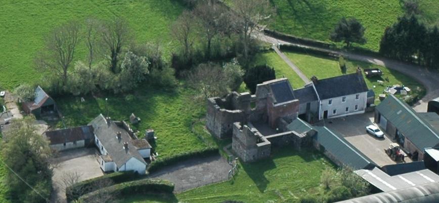
Mountjoy Castle
Mid-Ulster District Council
Mountjoy Castle is a ruined fortified house in County Tyrone, Northern Ireland, standing on a hill above the western shore of Lough Neagh. It lies near the village of Brockagh, in the townland of Magheralamfield, and belongs to the Mid-Ulster District Council area. It is a small but atmospheric stop for anyone interested in the turbulent decades when Ulster passed from Gaelic lordship to English rule. What is Mountjoy Castle? The castle is a fortified house from the early 17th century, built in the aftermath of the Nine Years War. It takes its name from Charles Blount, Lord Mountjoy, the Lord Deputy of Ireland, whose campaign in Ulster led the English to build a fort in this area in 1602. That earlier earthwork is a separate structure: it straddles the modern Mountjoy Road (B161) and the lane leading up to the surviving castle. The stone building that visitors see today is generally dated to shortly after 1605, and is thought to be the fortification reported in 1611 as built beside the old fort. What does it look like? The lower walls are of stone with dressed corner blocks, while the upper parts are of brick, a mix that was fashionable for plantation-era buildings. The central block is flanked by four angle towers with gun-loops, which show that it was designed to be defended as well as lived in. Only three of the four towers can currently be entered by visitors. Why is it historically important? The castle sits in a strategic position overlooking Lough Neagh, a major route and landmark in Ulster. During the Irish Rebellion of 1641 it was captured by forces loyal to Felim O'Neill of Kinard, under the command of Turlough Gruama O'Quinn. It was held by Gaelic forces until the defeat of Turlough O'Neill by General Monro in 1643. One account says it was dismantled on parliamentary orders in 1648, and it has stood as a ruin ever since. Can I visit? Mountjoy Castle is a State Care Historic Monument. Entry is free, although access can be restricted when conservation work is under way, so it is worth checking before you travel. Archaeologists from Queen's University Belfast have also carried out community excavations in the Brockagh area, focused on the earlier fort. Frequently asked questions Where is Mountjoy Castle? Near Brockagh in County Tyrone, Northern Ireland, on a hill overlooking Lough Neagh. Who built it? It was built by the English administration in the years after 1602, and is named after Lord Mountjoy, Lord Deputy of Ireland. Is the castle free to enter? Yes, entry is free, but access is sometimes restricted for works. Can I go inside the towers? Three of the four angle towers are currently accessible. What happened here in 1641? Rebel forces under Turlough Gruama O'Quinn captured the castle for Felim O'Neill of Kinard during the Irish Rebellion.
-
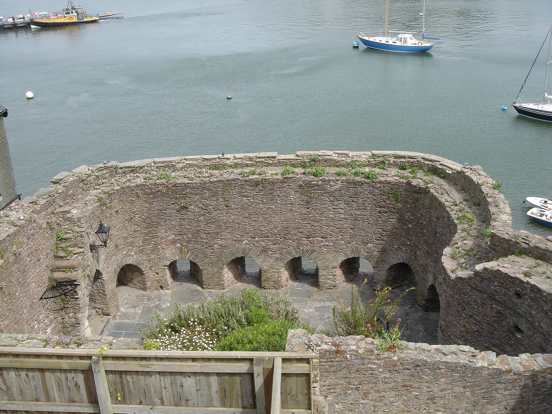
Bayard's Cove Fort
South Hams
Bayard's Cove Fort is a small, stout artillery fort on the Dartmouth waterfront in South Hams, Devon. Built in the early 16th century to guard the harbour entrance, it is one of the best-preserved reminders of the town's days as a busy port, and it is now looked after by English Heritage. What is Bayard's Cove Fort? The fort is an artillery blockhouse: a compact, low stone defence designed to hold heavy guns rather than a garrison. It also appears in older records under the names Berescove and Bearscore Castle. It is tiny by castle standards, only around ten metres across inside, yet it was built to punch above its weight. Why was it built? Dartmouth was an important harbour, and the narrow stretch of water at its entrance needed protection. The fort was raised in the early 1500s, reportedly by the townspeople themselves, to guard the quay. It formed the last line of defence. Dartmouth Castle and Kingswear Castle stood further out, and a chain could be stretched across the estuary between them. An enemy vessel that slipped past all of that would then face the guns of Bayard's Cove. How was it designed? The fort has eleven gunports for heavy artillery. They sit low in the walls so that the guns could fire at enemy ships at water level, right at the point where the harbour is at its narrowest. The design is simple and practical: thick walls, a rounded plan and a clear line of fire over the water. What happened to the fort over time? The fort was still armed during the English Civil War. In the 1640s Dartmouth was held by Royalists before Parliamentarian forces captured it in 1646. In the 18th century, as the town's fortunes declined and the old defences lost their purpose, the fort was neglected and used for storage. It was restored in the late 19th century, a period when Dartmouth was changing. The Royal Naval College opened in the town in 1863, and visitors were increasingly drawn to the waterfront. In 1940 the fort was briefly used as a machine gun post, but its restricted field of fire made it unsuitable. Visiting Bayard's Cove Fort Entry: free, with access during daylight hours. Getting there: the fort can be reached only on foot, along the cobbled quayside at the edge of Dartmouth's old town. Managed by: English Heritage, which has cared for the site since 1984. Time needed: a short stop. Most visitors spend ten to twenty minutes, often as part of a walk along the river. Frequently asked questions Is Bayard's Cove Fort free to visit? Yes. Entry is free and the fort is open during daylight hours. Can I drive up to the fort? No. It is reachable on foot only, so park in Dartmouth and walk to the waterfront. How old is the fort? It dates from the early 16th century, which makes it around five hundred years old. What was it used for? It was built to fire on enemy ships entering Dartmouth harbour. Later it served as a store, and briefly as a machine gun post in 1940. Who looks after it today? English Heritage manages the fort and keeps it open to the public.
-
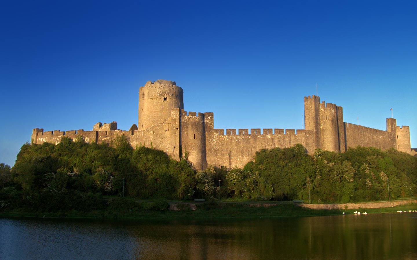
Pembroke Castle
Pembroke
Pembroke Castle is a medieval fortress in south-west Wales, standing beside the river at the heart of the town of Pembroke. Many visitors come because it is the birthplace of Henry Tudor, later King Henry VII of England, but it is just as interesting as a story of how a simple timber stronghold grew into a formidable stone castle. Why visit Pembroke Castle? The castle brings together two threads that rarely meet in one place: the early medieval Norman push into Wales and the origins of the Tudor dynasty. On site you can walk along walls, climb towers and cross open courtyards, and the higher parts of the castle give views over the town and surrounding area. It suits independent castle-hunters and families alike, since the grounds are open and easy to wander. How did the castle begin? Sources date the first structure to 1093, when the Norman lord Roger de Montgomery raised a timber fortification here. Over the following decades wood gave way to stone. In the 12th century William Marshal played a major part in strengthening the castle, and a stone tower was added in the early 13th century. Accounts differ slightly on the exact chronology, but they all describe the same journey from a small stronghold to a large defensive complex. Where was Henry VII born? Henry Tudor was born at the castle in 1457. In 1485, after winning the Battle of Bosworth, he became King Henry VII. Writers do not agree on the precise spot. Some point to a tower, others to a former guard tower now named after him. A further theory favours a winged hall-house in the outer ward, whose remains were identified through aerial photography and geophysical survey. That uncertainty adds a little intrigue to a visit. What can you do here? Visitors can explore towers, dungeons and a museum, and guided tours are available. A spiral staircase in the keep leads up to views over the town and the coast. The castle also hosts exhibitions and events within its grounds. It is one stop on the three-mile Pembroke Town Trail. Trail maps are sold at the Town Hall and the Tourist Information Centre, so it is easy to pair the castle with a walk around the whole town. Frequently asked questions Where is Pembroke Castle? In the town of Pembroke, Pembrokeshire, in south-west Wales. Does it have a royal connection? Yes. Henry Tudor, later Henry VII, was born here in 1457. When was the castle founded? According to sources, in 1093, as a timber fortification built by Roger de Montgomery. Stone defences came later. Is there an entry fee? Yes, entry is paid. Check the castle's official website for current prices and opening hours before you go. How long should I allow? Several hours is comfortable for the towers, walls and displays; allow half a day if you want to add the town trail.
-
Top Withens
Bradford
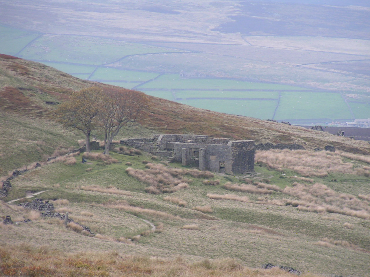
Top Withens is a ruined, roofless farmhouse on Haworth Moor in West Yorkshire, England. It stands alone in an exposed position about 420 metres (1,377 feet) above sea level. Walkers and readers come here because tradition links it with Emily Brontë's 1847 novel Wuthering Heights. What is Top Withens? Top Withens is the ruin of a former farm near the village of Haworth, in the area known as Brontë Country. Only the walls remain: the doors and windows were blocked up long ago and the roof is gone. Open moorland surrounds the site, with no trees and little shelter from the wind, which suits the bleak mood of the novel. What does the name mean? The name comes from a dialect word for willows. It is hard to imagine on a windswept, treeless hill, but that is the meaning. Is this the house from Wuthering Heights? This is the question visitors ask most. The link to the book is a tradition rather than a documented fact. A Brontë Society plaque at the ruin says the buildings bear no resemblance to the house described in the novel. Still, the remote setting fits the moorland landscape the author described around the Heights, and tradition names Top Withens as the model for the fictional farm. A short history of the farm The farm's roots reach back to the late 16th century. In 1591 a farmer named William Bentley divided his Withens estate among his three sons, Martyn, John and Luke. This created three separate farms: Lower, Middle and Top Withens. They stayed occupied until shortly after 1890. Keighley Corporation bought the decaying properties in 1903-4. In 1930 Lower and Middle Withens were demolished, while Top Withens had its doors and windows blocked to deter vandalism. That is how the roofless ruin came about. Getting there You reach Top Withens on foot. Many literary visitors start in Haworth and follow the Brontë Way through Penistone Hill Country Park and across open moorland, passing the Brontë Waterfall. The waterfall is roughly a mile from the ruin, and from there it is about another mile to Top Withens. The site also lies on the Pennine Way and the Brontë Connection walk. A popular circular route from Haworth is around 7.4 miles (about 12 km) and usually takes 3.5 to 5 hours, depending on pace and stops. Frequently asked questions Can you go inside? The building is an empty ruin with blocked openings, so it is best viewed from outside, with care on the uneven ground. Is it set up for visitors? This is remote moorland, not a developed attraction. Bring warm, windproof clothing and sturdy footwear, because the weather at 420 metres can change quickly. How long should I allow? The full circuit from Haworth takes several hours, so plan on half a day. Who is the walk for? Fans of the Brontë sisters, walkers exploring the north of England, and anyone who enjoys bare, open landscapes with a literary backdrop.
-
Conwy Railway Bridge
Conwy
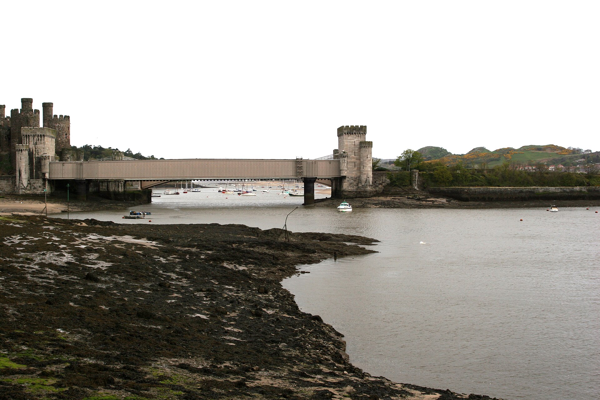
Conwy Railway Bridge is a Grade I listed wrought iron tubular bridge that carries the North Wales coast railway line across the River Conwy, linking Llandudno Junction with the walled town of Conwy. It was built in the 1840s and is the last surviving bridge of its kind by Robert Stephenson, which makes it a small piece of engineering history hiding in plain sight on the Welsh coast. What makes Conwy Railway Bridge special? Most railway bridges are open frameworks of girders or arches. This one is different: the trains run inside two long, parallel rectangular tubes made of riveted wrought iron plates. The structure crosses the estuary in a single span of roughly 400 feet, about 120 metres. Seen from the quay, it looks like a pair of severe iron boxes resting on stone abutments, a shape that feels almost industrial next to the medieval stonework nearby. The design was a bold experiment at the time. Stephenson worked on it together with the shipbuilder and engineer William Fairbairn and the mathematician Eaton Hodgkinson, who tested how iron tubes behave under load. The contractor on site was William Evans. The Conwy tubes served partly as a trial for the much larger Britannia Bridge over the Menai Strait, built on the same principle. Why is it the last of its kind? Stephenson used the tubular idea on several crossings, including a very long bridge in Canada. Over time the others were replaced or lost. The Britannia Bridge was badly damaged by fire in 1970 and was rebuilt as a two-tier truss arch bridge, so Conwy is now the only surviving example of this Stephenson design. That rarity is the main reason for its Grade I status. A later addition The bridge was not left entirely untouched. Around 1899, supporting piers were added, one on each side of the main channel, to give the long tubes extra support. The bridge is still in daily use and is owned and maintained by Network Rail. What to see nearby The bridge stands in one of the most photogenic spots in North Wales. Within a few minutes on foot you can reach the other river crossings and the historic town: the Conwy Suspension Bridge, a Thomas Telford design from the 1820s, now a pedestrian crossing; the road bridge alongside; Conwy Castle and the town walls, a short stroll from the water. Together these crossings show nearly two centuries of bridge building in one view, from a stone-towered suspension bridge to a Victorian iron tube. How to see it The best views are from the quayside in Conwy and from the riverbank on the Llandudno Junction side. The tubes look especially dramatic at low light, when the iron plates and rivets stand out against the water. If you arrive by train, you will cross the bridge yourself, though from inside the tube you will see mostly the iron walls rather than the structure itself. Frequently asked questions Who designed Conwy Railway Bridge? Robert Stephenson led the design, with significant input from William Fairbairn and Eaton Hodgkinson. William Evans built it. Can you walk across it? No. It carries an active railway line, so it can be admired only from the banks or from a passing train. Why is it so important? It is the only surviving tubular bridge of this type by Stephenson, after the Britannia Bridge was rebuilt following the 1970 fire. Where exactly is it? It crosses the River Conwy between the town of Conwy and Llandudno Junction, on the North Wales coast line.
-
Forde House
Newton Abbot
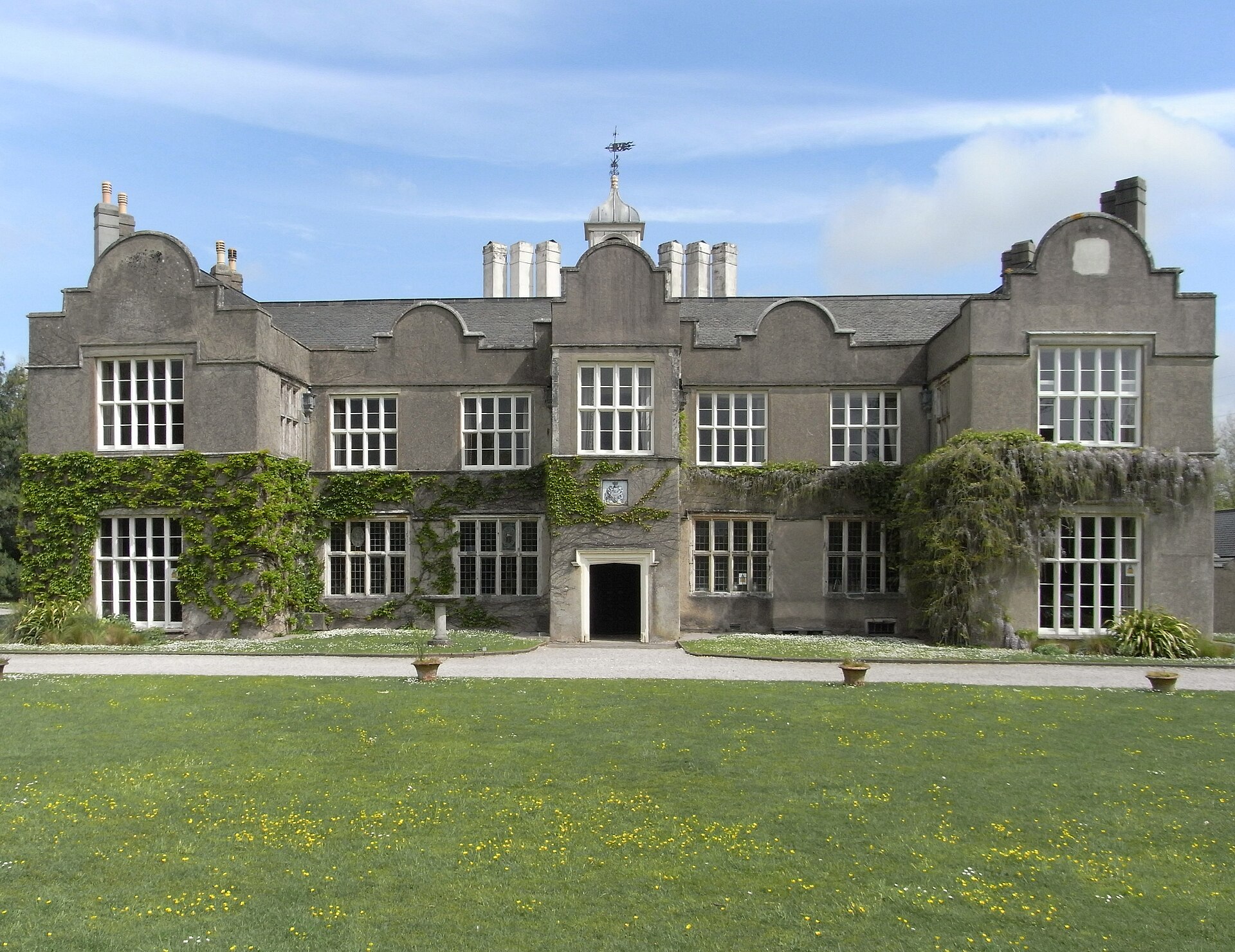
Forde House, now often called Old Forde House, is a historic manor house in Newton Abbot, Devon, in south-west England. It is a Grade I listed building, the highest level of protection, and its origins go back to around 1550. It stands as one of the finest examples of Tudor and Jacobean gentry architecture in this part of the country. What is Forde House? The house was once the manor house of the parish of Wolborough. As Newton Abbot grew, the town spread around it, and the building is now absorbed into a suburb. The south front faces Torquay Road across a front lawn, which still hints at the formal, showy character the estate was meant to have. How was the house enlarged in the early 1600s? Around 1610 the building was substantially enlarged. The expansion is associated with Sir Richard Reynell and his wife Lucy Brandon. This phase gave the house the features it is best known for today: fine 17th-century wood-carving and rich plasterwork. The interiors are regarded as some of the most accomplished examples of this craft in Devon. Who stayed at Forde House? The house has a notable guest list. Local tradition says King Charles I spent a night here in 1625 on his way to Plymouth. During the Civil War, in 1646, it sheltered Oliver Cromwell and Colonel Fairfax. In 1688 William of Orange stopped here on his journey towards the throne. These stays make it an interesting stop for anyone curious about 17th-century English history. What happened to the house in recent times? In 1978 Teignbridge District Council bought the property. It then built a modern headquarters in the grounds, which opened in 1987. The new council offices took the name Forde House, while the old mansion became known as Old Forde House so the two can be told apart. The historic house continues to be used as office and business meeting space, and it can also be hired for weddings and conferences. Can you visit Old Forde House? There are no regular opening hours for tourists. Access is mainly through special events, such as Heritage Open Days run by the local civic society, or other organised tours. Before you go, check the Teignbridge council website for current information. Even without getting inside, you can see the exterior and the setting from the grounds. Frequently asked questions Where is Forde House? In Newton Abbot, Devon, on Brunel Road close to Torquay Road. How old is the building? The oldest part dates from around 1550, with a major enlargement around 1610. What makes the interior special? Its 17th-century wood-carving and plasterwork, which contribute to its Grade I status. Is it still the council offices? The modern council offices nearby carry the name Forde House. The old mansion, Old Forde House, is used as office space and an events venue. Is entry free or open to all? There is no standard public opening, so the best chance is during an open day. Check the programme beforehand.
-

Town Hall
Berkeley
Town Hall in Berkeley is a small Georgian civic building on the corner of Market Place and Salter Street in the centre of Berkeley, a market town in Gloucestershire, England. It is a Grade II listed building that has served the town for around two hundred years, and today it works as a community events venue and a meeting place for the Town Council. What is the Town Hall in Berkeley? The building went up in the 1820s. Sources give slightly different dates: one places its construction in 1824, while the Jenner Museum says it opened in 1825. Either way, it was completed after the death of Edward Jenner, the physician best known for pioneering vaccination, who lived in Berkeley. Originally the town had an old market house on the south side of Salter Street. When that building fell into disrepair, the mayor and aldermen decided to fund a replacement and chose a site on the opposite side of the same street. The new building was designed as a market hall, with an assembly room on the upper floor that served as the Council Chamber. What does the building look like? The Historic England listing, dated October 1952, describes an early 19th-century building of ashlar stone with a rusticated ground floor and a hipped slate roof. It is nearly square in plan and has two storeys. The Salter Street front has three sash windows above three large segmental arches on the ground floor. On the Market Place side, a clock is set into the ground-floor arch, which makes it easy to spot when you walk through the centre of town. The Jenner Museum describes the hall as a Georgian building that was altered during the Victorian period. How has it been used over time? The ground floor was meant for trading, but by the middle of the 19th century the markets had stopped. The open ground floor was then used to store carts and other items. In 1905 rooms were built on the ground floor at the expense of Lord Fitzhardinge, and the Town Council still meets in one of them. Today the hall also hosts community events. Why does it matter to visitors? The Town Hall is one of the places on the Jenner trail in Berkeley. The Jenner Museum notes that Edward Jenner was appointed Mayor of Berkeley, magistrate and Justice of the Peace in 1821, so the building is linked to his civic role in the town, even though it was finished after his death. For anyone exploring Berkeley, it is a good stop to combine with the town's other historic sights, including Berkeley Castle, which is known as the place where the imprisoned King Edward II died. Frequently asked questions Where is the Town Hall in Berkeley? On the corner of Market Place and Salter Street, in the centre of Berkeley, Gloucestershire. When was it built? In the mid-1820s, around 1824 or 1825 depending on the source. Is it a listed building? Yes, it has Grade II listed status. Can I go inside? It is used for community events and Town Council meetings, so access depends on what is on. Check with Berkeley Town Council before your visit. Did Edward Jenner work here? Not in this building. It was completed after his death, but it is associated with his role as mayor of the town.
-
The Town Hall
Morpeth
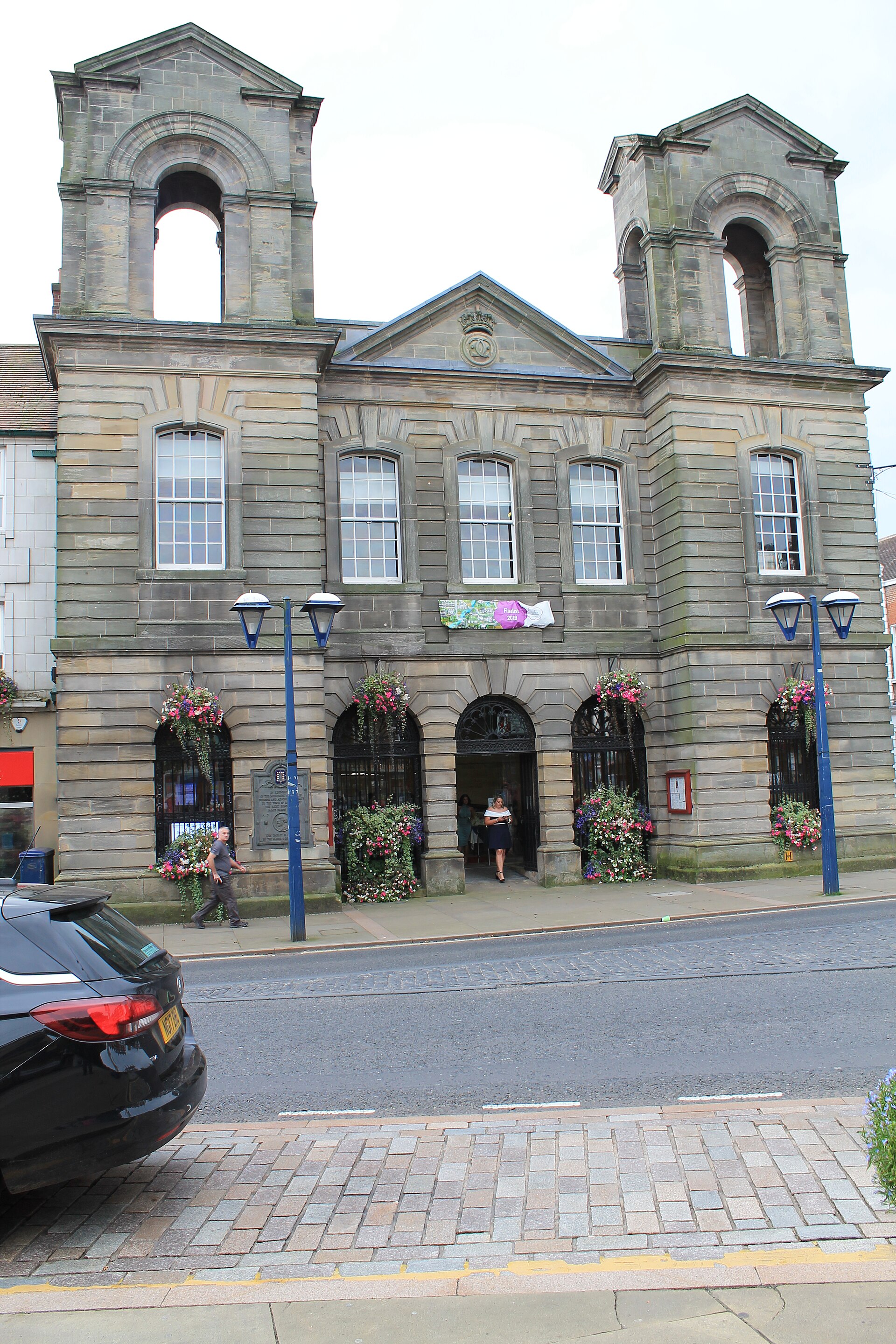
The Town Hall, Morpeth The Town Hall in Morpeth is a Baroque civic building standing in the Market Place of this Northumberland market town in north-east England. Completed in 1714 to a design by Sir John Vanbrugh, it is a Grade II listed building and one of the most recognisable landmarks in the town centre. What is the Town Hall in Morpeth? It is the historic seat of civic life in Morpeth. For generations it served as the meeting place of Morpeth Borough Council, and it still anchors the Market Place, the heart of the town. The building is faced in rusticated ashlar stone, a style of cut masonry with deeply emphasised joints that gives the walls a solid, sculptural look typical of English Baroque. Who designed it and why? The commission came from the lord of the manor, the 3rd Earl of Carlisle, who turned to John Vanbrugh, the architect and playwright associated with grand Baroque country houses. Vanbrugh's design replaced an older structure on the site. A Tollbooth, the traditional building where tolls were collected and town business was conducted, is recorded in Morpeth in 1529 and was pulled down before the new hall rose in 1714. What happened after a fire? The original building was damaged by fire in 1869. Rather than reinvent it, the town rebuilt it: the architect R. J. Johnson reconstructed the facade as a faithful facsimile of Vanbrugh's design, and the interior was also finished in an early 18th-century manner. For that reason, what you see on the Market Place today looks very much as the Georgian townspeople knew it, even though much of the fabric dates from the Victorian rebuilding. Historic England's listing describes this rebuilding with its copy of the original front. How did it become the town's property? For a long time the hall belonged to the Earls of Carlisle. In 1917 the industrialist Lord Joicey bought it from the 11th Earl of Carlisle and presented it to the town, securing its place as a public building. What treasures are connected with it? Morpeth's civic treasures include a silver mace dating from 1604, described as the oldest working civic mace in the country. Heritage events in the town have highlighted these items, which give a sense of how long Morpeth has had its own civic traditions. Tips for visitors Look at the facade first: the rusticated stonework and Baroque proportions are the main attraction, and they are best appreciated from the Market Place. Combine the visit with a walk around the town centre, where shops, cafes and other historic buildings are close together. Check local heritage listings for open days, as access to the interior depends on events and the building's current use. Frequently asked questions When was Morpeth Town Hall built? It was completed in 1714. Who designed it? John Vanbrugh, for the 3rd Earl of Carlisle. Is it a listed building? Yes, it is Grade II listed. Was it rebuilt? Yes. After the 1869 fire, R. J. Johnson rebuilt the facade to match the original design. Who gave it to the town? Lord Joicey purchased it in 1917 and presented it to Morpeth.
-
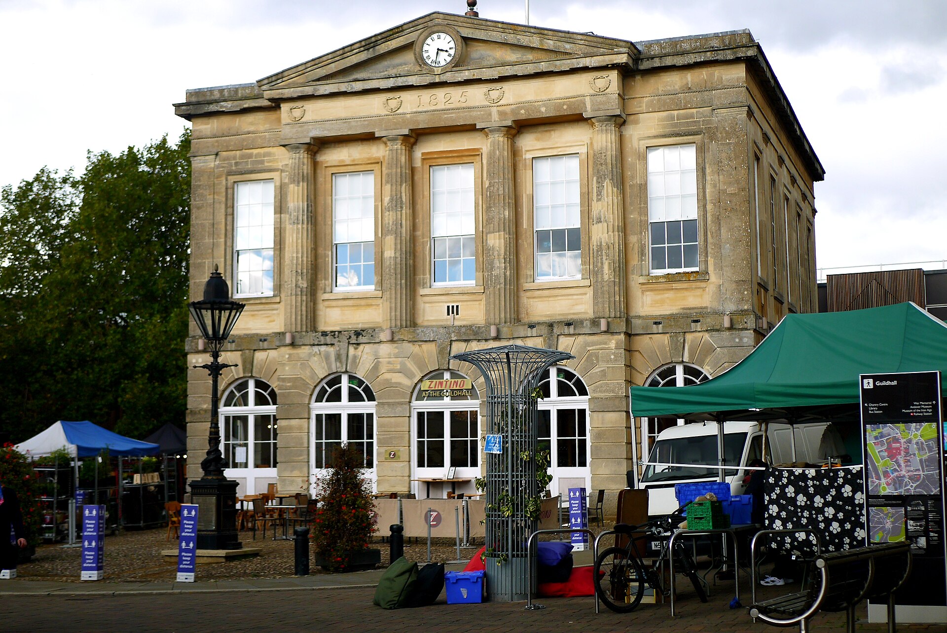
Andover Guildhall
Test Valley
Andover Guildhall is a Grade II* listed municipal building on the High Street in Andover, a market town in the Test Valley district of Hampshire, England. Completed in 1825 in the Neoclassical style, it is one of the most recognisable civic landmarks in the town centre. What is Andover Guildhall? The building was designed as the town hall of Andover and for many years served as the headquarters of Andover Borough Council. It stands right on the High Street, so you can see its stone front without leaving the main shopping street. The Grade II* listing places it among the more important historic buildings in the country, a category that covers only a small share of all listed structures. What was on the site before? The present hall is not the first on this spot. Records point to a guildhall in Andover from the early sixteenth century, with one source giving around 1513 and later remodelling in 1574, although sources disagree on the earliest dates. A new brick guildhall with a tiled roof went up in 1724. It carried a wooden cupola holding a clock and the market bell. By the early nineteenth century that building had deteriorated, and the town decided to replace it with something grander on the same site. What does the building look like? The 1825 hall was designed by architect John Harris Langdon and is built of ashlar stone. The front facing the High Street has five bays. The central section is rusticated and projects slightly from the rest of the facade. On the ground floor it has Doric columns and round-headed openings, with fanlights above the doors and windows. The upper floor has large sash windows. The overall effect is the restrained, symmetrical classicism typical of Georgian civic architecture. How is it used today? The ground floor has been used commercially, including as a restaurant, while the upper floor keeps a civic role. The hall can also be hired for events, so it remains part of local life rather than a museum piece. In 2025 the building marked its 200th anniversary. Heritage Open Day activities included a "Look Up" architecture trail along the High Street that encouraged visitors to notice the details above shop level. Practical tips for visitors The Guildhall is on the High Street in Andover town centre, so it is easy to combine with a walk through the shops and cafes nearby. Look up at the facade: the Doric columns, round-headed openings and sash windows are best appreciated from across the street. Check the Test Valley Borough Council pages for event bookings and Heritage Open Day programmes if you want to see more than the exterior. Frequently asked questions When was Andover Guildhall built? The current building was completed in 1825, replacing an earlier guildhall from 1724. Who designed it? The architect was John Harris Langdon. Is it a listed building? Yes, it is Grade II* listed. Can you go inside? Access depends on current use and events. The ground floor has hosted commercial tenants, and the hall can be booked for events, so check ahead.
-
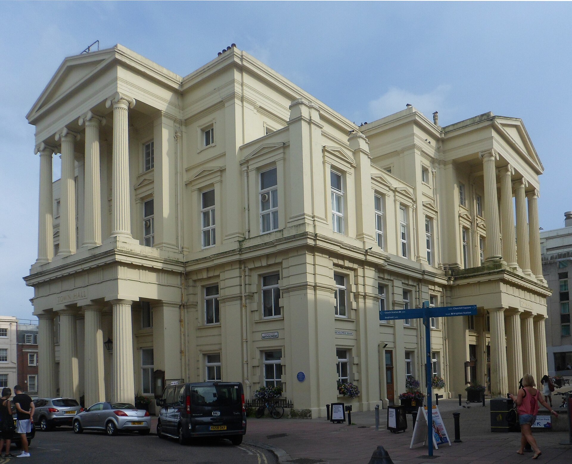
Brighton Town Hall
Brighton
Brighton Town Hall is a classical civic building in the centre of Brighton, on England's south coast, set in the Bartholomews area of the historic Old Town. Several places in the world share this name, so note that this one is in Brighton, East Sussex, and is a separate building from nearby Hove Town Hall. Why was Brighton Town Hall built? The town's earlier town hall stood in Market Street and dated from 1727. As Brighton grew rapidly during the Regency era, that building no longer met the needs of its administrators. The present building went up between 1830 and 1832. Its foundation stone was laid in April 1830 by Thomas Read Kemp, a local property developer closely tied to the town's fashionable expansion. Who designed it and what does it look like? The design was the work of Thomas Cooper, who also served as one of the town commissioners. He chose a classical, Greek-inspired style and laid the plan out as a Greek cross. The southern wing, however, was never built because the necessary land could not be bought. As a result the building is less symmetrical than first intended. Between 1897 and 1899 the hall was enlarged to cope with the demands of a growing borough. It is Grade II listed, which gives it statutory protection as a building of special interest. What else is there to see? Beneath the building are former police cells that remained in use until the 1960s. Today they house the Old Police Cells Museum, a small attraction that shows what custody was like in earlier decades. It makes a good add-on for anyone curious about local history and crime. Next to the hall lies Bartholomew Square. It was created later, and between 1984 and 1987 municipal offices, Priory House and Bartholomew House, were built around it. The area still functions as the administrative core of the city. Is it worth a visit? If you enjoy architecture and urban history, yes. The building illustrates how Brighton changed in the nineteenth century from a modest seaside town into a fashionable resort with grand public buildings. Its position in the Old Town makes it easy to combine with a walk through The Lanes, a stroll along the seafront and other central sights. Frequently asked questions Who designed Brighton Town Hall? Thomas Cooper, who was also one of the town commissioners. When was it built? Construction took place from 1830 to 1832, with an extension in 1897-1899. Why is the south wing missing? It was planned, but the land needed for it could not be purchased, so it was never erected. What is in the old police cells? The Old Police Cells Museum. The cells were used by the police until the 1960s. Is the building listed? Yes, it is Grade II listed. Is it the same as Hove Town Hall? No. Hove has its own separate town hall; Brighton Town Hall is the building in Bartholomews, central Brighton.
-

Worthing Town Hall including Assembly Hall and Worthing Room
Worthing
Worthing Town Hall, together with its Assembly Hall and the Worthing Room, is a civic and cultural complex in the centre of Worthing, a seaside town in West Sussex, England. It combines the working town hall with a theatre and concert hall, and it is one of the best-known 1930s public buildings on this part of the south coast. What is Worthing Town Hall? The building is the seat of local civic life in Worthing. It was designed in a restrained neo-Georgian style, with a symmetrical front and a central Ionic portico. Across the portico runs the Latin motto "Ex terra copiam e mari salutem", which roughly translates as plenty from the land and health from the sea, a fitting phrase for a town that grew up as a coastal resort. The complex is Grade II listed, which means its architecture is officially protected as of special interest. Who designed it and when was it built? In March 1930 the council invited architects to submit designs for a new town hall. Forty-eight entries came in, and the winner was Charles Cowles-Voysey, a London architect who also worked on town halls elsewhere in England, including Watford and Bromley. Building work began on 1 October 1931 and finished in March 1933. Prince George opened the new town hall on 22 May 1933. It replaced the earlier town hall in South Street, which no longer matched the needs of a growing borough. The listing entry also credits J. Brandon-Jones with some of the detailing. What is the Assembly Hall? Behind the main building stands the Assembly Hall, a theatre and concert hall that gives the complex its cultural side. According to the Theatres Trust database, it was given to Worthing under a covenant in 1934 by Alderman James Gurney Denton, who was mayor of the town. Other sources date its construction to 1935, so the exact completion year is stated differently depending on the source. It was also designed by Cowles-Voysey, so the hall and the town hall share one architectural idea instead of looking like separate additions. What is the Worthing Room? The Worthing Room is part of the same listed complex and appears in the official listing title alongside the Assembly Hall. It belongs to the civic part of the building and has long been used for council and ceremonial occasions. Why visit? Architecture: a good example of interwar civic design in England, easy to appreciate from the street. Location: it stands in the town centre, a short walk from the shops, and the seafront is not far away. Performances: the Assembly Hall is a venue for concerts and stage events, so a visit can be combined with an evening out. History: the building reflects the way Worthing presented itself in the 1930s, as a confident and modern seaside town. Practical tips Check the programme of the Assembly Hall before you go if you want to see the inside, since access to the halls depends on events. The portico and the front elevation can be seen at any time from outside. The town centre has several car parks, and Worthing railway station is within walking distance, so the visit is easy without a car. Frequently asked questions When was Worthing Town Hall opened? On 22 May 1933, by Prince George. Who was the architect? Charles Cowles-Voysey, who won a design competition with 48 entries. Is the building listed? Yes, it is Grade II listed, including the Assembly Hall and the Worthing Room. What does the motto on the portico mean? It is Latin for plenty from the land and health from the sea. Can I go inside? Parts of the complex, such as the Assembly Hall, are open during events. Check the current schedule before you go.
-

Runcorn Town Hall
Runcorn
Runcorn Town Hall is a historic building on Heath Road in Runcorn, Cheshire, England. Before it housed local government, it was the private mansion of a Victorian industrialist. Today it is the meeting place of Halton Borough Council and a Grade II listed building. What is Runcorn Town Hall? Despite the name, it was not built as a civic office. The building began life as a country house called Halton Grange. It passed into public hands in the twentieth century and was adapted for administrative use. Since 1974 it has been where Halton Borough Council meets, serving Runcorn and the surrounding area. What is the history of the building? The mansion was built between 1853 and 1856 for Thomas Johnson, a local industrialist and partner in John & Thomas Johnson, soap and alkali manufacturers in Runcorn. The architect was Charles Verelst, formerly known as Reed. The grounds were laid out by Edward Kemp, a noted Victorian landscape designer, according to a Cheshire Gardens Trust report. After Johnson the estate passed to the Hazlehurst family. In 1904 they leased it to Francis Boston, a tannery owner, who exercised his option to buy the house and grounds in June 1909. In the 1930s Runcorn Urban District Council bought the property and converted it into offices. Sources give different purchase dates, and one names 1932. Heritage status The building is recorded in the National Heritage List for England as Grade II listed. This gives it legal protection for its architectural and historic interest, and alterations require consent. Where is it and what should you know? The address is Heath Road, Runcorn, a town in Cheshire on the River Mersey. Its coordinates are roughly 53.3336 N, 2.7238 W. It is a working administrative building, so its main role remains council meetings and office work rather than sightseeing. For anyone interested in the industrial history of north-west England, it shows how wealth from chemical and tanning industries paid for Victorian mansions that public bodies later took over. Frequently asked questions Was Runcorn Town Hall always a town hall? No. It was built as the mansion Halton Grange for Thomas Johnson and became a council building in the twentieth century. Who designed the building and gardens? Charles Verelst designed the house and Edward Kemp laid out the grounds. Since when has the council met here? Halton Borough Council has used the building since 1974. Is it a listed building? Yes, it is Grade II listed in the National Heritage List for England. Who owned it before the council? First Thomas Johnson, then the Hazlehurst family, and later Francis Boston, a tannery owner.
-

Warrington Town Hall
Warrington
Warrington Town Hall is a historic seat of local government in the centre of Warrington, Cheshire, England. Originally a Georgian mansion called Bank Hall, it has served as the town's civic headquarters since 1870. The whole complex is recorded on the National Heritage List for England at the highest grade, Grade I. What is Warrington Town Hall? It is a group of three buildings: a main house and two detached service wings set at right angles to it, one on each side. The house and each of the wings are individually listed Grade I, a status given to only a small share of England's listed buildings and reserved for those of exceptional interest. Who designed Bank Hall? The mansion dates from 1750 and was designed by the architect James Gibbs for the merchant Thomas Patten. The architectural historian Nikolaus Pevsner called it "the finest house of its date in south Lancashire". There is a curiosity of geography here: the house stands north of the River Mersey, so it falls within the historic county of Lancashire, even though Warrington is today associated with Cheshire. How did a private house become a town hall? The borough council acquired the estate in 1870 and made it the home of local government. It still fills that role today. The Golden Gates The most recognisable feature in front of the building is an ornate cast-iron gateway known as the Golden Gates. It was made at the Coalbrookdale works for the 1862 International Exhibition in London. Tradition says it was intended for the royal Sandringham estate, but it was instead bought by Frederick Monks, a local councillor and ironmaster, who brought it to Warrington. The gates carry four winged figures of Nike, the Greek goddess of victory, and an earlier Prince of Wales motif was replaced by the town's coat of arms. They were ceremonially opened with a golden key on 28 June 1895, during Warrington's Walking Day. What to look for The Georgian facade of the house and the two flanking wings. The Golden Gates at the front of the town hall lawn. The foyer, with a mosaic floor laid in 1902 that hides initials, including QV for Queen Victoria. Frequently asked questions Where is Warrington Town Hall? In central Warrington, Cheshire, in north-west England, at roughly 53.3897 N, 2.5997 W. Is the building listed? Yes. The house and both service wings are Grade I listed on the National Heritage List for England. When was Bank Hall built? In 1750, to a design by James Gibbs, for Thomas Patten. Can visitors go inside? It is a working civic building, so access to the interiors may be limited. Check the Warrington Borough Council website before you go. Why are they called the Golden Gates? It is the popular name of the ornate gateway, which was opened with a golden key in 1895.
-
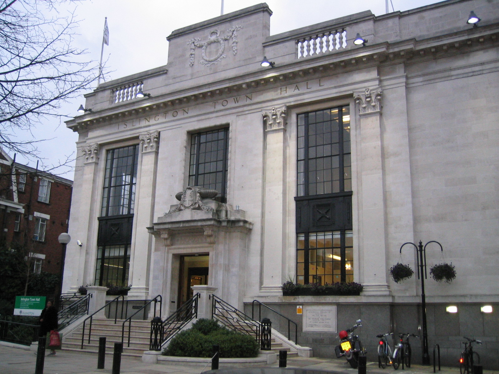
Islington Town Hall
London
Islington Town Hall is the seat of Islington London Borough Council and one of the most imposing civic buildings on Upper Street in north London. It is a Grade II listed building, and its stone front, columns and period interiors make it worth a look even if you are only passing by on the way to the area's restaurants and theatres. What is Islington Town Hall? It is a municipal building and the headquarters of the London Borough of Islington. Council business is run from here, and the building also holds a council chamber and an assembly hall. It stands on Upper Street, the main street of Islington, close to the busy centre of the district. Why was it built? The current building replaced an older vestry hall on Upper Street, dating from the middle of the 19th century. That earlier hall became the headquarters of the Metropolitan Borough of Islington in 1900, but by the 1920s it was no longer adequate. In 1920 the authorities bought a large site that had been occupied by Georgian terraced houses around Tyndale Place, and a new, much bigger town hall was planned there. Who designed it and when? The architect was Edward Charles Philip Monson. The work was carried out in stages. The rear wing facing Richmond Grove was completed in 1922. The northern part on Upper Street followed in 1925, and the assembly hall was added in 1929. The whole complex was officially opened by Mayor Alderman William Manchester on 15 March 1930. What does it look like? The Upper Street front is built of Portland stone above a polished granite base. A porch carries the borough arms, and Corinthian pilasters give the facade a formal, classical rhythm. The datestone on the porch reads MCMXXV, which is 1925. Architectural writers describe the style in different ways. The earlier section is often called restrained English Baroque, with a temple-like front marking the public entrance, while the later parts lean towards Neoclassicism. What is inside? The interiors are praised as much as the exterior. Visitors on open days have noted Art Deco touches, grand staircases and an impressive council chamber. A marble imperial stair leading up to the chamber is a particular highlight for architecture fans. Can you visit? It is a working government building, so it is not open like a museum. The best chance of seeing inside is during the annual Open House London festival, when the building has been listed among the participating sites. Check the current programme before you go. From the street you can see the front at any time. Frequently asked questions Where is Islington Town Hall? On Upper Street, Islington, in north London. Is it a listed building? Yes, it is Grade II listed. Who is the architect? Edward Charles Philip Monson. When did it open? The complex was officially opened on 15 March 1930, after construction in three phases between 1922 and 1929. Can I go inside? Access is limited because it is the council's headquarters. Open House London is the most likely opportunity. Tips for visitors Upper Street has plenty of cafes, pubs and shops, so the town hall fits easily into a walk through Islington. Look closely at the porch, the columns and the stonework on the front, and compare the more ornate older section with the plainer later one.
-
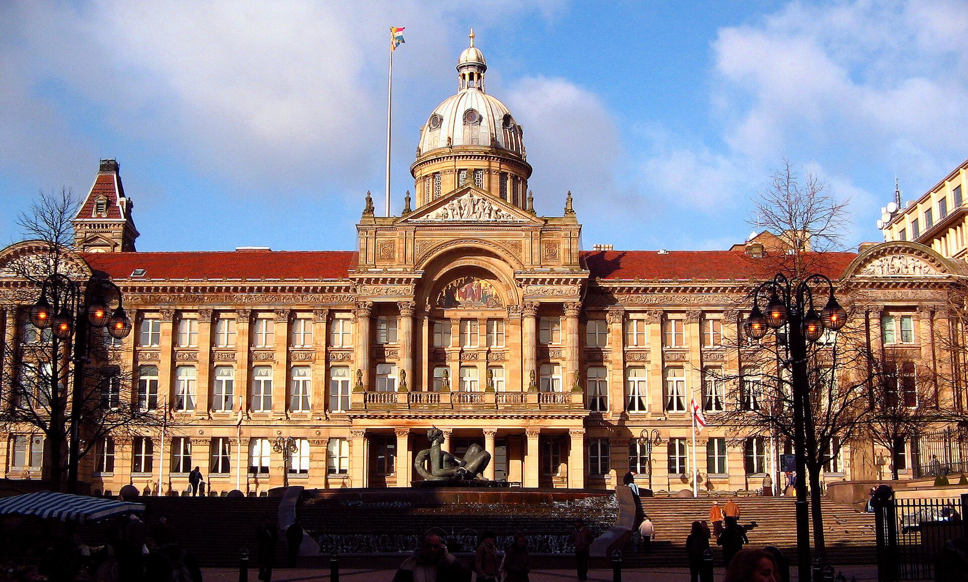
Council House, Birmingham
Birmingham
Council House in Birmingham is the seat of local government for the city and the home of Birmingham City Council. It stands in Victoria Square in the city centre, and it is one of the best-known Victorian civic buildings in the West Midlands. What is the Council House? The Council House is a working municipal building. It provides office space for employed council officers, including the chief executive, and for elected council members. Inside are the council chamber, the Lord Mayor's Suite, committee rooms and a large, ornate banqueting suite with a minstrel's gallery. The building even has its own postcode, B1 1BB. Because it is still used for running the city, it is best understood as a place where civic life happens rather than as a museum. The architecture, however, reflects the ambitions of a city that wanted its government to have a grand home. Who designed it and when was it built? The original Council House was built between 1874 and 1879 to designs by the architect H. R. Yeoville Thomason, who was born in Edinburgh in 1826 and worked in Birmingham. It is generally dated to 1879. Some sources give slightly different dates for the start of the design work, so treat the exact early years with a little caution. An extension housing the city museum and art gallery followed in 1881-85 and was also designed by Thomason. It stands beside the main building and shares the same civic character. A later, separate extension from 1911-19, the Feeney Art Galleries block, was designed by Ashley and Newman, so the complex as a whole reflects more than one period of building. Why is the building protected? The Council House is a Grade II* listed building. That is a high level of protection in England, given to particularly important buildings of more than special interest. The listing covers the Council House together with the museum and art gallery and the extension. What can you see from the outside? The most visible feature for visitors on Victoria Square is the first-floor exterior balcony. It has long been used by visiting dignitaries and by victorious sports teams to address the crowds gathered below. If you see photographs of celebrations in central Birmingham, there is a good chance the Council House balcony is in the background. Victoria Square itself is a pleasant open space in the heart of the city, which makes the Council House an easy stop when walking between the main shopping streets and other central sights. Where is it and how do you get there? The building is in Birmingham city centre, at roughly 52.48 N, 1.90 W. Most visitors arrive on foot, since the centre is compact and well served by public transport, including the nearby central railway stations and tram and bus routes. Allow a short stop to look at the facade and the square, and combine it with the neighbouring museum and art gallery. Frequently asked questions What is the Council House used for? It is the headquarters of Birmingham City Council, with offices, a council chamber, committee rooms, the Lord Mayor's Suite and a banqueting suite. Where exactly is it? In Victoria Square in the centre of Birmingham, England. Its postcode is B1 1BB. Who was the architect? H. R. Yeoville Thomason designed the original building and the first extension. Is it a listed building? Yes, it is listed Grade II*. What is the balcony for? The first-floor exterior balcony is used by visiting dignitaries and victorious sports teams to greet crowds in the square below. Can I visit the interior? It is a working government building, so access depends on events and arrangements made by the council. Check current information before planning a visit inside.
-
Statue of David Lloyd George
City of Westminster
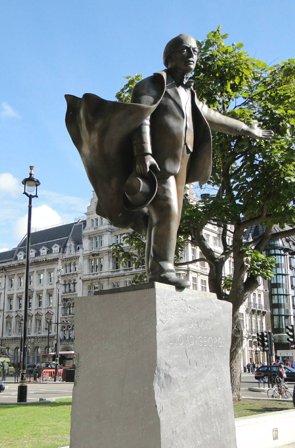
Statue of David Lloyd George is a bronze sculpture in Parliament Square, in the City of Westminster, London. It portrays David Lloyd George, the Welsh statesman who led Britain as prime minister during the final years of the First World War and the period that followed. The work is by the sculptor Glynn Williams. What can you see at the Statue of David Lloyd George? The figure stands about 2.4 metres (8 feet) tall and is cast in bronze. Lloyd George is shown in a declamatory pose, as if addressing a crowd, with a cape swirling behind him. The bronze rests on a plinth of Welsh slate, a fitting material for a man who became the most prominent Welshman in British politics. The setting matters as much as the sculpture: the statue looks out across the square opposite the Houses of Parliament, where he spent much of his career. Who was David Lloyd George? Lloyd George was a Liberal politician and one of the most influential figures in twentieth-century British public life. He served as prime minister from 1916 to 1922 and is remembered for leading the country through the later stages of the First World War. For many Welsh visitors he remains a national symbol, which explains the long campaign to see him commemorated in the capital. How did the statue come about? The monument was paid for by the David Lloyd George Statue Appeal, a charitable trust that also received support from the Prince of Wales. The idea grew from a letter by John Grigg, one of Lloyd George's biographers, who pointed out that London had no statue of him. Michael Heseltine chaired the panel that chose the artist, and Professor Glynn Williams won the commission. The Prince of Wales unveiled the statue in October 2007. Why is it a little controversial? Not everyone welcomed the monument. Commentators noted that Lloyd George had sold honours to raise money for his party, and that legacy sits uneasily beside the heroic pose. Visiting the statue is a chance to think about how a public figure can be both celebrated and criticised. Practical tips for visitors Location: Parliament Square, City of Westminster, central London. The statue stands outdoors and is free to see at any time. Nearby: The Houses of Parliament, Westminster Abbey and the other statues of statesmen around the square are all within a few minutes' walk. Best time: Early morning gives the clearest photos of the bronze with fewer crowds in the square. Getting there: Westminster Underground station is right beside the square. Frequently asked questions Who made the Statue of David Lloyd George? The sculptor is Glynn Williams, selected by a panel chaired by Michael Heseltine. When was it unveiled? In October 2007, by the Prince of Wales. How tall is it? Roughly 2.4 metres (8 feet), standing on a Welsh slate plinth. Is there an entry fee? No. It is an open-air monument in a public square. Where exactly is it? In Parliament Square, near the coordinates 51.5008, -0.1267, opposite the Palace of Westminster.
-

Tirah Memorial
Oksford
Tirah Memorial is a stone obelisk in Bonn Square in the centre of Oxford, honouring men of the 2nd Battalion Oxfordshire Light Infantry who died in 1897–98 during the Tirah Expedition and the Punjab Frontier Campaign. It is a modest monument that many visitors walk past, yet its story is surprisingly rich. What does the memorial commemorate? The monument remembers British soldiers who served on the North West Frontier of British India, where the campaign aimed to suppress rebellious tribes. Depending on the source, 61 or 62 names are carved on it. Strikingly, few of these men fell in battle: of the 62 named, 53 died of disease, which in the harsh conditions of the campaign claimed far more lives than enemy fire. Who built it, and when? Local dignitaries unveiled the memorial on 6 July 1900. It was designed by Francis Inigo Thomas, better known as a garden designer and artist, and built by Franklin of Deddington. The obelisk stands about 25 feet (roughly 7.6 m) tall, cut from stone from Monk's Park Quarry near Bath and set on a base of Doulting stone. It was listed in 1972, and several sources call it Oxford's first free-standing war memorial. Why is the square called Bonn Square? The square was once the churchyard of St Peter-le-Bailey. While digging the foundations for the memorial, workmen came across human remains, which were reburied at Osney Cemetery. The square took its current name in 1974, after Bonn, the German city twinned with Oxford. An imperial-era obelisk therefore stands in a place whose name now symbolises post-war reconciliation. What is its condition today? The memorial is often described as forgotten. A local historian, in a recent book, compared it with the city's better-kept war memorials and called it ignored and falling into disrepair. It is still worth a pause: it prompts questions about how a city remembers, or overlooks, episodes from its imperial past. Frequently asked questions Where is the Tirah Memorial? In Bonn Square in central Oxford, England, close to the main shopping streets. Is there an entrance fee? No. It stands in an open public square and can be seen at any time. Who does it commemorate? Soldiers of the 2nd Battalion Oxfordshire Light Infantry who died in 1897–98 on the Tirah Expedition and Punjab Frontier Campaign. How long does a visit take? A few minutes is usually enough, though it is worth reading the names on the obelisk and looking around the square. Is it a protected monument? Yes, it has been on the National Heritage List for England since 1972. Who is it for? Military history enthusiasts, walkers exploring the less obvious corners of Oxford, and anyone curious about how British towns commemorate colonial-era campaigns. It combines easily with a stroll to other sights in the city centre.
-

Meanwood War Memorial
Leeds
Meanwood War Memorial in Leeds is a Grade II listed memorial on Green Road in the Meanwood district, north of the city centre. Instead of the usual obelisk or soldier statue, it takes the form of a small timber shelter sheltering a bronze crucifix, which makes it one of the more distinctive memorials in West Yorkshire. What is this memorial and who designed it? The memorial dates from around 1920 and was built to honour local people killed in the First World War. It was designed by A. R. Powys and commissioned by Walter Rowley. Historic England's listing notes that Rowley's nephew died at Villers-Bretonneux in France, a personal link behind the commission. Names from the Second World War were added later. What will you see? A base of hammer-dressed gritstone. A timber shelter with a stone-slate roof. A bronze crucifix under the canopy; the plastered ceiling is painted with gold stars, and the halo carries blue enamel. First World War lettering and the roll of names on the back wall of the shelter. A bronze plaque on the stone base naming 46 people who died in 1939-45. A low wall with a dedication plaque in front. When was it unveiled? Both the IWM War Memorials Register and War Memorials Online give 12 August 1922 as the date of unveiling and dedication, with the Lord Lieutenant of the West Riding of Yorkshire attending. The Leeds War Memorials website also mentions a rededication in 2009, although details of that event could not be confirmed. Where is it and how do you get there? The memorial stands beside Holy Trinity Church on Green Road, at the junction with Memorial Drive (about 53.8298 N, 1.5682 W). The National Heritage List for England entry, number 1256215, names it "War Memorial at South End of Memorial Drive". It was listed on 11 September 1996. From central Leeds it is a short drive; check a West Yorkshire journey planner for current bus options. It stands in a public space, so there are no tickets or opening hours. When should you visit? It can be seen year-round. It is most moving around 11 November and Remembrance Sunday, when wreaths and poppies are laid by the local community. In bright daylight the gold stars and enamel detail are easiest to make out. Frequently asked questions Is there an admission fee? No. The memorial is outdoors and free to visit. How long does a visit take? Ten to fifteen minutes is enough, longer if you want to read the names and inscriptions. Is the memorial protected? Yes. It is a Grade II listed structure, listed in September 1996. Who does it commemorate? Local people lost in the First World War, plus 46 people who died in 1939-45, whose names were added afterwards.
-
Memorial to Queen Victoria
Leeds
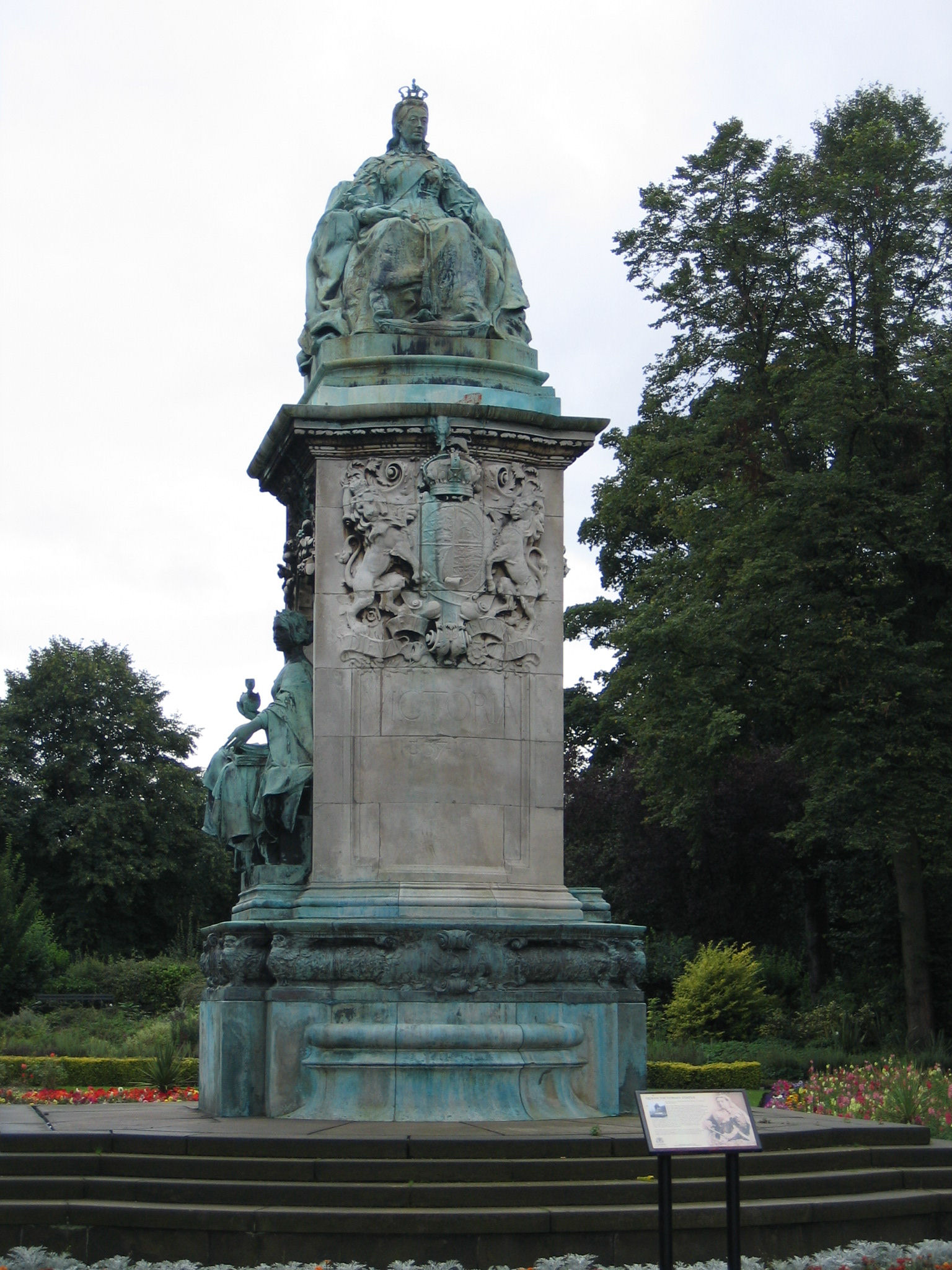
The Memorial to Queen Victoria in Leeds stands on Woodhouse Moor, a large public park northwest of the city centre. It was created by sculptor George Frampton working with architect Leonard Stokes, and it is a Grade II* listed monument, the second-highest level of protection in England. What will you see? Victoria is shown enthroned in her coronation robes. The figure and the frieze are cast in bronze, while the base is Portland stone. Niches on the sides of the plinth hold seated figures of Peace on the left and Industry on the right. An inscription on the back records that the people of Leeds paid for the monument through public subscription. Walk all the way around it, since the sculptural detail runs along every side of the plinth. What is its history? The listing dates the work to 1903, and the monument was unveiled on 27 November 1905. It first stood in Victoria Square in front of Leeds Town Hall. In 1937 it was moved to Woodhouse Moor after the space outside the Town Hall was reorganised. Despite sitting outside the centre today, it is often counted among the finest monuments in the city. How do you get there? The memorial is in Woodhouse Moor park in the Hyde Park and Woodhouse area, at roughly 53.811 N, 1.558 W. From the city centre you can walk or take a local bus towards the university. The park borders the University of Leeds campus, so services on this route are frequent. When should you visit, and what does it cost? The monument stands in an open park, so there is no ticket and no opening time. Choose a day with good light, when the bronze contrasts well with the pale stone. Looking at the memorial takes 10 to 15 minutes, and a stroll around Woodhouse Moor makes it about an hour. The ground is flat with paved paths. What else is nearby? Woodhouse Moor holds other statues relocated from central Leeds, including one of Robert Peel, which is also listed. The park is a popular spot for walks, jogging and meeting friends, so it pairs well with a break between city sights. Frequently asked questions Is there an entrance fee? No. The memorial is in a public park and can be visited free at any time. Who made the memorial? Sculptor George Frampton, with architect Leonard Stokes. Why is it on Woodhouse Moor and not by the Town Hall? It was unveiled outside the Town Hall in 1905 and moved to the park in 1937 when the area around the Town Hall was redeveloped. How long should I plan for? About 10 to 15 minutes at the monument, or an hour with a short walk through the park.
-
Ide War Memorial
Teignbridge
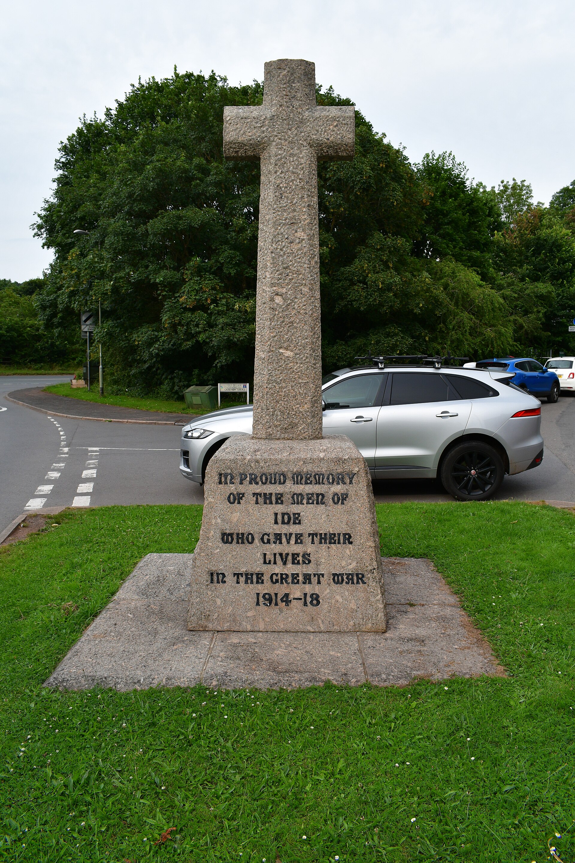
Ide War Memorial stands on Fore Street in the village of Ide, just south-west of Exeter in Devon's Teignbridge district. This granite cross has been a Grade II listed structure on the National Heritage List for England since 2015. What is the memorial? Put up around 1920, it honours the people of Ide who died in the First World War. Names and inscriptions for the Second World War were added later. Historic England designated it on 4 February 2015 for its special architectural and historic interest. What does it look like? The monument is built of roughly dressed granite, square in plan and set on a base of four paving slabs. A tapering shaft with chamfered corners rises to a Latin cross, with the chamfers running up into the cross arms. It is a modest village memorial with no figurative sculpture, which is typical of the period. What can you read on it? The west face carries a dedication to the men of Ide who died in 1914–18. The opposite face lists the names from the First World War. The north face lists those who died in 1939–45. How do you get there? Ide is roughly 3 km south-west of Exeter city centre. The memorial is on Fore Street, postcode EX2 9RQ, about 2 km from Exeter St Thomas station, so you can walk it or take a local bus from the city. Coordinates: 50.705 N, 3.557 W. How long does a visit take? It is an open-air site with free access. Allow 15 to 30 minutes to read the inscriptions and take in the cross. It fits well into a walk around the village or a half-day out from Exeter. When is the best time to visit? Any time of year in daylight, when the lettering is easy to read. Around 11 November, when Remembrance Day is marked across the UK, wreaths and poppies are laid at memorials like this one, which gives the visit extra meaning. Frequently asked questions Is there an entrance fee? No. The memorial stands outdoors and can be visited free of charge. Is it a listed monument? Yes. It is Grade II listed, List Entry 1423553 on the National Heritage List for England. Who does it commemorate? Residents of Ide who died in the two world wars. The 1914–18 and 1939–45 names appear on separate faces. Can I bring a dog? Yes. It is a public, open site, and nothing restricts visiting with a dog.
-
Norman Cross
Huntingdonshire
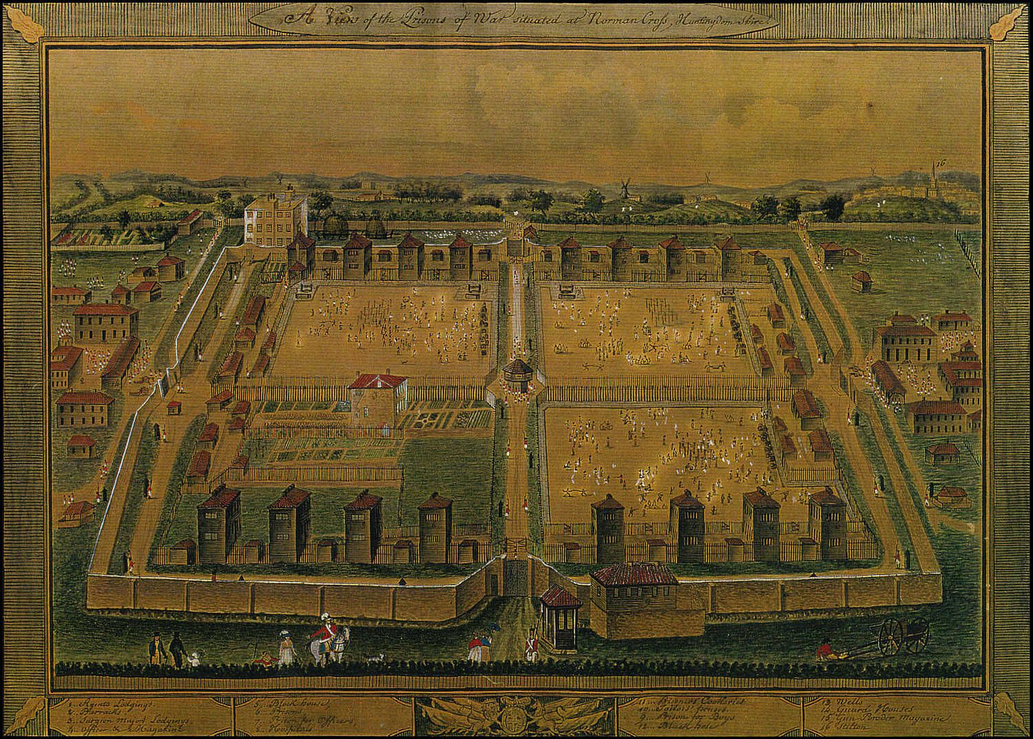
Norman Cross is a roadside war memorial in the old county of Huntingdonshire, now part of Cambridgeshire, a few miles southwest of Peterborough. A limestone column topped with a bronze eagle honours the prisoners who died at a nearby Napoleonic-era depot. The column is Grade II listed by Historic England, and the site of the depot itself is a scheduled monument. What was the Norman Cross depot? Built in the mid-1790s beside the Great North Road, the depot was a purpose-designed camp for prisoners of war and stayed in use until 1814. More than 30,000 men passed through over its lifetime, mostly French, along with Dutch and German prisoners, and as many as 7,000 were held at once. Deaths are usually put at around 1,700 to 1,770, mainly from disease. It is often described as one of the first camps of its kind. What can you see there? The memorial is a limestone column crowned by a bronze eagle. Bronze plaques at its foot commemorate prisoners who died between 1797 and 1814, and an information panel explains the depot's story. The Entente Cordiale Society, which promoted Anglo-French friendship, unveiled it in 1914. Vandals stole the eagle in 1990. The column was rebuilt and rededicated on 31 October 1998, and a new eagle by sculptor John Doubleday was inaugurated on 2 April 2005. This is a small roadside monument with no visitor centre, so expect a short stop. Items made by the prisoners, including carved bone models, are kept at Peterborough Museum. How do you get to Norman Cross? The memorial stands beside the southbound side of the A1(M), by the junction with the A15 towards Yaxley and Peterborough. Driving is the easiest option, roughly ten minutes from Peterborough. The spot lies on a busy road, so check the map for a safe place to park before you set off. When should you visit? You can see it all year, free of charge. Pick a dry day, as everything is outdoors. It pairs well with a day in Peterborough, taking in the cathedral and the museum. Frequently asked questions Is entry free? Yes. The memorial is beside the road and open to view with no ticket. Does any of the camp survive? No. The barracks are gone, and the depot's site is protected as an archaeological monument. The column and plaques are what remains to see. How long does a visit take? About 15 to 20 minutes is enough to look at the column and read the plaques. Why is the eagle modern? The original was stolen in 1990. The current bird is by John Doubleday and dates from 2005.
-
Wagoners' Memorial
Sledmere
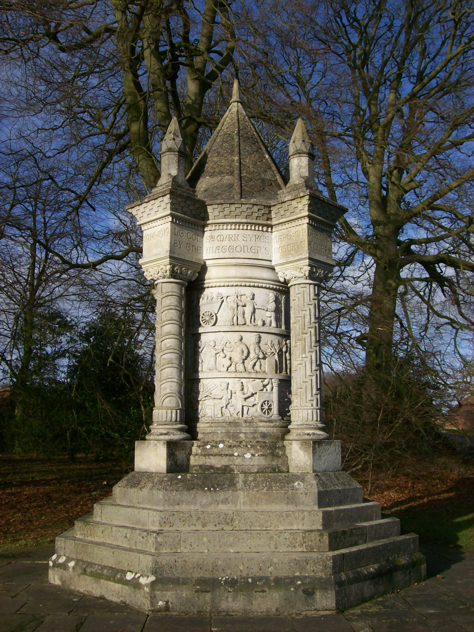
Wagoners' Memorial in Sledmere is a war memorial in the middle of a village in the East Riding of Yorkshire, northern England. A squat stone column carved all the way round, it honours the men of the Waggoners Special Reserve, a unit of horse-wagon drivers raised on the Yorkshire Wolds. It is one of Britain's most unusual First World War monuments and, since 2016, it has held the top Grade I heritage listing. Who built the Wagoners' Memorial, and why? Sir Mark Sykes, 6th Baronet, who owned the Sledmere estate, designed it. In 1912 he organised a corps of drivers from farm workers and tenant farmers across the Wolds to handle the horse-drawn wagons that kept supplies moving. Sykes died in February 1919 while attending the Paris Peace Conference, so he never saw the finished work. The memorial went up in 1919–20 and was unveiled on 5 September 1920. The sculptor was Carlo Magnoni. What will you see? The monument is low and heavy, with a carved band spiralling up the shaft. That spiral is why people often compare it with Trajan's Column in Rome. The subject is very different, though. Instead of imperial victories, the reliefs show ordinary countrymen: Sykes recruiting them, the call-up, the journey to France, life with the wagons and scenes from the battlefield. Nikolaus Pevsner called it "curiously homely", which suits it well. Walk around the column slowly and read the frieze section by section. A few steps away stands the Eleanor Cross, a village cross from the 1890s modelled on the one at Hardingstone, which Sykes turned into a memorial for men from his estate. Both were raised to Grade I during Historic England's First World War centenary programme, and two memorials of that rank in a single village was described as unprecedented. How do you get there, and how long do you need? Sledmere lies on the B1252 across the Yorkshire Wolds, between Driffield and Malton. The memorial stands on the main street, close to St Mary's Church and the grounds of Sledmere House. Most visitors arrive by car, and there is space to stop nearby. The memorial is in public space, free to see at any time. Twenty to thirty minutes covers the column and the cross; add Sledmere House and the church and you have a half-day outing. When is the best time to visit? Go when the light is good. Side sun in the morning or late afternoon makes the carvings easier to read. Spring and summer pair well with walks on the Wolds. Check the Sledmere House website for opening times if you plan to go inside. Frequently asked questions Is there an entrance fee? No. The memorial stands in the village and can be viewed at any time. Whom does it commemorate? Drivers of the Waggoners Special Reserve, recruited from Wolds farms. Sources give different totals, from roughly a thousand to 1,127 men. Why is it compared to Trajan's Column? Because of the spiral frieze wound around the shaft. Here the heroes are farm wagoners, not an emperor. What else is nearby? The Eleanor Cross, St Mary's Church and Sledmere House with its parkland.
-
Royal Air Force Memorial
City of Westminster
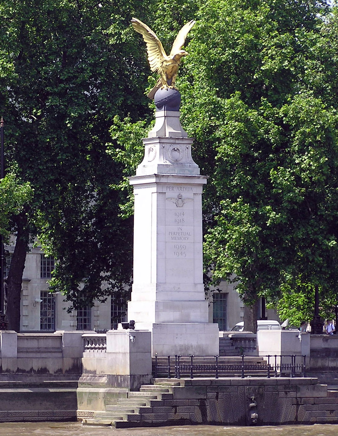
The Royal Air Force Memorial stands on the Victoria Embankment in the City of Westminster, central London. It honours airmen lost in the First World War and, by extension, in later conflicts, and it is regarded as the official memorial of the RAF and its associated services. What will you see? A slender Portland stone pylon carries a gilded bronze eagle with outstretched wings. The bird perches on a darker, patinated bronze globe, circled by a gilded band marked with the signs of the zodiac. It faces the Thames and, beyond it, the Channel and France, where so many First World War airmen served. The memorial was designed by architect Reginald Blomfield; the eagle was sculpted by William Reid Dick. It was unveiled in July 1923 with the Prince of Wales in attendance. Why does it matter? The structure was listed at Grade II in 1958. In 2018, the RAF's centenary year, Historic England raised it to Grade II*, citing its historic significance as a witness to 20th-century air force sacrifice and its artistic merit, the bronze eagle included. It remains a focus for anniversary and remembrance ceremonies. How do you get there? The memorial is at Whitehall Stairs, between Westminster Bridge and Charing Cross Bridge, just east of the Ministry of Defence building. From Embankment or Westminster tube stations it is a few minutes' walk along the river. Cleopatra's Needle is nearby, so the two fit neatly into one stroll. When should you visit? It sits on an open riverside promenade and is accessible free at any hour. Daylight is best for photographs, when the gilding catches the sun. Around Remembrance Sunday in November, or the RAF's anniversary, you may catch ceremonies here. What else is nearby? Several other military memorials line the Embankment, and Whitehall, the Houses of Parliament with Big Ben, and Victoria Embankment Gardens are all a short walk away. Don't confuse this site with the RAF Bomber Command Memorial in Green Park or the RAF Museum; both are separate places. Frequently asked questions Is there an entry fee? No. The memorial is in a public space and can be viewed free at any time. Who designed it? Reginald Blomfield was the architect and William Reid Dick sculpted the gilded eagle. When was it unveiled? In July 1923, with the Prince of Wales present. How long does a visit take? Ten to fifteen minutes for the memorial itself. Pair it with a walk along the river and Whitehall.
Earn badges for the places you visit
Download NextOnTrip, discover new places and check off your trails.