Monuments in the United Kingdom
A guide to 579 Monuments in the United Kingdom — with descriptions, photos and traveler visits from the NextOnTrip community. Locations spread across 331 cities and towns. Most visited by the community: Chiswick House, Backwell House, Westbury On Trym War Memorial.
-
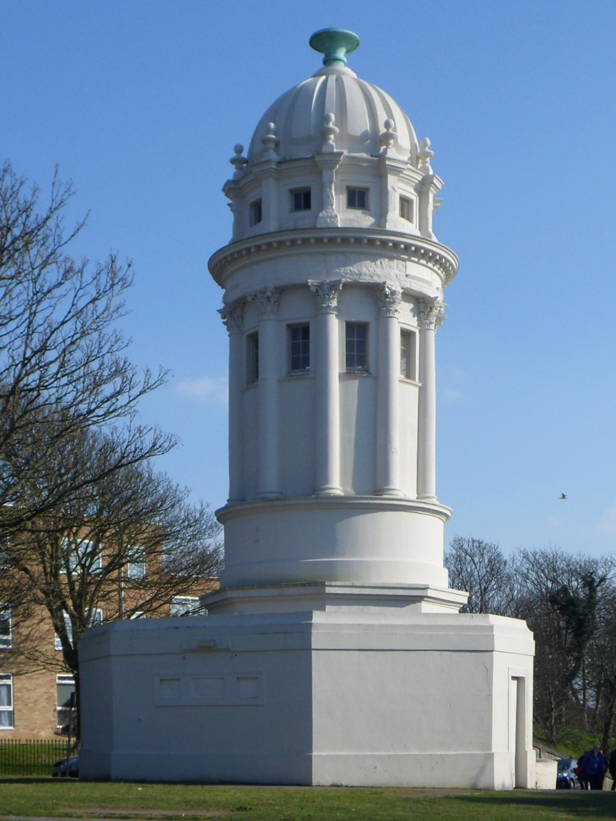
Pepper Pot
Brighton
The Pepper Pot in Brighton is a Grade II listed garden tower dating from 1830, standing in Queen's Park on the eastern side of the city (East Sussex, England). It belongs to Brighton and Hove City Council and can be admired from outside only. What is the Pepper Pot? The nickname comes from the slim shape, which recalls a pepper shaker. The base of the tower is octagonal, while the upper stages are round. It was designed by Charles Barry, the architect later known for the Houses of Parliament, for Thomas Attree, a Brighton solicitor and property developer who owned the land. The tower originally stood in the grounds of Attree's grand villa. The house was pulled down, and the Pepper Pot remained as one of the few traces of the estate. Historic England listed it on 13 October 1952. What was it built for? Nobody agrees on its first purpose. One account says it held a tank and pump supplying water to the villa, and the tower does sit over an old well. An architectural journal from 1834 describes a steam engine and an observatory instead. Over the years the building took on many roles. It was a printing works where the Brighton Daily Mail was produced, a lookout post during the Second World War, a scout headquarters, an artist's studio and a public toilet. Today it is sealed and unused. The council carried out restoration work in 2011. How do you get there? The tower is inside Queen's Park, in the neighbourhood of the same name just east of central Brighton, at roughly 50.8273 N, 0.1248 W. The park is open to walkers and has no entry charge. What will you see? You cannot go inside, so the visit is about the exterior: the octagonal base turning into a circular upper tower, and the survival of a garden folly whose villa has vanished. A lamp post beside the tower has its own listing as well. Combine the stop with a stroll through the park. When should you visit? The tower is visible from outside at any time, but daylight gives the best view and photos. Frequently asked questions Can I go inside the Pepper Pot? No. The tower is closed and not in use, so you see it from the outside. Who designed it? Charles Barry, in 1830, for Thomas Attree. Is the Pepper Pot a listed building? Yes, it has been Grade II listed since 13 October 1952. Is there an admission fee for Queen's Park? No, it is a public city park.
-
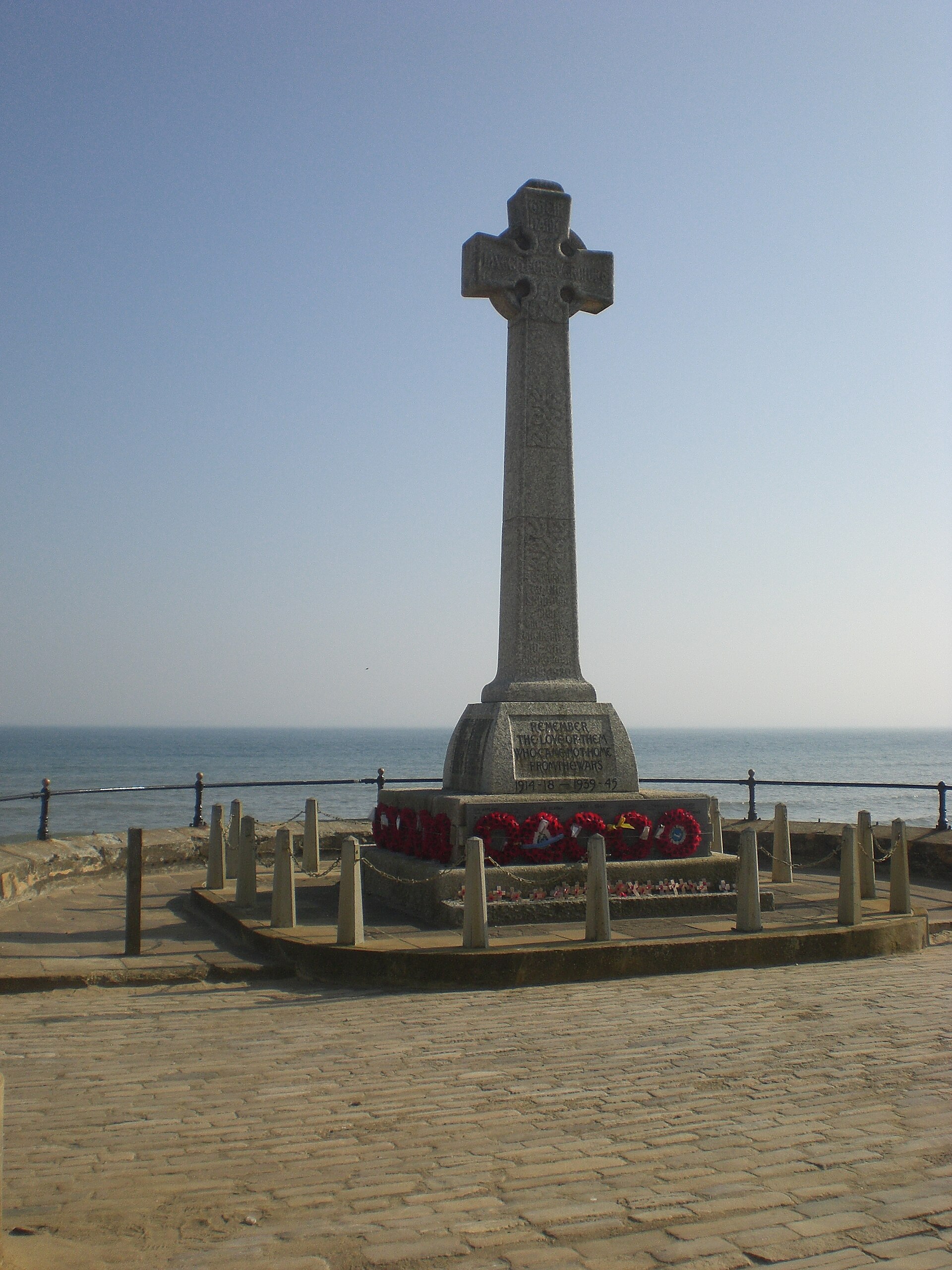
Sandown War Memorial
Sandown
Sandown War Memorial stands on the seafront Esplanade in Sandown, on the east coast of the Isle of Wight, England. This Celtic cross, unveiled in 1921, honours local people killed in the wars of the 20th century, and it has been Grade II listed on the National Heritage List for England since 2019. Who designed it, and what is it made of? Percy Stone, a local architect and antiquarian, designed the memorial. It takes the form of a Celtic cross with carved decoration on its western face, and it cost roughly £560 to build. The base has a story of its own: its stones were once gun mountings at Yaverland Battery, part of the Victorian coastal defences near Sandown. The memorial to the dead therefore rests on stonework that once served the military. When was it unveiled, and who does it commemorate? Princess Beatrice, then Governor of the Isle of Wight, unveiled the memorial on 25 July 1921. It names 78 Sandown men who died in the First World War. A plaque for the Second World War was added in 2004, so the monument now covers both conflicts. Why is it listed? Historic England describes the memorial as an eloquent witness to the impact of global events on a small community, and to the sacrifice that community made. That local significance is the reason behind the Grade II status, granted in April 2019. When is the best time to visit? The memorial is open to view all year, with no ticket or opening hours. The most meaningful time is Remembrance Sunday in November, when the town holds its commemoration here and poppy wreaths are laid at the foot of the cross. In summer the Esplanade is busiest, so early morning is quieter. How do you get there? The memorial is on the Esplanade, a few minutes' walk from the beach and the town centre. Sandown has bus connections across the island and a station on the Island Line railway, and ferries from Portsmouth and Southampton bring visitors to the Isle of Wight. A visit takes ten to fifteen minutes and fits easily into a seafront stroll. Frequently asked questions Is Sandown War Memorial a listed monument? Yes. Historic England listed it at Grade II in April 2019. Who designed it? Percy Stone, a local architect and antiquarian. Who does it commemorate? Seventy-eight local men lost in the First World War, plus the casualties of the Second World War, recorded on a plaque added in 2004. Do I need a ticket? No. It stands in a public space on the Esplanade and can be visited at any time.
-
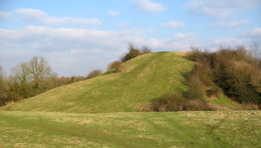
Brinklow Castle
Rugby
Brinklow Castle in Brinklow, near Rugby in Warwickshire, is a Norman motte-and-bailey earthwork that locals call "the Tump". Don't expect stone walls or towers. The castle was built of timber, and only its mound and banks remain. It suits history fans and anyone who likes a short country walk. What is Brinklow Castle? The site sits in the village of Brinklow, between Coventry and Rugby, right beside the line of the Roman Fosse Way. It lies roughly midway between Warwick and Leicester. Some sources date it to about 1069, during William the Conqueror's campaigns in the north. Others say Aubrey de Coucy reworked it in the late 11th century. The castle was never rebuilt in stone. It served for a fairly short time and was abandoned in the 13th century. Today it is a scheduled monument (Historic England list entry 1011368). What can you see? The star feature is the tall, steep motte. Sources give its height as 12 to 15 metres, with a flat top about 15 metres across. Around it you can trace two enclosures, each protected by a bank and ditch: a smaller inner court and a larger outer one. The summit gives views over the village and surrounding countryside. Access: there are no formal paths and no ticket is needed, as the site is public open space. You cross rough grassland that can turn muddy after rain, so wear sturdy footwear. The climb up the mound can be hard for visitors with limited mobility. How do you get there? A small car park on Ell Lane has an information panel and a gate that leads straight to the motte. Buses between Rugby and Coventry stop on Broad Street in Brinklow, and footpaths lead on from there. When should you visit? The site is open all year and free. Dry weather in spring, summer or early autumn is best, when the grass is firm. Allow 30 to 45 minutes. You can combine it with a stroll through the village and a look at the neighbouring church of St John the Baptist. Frequently asked questions Is there an entry fee? No. The site is public and free to visit year-round. Are any castle walls left? No. It was a timber-and-earth castle. The mound and earthworks are what survive. Can I use a metal detector? No. The monument is protected, and metal detecting and unauthorised digging are not allowed. Is there parking? Yes, a small area on Ell Lane next to the information panel and the gate to the mound.
-
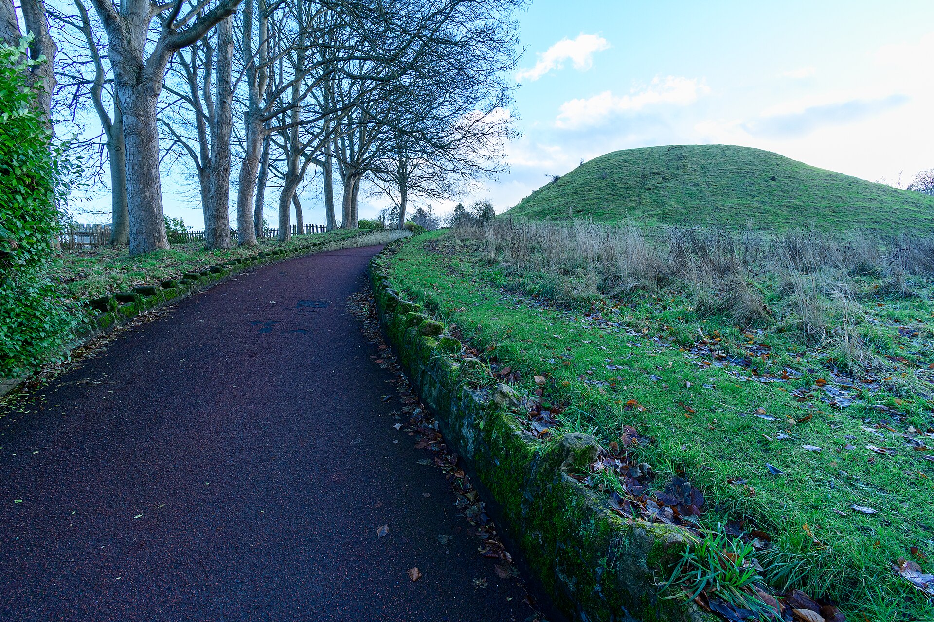
Motte and bailey castle on Haw Hill
Morpeth
Motte and bailey castle on Haw Hill in Morpeth, Northumberland, is a grassy mound in Carlisle Park that carried the town's first castle. Locals call it Ha' Hill. No walls remain, only earthworks and a ditch, but the hill is a scheduled monument and makes an easy, quiet stop on a walk through the park. What is Haw Hill? It is a medieval earthwork castle of the motte-and-bailey type: an artificial mound (the motte) topped by a fortified timber tower, with an adjoining enclosure (the bailey) for everyday use. Historic England records that the mound was shaped by scarping the north-eastern tip of a narrow ridge. It is roughly oval, with steep sides to the north, east and west, while a ditch up to 3.5 m deep cuts it off from the bailey on the south. The site was added to the heritage list (entry 1017376) in 2000. What is its history? Local sources link the first fortress at Morpeth with the de Merlay family and the year 1095, when the castle was seized, according to accounts, by King William II. It is mentioned again in 1138. According to the Keys to the Past record, a stone castle on a stronger site to the south replaced it in the 12th century. That successor survives today as Morpeth Castle on the neighbouring hill, a separate monument that should not be confused with this one. Sources disagree on whether King John's attack in 1216 hit Haw Hill or the later castle. What has been found here? The hill has seen little investigation. In 1830 William Woodman dug at the summit and recovered carved stones, including scalloped capitals and wedge-shaped arch stones. He also uncovered the foundations of a long, narrow building. A topographic survey and historical research took place in 1999, before landscaping work in the park, and a later survey picked out an artificial platform on top of the mound. How do you visit? Haw Hill lies inside Carlisle Park, beside the River Wansbeck in the centre of Morpeth. You can walk up to it freely, with no ticket and no guide. There are no rebuilt walls or displays, so expect to see the shape of the mound, its slopes and the line of the ditch, plus a view back over the park. It pairs well with a stroll around Carlisle Park and a look at Morpeth Castle on the next hill. Allow 15 to 30 minutes for the mound itself. Frequently asked questions Do I need to pay to visit? No. The hill stands in a public park and you can look at it and climb it free of charge. Are any castle walls still standing? No. Only the earthworks survive: the mound, its slopes and the ditch. The timber buildings are gone, and the finds from the 19th century are a handful of carved stones. Is Haw Hill the same as Morpeth Castle? No. Haw Hill marks the site of the first castle. Morpeth Castle, its successor, stands on the adjacent hill and is a separate monument. Why is it also called Ha' Hill? It is a local, shortened form of Haw Hill that appears in historical accounts and heritage records.
-
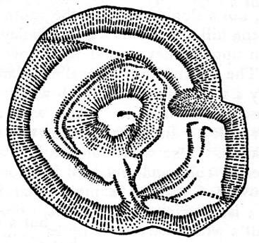
Montacute Castle
Montacute
Montacute Castle in Montacute, Somerset, is not a walled fortress you can wander through. It is the earthwork remains of a Norman motte-and-bailey stronghold, shaped out of St Michael's Hill. The banks and terraces survive, and an 18th-century folly tower on the summit gives views across three counties. What was the castle at Montacute? The castle was most likely raised around 1068 by Robert, Count of Mortain, half-brother of William the Conqueror. The hilltop was shaped into a steep mound (the motte), with a defended enclosure (the bailey) on the south-eastern slope and an outer terrace running round the hill. A chapel dedicated to St Michael stood here and was still in use in 1315. By 1540 the antiquary John Leland recorded the castle as a ruin, and stone was gradually carted away until the buildings vanished. The site is a scheduled monument (Historic England list entry 1008466), protected since 1933. The tower on top is excluded from the scheduling. What can you see on the hill? The main landmark is the folly tower, around 15 metres tall, built in 1760 by Edward Phelips V of nearby Montacute House. A spiral staircase leads up inside, and from the top you can look over Somerset, Dorset and Wiltshire. The tower is cared for by the National Trust. The rest of the interest lies in the ground itself: the steep cone, the terrace lines and slopes show how medieval builders used a natural hill as a ready-made defence. How do you get there? Start at the Castle Hill car park in Montacute. A short but fairly steep path climbs to the summit. The hill sits right beside the village, a few minutes from the centre. Montacute House, the Renaissance mansion run by the National Trust nearby, is a separate attraction and should not be confused with the castle site. Which walk should you choose? The National Trust describes a St Michael's Hill walk of about 2 miles through parkland and apple orchards, passing the sites of the medieval castle and a Cluniac priory. Roughly halfway, a short detour leads to Hamdon Hill Country Park, home to an Iron Age hill fort, and to the Prince of Wales pub, whose terrace has views. Livestock graze the fields, so keep dogs on a lead. When should you visit? The hill works as a walk all year, but clear days in spring, summer and autumn give the best outlook, and the orchards add colour in autumn. The slope can be slippery after rain, so wear sturdy shoes. Allow about an hour for a visit including the tower. Frequently asked questions Are there castle walls left at Montacute? No. The stone was removed for reuse, and what remains are the earthworks: motte, bailey and terrace. The later folly tower crowns the summit. Is Montacute Castle the same as Montacute House? No. Montacute House is a late 16th-century Renaissance mansion at the foot of the hill. The castle is the medieval earthwork on St Michael's Hill. Can you climb the tower? The tower belongs to the National Trust and is open to visitors, with a spiral staircase inside and views over three counties from the top. Check the National Trust website for current access arrangements. Is the climb hard? It is short but steep. From the Castle Hill car park it takes a few minutes to a quarter of an hour, and most walkers in comfortable footwear manage it.
-

Caversham Park
Caversham Park is a Victorian country house set in landscaped parkland in Caversham, on the northern edge of Reading, Berkshire. For decades it was home to BBC Monitoring, Britain's radio-listening service. Today it appeals to history and architecture fans rather than as a ticketed attraction. What is Caversham Park? The estate dates back to Norman times and appears in the Domesday survey. The present house went up in the mid-19th century, after an earlier mansion burned down around 1850. It stands in about 93 acres of parkland. The house is Grade II listed on the National Heritage List for England, and the park and gardens are on Historic England's register, also at Grade II. Separate entries cover features such as a Doric-porticoed temple west of the house and the walls of the former kitchen garden and inner park. Why is it well known? In 1921 the property became The Oratory School. In 1943, during the war, BBC Monitoring moved in, tracking and translating foreign radio broadcasts, with the old orangery serving as a listening room. The service stayed through the Cold War, and the house also hosted BBC Radio Berkshire. The BBC put the estate on the market in 2017 and relocated its monitoring work to other sites in Reading and London, though its written archives stayed on site. In 2021 a sale to Beechcroft Developments was agreed, with plans for a care home and retirement housing. Can you visit? Not in the usual sense. The house is not a museum and offers no regular interior tours. The grounds were corporate property and are now in developer hands, so access can be restricted. Local residents have campaigned for formal recognition of unofficial footpaths crossing the park. If you want a look at the estate from outside, stick to public roads and rights of way around Peppard Road, and check the current access situation before you travel. How do you get there? Caversham Park lies roughly 4 km northeast of central Reading and about 58 km west of London. From Reading, take a local bus or drive towards Emmer Green and Peppard Road. Trains from London Paddington run to Reading station, followed by a short local transfer. Frequently asked questions Is Caversham Park open to visitors? There is no standard ticketed visit. The house is off-limits to tourists, and access to the grounds depends on the owner's current decisions and local paths. Where was BBC Monitoring based? Here at Caversham Park, from 1943 until the service relocated in the later 2010s. What heritage status does the house have? The house is Grade II listed, and the park and gardens are Grade II on Historic England's register. Which county is Caversham Park in? Berkshire today. It was historically in Oxfordshire and moved to Berkshire with the 1977 boundary changes.
-

Great Barr Hall
Walsall
Great Barr Hall in Walsall, West Midlands, is an 18th-century mansion in the Great Barr district on the north-western edge of Birmingham, historically part of Staffordshire. It is a Grade II listed building that has stood empty for decades and appears on the register of buildings at risk. You cannot go inside, but the story behind the ruin is among the most interesting in the region. What is Great Barr Hall? Sir Joseph Scott built the house around 1777, replacing an older residence on the site. He chose the fashionable Gothic Revival look known as Strawberry Hill Gothic. A chapel dating from the mid-19th century stands with it. The surrounding landscaped park carries its own separate listing on the Historic England register, also Grade II. Why does it matter to the Lunar Society? When the Scott family ran into money trouble, they leased the hall to Samuel Galton, a Birmingham merchant with scientific interests. During that period Great Barr hosted gatherings of the Lunar Society, an informal circle of Midlands industrialists, physicians and natural philosophers whose ideas fed into the Industrial Revolution. Sources disagree on the exact lease dates (roughly 1785 to 1797), so the lease is best placed generally in the late 18th century. What happened in the 20th century? After the Scott estate was sold, the grounds became an institution known as Great Barr Park Colony, later St Margaret's Hospital. Patients and staff used the buildings for decades. The hall itself was vacated in 1978, although other hospital buildings stayed in service for years afterwards. Since then it has deteriorated and suffered fire damage. In 2012 a group of local residents bought it and asked the community what future use it might have. Reports from 2026 say the property has been put up for sale again. Can you visit the inside? No. The hall is a fenced, unsafe shell in private ownership, with no regular tours or tickets. Entering the building is dangerous and unlawful. You can look at the site from the outside, from places where access is permitted, and combine the stop with other things to do around Birmingham and the Black Country. How do you get there? Great Barr Hall lies roughly 8 km north-west of central Birmingham. The easiest approach is by car or by city bus from Birmingham or Walsall, followed by a short walk. Check current West Midlands bus timetables before you set off. The coordinates are about 52.556 N, 1.921 W. When is the best time to go? Because you view the hall from outside, any season works. Daylight hours from spring to early autumn give the best conditions for photography and a walk in the area. Winter afternoons get dark quickly, and nearby paths can be muddy. Frequently asked questions Is Great Barr Hall open to the public? No. It is a privately owned ruin, closed to visitors, with no interior tours. What legal protection does it have? The hall and chapel are Grade II listed by Historic England, as is the historic park around them. The building is recorded as at risk. How is Great Barr Hall linked to the Lunar Society? In the late 18th century Samuel Galton leased the house, and members of the Lunar Society, a Midlands group of scientists and industrialists, met there. Will the hall be restored? That is unresolved. Plans for new uses were discussed after the 2012 sale, and reports from 2026 say it is back on the market. Check local news for the latest before you visit.
-

Chequers
Ellesborough
Chequers in Ellesborough is an Elizabethan country house in Buckinghamshire and, since 1921, the countryside retreat of Britain's serving prime ministers. It stands at the foot of the Chiltern Hills, about 64 km north-west of central London, roughly midway between Princes Risborough and Wendover. It is a working official residence rather than a visitor attraction, so it helps to know what to expect before you go. Can you visit Chequers? No. Chequers is closed to the public, with no access to the house or grounds. There are no tickets, guided tours or regular open days. The prime minister uses it for rest, working meetings and hosting foreign guests. Do not approach the gates or fence line; the area is protected and police presence is routine. What kind of building is it? The house is on the National Heritage List for England at Grade I, the top tier, under entry number 1125879. The listing traces the present building to 1565, when William Hawtrey had a mansion built here, possibly on the site of an older house. It was restored more than once in later years to bring back its Elizabethan character. The surrounding park and gardens have their own separate entry, at Grade II. How did it become the prime ministers' house? Arthur Lee and his wife Ruth took the house on a long lease in 1909, and after the previous owner died in 1912 Lee secured the property. Having restored it, he chose to give it to the nation so that prime ministers would have a place to recover away from London. The Chequers Estate Act of 1917 set up the gift, which took effect on 1 January 1921, along with roughly 600 hectares of land. The house, its collections and the estate are held in trust for successive heads of government. What can you see from outside? From public roads and paths you will not get a close look at the house; trees and the lie of the land hide it. The real draw is the surrounding countryside. Most of nearby Coombe Hill, about 1.1 km to the north-east, once belonged to the estate. Today it is an open viewpoint in the Chilterns with a broad outlook over the Vale of Aylesbury. Walking up it is the best way to appreciate the landscape that surrounds the residence. How do you get to the area? A car is the easiest option, as buses in this part of Buckinghamshire are infrequent. The nearest railway stations are Wendover and Princes Risborough, both on the line from London Marylebone. From either you can take a taxi to Ellesborough and the foot of Coombe Hill, or walk across the fields. Bring an Ordnance Survey map and sturdy boots, since paths can turn muddy. When is the best time to go? Late spring and early autumn suit walks in the Chilterns best, when the beechwoods are green or golden and paths are drier. Winter views can be just as good, but the slopes get slippery. Do not count on glimpsing the house: sightlines from public paths are limited, and the area around the residence can be closed temporarily. Frequently asked questions Can I go inside Chequers? No. It is the prime minister's private place of work and rest, with no tourist access. Who owns Chequers? It is held by a trust established by statute, which makes it available to the serving prime minister. Arthur Lee gave it to the nation. What style is the house? It is an Elizabethan manor whose origins date to 1565, restored over the following centuries. What is worth seeing nearby? Coombe Hill, with its wide view over the vale, and the villages and footpaths of the Chilterns around Ellesborough, Wendover and Princes Risborough.
-

Beaulieu Palace House
New Forest
Beaulieu Palace House is a historic family home in the village of Beaulieu, on the edge of the New Forest in Hampshire. It carries Grade I listed status, the highest level of protection in England, and it is still lived in by the Montagu family, the Barons Montagu of Beaulieu. How did a monastery gate become a home? Cistercian monks founded Beaulieu Abbey on land granted by King John. The building began as the abbey's great gatehouse, usually dated to the 13th century, although some sources place it in the 14th. When the monasteries were dissolved, the estate was bought in 1538 by Thomas Wriothesley, later the 1st Earl of Southampton, who turned the gatehouse into a modest manor house. Between 1714 and 1721 the 2nd Duke of Montagu spent more than £2,000 improving the house and its grounds. The look you see today owes most to a Victorian remodelling commissioned by Henry, the 1st Baron Montagu of Beaulieu. What can you see inside? The rooms show how an aristocratic household lived, with family portraits, heirlooms and period furnishings, and the gardens run down towards the Beaulieu River. Fragments of the monastic architecture survive inside the later additions, so medieval stonework sits beside Victorian rooms. Because descendants of the first earl still live here, it feels less like a museum than a working house. Palace House is one part of a wider visitor complex. A single ticket also covers the National Motor Museum, the ruins of Beaulieu Abbey, the Secret Army exhibition, the Little Beaulieu children's area and the monorail. Edward, Lord Montagu first opened the house and gardens to the public in 1952, an early example of a private English home welcoming paying visitors. When and how should you visit? Beaulieu is open every day except 25 December, with longer hours in summer, typically closing at 6pm, and an earlier close in winter. Prices and times change from year to year, so check the official website before you travel. Booking online in advance is normally cheaper than buying on arrival. The village lies roughly 10 km from Lymington and about 20 km from Southampton. Driving is the simplest option, and there is on-site parking. Allow half a day or more for the whole complex; the house and gardens alone take about an hour. Frequently asked questions Is Palace House an actual palace? Not in the royal sense. The name comes from the former abbey gatehouse, and today the building serves as the Montagu family home. Does the ticket include the motor museum? Yes. One ticket covers the house, gardens, National Motor Museum, abbey ruins and the other attractions on site. Who owns the house? Descendants of Thomas Wriothesley, who bought the estate in 1538. The present owners are the Barons Montagu of Beaulieu. Is it open all year? The complex runs daily except Christmas Day, but hours vary by season, so confirm the current schedule before visiting.
-
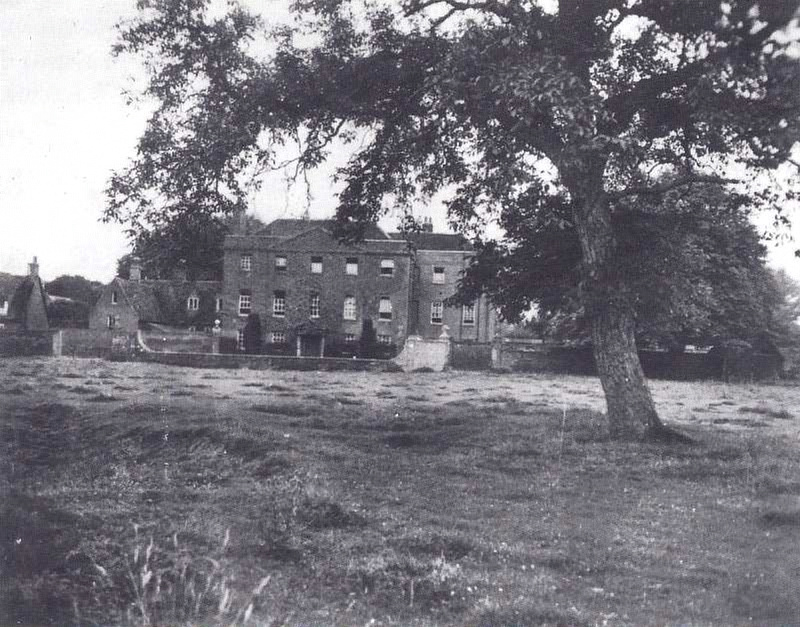
Farm Hall
Huntingdon
Farm Hall is an 18th-century Georgian house on West Street in Godmanchester, beside Huntingdon in Cambridgeshire. It is remembered as the place where British intelligence held German nuclear physicists in 1945. The house is listed Grade II*, but it is privately owned and is not a ticketed attraction. What is Farm Hall and when was it built? The present house dates from 1746, when it was rebuilt for Charles Clarke, Recorder of Huntingdon. It stands at 24 West Street. Historic England added it to the National Heritage List for England (entry 1128580) on 28 November 1950 and rates it Grade II*, a category reserved for particularly important buildings. Why is Farm Hall famous? During the Second World War the property belonged to the British Secret Service. Between July 1945 and January 1946, under Operation Epsilon, ten German scientists suspected of working on Nazi Germany's atomic programme were confined here. Werner Heisenberg and Otto Hahn were among them. The rooms were bugged, because the Allies wanted to learn how close Germany had come to building a nuclear weapon. The recorded conversations, including the men's reactions to news of the Hiroshima bombing, later became an important source for historians of science. Can you visit Farm Hall? No. It is a private home with no regular tours. The best way to see it is from the public street in Godmanchester, with respect for the residents. Please do not enter the grounds or look over the boundary. If you want to see it as part of a history-of-science trip, check beforehand whether the owners have announced any special open days. How do you get there? Godmanchester lies right next to Huntingdon, across the River Great Ouse. From the centre of Huntingdon it is a walk of roughly fifteen minutes to West Street. Trains stop at Huntingdon station, and from there you can take a local bus or taxi. By car, the main roads from Cambridge and Peterborough lead to the area, and parking is easiest in Huntingdon. What else is nearby? Godmanchester has an old town centre with houses from many periods, and a riverside walk along the Great Ouse pairs well with a stroll through Huntingdon. Farm Hall fits in as a stop for anyone interested in 20th-century history or Georgian architecture. Frequently asked questions Is Farm Hall open to the public? No, it is a private residence. You can only view it from the public road. Where exactly is Farm Hall? On West Street in Godmanchester, close to Huntingdon in Cambridgeshire. Who was held there? Ten German scientists linked to the nuclear programme, among them Werner Heisenberg and Otto Hahn, in 1945 and 1946. What heritage status does the building have? It is on the National Heritage List for England as Grade II* (entry 1128580).
-
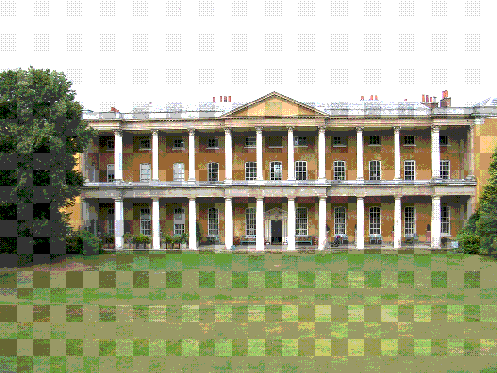
West Wycombe Park House
West Wycombe
West Wycombe Park House is an eighteenth-century country mansion in the village of West Wycombe, Buckinghamshire, in south-east England, built for the Dashwood family. Its architecture runs from early Palladian to Neoclassical, and it ranks among England's most significant houses of that type. What is West Wycombe Park? The first Dashwood baronet began the core of the house around 1710. The real transformation came under Sir Francis Dashwood, 2nd Baronet, who reworked both house and estate between 1735 and 1781 as a kind of pleasure palace. The work stretched over decades, so the different fronts reflect shifting fashions. In 1943 Sir John Dashwood, 10th Baronet, gave the house to the National Trust. The Trust took the building and its pleasure grounds, while the wider estate and the contents stayed with the family, who still live here. How is it protected? The house is Grade I listed, the highest level, since 9 January 1954 (National Heritage List entry 1160521). The landscape park has its own Grade I entry on the Register of Parks and Gardens (1000447, registered 1987). Several estate structures are listed too, including North Lodge and North West Lodge with gatepiers (Grade II*) and the Music Temple. What will you see? The main draw is the whole composition: a Palladian house with grand porticoes, set in a landscape park dotted with temples and garden buildings. Inside, rooms show the family collections and the decorative schemes of Sir Francis's era. The grounds are worth a stroll for the lodges and the Music Temple. When and how can you visit? Access is seasonal, mostly in the summer months and at limited hours. Because the family lives on the estate, some days are closed. Check the National Trust website for current dates and prices before travelling. Outside the season you can still explore West Wycombe village and catch glimpses of the park from the road. What else is nearby? On the hill above the village stand St Lawrence's church, whose tower is Grade I listed, and the Dashwood mausoleum, also Grade I. The village itself, long tied to the family, makes a natural companion to the house visit. The house sits at roughly 51.641 N, 0.804 W. Frequently asked questions Does the National Trust own West Wycombe Park? Yes, the house and grounds passed to the Trust in 1943. The Dashwood family still lives on the estate. Who built the mansion? The 1st baronet began it around 1710, and Sir Francis Dashwood, 2nd Baronet, remodelled house and estate between 1735 and 1781. Is it open all year? No. Opening is limited, mainly to summer and set hours. Check the National Trust calendar first. What is its heritage status? The house is Grade I listed, and the park is a Grade I registered landscape.
-
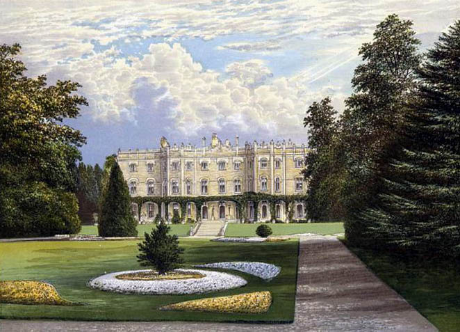
Hughenden Manor
High Wycombe
Hughenden Manor is a Victorian country house in Hughenden, a few kilometres outside High Wycombe in Buckinghamshire. It was the home of Benjamin Disraeli, novelist, Prime Minister and 1st Earl of Beaconsfield. The National Trust now looks after the estate, and the house, gardens and parkland are open to visitors. What is Hughenden Manor? The core of the building dates from 1738. It was extended later in the 18th century, then remodelled around 1860 by the architect E. B. Lamb for Disraeli, giving it its Victorian character. The house is listed Grade I, the highest category on the National Heritage List for England (listed in 1955). The stable block and garden walls hold their own Grade II listing, and the park and garden are Grade II on the national register. What will you see inside? The rooms trace Disraeli's life and career, from his writing to his political rise and his closeness to Queen Victoria. Expect family keepsakes, books, portraits and the study where he worked. A second story sits alongside the first. In 1941 the Air Ministry took over the house for a secret unit codenamed Operation Hillside. Staff drew target maps for bomber crews, and the location suited the work partly because of its proximity to Bomber Command's base near High Wycombe. Everyone involved was bound by the Official Secrets Act, and the house's wartime role only came to light years later. Today an exhibition in some of the rooms tells that story, and the old estate ice house survives in the grounds. Is it worth exploring the park and garden? Yes. Woodland, parkland and walking trails surround the house, and the garden is laid out in a style that echoes Disraeli's era. A walk around the estate pairs well with the house visit and makes a good half-day or full-day outing, including with children. How do you get there? The manor stands on rising ground west of the A4128, the road linking Hughenden with High Wycombe. For satnav use Hughenden Park, HP14 4LA. It is a drive of roughly a quarter of an hour from High Wycombe town centre, and the National Trust runs a car park on site. When should you visit? Opening times for the house, garden and cafe change with the season, so check the National Trust website before you set out. On busy days entry to the house can be limited and handled first come, first served. National Trust members enter free. Frequently asked questions Who lived at Hughenden Manor? Benjamin Disraeli, the British Prime Minister and author, who made it his country home. After his death it stayed in the family until the National Trust took it on in 1947. Is Hughenden Manor a listed building? Yes. The house is Grade I listed, while the park and garden are registered at Grade II. What is the connection with the Second World War? In 1941 the house hosted a secret Air Ministry mapping unit that produced target maps for bomber operations. An exhibition in the house now covers it. Can I visit the manor? Yes. The house, garden and parkland are open to the public. Check the National Trust site for current hours and ticket details.
-
Avon Tyrrell House
Christchurch
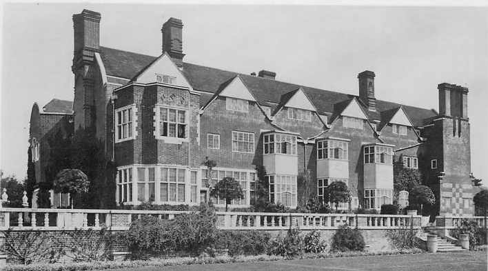
Avon Tyrrell House is an Arts and Crafts manor in the parish of Sopley, Hampshire, on the edge of the New Forest near Christchurch. Designed by W. R. Lethaby, it ranks among the finest houses of the movement and holds Grade I status on the National Heritage List for England, the top tier of protection. How did the house come about? Lord Manners, John Manners-Sutton, commissioned it in the early 1890s. The story goes that he bet he could buy, train and ride the winner of the 1882 Grand National. He won by a short head and put the prize money into a new country house. Sources disagree on completion: 1891 or 1892. What makes the architecture special? Lethaby planned it as a "calendar house", with numbers echoing the year: 365 windows, 52 rooms, 12 chimneys, 7 external doors and 4 wings. It is generally described as the last house of this kind built in England. The brick-walled forecourt, also by Lethaby, is listed separately at Grade II, and so is the surrounding park and garden in the Register of Parks and Gardens. What has it been used for? During the First World War it served as a convalescent home for wounded New Zealand soldiers. In the Second World War the army took it over, using it as an intelligence post and hospital among other roles. In 1946 the property was placed in trust for young people, with the body now called UK Youth as custodian. Princess Elizabeth, later Elizabeth II, opened it in 1949. Can you visit? This is a working residential and outdoor activity centre for young people and groups, not a museum. There are no regular public opening hours, so going inside normally means arranging it in advance with the centre. Most visitors admire it as part of a day in the New Forest area, and it is worth checking the centre's website for current access rules before travelling. How do you get there? The house stands near Sopley, a short distance from Christchurch on the western side of the New Forest. A car is the easiest way to reach it; confirm access to the grounds beforehand. Frequently asked questions Who designed Avon Tyrrell House? William Richard Lethaby, a leading Arts and Crafts architect, for Lord Manners. What does Grade I mean? It is the highest category in the English listing system, reserved for buildings of exceptional national interest. The house was listed on 12 March 1987. Why is it called a calendar house? Its windows, rooms, chimneys, doors and wings match the number of days, weeks, months, days of the week and seasons. Is it a private home today? No. A charity-run centre uses it for education and outdoor activities for young people.
-
Cranbury Park
Winchester
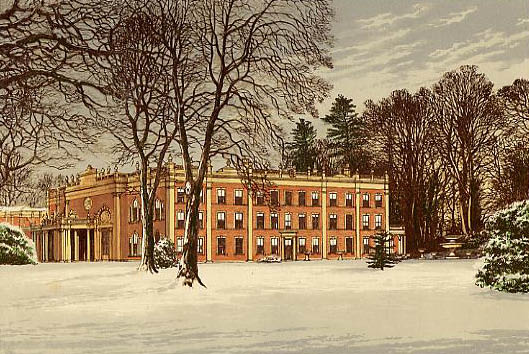
Cranbury Park is a private country house and landscape park in the parish of Hursley, a short drive south of Winchester in Hampshire. The house sits at the centre of a family-run estate that also includes farmland. It is not an everyday ticketed attraction, so it helps to know what to expect before you set out. What is Cranbury Park? A late Georgian mansion surrounded by a broad park, it is recorded on the National Heritage List for England maintained by Historic England. The park has its own separate entry as a registered landscape, shaped mainly in the 1830s. The house dates from the end of the 18th century and was designed by George Dance the Younger. J. B. Papworth reworked the interiors in 1830, the building was extended in the mid-1800s, and it was scaled back in 1960. Who lived here? The estate passed through the Wyndham, Conduit and Dummer families before reaching the Chamberlayne family. Their descendants still own the property and live in the house. Isaac Newton's name is tied to the Conduit family, with whom he stayed in the area, and a sundial in the grounds, dated to the early 18th century, is traditionally linked with him. It is a listed structure in its own right. Can you visit Cranbury Park? The house and park are not generally open to the public. The owners do hold occasional open days, when visitors can enter the grounds. Dates change from year to year, so check current details through Parks & Gardens UK or the estate itself before travelling. On any other day, treat the land as private and stay on public rights of way. How do you get there? The estate lies between the villages of Hursley and Otterbourne, at roughly 51.007° N, 1.366° W. Driving from Winchester takes about fifteen minutes. Local lanes and footpaths pass through the surrounding countryside and give a feel for the landscape, but the house itself is not on view on an ordinary day. What else is nearby? Pair the trip with a walk through Hursley village, in the same parish, and a day in Winchester with its cathedral and medieval centre. The surroundings are classic Hampshire: gentle hills, woods and working farmland. Frequently asked questions Is Cranbury Park open to tourists? Not regularly. The house and park are private, and entry is possible only on occasional open days. Who owns it today? Descendants of the Chamberlayne family, who live in the house and farm the surrounding land. Did Isaac Newton live at Cranbury Park? Newton is connected to the Conduit family, whom he visited, and to a sundial in the grounds. The present house was built after his death. Who designed the current house? George Dance the Younger, at the end of the 18th century, with later interior changes by J. B. Papworth.
-
Poltimore House
Exeter
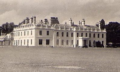
Poltimore House is a historic mansion in the village of Poltimore, just north of Exeter in Devon. For roughly seven centuries it was the seat of the Bampfylde family. Today it is run by a charitable trust, and since the fire of 2024 it stands as a symbol of the effort to save an endangered piece of heritage. What is Poltimore House? The manor of Poltimore belonged to the Bampfyldes from the 13th to the 20th century, and the family was given the title Baron Poltimore in 1831. Richard Bampfylde began the present house in 1550, and its 16th-century core survives within the walls. Sir Coplestone Bampfylde added the south entrance range in the early 18th century, a Rococo saloon enriched the interiors, and a grand staircase followed in the 19th century. The house is Grade II* listed, one of the higher tiers of protection in England. What happened to the house later? The family left in 1921. The building then served as a girls' school, housed Dover College during the war, and became a hospital that stayed open until 1975. After that it stood empty, decayed and suffered repeated vandalism. Building preservation charities took it on in the late 1990s, and Poltimore House Trust has cared for it since around the turn of the millennium, working with East Devon District Council and English Heritage. English Heritage contributed £500,000 towards making the building watertight. What happened in 2024? In the early hours of 9 April 2024 an arson attack destroyed much of the interior. The trust is raising funds to make the house and grounds safe and is developing a realistic plan for restoration. What can you see today? The house is in poor condition and is not a regular interior-tour attraction. Visitors mainly come for the grounds and the exterior, and for occasional events: exhibitions, talks and Heritage Open Days (a history exhibition ran in September 2025). Branches Café on site serves light lunches and refreshments from Thursday to Monday. How do you get there, and when should you go? Poltimore lies a few miles from Exeter, and driving is the easiest option. Free parking is on a grassy area beside the main drive, with accessible spaces behind the café. Aim for the warmer months, and check the trust's website (poltimore.org) beforehand for events and current access. Frequently asked questions Can you go inside Poltimore House? Usually not. The interiors are unsafe after the fire, and entry is limited to selected events run by the trust. Is there an entry charge for the grounds? Parking is free, and many events, including open days, have been free of charge. The trust publishes current terms. Is there somewhere to eat? Yes, Branches Café, open Thursday to Monday. When was the house built? Construction began in 1550, and it was extended many times afterwards, particularly in the 18th and 19th centuries.
-

Wiston House
Steyning
Wiston House near Steyning in West Sussex is an Elizabethan country house from the later 16th century, protected as a Grade I listed building, the highest category in England. It sits inside the South Downs National Park at the foot of the chalk escarpment, at the heart of an estate of more than 2,400 hectares. What is it and who built it? The house dates from around 1576 and was built for Thomas Shirley (also spelled Sherley), a member of the local gentry. During the Civil War it changed hands between Royalist and Parliamentarian forces. Afterwards it passed to the Goring family, who held it for generations. Parts of the original mansion were pulled down in the 18th century, and in the early 1800s the architect Edward Blore reworked the house and added new wings. What you see today is a Tudor core wrapped in later additions. Can you visit Wiston House? It is not a museum with regular opening hours. The house is the home of Wilton Park, an executive agency of the UK Foreign Office that hosts international policy conferences, so the interior is normally closed to the public. Your best chance to get in is a National Garden Scheme open day. The latest one found ran on 12 July 2025, with the garden (a Victorian layout still being restored) and neighbouring St Mary's Church open. Tickets were about £10, children free, and booking was recommended. Check the National Garden Scheme website for the next date. What else is nearby? St Mary's Church beside the house, which holds memorials connected with the estate's owning families. Wiston Estate, which runs a winery and a restaurant open to visitors. Confirm opening times before you go. Chanctonbury Ring, the hilltop crowned with beech trees planted in 1760 by Charles Goring, heir to the estate. It is a classic South Downs walk with wide views over the Weald. How do you get there and when should you go? Wiston lies close to Steyning, just off the A283. The nearest mainline station is Worthing, from where you need a bus or taxi. Walkers heading for Chanctonbury Ring usually start from the free car park near Washington, which is locked at dusk. Summer suits an open day; spring and autumn are better for hill walks, though the descent can be slippery after rain. Frequently asked questions Is Wiston House open to visitors? Not year-round. It operates as a conference centre, and public access is mostly limited to National Garden Scheme open days. What is its listing grade? Grade I, the top tier of protection in England. What is Wilton Park? A UK Foreign Office agency that runs international affairs conferences at Wiston House. Is there a good walk nearby? Yes. Chanctonbury Ring is a popular South Downs hike. The climb is fairly steep but not extreme.
-
Childwickbury Manor
St Albans
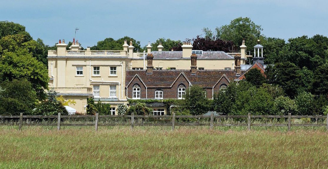
Childwickbury Manor is a historic country house in the hamlet of Childwickbury, Hertfordshire, on the road between St Albans and Harpenden. Historic England lists it as Childwick Bury Manor. These days it is best known as the home of film director Stanley Kubrick, who is also buried on the estate. Can you visit Childwickbury Manor? This is a private estate, not a museum, so there are no regular opening hours or tickets. At most you can see the house from the outside, from public roads or nearby rights of way, without stepping onto private land. Don't count on getting inside the grounds, and check independently for any public events before you travel. How do you get there? The manor sits in the countryside a few miles from St Albans town centre, towards Harpenden. A car or taxi from St Albans is the easiest option. Trains from London reach St Albans, but from there you will need local transport or a bike. The approach is along country lanes, so plan your route in advance. What is the history of the house? According to the heritage listing, the house probably has late 17th-century origins. It was altered in the 18th century, remodelled after 1854 for H. H. Toulman, and extended after 1883 for Sir John Blundell Maple. The entrance front dates from the 1850s and has a Doric porte cochere, a covered carriage entrance. The manor is Grade II listed (listed 19 September 1978) together with its former stable ranges. Other parts of the estate are listed separately: piers and gates from around 1895, the old garden wall, a water tower in the courtyard, and stud buildings such as Stud House and the gate lodges. Why do film fans come here? Stanley Kubrick lived at the manor and rests here. For cinema lovers it is a reason to detour on a day around St Albans, though the appeal is the setting itself, since the interiors are closed to the public. What else is nearby? St Albans has its cathedral, the Roman site of Verulamium and a lively old town. Harpenden is a quiet market town with a large common. The manor fits easily into a walk or a day trip from London. Frequently asked questions Is the manor open to visitors? Not on a regular basis. It is a private estate with no standard visiting hours. Can you see the house from outside? To a limited degree, from public roads and paths, without entering private land. What heritage status does it have? Grade II on the National Heritage List for England, listed in 1978. What is the Kubrick connection? The director lived here and is buried on the estate.
-

Woodcote Park
Epsom
Woodcote Park is a historic country house and estate on the edge of Epsom in Surrey, England. The property covers roughly 350 acres, carries a Grade II* heritage listing and today belongs to the Royal Automobile Club. Its story links English aristocracy, Italian decorative art, two world wars and a museum on the other side of the Atlantic. What is Woodcote Park? The site is a stately home set within a large estate near Epsom. The Grade II* status places the building among England's particularly important listed structures. Ownership today rests with the Royal Automobile Club, the motoring organisation that bought the estate in 1913. Who lived here? Before the club arrived, Woodcote Park served as the seat of several prominent English families. One of them was the Calvert family, the Barons Baltimore. The Calverts were also Lords Proprietor of the colony of Maryland, which ties this corner of Surrey to the early history of English settlement in North America. What did the interior look like? In its heyday the house was known for lavish interiors. It had a gilded library and a number of fine murals by notable Italian artists, among them Antonio Verrio, a painter associated with grand decorative schemes in English houses of the period. What happened to the historic rooms? Most of the historic rooms were taken out after the Royal Automobile Club bought the estate. Whatever survived that process was lost to a fire in 1934. The house you see now reflects its restoration in 1936, so its present look is a twentieth-century rebuilding rather than an untouched original. Is any of the original interior preserved? Yes, in an unexpected place. The interior of one of the original drawing rooms survives in the Museum of Fine Arts in Boston, Massachusetts. For anyone interested in English country house interiors, it is a notable detail that part of Woodcote Park can be seen in the United States. What role did the estate play in the world wars? During the First World War the military used the estate as a convalescent hospital. In both world wars it also served as a training camp. These uses form an important layer of the park's history alongside its aristocratic and motoring chapters. Frequently asked questions Where is Woodcote Park? Near Epsom, in Surrey, England. Who owns it today? The Royal Automobile Club, which purchased the estate in 1913. How large is the estate? About 350 acres. Is the house open to everyone? The estate is in the hands of a private organisation, so check access arrangements with the owner before planning a visit. Why is it connected with Maryland? Because the Calvert family, Barons Baltimore and Lords Proprietor of the colony of Maryland, once held the estate as their seat. When was the present house restored? In 1936, after the fire of 1934. Why it is worth knowing about Woodcote Park is a compact lesson in how an English country house can change over time: from a family seat with painted murals and a gilded library, through service as a hospital and training ground, to its current role under the Royal Automobile Club. Visitors interested in heritage, Anglo-American links or the history of the Epsom area will find it a rewarding subject, even where the original rooms are gone.
-

Albury Park
Albury Park is a country park and historic country house in Surrey, England, close to Guildford. The estate covers more than 150 acres, about 130 hectares. The house is Grade II* listed, and the gardens hold the top Grade I listing on the Register of Historic Parks and Gardens. What is Albury Park? Within the grounds lies the old village of Albury, now just a few houses and a church. The River Tillingbourne runs through the estate. The mix of mansion, formal gardens and the outline of a former village makes it a rewarding stop for anyone interested in English rural history and architecture. Where do the gardens come from? The gardens date back to the 17th century. John Evelyn, the diarist and garden enthusiast, laid out the park with terraces, a canal, a bath and a tunnel. The terraces, the bath house and the tunnel from the mid-1600s still survive. In the 19th century the owner added exotic trees, which gave the park much of its present character. Who remodelled the house? Banker Henry Drummond bought the estate in 1819. Between 1846 and 1852 the house was remodelled by A.W.N. Pugin, the Gothic Revival architect, in a Tudor-Gothic style. The best-known feature is the set of 63 moulded octagonal brick chimneys. The work focused mainly on the exterior, so most of the earlier interiors by Sir John Soane survived. Some critics have judged Pugin's exterior harshly, which adds an interesting talking point for architecture fans. Drummond was also a founder of the Catholic Apostolic Church, and Albury Park became a meeting centre for that group. What happened afterwards? Drummond's daughter Louisa married the 6th Duke of Northumberland in 1845, and the estate passed to the Percy family after Drummond died in 1860. In 1969 the house and six acres of gardens were sold to the Mutual Households Association. The Duke's family still owns most of the land as the Albury Estate. The house has been converted into retirement apartments and conference facilities, so the interiors are not a regular museum open to all visitors. Who is it for? Albury Park suits fans of garden history, Victorian architecture and Pugin's work, as well as anyone planning a quiet day out in Surrey. The riverside setting and the historic village make for a pleasant short walk with a story attached. Check current access arrangements before you go, because part of the land remains private. Frequently asked questions Where is Albury Park? In Surrey, in south-east England, near Guildford. How big is the park? More than 150 acres, around 130 hectares. Who designed the gardens? John Evelyn, in the 17th century. The terraces, bath house and tunnel survive. Who remodelled the house? A.W.N. Pugin, between 1846 and 1852, for Henry Drummond. Can I visit the interiors? The house now serves as retirement apartments and a conference venue, so access to the interiors is limited. Is the site protected? Yes. The gardens are Grade I listed on the Register of Historic Parks and Gardens and the house is Grade II* listed.
-

Adelaide Crescent
Portslade by Sea
Adelaide Crescent is a curved terrace of grand white-fronted townhouses in Hove, the western half of the seaside city of Brighton and Hove. Begun in the 1830s and finished in the 1850s, it is one of the best-known pieces of Regency and early Victorian town planning on the Sussex coast, and a rewarding stop for anyone interested in architecture or simply in a calm walk away from the seafront crowds. What is Adelaide Crescent? It is a residential development laid out as a sweeping arc of terraced houses facing a long garden. The scheme was meant to compete with Kemp Town, the large, upmarket estate on the eastern side of Brighton. The ambition was high, but the crescent was never completed exactly as first planned, because time and money ran short. Who designed it and who paid for it? The architect behind the original design was Decimus Burton, and the developer was Isaac Lyon Goldsmid. The crescent was first named after Queen Adelaide. Nos 1 to 10 date from roughly 1830 to 1840 and follow Burton's design. Work then stalled for a time; one often-told reason is that the neighbouring Anthaeum, a large glasshouse conservatory, collapsed. When building resumed in the 1850s, the remaining houses were put up for the same developer on a different ground plan and in a simpler style. How does it connect to Palmeira Square? To the north the crescent runs straight into Palmeira Square, which was added in the same 1850s phase. Large terraced houses stand on the west and east sides of the square, separated by a public garden. Together the two spaces form one of the most important architectural set-pieces in Hove, and they are best appreciated as a single walk from the sea inland. Is it protected? Yes. Nos 1 to 19 and Nos 20 to 38 are listed at Grade II*, a status that also covers the walls, ramps and stairways on the south front. Adelaide Mansions and the retaining wall have Grade II listing. The gardens of Adelaide Crescent and Palmeira Square appear on the council's local list of heritage assets, and the area lies within the Brunswick Town conservation area. The retaining wall has belonged to the local authority since 1947 and has been showing signs of decay, so restoration has been discussed. What can a visitor do here? The houses are private homes, so the pleasure is in looking from the outside. Walk the curve of the terrace, notice how the earlier and later phases differ, and continue north to Palmeira Square. The location is a short distance from the Hove seafront, which makes it easy to combine with a stroll along the promenade. Frequently asked questions Where is Adelaide Crescent? In Hove, in the English city of Brighton and Hove, close to the seafront. Who designed it? Decimus Burton, with later parts built to a simplified plan. Can I go inside the houses? No, they are residential buildings; enjoy the architecture from the street and the garden area. Is it worth a visit? For architecture fans, yes. It is considered one of Hove's most significant architectural ensembles.
-

Lincoln's Inn
Londyn
Lincoln's Inn is one of the four Inns of Court in London, the professional associations that anyone wishing to practise as a barrister in England and Wales must join. The other three are Middle Temple, Inner Temple and Gray's Inn. For visitors it is above all a quiet, green pocket next to the busy city, with brick courtyards, gardens and buildings that are centuries old. Where is Lincoln's Inn and how do you get there? The estate lies in Holborn, at the heart of legal London, just east of Lincoln's Inn Fields, the largest public square in the capital. The main gate opens onto that square. The nearest Underground stations are Holborn and Chancery Lane, and the British Museum and Covent Garden are only a short walk away. What is the history of Lincoln's Inn? The Inn's continuous records, known as the Black Books, go back to 1422, when the Bishop of Chichester let the site to Lincoln's Inn. Its exact origins remain unclear, but it is among the oldest legal societies in the country. What is there to see? Old Hall – the older hall, dating from the late 15th century, where Charles Dickens set the opening of Bleak House. Great Hall – a Tudor Revival hall designed by Philip Hardwick and built in the 1840s when the old hall became too cramped. A large fresco by G.F. Watts covers the north wall; it took seven years to complete in place, between 1852 and 1859. Chapel – built in the 1620s, reportedly with input from Inigo Jones. It stands on an open undercroft, and its floor is paved with the gravestones of deceased members of the Inn. New Square – originally Serle's Court. Three grand terraces around an open gravelled area were built in the late 17th century by the barrister Henry Serle. In the 19th century the shrubs were pushed to the edges and lawn was laid across the whole square. Gardens – after the Great Hall was built, gardeners George Temple and his son reworked the grounds. The son planted the London plane trees in 1860, replacing earlier elms. Can you visit Lincoln's Inn? It is a working professional home, so normal rules for such places apply. The gardens and courtyards are sometimes open to visitors at set times, while interiors are usually seen on organised visits or during events such as Open House London. Check the official Lincoln's Inn website for current details before you go. Frequently asked questions Is Lincoln's Inn a university? No. It is a professional association for barristers and students training for the bar. It runs a library, dining traditions and education programmes. How long does a visit take? An hour is enough for a stroll through the courtyards and gardens. Allow more time if you enter the chapel or Great Hall. What else is nearby? Lincoln's Inn Fields, with a large lawn for a rest, plus other landmarks of legal and historical London, including the other Inns of Court. Who is it for? Architecture, legal history and literature fans, and anyone looking for calm in the middle of the city.
-

Hanging Stone or Watersheddles Cross
Bradford
Hanging Stone, also known as Watersheddles Cross, is a weathered millstone grit boundary marker standing on the high moorland above Laneshaw Bridge, on the old border between Lancashire and Yorkshire. It is a quiet, windswept spot for walkers who enjoy landscapes with a story behind them. What is the Hanging Stone? The monument is a large block of gritstone that leans at roughly 45 degrees, which explains the name. A cross stands out from the top, and the name is cut into one side. The stone is Grade II listed, and the listing describes it as a boundary marker dating from the 19th century. Local tradition and older descriptions suggest the top was once shaped into an octagon with a raised cross, and that the lettering was added by people from the surrounding area. An early 20th-century account puts its length at about six feet. Where is it, and why does it matter? The stone sits on Oakworth Moor, near Kiln Hill, in the civil parish of Laneshaw Bridge. It lies on the historic line dividing Lancashire from the West Riding of Yorkshire, and today it is also where the Pendle and Bradford local authority areas meet. Published grid references differ by a few metres, so allow for a short search on open moor. A boundary with a long history The marker belongs to a much older story. In 1618 a commission examined a dispute between the Duchy of Lancaster and freeholders from Oakworth. The Lancashire parish of Whalley was said to have held land as far east as the Hanging Stone, and the county line was fixed at Watersheddles Cross. Around the stone there are several other markers. A narrow, unlettered boulder is associated with that 17th-century settlement. Modern concrete posts mark the Lancashire and Yorkshire sides, and another pair names Keighley and Trawden. What can you see nearby? The leaning stone with its carved cross and inscription. Other boundary stones and posts grouped around Watersheddles. Open moorland views across the Pennine watershed, which gives the place its name. Practical tips Conditions on the moor change quickly, so bring waterproofs and sturdy boots. Paths can be boggy after rain, and there are no facilities on site. Carry a map or offline navigation, because the stone is not easy to spot from a distance in poor visibility. Frequently asked questions Why is it called the Hanging Stone? The block leans sharply, so it appears to hang rather than stand upright. Is it a real cross? It is a boundary marker with a cross form carved on top, not a religious monument in the usual sense. Is the Hanging Stone protected? Yes, it has Grade II listed status. Which counties does it separate? Historically Lancashire and the West Riding of Yorkshire. Today it also marks where the Pendle and Bradford council areas meet. Is it worth a visit? For history lovers and moorland walkers, yes. It is a small monument, but it connects directly to centuries of local boundary disputes.
-
Monastic grange at Priory Farm
Monastic grange at Priory Farm is the ruined remnant of a thirteenth-century farm complex in Muggleswick, County Durham, built for the priors of Durham. It is a Grade I listed building and a scheduled monument, and it ranks among the more evocative medieval ruins of the North Pennines foothills. What is a monastic grange? A grange was a farm run by a monastic community. Its job was to supply food and raw materials to the parent house, and any surplus was sold for profit. Durham Priory owned extensive estates across the north of England, and granges like this one turned the land into income and provisions for the monks. Muggleswick was the priory's upland outpost, set in moorland country where grazing and a hunting park were the main assets. Who built it and when? The grange was built by Prior Hugh of Darlington, who held office from 1258 to 1272. It stands on what is thought to be the site of an earlier grange, so the place had agricultural importance for the priory even before his time. In 1259 Prior Hugh received permission to enclose a park here, and the grange stood inside this deer park. That detail shows the site was more than a working farm. It also served as a rural residence and estate centre where the prior and his household could stay. What did it contain? A document from 1464 lists the buildings of the complex: a hall, a chapel, a grange and a dairy. The same record includes repair estimates, which suggests the buildings had already fallen into poor condition by the late fifteenth century. The complex was therefore a mix of living quarters, worship space and farm buildings, a typical arrangement for a major monastic estate centre. What can you see today? The east gable is the only surviving part of the original structure. It stands about 5 metres high and 9 metres long, with short stretches of the south and north walls attached. The surviving masonry points to a building of three storeys, and the architectural historian Nikolaus Pevsner called it impressive. Even in this fragmentary state, the scale of the wall makes it easy to picture how large the medieval hall range once was. The ruins sit beside Priory Farm, so you see them against a working agricultural backdrop, much as they have been used for centuries. Is there a church nearby? Muggleswick has a church dedicated to All Saints. A church was built around 1259 as part of the grange, but the building standing today dates from around 1869 and replaced the medieval one. Visiting: practical questions Is it open? The site can be visited at all times, and there is no ticket office or fixed opening hours. Is there parking? There is a small car park with room for about five vehicles, so arrive early on busy summer weekends. How long does a visit take? The ruin is compact. Most visitors spend 15 to 30 minutes reading the layout and photographing the gable. Combine it with a walk through the surrounding village and moorland to make a half-day outing. Who is it for? It suits anyone interested in medieval history, monastic landscapes or ruins, and photographers who enjoy atmospheric stonework in open countryside. Frequently asked questions Was this a monastery? No. It was a farm and estate centre owned by Durham Priory, not a place where a community lived and prayed full time. Why was a park enclosed here? Enclosed parks were used to keep deer and manage hunting, and they signalled the status of the owner. The prior's enclosure of 1259 fits that pattern. How old is it? The surviving gable dates from the second half of the thirteenth century, so it is more than 750 years old. Is it protected? Yes. It is both a scheduled monument and a Grade I listed building, the highest grade of listing in England.
-
Woodhead House
Clachan of Campsie
Woodhead House is a ruined tower house from the late 16th century, standing in East Dunbartonshire in central Scotland, close to the village of Clachan of Campsie. Roofless and wrapped in ivy, it is a small but characterful piece of Scottish castle architecture, and it is protected as a scheduled monument. What is Woodhead House? Woodhead House was built as a fortified family home of the kind that landowners across Scotland favoured in the 1500s. Records point to John Lennox of Balcarroch as the man who had it built, around 1572. Historic Environment Scotland describes it as a small castle, while the Scottish Places gazetteer calls it an L-plan tower, meaning two rectangular blocks joined at right angles. The monument has had legal protection as a scheduled site since 1995. What does the building look like? The tower rose through three storeys with an attic above. Surveys of the remains describe a barrel-vaulted basement, a kitchen and a cellar on the lower level, and a hall on the first floor, which was the main reception room of a house like this. Canmore, the national record of the historic environment, notes that the design fits a late 16th-century date and that some small alterations were made in the 17th century. Only part of the original structure survives today. Why is only part of it left? The story of the ruin is tied to its much grander neighbour. In the 1830s and 1840s John Kincaid-Lennox built the large new mansion of Lennox Castle nearby, and Woodhead House was originally meant to be pulled down. His wife is said to have persuaded him to demolish only part of it and keep the rest as a picturesque, ivy-covered ruin. During this period the basement was also briefly used as an ice-house, according to Canmore. The ruin stands close to Lennox Castle, across the driveway from it, as a reminder of the older family seat. Where is it and how do you get there? Woodhead House lies roughly a kilometre from Clachan of Campsie, in the countryside at the foot of the Campsie Fells, northeast of Lennox Castle. Wikidata lists its coordinates as about 55.978, -4.235. Check access before you set out, because the ruin is close to the Lennox Castle grounds and conditions around the site may change. Who should visit? The ruin suits anyone interested in Scottish castles, local history or the surviving traces of tower houses from the Renaissance period. It is a short stop rather than a full-day destination, and it combines naturally with a walk around Clachan of Campsie and a look at the nearby Lennox Castle. Frequently asked questions When was Woodhead House built? Around 1572, for John Lennox of Balcarroch. Is Woodhead House a protected monument? Yes. It has been a scheduled monument since 1995. What type of building is it? A small L-plan tower house with three storeys and an attic, now a ruin. Why was it not demolished? When Lennox Castle was built in the 1830s and 1840s, the owner's wife reportedly persuaded him to keep part of the old house as an ivy-covered ruin. Is it the same as the Woodhead Tunnels or Woodhead railway line? No. Those are in the north of England and have no connection to this Scottish tower house.
Earn badges for the places you visit
Download NextOnTrip, discover new places and check off your trails.