About this place
Radhošť is a mountain in the municipality of Trojanovice, part of the Moravian-Silesian Beskids in the eastern Czech Republic. Reaching 1,129 metres (3,704 ft), it has long drawn hikers looking for both open ridge views and a touch of old Slavic folklore.
Where is Radhošť located?
The summit sits right on the boundary between the Zlín and Moravian-Silesian regions, with the administrative border running along the mountain's ridge — a small detail that makes it a bit of a geographic curiosity. Radhošť spans the municipalities of Dolní Bečva and Trojanovice, and the nearest sizeable town is Rožnov pod Radhoštěm, roughly 7 km from the summit.
The wider area belongs to the Moravian-Silesian Beskids, a mid-sized mountain range that trades alpine drama for quiet forested trails and the kind of rolling, wooded scenery typical of Central Europe's mid-mountains.
How do you get to the top?
The most popular approach is the red-marked trail starting in Rožnov pod Radhoštěm — it runs all the way up and ends precisely on the summit of Radhošť, making it a clear, straightforward option for a day hike starting from the valley.
A second option is the blue-marked trail, running west to east. It passes over the nearby peak of Radegast on its way to the Pustevny saddle, a well-known hub for hikers in this part of the Beskids. This route suits anyone wanting to combine the ascent of Radhošť with a longer ridge traverse rather than retracing the same path back down, as is typical of the Rožnov approach.
Both trails follow the well-established Czech waymarking system, so navigation is straightforward even for less experienced hikers.
What's the history behind the name?
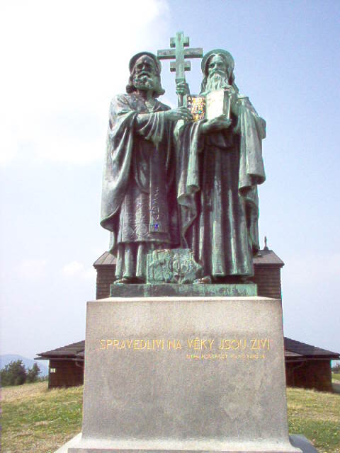
Radhošť has long been associated with Radegast (Radogost), a deity worshipped by the ancient Slavs. Local tradition holds that the summit was a site of his cult, and this legacy is part of why the mountain holds a special place in the regional identity and folklore. The name Radhošť itself is often linked to this heritage.
For visitors, this means a hike to the top is not just a physical outing but also a brush with a layer of local history and mythology — visible even in the naming of nearby features, such as the peak of Radegast that the blue trail crosses on its way toward Pustevny.
When is the best time to visit?
As with most peaks in the Moravian-Silesian Beskids, late spring through early autumn tends to offer the driest, most comfortable trail conditions. Given the ridge sits at 1,129 metres, weather can shift faster up top than it does down in the valley, so it's worth packing layers for changeable conditions regardless of the season.
Frequently asked questions
How high is Radhošť? The summit reaches 1,129 metres (3,704 ft) and belongs to the Moravian-Silesian Beskids range.
Where's the best starting point for a hike up Radhošť? Rožnov pod Radhoštěm is the most convenient base — the red trail from town leads directly to the summit, about 7 km away.
Can you reach Pustevny from Radhošť? Yes — the blue trail running west to east passes over the peak of Radegast on its way to the Pustevny saddle.
Why is the name Radhošť associated with Slavic mythology? According to local tradition, the mountain was once a site of worship for Radegast (Radogost), a deity of the ancient Slavs, which is where the connection to the name comes from.
Nearby places

Earn badges for the places you visit
Download NextOnTrip, discover new places and check off your trails.