About this place
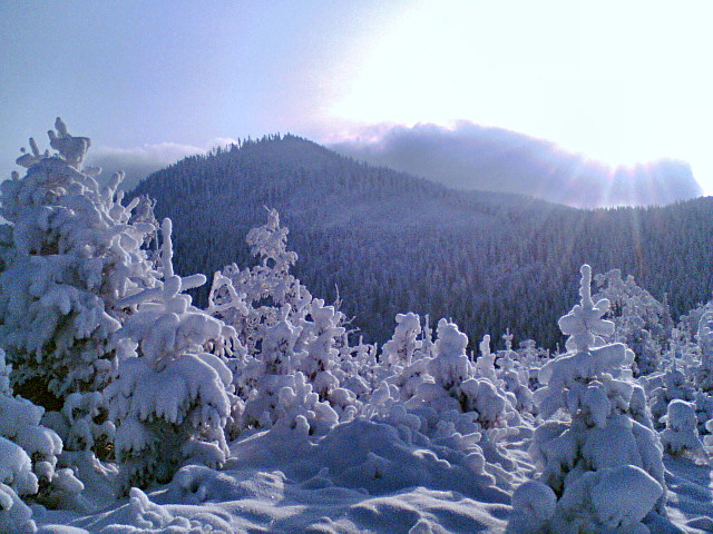
Kněhyně is one of the tallest peaks of the Moravian-Silesian Beskids, rising above the village of Čeladná on the Czech side of the border. At 1,257 metres above sea level, it ranks as the third-highest summit in this mountain range and forms part of the so-called Radhošť Highlands, a subrange known for its dense forests and largely untouched wilderness.
Where is the massif and what does it look like?
Kněhyně forms one large massif together with the neighbouring peak Čertův mlýn, located roughly 6 km southeast of Trojanovice. The valley of the Čeladenka stream, which flows through Čeladná, marks the massif's eastern boundary, while the headwaters of the Bystrá stream border it to the northwest and the springs of the Kněhyně stream to the southwest. The summit itself is built from folded Godula layers — claystones and sandstones — and its uppermost section forms a nearly 150-metre-long plateau with slightly raised edges on either side.
What will you see on the trail?
The entire massif is covered in dense forest, with mountain spruce stands mixed with rowan dominating the highest sections — a landscape typical of the wildest corners of the Moravian-Silesian Beskids. On Kněhyně's southern slope lies Velká Kněhyňská propast, one of the largest caves in the whole Beskid range, discovered in 1963; its steeply inclined corridors stretch for about 250 metres. The ridge connecting Kněhyně and Čertův mlýn falls within the Kněhyně – Čertův mlýn Nature Reserve, which protects the area's natural forests and distinctive terrain.
It's also worth stopping at the saddle below the summit, known as Kněhyně sedlo (1,146 m), where a memorial to partisan Růžena Valentová stands alongside a monument to the 1st Czechoslovak Partisan Brigade of Jan Žižka. Remnants of bunkers in the area testify to partisan activity here during the Second World War.
How do you get to Kněhyně?
Since 2004, no officially marked tourist trail has led to the summit itself, as the terrain falls under nature reserve protection. A worn path to the top still exists, however, and is used by hikers setting out from the surrounding valleys, including Čeladná. A popular route in the area is the red-marked trail that runs through Kněhyně sedlo toward Čertův mlýn and then via Tanečnice to the Pustevny pass — one of the best-known hiking hubs in the Moravian-Silesian Beskids.
When should you visit?
Late spring, summer, and early autumn are the best times to explore this area, when trails are dry and the dense spruce forests are most pleasant to walk through. In winter, the terrain can be more demanding due to steep, forested slopes and the lack of regularly cleared paths.
Frequently asked questions
How tall is Kněhyně? The peak reaches 1,257 metres above sea level, making it the third-highest summit in the Moravian-Silesian Beskids.
Is there a marked trail to the summit? No — since 2004 the area has been protected as a nature reserve and lacks official waymarking, although a worn path exists.
What is worth seeing near the peak? Velká Kněhyňská propast (one of the largest caves in the Beskids), the Kněhyně – Čertův mlýn Nature Reserve, and the partisan memorials at Kněhyně sedlo.
How do you reach the starting point in Čeladná? Čeladná lies in the valley of the Čeladenka stream, at the eastern foot of the massif, making it a natural starting point for hikes toward Kněhyně sedlo and the ridge beyond.
Nearby places

Earn badges for the places you visit
Download NextOnTrip, discover new places and check off your trails.