About this place
Prenet is a 1,071-metre peak in the Šumava (Bohemian Forest) mountains in the Czech Republic, roughly 10 km from Železná Ruda and 7 km southeast of Nýrsko. The mountain marks the southern end of the Pancíř ridge, one of the best-known stretches of the Šumava range, and it's a regular destination for day hikers exploring the area around Železná Ruda.
Where exactly is Prenet?
The mountain actually consists of two summits standing side by side on the same massif: the higher Velký Prenet (1,071 m) and the lower Malý Prenet (1,006 m). Together with Pancíř and Můstek they form a scenic ridge running toward Železná Ruda. Because it sits at the edge of the Šumava range, Prenet offers views in two directions at once — westward across the Český les with the medieval ruins of Přimda castle visible in the distance, and northward over the broad valley of the Úhlava river.
What can you see at the top?
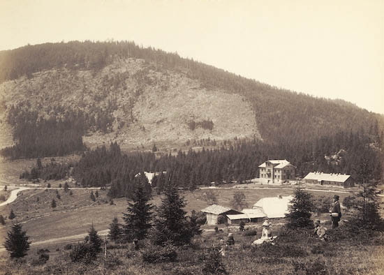
The most memorable stop along the way is the Chapel of St. Kunhuta, standing on a small plateau just below the summit of Malý Prenet. It's a modest historic structure dating from around the turn of the 14th and 15th centuries, once an important pilgrimage site in the region and today a quiet resting point for hikers crossing the ridge. In earlier centuries the summit itself also held a manor connected to the royal administration, later rebuilt for recreational use as a mountain lodge and small hotel serving hikers on the ridge.
How do you get to Prenet?
The best-known approach is the red-marked ridge trail running from Pancíř through Můstek to Prenet — widely regarded as one of the most attractive ridge sections in the whole of the Šumava, mixing open, view-rich stretches with quieter forest paths. An alternative is the green-marked trail starting at Hojsova Stráž railway station, about 4 km away, a convenient option for anyone arriving by train who'd rather not arrange a pickup at a different trailhead. Both routes are well marked and don't require any special mountaineering experience — just the stamina for a few hours of walking over moderately hilly terrain.
When is the best time to visit?
The Pancíř–Prenet ridge is accessible for most of the year, but the most comfortable hiking window runs from late spring through early autumn, when the trails are dry and the views over the Český les and the Úhlava valley are at their clearest. Autumn adds the color of the Šumava forests, while winter turns the same route into a route for cross-country skiers — though that requires proper equipment and preparation.
Who is this hike for?
The Prenet route works equally well for families looking for a calm, full-day walk through the forest and for more experienced hikers planning to cover the entire Pancíř–Můstek–Prenet ridge in one go. The site's history — the old manor, the pilgrimage chapel — gives the walk a layer of context that sets it apart from purely scenic Šumava summits.
Frequently asked questions
How high is Prenet? The main summit, Velký Prenet, reaches 1,071 m above sea level. The neighboring Malý Prenet stands at 1,006 m.
How long does it take to reach the summit? It depends on the route — from Hojsova Stráž (about 4 km) it's a comfortable 1.5–2 hour walk one way. Covering the full ridge starting from Pancíř typically takes half a day.
What else is there to see besides the views? The key historical stop is the Chapel of St. Kunhuta, dating from around the turn of the 14th and 15th centuries — a former pilgrimage site on the plateau just below the summit of Malý Prenet.
Is the route suitable for families with children? Yes, especially the approach from Hojsova Stráž, which is gentle and well signposted, though the longer ridge sections do call for a few hours of sustained walking.
Nearby places

Earn badges for the places you visit
Download NextOnTrip, discover new places and check off your trails.