About this place
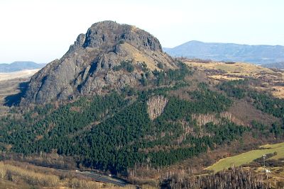
Pohradická hora is a forested basalt hill in the Czech Central Highlands (České středohoří), rising right next to the small village of Úpoř, part of the municipality of Světec in the Teplice district. It isn't among the tallest summits in the range, but it holds something its neighbours don't: the ruins of one of the oldest lookout towers built anywhere in the Central Highlands.
Where does the hill's name come from?
The hill takes its name from Pohradice, a village that once stood at its foot. In 1964, mining operations at the Svornost mine in nearby Ohníč caused the ground to subside, and Pohradice vanished from the map entirely. The hill itself survived and is now one of the few tangible reminders that the village ever existed — locals and hikers regard it as a curiosity of this part of the Central Highlands precisely because of how isolated it stands amid a landscape reshaped by mining.
What's actually left on the summit?
The top of the hill forms a narrow ridge, and each end preserves a different trace of past construction. At one end lie the remains of a perimeter wall that once encircled a lookout tower; at the other, fragments of what is believed to have been an altar or a small chapel. Seeing how little survives of what was once a substantial structure is part of the reason to make the climb.
What was the Aloisova výšina tower?
The tower that once crowned the hill was known as Aloisova výšina, one of the oldest observation towers in the Czech Central Highlands. It was built between 1838 and 1840 on the initiative of the Archbishop of Prague, Alois Josef Schrenk, whose first name gave the tower its title. The structure was a masonry cylinder roughly 15 metres tall and about 6 metres in diameter, spanning what amounted to two storeys and topped with battlements reminiscent of a small fortress. Today only the foundations and a stretch of the encircling wall remain.
What can you see from up there?
Even without the tower, the climb still pays off. From the site of the former altar, the view opens toward Kostomlaty; from where the tower itself once stood, hikers can look out over the Ore Mountains (Krušné hory), the towns of Teplice and Bílina, and the villages scattered across the valley below.
How do you get to Pohradická hora?
The most direct approach is an unmarked path leading straight up from Úpoř. Alternatively, follow the yellow-marked trail that runs between Kostomlaty and Úpoř and branch off toward the hill. The climb itself is short, but since the direct path carries no waymarks, it's worth bringing a map or a GPS app along.
Frequently asked questions
Is the lookout tower still standing? No. Of Aloisova výšina, only the remains of the perimeter wall and the ruins of an altar or chapel at the opposite end of the ridge survive — the tower structure itself is long gone.
Is the route to the summit marked? The direct approach from Úpoř has no trail markings. The safer option is to follow the yellow-marked trail from Kostomlaty to Úpoř and turn off toward the hill from there.
Why is the hill considered a local curiosity? Because of its isolated position next to land where an entire village, Pohradice, disappeared due to mining subsidence, and because it carries the ruins of one of the region's oldest lookout towers.
What else is worth combining with a visit here? The same yellow trail connects to Kostomlaty pod Milešovkou and other viewpoints in the Central Highlands, making it easy to turn the climb into a longer day out.
Nearby places

Earn badges for the places you visit
Download NextOnTrip, discover new places and check off your trails.