About this place
Milíře is the highest summit in the municipality of Albrechtice v Jizerských horách and one of the "thousand-metre peaks" on the Czech side of the Jizera Mountains (Jizerské hory). It rises along the Mariánskohorský ridge a few kilometres south of the Albrechtice village centre, reaching an elevation of roughly 1,002–1,003 metres above sea level.
What will you find at the top?
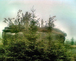
The summit of Milíře has little in common with a neat, well-groomed mountaintop with a viewing platform. Its top consists of several scattered rocky outcrops hidden among the forest — raw, moss-covered granite blocks of a kind found throughout the Jizera Mountains, though few remain quite as hard to reach as these. This is a destination for travelers who value untouched, unmanaged nature over polished tourist infrastructure.
Milíře also functions as a watershed: water flowing from its slopes splits into two separate directions, feeding the Jedlová and Bílá Desná streams. That hydrological role makes the summit an important landmark in the region's topography, even though the peak itself stays largely hidden from view.
How do you get to Milíře?
This is where the real challenge begins. No marked hiking trail leads to the actual summit, and in practice there is no worn path there at all. Anyone determined to stand exactly on the highest point should be prepared to cross forest terrain without a defined route, ideally with a map and compass or a GPS device.
For less determined visitors, a better option is to explore the trails circling the massif from Albrechtice v Jizerských horách — a municipality that stretches from the banks of the Kamenice River (515 m above sea level) all the way up to the Milíře summit, across nearly 2,445 hectares. The village sits in a scenic valley between the Špičák and Mariánská hora hills, and hiking and cycling routes into the heart of the Jizera Mountains start right from there.
When is the best time to visit?
Late spring and summer are the best seasons to explore the Milíře area, when the forest floor is dry and easier to navigate off-trail, along with early autumn, when thinning foliage often improves visibility between the trees. Winter turns the terrain around the summit technically demanding — deep snow combined with the absence of any worn path makes the approach time-consuming and better suited to hikers experienced with wild mountain terrain.
What else is worth combining with the trip?
The area around Albrechtice v Jizerských horách offers plenty to pair with a Milíře excursion. The municipality and its surroundings include viewpoints and ski facilities, so it makes sense to plan the day so that after a demanding approach toward the summit, you descend back toward the village and enjoy the easier, well-marked trail network of the Kamenice valley.
Frequently asked questions
Is there a marked trail to the top of Milíře? No. No marked trail leads to the summit, and there isn't even a worn path on the ground — reaching the highest point means crossing forest terrain without a defined route.
How high is Milíře? The peak reaches roughly 1,002–1,003 metres above sea level, making it one of the Jizera Mountains' "thousand-metre peaks" and the highest point in the municipality of Albrechtice v Jizerských horách.
Why does Milíře matter for the region? The summit forms a watershed between the Jedlová and Bílá Desná streams, giving it hydrological significance for the wider Jizera Mountains area, even though the peak itself is hard to reach.
Where's the best place to start a trip toward Milíře? Albrechtice v Jizerských horách is the natural starting point, with hiking and cycling trails leading toward the massif, while the Kamenice river valley offers an easier, well-marked alternative for less experienced visitors.
Nearby places

Earn badges for the places you visit
Download NextOnTrip, discover new places and check off your trails.