About this place
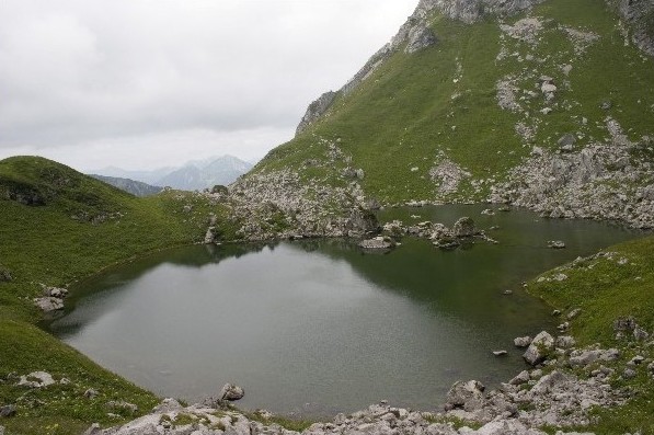
Lac de Darbon is a small mountain lake in the commune of Vacheresse, in the Haute-Savoie department of the French Alps. Sitting at 1,813 metres above sea level, it lies at the heart of the Chablais massif, close to the Swiss border and the Abondance valley. The lake covers roughly 2 hectares — a modest sheet of water whose appeal has less to do with size than with setting, tucked into a hollow beneath the peaks of Dent d'Oche and Château d'Oche, surrounded by the open mountain pastures typical of this corner of the Alps.
Where exactly is the lake?
Lac de Darbon lies within the commune of Vacheresse, in the area known as Bise, one of the more remote pockets of the Chablais, bordering the Abondance valley. Its coordinates are approximately 46.3436°N, 6.7478°E. The surrounding pastures fall within a Natura 2000 protected zone and the Chablais UNESCO Global Geopark, reflecting the ecological value of the alpine flora and fauna found here.
How do you get there?
Most visitors start from the Chalets de Bise, a cluster of mountain pasture huts above Vacheresse reachable by road from late April to late November — outside that window, snow closes the access road. Coming from Thonon-les-Bains, the route runs toward Châtel, then turns off toward Vacheresse and continues to Bise. From the Chalets de Bise, a footpath leads up to the lake itself; there is no direct vehicle access, so the final stretch has to be covered on foot across the high pastures.
What does the hike look like?
The classic option is a loop over three mountain passes: first the Col de Bise, then the Col de Pavis, on to the lake, and finally the Col de Floray, from where the trail descends back to Bise. The full loop covers about 6.7 km with roughly 650 metres of elevation gain, putting it in the medium-difficulty category and taking most walkers three to four hours. The final descent can be steep and slippery after rain, which is why locals recommend tackling this hike only in dry conditions.
What is there to see along the way?
The trail crosses classic Chablais mountain pastures, grazed by cattle in summer and scented with alpine herbs. Along the way, the jagged limestone faces of Dent d'Oche and Château d'Oche dominate the skyline — two of the most recognisable summits in this part of the Savoy Alps. The lake itself, though small, rewards the effort: its still surface often mirrors the surrounding ridgelines, an effect best seen early in the morning or in the late afternoon light.
Who is this hike suited for?
This is a route for hikers already comfortable with mountain walking rather than a casual stroll for young children, though no climbing skills are required. Sturdy trekking shoes and poles are advisable, especially on the steep, rocky sections of the descent.
FAQ
How high is Lac de Darbon? The lake sits at an altitude of 1,813 metres above sea level.
How big is the lake? It covers approximately 2 hectares, making it a small alpine lake rather than a large body of water.
Where should I start the hike? Most people set off from the Chalets de Bise above Vacheresse, reachable by road from late April to late November.
How long does the hike take? The full loop over three passes (Col de Bise, Col de Pavis, Col de Floray) usually takes three to four hours and covers about 6.7 km.
Is the trail difficult? It is a medium-difficulty route with around 650 metres of elevation gain. The descent can be steep, so it's best avoided in wet weather.
Is the area environmentally protected? Yes, the surrounding pastures lie within a Natura 2000 site and the Chablais UNESCO Global Geopark.
Nearby places

Earn badges for the places you visit
Download NextOnTrip, discover new places and check off your trails.