About this place
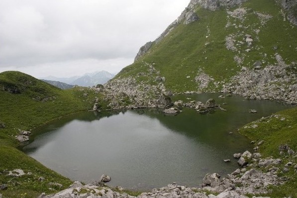
Lac d'Arvouin is a small mountain lake sitting at 1,663 m of altitude, just south of the Cornettes de Bise summit, in the commune of La Chapelle-d'Abondance in Haute-Savoie. The lake covers roughly 1.8 hectares and reaches a maximum depth of 6.3 m. It sits between the peaks of Pointe d'Arvouin and Le Linleu, within a Natura 2000 protected area covering the Cornettes de Bise massif, in the Auvergne-Rhône-Alpes region.
How do you get to Lac d'Arvouin?
The usual starting point is the car park at Sevan, at the end of the road leading out of the centre of La Chapelle-d'Abondance (coming from Abondance, turn left just past the village and follow the road to its end). From there, a gentle, largely flat path leads to the lake in about half an hour. The gradient is mild enough that families with young children manage it comfortably, and parts of the trail are even passable with an all-terrain stroller. That makes the walk to the lake one of the more accessible outings in the Portes du Soleil area, despite its mountain setting.
What is there to see once you arrive?
The lake is known for its turquoise-tinted water, set against green slopes and rocky ridgelines. From its shore, walkers get open views toward the Cornettes de Bise massif, and on a clear day the Abondance valley and the village itself are visible in the distance. The lakeside is a natural resting point for many hikers before deciding whether to continue further uphill.
Can you continue toward Pointe d'Arvouin or Cornettes de Bise?
Yes. A trail continues from the lake up toward the ridge and Pointe d'Arvouin. The full loop, combining the walk to the lake with the climb to the ridge, runs about 7 km with roughly 430-500 m of elevation gain, taking around two and a half hours round trip. More ambitious hikers can push on to the summit of Cornettes de Bise (2,432 m), turning the outing into a full, demanding day in the mountains.
When is the best time to hike here?
The hiking season around Lac d'Arvouin generally runs from late May to late October, though exact dates shift from year to year depending on snow cover — the higher sections of trail can stay snow-covered well into spring.
What wildlife might you spot along the way?
The Natura 2000 area surrounding the lake is home to chamois, marmots and black grouse. Abondance cattle graze the nearby alpine pastures in summer, and higher up the slopes it's also possible to come across chamois and mouflon.
Frequently asked questions
How long does it take to reach the lake? From the Sevan car park, the walk to the lake takes about 30 minutes along a gentle, wide path.
Is the trail suitable for children? Yes, the section to the lake itself is easy and safe for families, though continuing toward the ridge requires more fitness and mountain experience.
Where should I park? The most convenient starting point is the car park at Sevan, at the end of the access road from La Chapelle-d'Abondance.
Can you reach the summit of Cornettes de Bise from the lake? Yes, the trail continues from the lake toward the ridge and on to the summit of Cornettes de Bise (2,432 m), though this extends the outing into a demanding, full-day hike.
How big and how deep is the lake? Lac d'Arvouin covers about 1.8 hectares and reaches a maximum depth of 6.3 m.
Nearby places

Earn badges for the places you visit
Download NextOnTrip, discover new places and check off your trails.