Monuments in Switzerland
A guide to 53 Monuments in Switzerland — with descriptions, photos and traveler visits from the NextOnTrip community. Locations spread across 48 cities and towns. Most visited by the community: Burg Friesenberg, Medieval Castle ruin Neuburg, Montorge castle ruin.
-
Breitenlandenberg ruins
Oberhofen
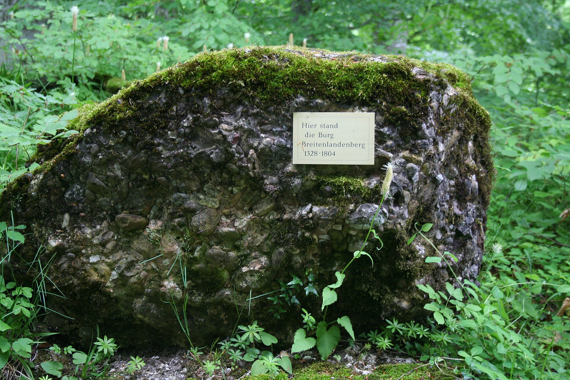
Breitenlandenberg ruins are the remains of a medieval castle standing about 150 metres above the village of Turbenthal in the canton of Zürich, Switzerland. Little is left today: a few wall fragments, the old moat and a deep neck ditch that cut the castle off from the rest of the hill. Even so, it makes a rewarding short outing for anyone interested in regional history and quiet walks in the green Töss valley. Where are the ruins and how do you find them? The ruins sit on a hill south-east of Turbenthal's centre. The castle once overlooked the settlement and the route through the valley. The walk up from the village is short, and the surviving moat and neck ditch show clearly how the defenders secured the one approachable side of the hill. Who built the castle? The castle was built in the first half of the 14th century by Beringer II and Hugo I of the Landenberg family, on land held as a fief of the Abbey of St. Gallen. The Landenbergs, Habsburg retainers, built up a judicial lordship around Turbenthal during the 14th century, and it came to be called Breitenlandenberg after their seat above the village. From 1328 Hermann von Landenberg took his name from this very castle. What did the fortress look like? The complex had a square keep and a courtyard measuring roughly 20 by 24 metres, enclosed by a wall up to two metres thick. In the later 16th century Hans Rudolf von Breitenlandenberg (1542–1608) had multi-storey residential buildings added, turning the stronghold into a more comfortable residence. Why did the castle disappear? In 1710 the estate passed by marriage to Heinrich Werdmüller. After his financial decline it was auctioned off for demolition around the turn of the 19th century. The stones were reused to build Turbenthal's first cotton spinning mill, a neat illustration of how a medieval seat gave way to the valley's early industry. Sources give slightly different dates for the demolition (1801 or 1804), and one notes that a servants' building of the outer bailey survived. Archaeological work During the winter of 1924–1925 excavations uncovered the foundations of the buildings. That work revealed the castle's layout, even though only a small part of it is visible above ground today. Frequently asked questions Is much of the castle left? No. You will mainly see low wall remains and traces of the moat and neck ditch. Who owned it? First the Landenberg family as vassals of the Abbey of St. Gallen, then the Werdmüller family after 1710. What was built from the castle's stones? Turbenthal's first cotton spinning mill. Is it worth visiting? Yes, if you enjoy the history of Swiss knightly families and want a short, peaceful excursion not far from Winterthur and Zürich. Do not expect developed tourist facilities; this is a place for a quiet moment with the region's past. Practical tips Wear sturdy shoes, as the path climbs the hill and can be damp after rain. The ruins combine well with a stroll through Turbenthal and the surrounding woods. Spring and autumn are especially scenic, and the low walls are easier to see when the trees are not in full leaf.
-
Castelgrande
Bellinzona
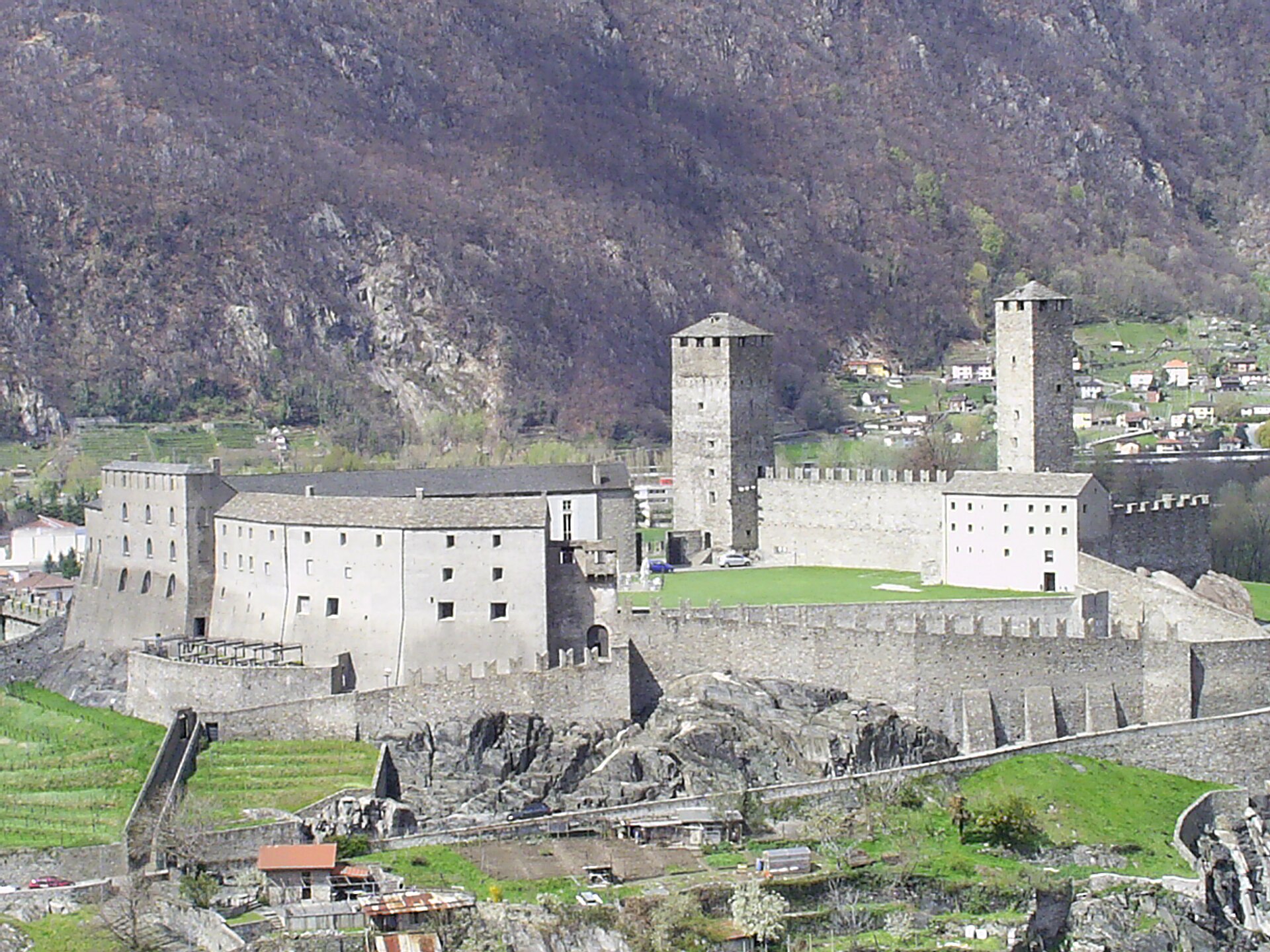
Castelgrande is the largest and oldest of the three castles of Bellinzona, a town in the Swiss canton of Ticino. The fortress sits on a rocky hill above the town and has guarded the route from the Ticino river valley toward the Alpine passes for centuries. Together with Montebello and Sasso Corbaro castles and the defensive walls, it forms a group inscribed on the UNESCO World Heritage list. Why visit Castelgrande? It is Bellinzona's main attraction and the best starting point for understanding the whole fortification system. From the walls and courtyards you get views over the town's rooftops and the wide valley, and the castle's massive outline is visible from far away. After thorough reconstruction and restoration, the site can now be seen in its full splendour. What is the history of the castle? The hill was inhabited long before the fortress was built. Archaeologists have found traces of human presence reaching back some 6,500 years, to the first Neolithic villages. The castle itself is regarded as the oldest of Bellinzona's three strongholds and dates back to the Middle Ages, while most of the defensive system seen today was built in the 15th century, largely by the Dukes of Milan. The fortifications were meant to control the route from the Ticino valley, access to the Alpine passes and the trade traffic to and from the Gotthard Pass. Castelgrande later served as a ducal fortress. Between 1980 and 1991 the Swiss architect Aurelio Galfetti restored the castle. Modern elements blend with the old walls, turning the historic complex back into a living part of the town. What can you see inside? The castle houses a museum spread over two floors. Its archaeological section tells the story of 6,500 years of human presence on the hill, from the Neolithic to the 20th century. Temporary exhibitions are held regularly. Within the fortress, it is worth walking along the walls and courtyards and looking out for the two characteristic towers, known as Torre Nera and Torre Bianca. UNESCO listing The castles and walls of Bellinzona were added to the World Heritage list on 30 November 2000 under the cultural category (criterion iv). The group is an example of medieval defensive architecture set within an Alpine landscape. Frequently asked questions Where is Castelgrande? In Bellinzona, the capital of the canton of Ticino in southern Switzerland, on a hill overlooking the old town. Is Castelgrande a UNESCO site? Yes, together with Montebello and Sasso Corbaro castles and the town walls. Which is the oldest castle in Bellinzona? Castelgrande is considered the oldest. What is there to see inside? A museum with an archaeological section, temporary exhibitions, and walls and courtyards with views over the valley. Is it worth seeing the other castles? Yes. Montebello and Sasso Corbaro complete the picture of the old defensive system, and together with Castelgrande they form a coherent whole. Check current opening hours with the local tourist office before your visit.
-
Gestelnburg
Niedergesteln
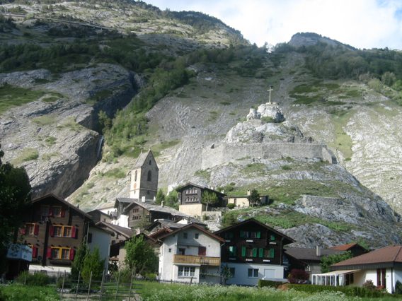
Gestelnburg is a ruined medieval castle above the village of Niedergesteln in the Swiss canton of Valais. It sits on a rocky ridge called Feschti, high above the Rhone valley, and is listed as a Swiss cultural property of national importance. Who built Gestelnburg? The castle went up in the 12th or early 13th century, built by the powerful Barons de la Tour, known in German as the Herren vom Turn. The family held sway over the surrounding area and ruled their lands from this ridge for generations. Why is the castle in ruins? The family's rule ended during the wars against the bishop of Sion in the second half of the 14th century. In 1384 the Upper Valaisans destroyed the castle. It has stood as a ruin ever since, and what remains are mainly wall sections and foundations. Restoration and access Exactly 600 years after the destruction, in 1984, a project began to secure the ruins and make them easier to reach. The foundation Pro Castellione carried out the research and conservation. As a result, visitors can today explore the remains and enjoy the views from the ridge. What else is there to see? The Feschtiloch cave Behind the castle lies a cave called Feschtiloch, which dates back to the last ice age. Its name echoes the Feschti ridge, a word probably derived from "Festung", meaning fortress. Castle and cave together make a rewarding short outing, where medieval history meets geology. Frequently asked questions Where is Gestelnburg? Above Niedergesteln in Valais, southern Switzerland, on the Feschti ridge. When was the castle destroyed? In 1384, after the Barons de la Tour's wars with the bishop of Sion; the Upper Valaisans destroyed it. Is Gestelnburg protected? Yes, it is a Swiss cultural property of national importance. Is there a cave nearby? Yes, the Feschtiloch cave lies behind the castle and dates from the last ice age. Can tourists visit the ruins? Yes. The project begun in 1984 was meant precisely to make the ruins more accessible to visitors. Summary Gestelnburg suits castle lovers, fans of Swiss history and anyone drawn to Valais scenery. The modest ruins on a rocky ridge tell the story of a mighty family's fall, and the nearby cave adds extra character to the visit.
-
Sissacherfluh Ruin
Sissach
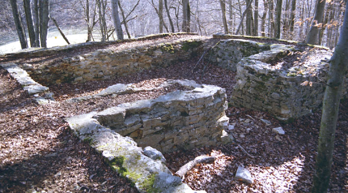
Sissacherfluh Ruin is the site of a hilltop refuge fort on a rocky height above the town of Sissach in the canton of Basel-Landschaft, northern Switzerland. Many lists call it a castle ruin, but it was really a place of refuge and lookout, used across several eras. Where is Sissacherfluh and how do you get there? The hill rises directly above Sissach, in the Baselbiet region of the Tabular Jura. Its coordinates are roughly 47.480° N, 7.817° E. It makes a short walking destination from town, with wide views over the surrounding countryside from the top. What is the history of the site? Archaeologists link the earliest human activity to the Late Bronze Age. Limited traces of post-built houses in the western part of the enclosure point to an early settlement phase. A report by Basel-Landschaft archaeology dates a longer occupation to roughly 1000 to 800 BC. The main fortification was most likely built in the Early Middle Ages. A defensive wall closed off the gentler northern side and enclosed about 2.8 hectares. The steep southern, eastern and western slopes protected themselves and needed little artificial defense. How was the hill used in the early modern period? During the Thirty Years' War the site became a high-watch station. By 1668 at the latest, a signalling chain was operating here, passing warnings between hilltops. The post consisted of a small guardhouse, a double rampart with a palisade, and a shield house at the gate. It was staffed by about four people. Is it a castle or a hill-fort? Sources frame it differently. English Wikipedia classes it as a castle, while archaeological accounts stress its character as a fortified refuge from the Early Middle Ages. For visitors, that means no towers or halls, but the traces of ramparts and old defenses in naturally defensible terrain. How is it different from Bischofstein Castle? Sissacherfluh should not be confused with Bischofstein, which stands on the Chienberg ridge near Sissach. Several castles were built there from the early 12th century, and the last was damaged in the 1356 Basel earthquake and then abandoned. It is an entirely separate site. Frequently asked questions Is Sissacherfluh a real castle? Not really. It is a defensive hill and refuge, though it often appears on castle-ruin lists. Which periods left traces here? The Late Bronze Age, the Early Middle Ages and the early modern period, when a signal post operated here. How large was the fortified area? About 2.8 hectares, with a wall on the northern side. Is it connected to Bischofstein? No, that is a separate site on a different ridge nearby. What is worth seeing? Remains of the ramparts, the naturally steep slopes and the view over the valley around Sissach.
-
Château with St. Alban Chapel
Erlen
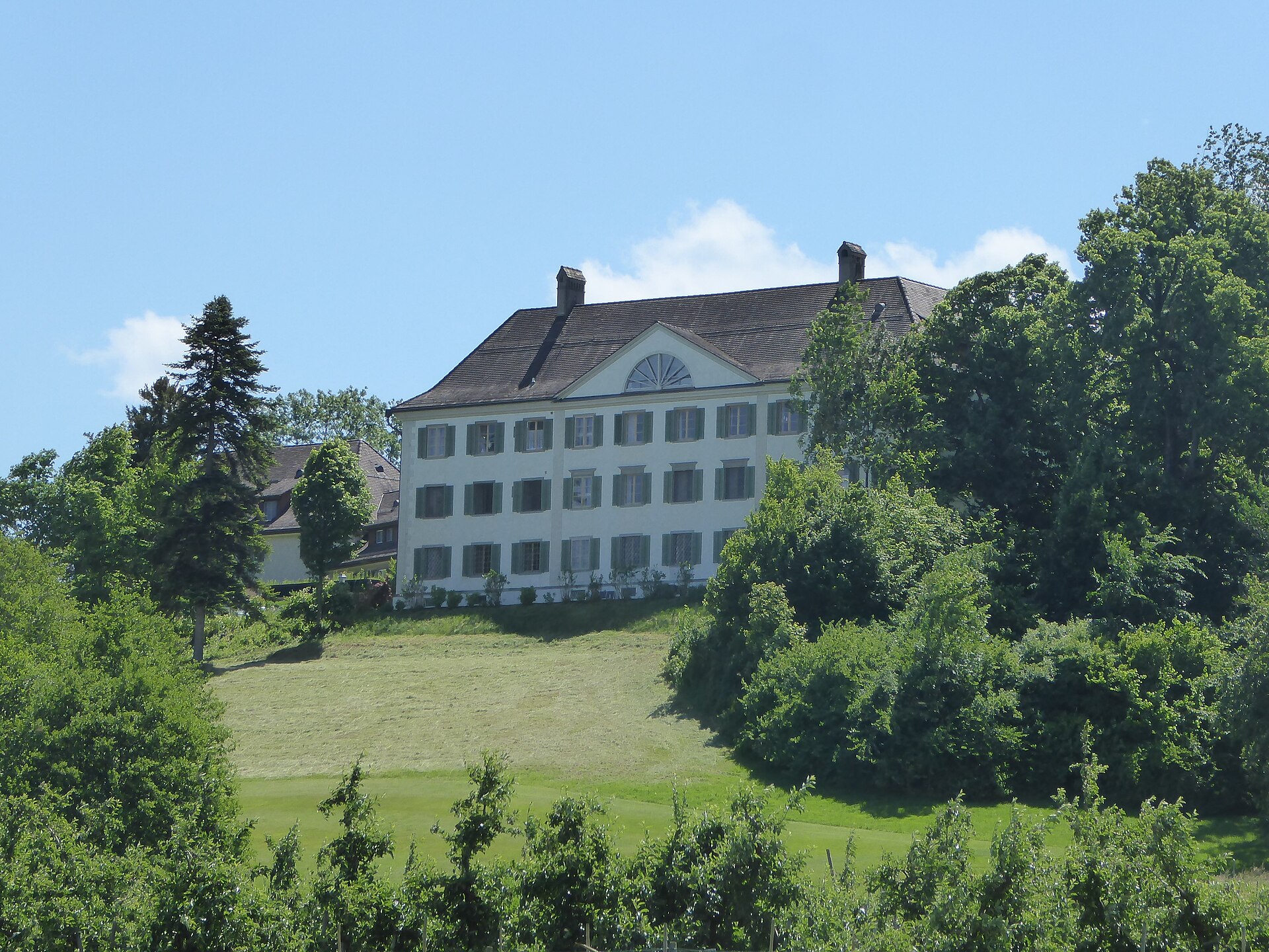
Château with St. Alban Chapel is a historic residence in Eppishausen, part of the municipality of Erlen in the Swiss canton of Thurgau. It combines old manorial architecture with the daily life of a religious community, and its courtyard chapel is among the most interesting parts of the whole complex. What is the château in Eppishausen? The château is a residential complex arranged around a courtyard in eastern Switzerland, near Erlen. In 1698 the Benedictine monastery of Muri bought the estate and kept it until 1808. During that period it served as a residence and administrative centre of the monks' property. After the monastery lost it, the château passed through the hands of several private families. What is the history of St. Alban Chapel? The chapel stands in the château courtyard and is dedicated to Saint Alban. It was built anew at the end of the 17th century, when the estate came to Muri, replacing an earlier medieval chapel with the same dedication. In the 18th century the building was reworked in the Rococo style, giving it the light, ornamental character typical of that era. Its fortunes were uneven. Between 1838 and 1942 no services were held there, and the interior decayed and was used as a storeroom. In 1942 the then owner, Eggebert von Heeren, had it put back in order. After a further renovation, Auxiliary Bishop Martin Gächter reconsecrated the chapel in 1998, returning it to full liturgical use. Who lives in the château today? The château is home to the Catholic community of the Bonitas Dei Sisters. Since 2009 members of the missionary community "Familie Mariens" have lived there too. Next to the château stands a care home for the elderly, which the sisters built in 1977. The site is therefore a living place rather than a museum, which is worth remembering when planning a visit. Heritage significance The château complex with its chapel is listed in the Thurgau cultural property inventory as a class B object, meaning it is of regional importance. The chapel is recorded in it as a separate part of the ensemble. Frequently asked questions Where is Eppishausen château? In Eppishausen, in the municipality of Erlen, canton of Thurgau, eastern Switzerland. Who is the chapel dedicated to? Saint Alban. The medieval chapel that preceded the present one had the same dedication. When was the chapel out of use? From 1838 to 1942 it was not used for worship. It was restored in 1942 and reconsecrated in 1998. Does anyone live in the château? Yes. The Bonitas Dei Sisters and members of the "Familie Mariens" community live there, and a care home for seniors stands alongside. Is the château a protected monument? Yes. It is listed in the Thurgau cultural property inventory as a class B object of regional significance. Who owned the château? The Benedictine monastery of Muri from 1698 to 1808, followed by several private families. Eppishausen is a good stop for anyone interested in sacred history and the architecture of rural manors in Thurgau. Because the château is a home to religious communities, visitors exploring the surroundings should keep quiet and respect the residents.
-
Medieval Castle ruin Neuburg
Mammern
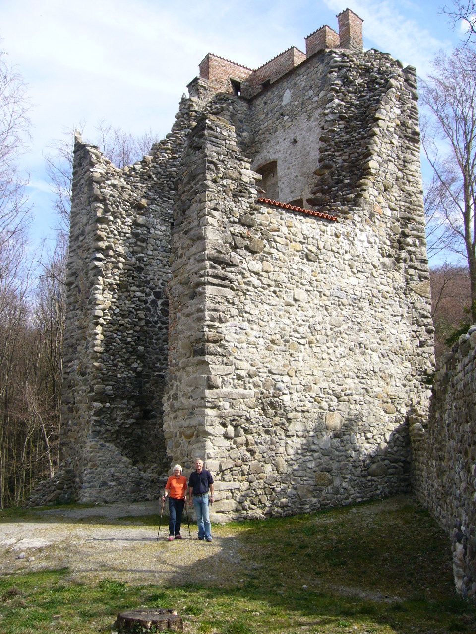
Neuburg castle ruin rises above the village of Mammern in the canton of Thurgau, on the Swiss shore of Lake Constance. Regional sources describe it as the largest and best-preserved castle complex on the southern shore of the Untersee, the lower arm of the lake. For anyone interested in medieval fortifications, it is a rewarding stop in the area. Where is Neuburg? The ruin stands above the village of Mammern, on the southern side of the Untersee in north-eastern Switzerland, at roughly 47.648° N, 8.94° E. The surrounding Thurgau-Bodensee region is known for gentle hills, orchards and lake views. What is the history of the castle? Mammern first appears in records in 909 as Manburron, when it was acquired by the Abbey of St. Gallen. According to available accounts, the abbey ruled over Mammern and Neuburg until the 12th century. In 1319 the lords of Kastell near Tägerwilen received the lordship of Mammern as a fief from the monastery of St. Gallen. They also owned Neuburg above the village. Ownership continued to change over the following centuries. In the 17th century the brothers Johann Peter and Karl Emmanuel von Roll built a new castle in Mammern, which became the property of Rheinau monastery in 1687. Sources give slightly different dates for this work (one mentions 1621), so treat them as approximate. In 1866 Dr. Freuler bought that later castle and opened a private clinic in it. A successor institution still operates in Mammern today. What can you see today? The medieval walls of Neuburg are a ruin, yet they are preserved well enough to be regarded as the most important site of their kind on the Untersee. Conservation work on the ruin was carried out in 2001–2003 and documented in 2004 in the journal of the Swiss castle association. Frequently asked questions Where is Neuburg castle? Above the village of Mammern, in the canton of Thurgau, on the southern shore of the Untersee in Switzerland. Is Neuburg a ruin? Yes, it is a medieval castle ruin, considered the best preserved on this stretch of the lake shore. Who owned the castle? First the Abbey of St. Gallen; from 1319 the lords of Kastell held the lordship of Mammern, including Neuburg, as a fief. Was the ruin restored? Yes, conservation work took place in 2001–2003. What is the castle in Mammern village itself? It is the later castle built by the von Roll brothers, home to a private clinic since 1866. It should not be confused with the medieval Neuburg.
-
Castell Castle
Tägerwilen
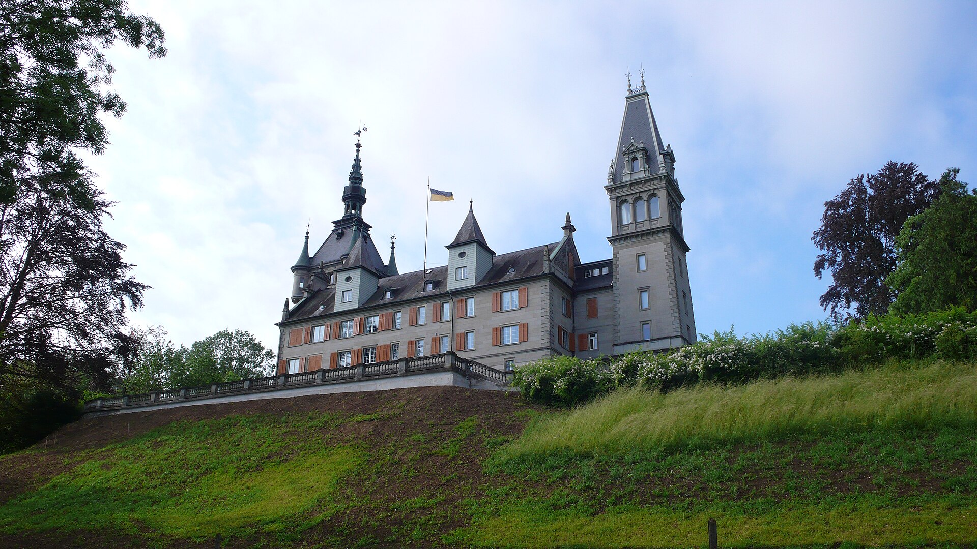
Castell Castle (Schloss Castell) stands in the municipality of Tägerwilen in the canton of Thurgau, in north-eastern Switzerland, close to Lake Constance. It is listed as a Swiss heritage site of national significance. East of the present-day residence lie the ruins of a 12th-century fortress, regarded as one of the largest medieval defensive structures in the Lake Constance region. What is Castell Castle? The name covers two separate buildings. One is the ruin of the old stronghold; the other is the later manor built beside it, which remains a private home today. Together they let you follow the site from medieval fortification to a later country estate. What was the medieval fortress like? It was raised in the early 12th century by Ulrich I, Bishop of Constance, to hold the lakeside territory, and it ranked among the biggest defensive complexes in this part of Europe. From 1175 the Herren von Kastel, a noble family that took its name from the seat, appear in the records. The fortress was destroyed in 1499 during the Swabian War and was never rebuilt as a stronghold. What remains are the ruined walls, a popular stop on walks around Tägerwilen. How did the present residence come about? In 1585 an official from Constance, Junker Konrad, replaced an earlier farmhouse on the spot with a Renaissance manor. That building still forms the core of the complex. In 1790 the estate passed to Daniel von Scherer of St. Gallen. In the 1870s Baron Max von Scherer-Scherburg had the house converted into a Neo-Renaissance castle, which gave it the picturesque look it has today. In 1901 a Scherer heir handed the property to the von Stockar family, who own it to this day. Can you visit Castell Castle? The residence is private property, so the interiors are not open like a museum. It is best admired from the outside, from the surrounding paths. The ruins of the old fortress lie in the eastern part of the site and can be reached on a walk from Tägerwilen. The area is part of local hiking routes, and a lookout tower known as the Napoleonturm stands nearby. Why stop here? You see a 12th-century ruin and a Neo-Renaissance castle side by side. The site is a clear witness to the history of the Bishopric of Constance and the Swabian War of 1499. Its position by Lake Constance makes it easy to combine with a walk or a day out around Konstanz. Frequently asked questions Where is Castell Castle? In Tägerwilen, canton of Thurgau, Switzerland, near Konstanz and Lake Constance. When was the medieval fortress built? In the early 12th century, on the initiative of Ulrich I, Bishop of Constance. Who destroyed the fortress? It was destroyed in 1499 during the Swabian War. Who lives in the castle today? The residence has belonged to the von Stockar family since 1901 and is private. Is the castle a protected monument? Yes, it is listed as a Swiss heritage site of national significance.
-
Alt-Eschenbach, medieval abandoned city, castle ruins
Inwil
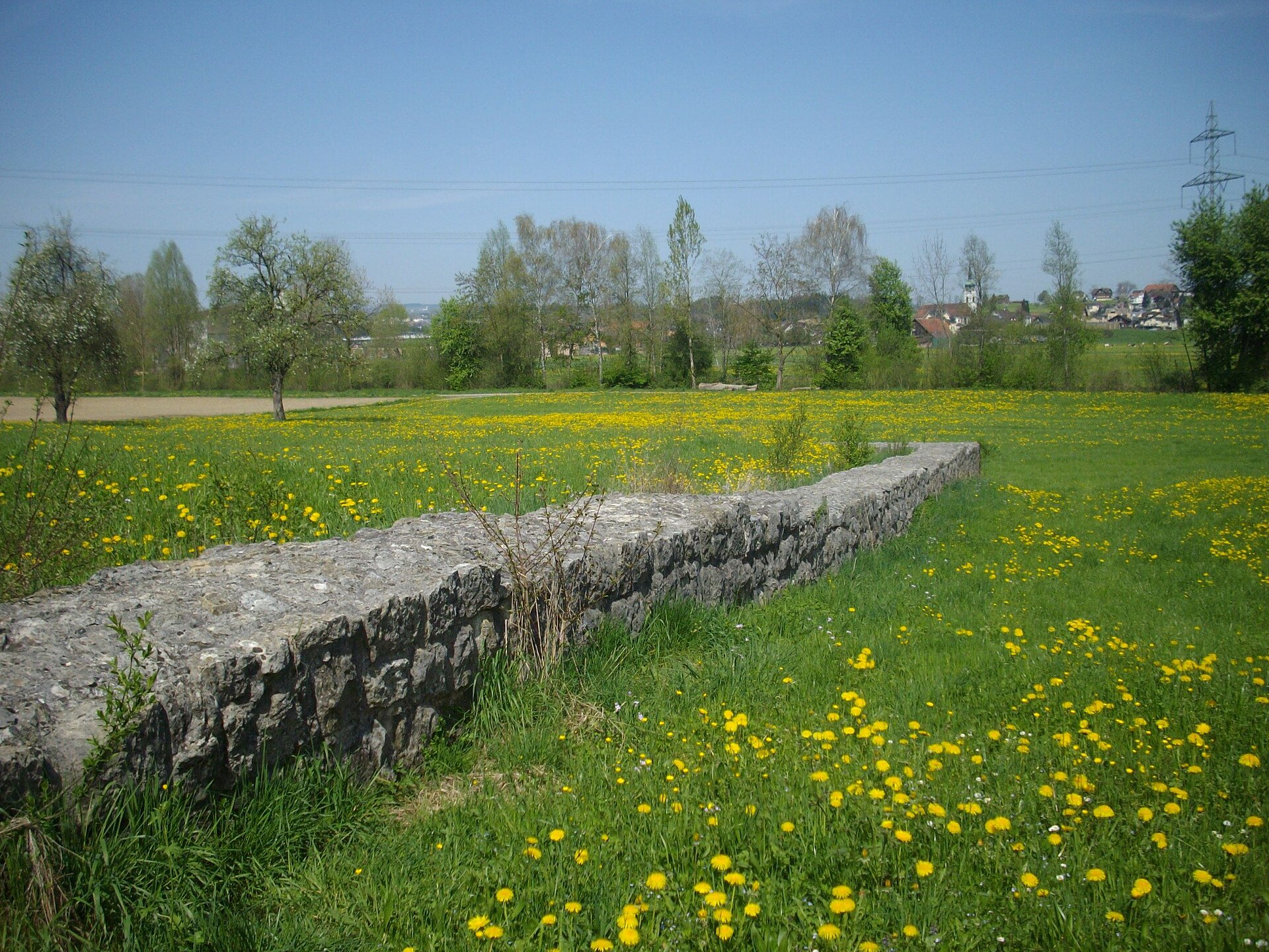
Alt-Eschenbach is the ruin of a medieval tower castle and a small fortified town in Inwil, in the Swiss canton of Lucerne. It is an archaeological site that preserves the memory of the Eschenbach noble family and of a settlement erased from the map in the early 14th century. What is Alt-Eschenbach? Alt-Eschenbach was a castle with an attached town, founded by the Freiherren (barons) of Eschenbach. The core was a fortified tower. Sources differ on the date: one German castle database places the beginnings around 1100, while another describes construction in the early 13th century, with a small fortified town added soon after. Researchers describe the place as a late medieval "Stadtwüstung", an abandoned town, a settlement that existed for a short time and never recovered. Why was it destroyed? In 1308 King Albrecht I was murdered, and Walter IV von Eschenbach-Schnabelburg took part in the killing. The Habsburgs answered with force. In 1309 they destroyed both the castle and the town. The settlement was never rebuilt, and the site fell into oblivion for centuries. How was it rediscovered? The exact location was identified again only in 1853 by Franz Xaver Schwytzer, who also drew the first plan of the site. Systematic archaeological work began in 1944 and 1945. The canton of Lucerne bought the area in 1961 and placed it under protection. Another round of research followed between 1979 and 1981. A study by Judith Rickenbach, published in 1995 in the series Archäologische Schriften Luzern, treats the site as a late medieval abandoned town. What can you see today? Little remains above ground. Visitors find the foundation of the tower and fragments of walls. The exposed tower foundation was conserved and partly reconstructed so that its outline is readable in the landscape. Do not expect a tall castle silhouette: this is a place for people who enjoy reading a landscape, imagining a lost town from a few stones and a forest setting. How does it connect to Eschenbach Abbey? The history of the lords of Eschenbach links to a nearby monastic story. Eschenbach Abbey was founded around 1290 at Niedereschenbach, in what is now Inwil, and in 1309, the year of the castle's destruction, it moved to its present location in Obereschenbach. Together, the ruin and the abbey show how a single noble family shaped this part of central Switzerland. Who is it for? The site suits history enthusiasts, medieval archaeology fans and hikers who like quiet, lesser-known places in the canton of Lucerne. It is a short, thoughtful stop rather than a full-day attraction. Frequently asked questions Who built Alt-Eschenbach? The Freiherren von Eschenbach. Who destroyed it? The Habsburgs, in 1309, after the murder of King Albrecht I in 1308. What is left of it? The tower foundation, which was conserved and partly supplemented, and remnants of walls. When was the site protected? The canton of Lucerne acquired it in 1961 and placed it under protection. Where is it? In Inwil, canton of Lucerne, Switzerland.
-
Old Ramschwag castle ruin
Häggenschwil
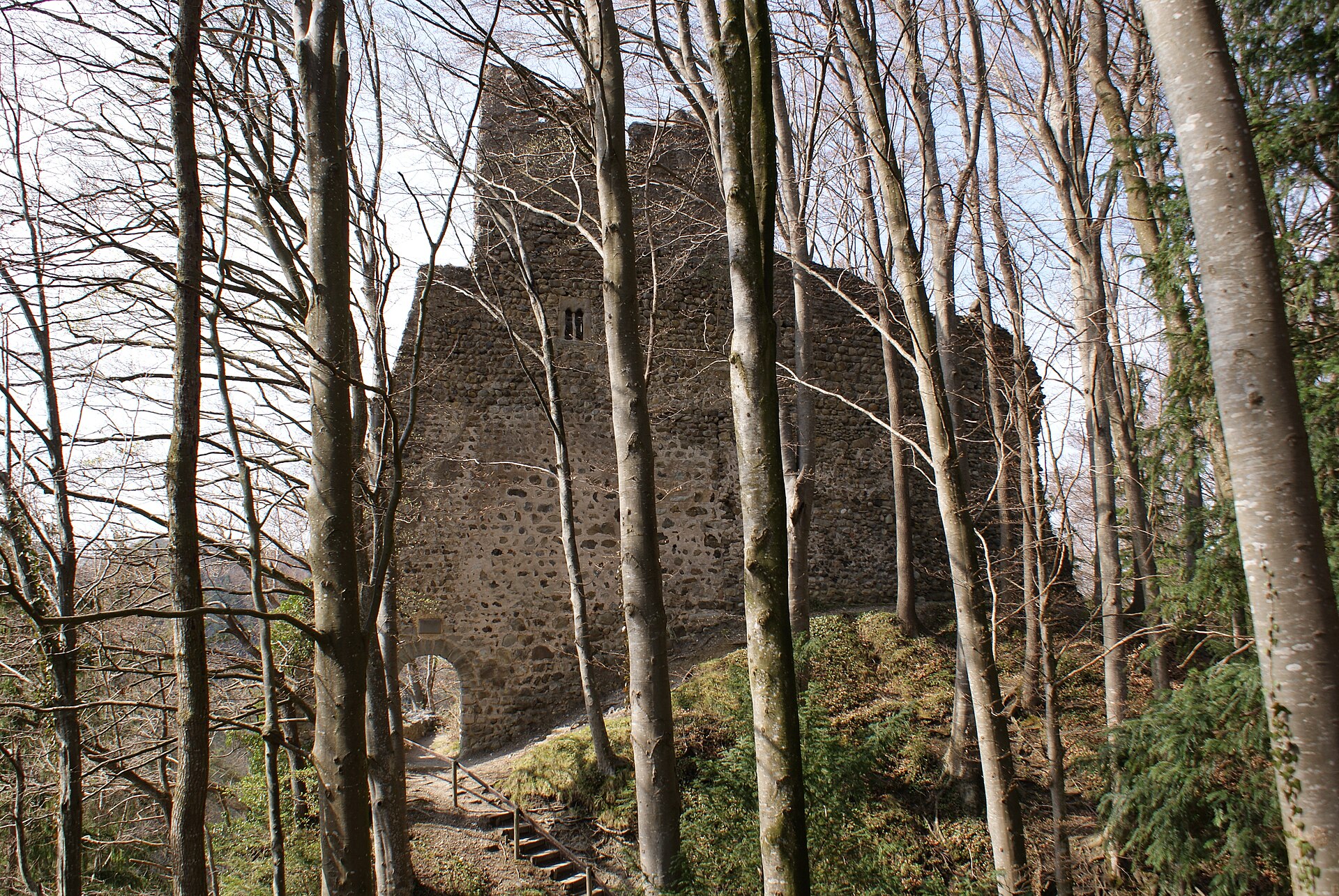
Alt-Ramschwag castle ruin is what remains of a medieval stronghold in the municipality of Häggenschwil, in the Swiss canton of St. Gallen. It stands on a rocky spur above the Sitter River, in the rolling countryside of eastern Switzerland, not far from Lake Constance. What is Alt-Ramschwag? The word "Alt" (old) sets this site apart from the nearby Neu-Ramschwag castle. Both strongholds belonged to the lords of Ramschwag, who served as ministerials of the Abbot of St. Gallen, a knightly class tied to the powerful abbey. Walls and fragments of the buildings still stand, making it an atmospheric goal for a short outing. How was the castle built? The castle was built by 1176 at the latest as the seat of the Ramschwag family, who developed the surrounding land. Some accounts place construction around 1200, so the exact starting date is given differently depending on who you ask. The steep spur above the Sitter offered natural protection and a view over the valley. Who owned it? Before 1370 the castle passed by marriage to Rudolf von Rosenberg-Zuckenriet. In 1427 the Helmsdorf family acquired it. Ownership kept changing while the stronghold gradually lost its importance. How did it become a ruin? In the late 15th century part of the castle fell into the Sitter. Around 1490 the southern section collapsed, and the remains were bought by a farmer, Hans Rudolf Koller. The timber parts were taken down before 1536, and for many years the ruin served locals as a quarry for building stone. Rescue in the 20th and 21st centuries In 1929 the architect Emil Müller and the builder Josef Thaler bought the ruin. Excavation and conservation took place between 1929 and 1932, and in 1932 the site was secured with the help of the Swiss Castle Association. The municipality of Häggenschwil bought the ruin in 2013. A renovation in 2022 was an unusual undertaking: because of the difficult terrain, around 60,000 kg of mortar from Graubünden was delivered in 210 helicopter flights. The work cost about 600,000 francs. Before you visit The ruin sits in wooded, rocky terrain, so sturdy shoes are a good idea. It suits a short walk combined with a bit of regional history. An information board from the cantonal archaeology service stands on site. Do not confuse it with Ramschwag castle near Nenzing in Austria's Vorarlberg, which is a separate building. Frequently asked questions Where is Alt-Ramschwag? In the municipality of Häggenschwil, canton St. Gallen, on a rise above the Sitter River. Who built the castle? The lords of Ramschwag, ministerials of the Abbot of St. Gallen. The castle existed by 1176 at the latest. Why is it a ruin? Part of it collapsed in the late 15th century, and the stone was later carried off for other buildings. Has the ruin been secured? Yes. Conservation was carried out in 1929-1932 and a major renovation in 2022. The municipality has owned it since 2013. Is it the same castle as Ramschwag in Austria? No. The Austrian Ramschwag near Nenzing is a different building, once called Welsch-Ramschwag to tell it apart from the Swiss castles Alt- and Neu-Ramschwag. Alt-Ramschwag is a good stop for anyone who enjoys medieval history, short trails and quiet corners of the Swiss countryside away from the busiest sights.
-
Neu-Thierstein Castle
Büsserach
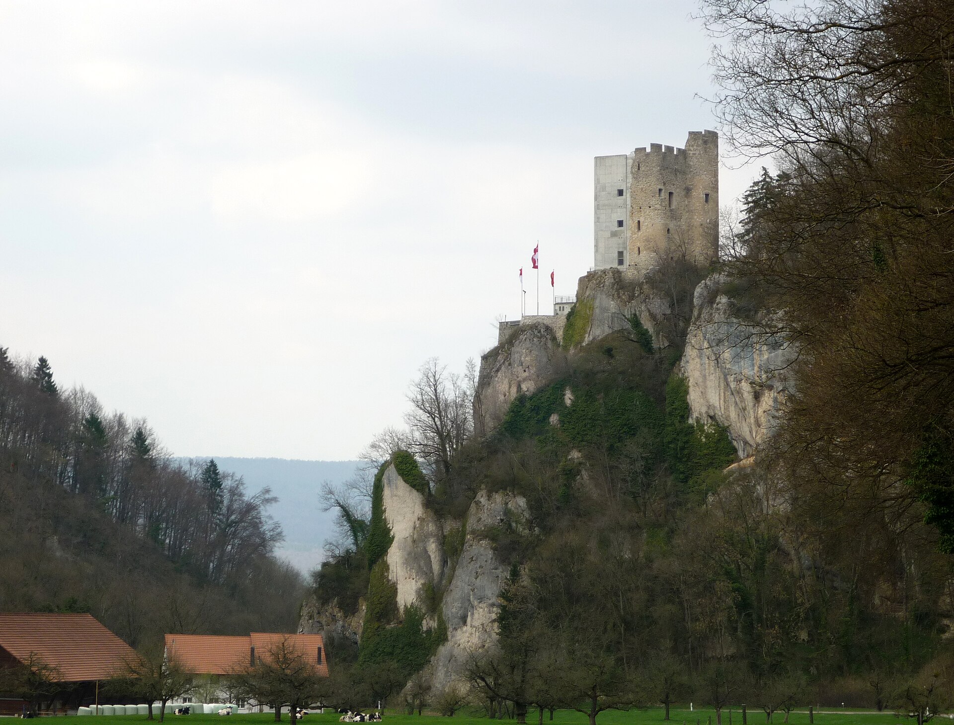
Neu-Thierstein Castle is a medieval castle ruin in the Swiss municipality of Büsserach, in the canton of Solothurn. Also known as Schloss Thierstein, it is regarded as a symbolic landmark of the Lüsseltal valley and the Schwarzbubenland region. It is one of the most recognisable sights in this corner of north-western Switzerland, and a rewarding destination for a quiet outing away from the country's busiest tourist routes. Where is Neu-Thierstein Castle? The ruin stands above the village of Büsserach in the canton of Solothurn. The surrounding area is the hilly Lüsseltal valley, where local roads have linked nearby settlements and the monastery of Beinwil for centuries. The site lies at roughly 47.385 N, 7.538 E. The Schwarzbubenland region is rural in character, and the castle dominates the valley landscape. How and why was the castle built? According to the available sources, the castle was founded around 1100. It is usually linked to the Saugern-Pfeffingen family, who are thought to have built it as the seat of the advocacy (Kastvogtei) over Beinwil monastery. The fortress therefore served an administrative and political purpose as well as a defensive one, allowing its holders to oversee church property and the surrounding countryside. A new section was added around 1294/95, which explains the "Neu" (new) in today's name. The castle's original name, Bello, is documented in 1321, while the name Thierstein appears in records in 1400. The Counts of Thierstein also feature in the castle's story and gave the fortress its later name. The Solothurn era In the 15th century the castle repeatedly came under the control of the city of Solothurn, which occupied it in 1445, 1467 and 1499. After the Thierstein counts died out in 1522, Solothurn took the castle permanently. It became the administrative centre of the secular bailiwick (Vogtei) of Thierstein. A Solothurn Landvogt, the official governing the district on behalf of the city, resided here until 1798. From demolition auction to romantic ruin In 1798 the castle was put up for auction with demolition in mind. It was not pulled down, however. In the 19th century private individuals who valued it as a romantic ruin saved it from destruction, which is why its surviving core can still be seen today. What can you see on site? The principal surviving element is the residential tower. Traces of an outer bailey, the outer part of the fortifications, are also visible. In 1997 the municipality of Büsserach took over the ruin to make restoration possible. That same year part of the tower collapsed, and its south-west corner was later rebuilt. A glass roof was added as weather protection, improving the building-physics conditions of the masonry and shielding it from moisture. Frequently asked questions Is Neu-Thierstein a ruin? Yes. It is a castle ruin whose main surviving element is the residential tower. Which country and canton is it in? Switzerland, in the canton of Solothurn, in the municipality of Büsserach. When was it built? It was founded around 1100, with a new section added around 1294/95. Who owns it today? The municipality of Büsserach took over the ruin in 1997 to enable restoration. Sources also mention a later change of ownership without naming the new owner, so check current access arrangements before visiting. Is the castle connected to a monastery? Yes. It was built as the seat of the advocacy over the nearby Beinwil monastery. Why is it called Neu-Thierstein? "Neu" refers to the new section added in the late 13th century, and "Thierstein" to the counts associated with the fortress; the name is documented from 1400.
-

Wynegg Castle
Malans
Wynegg Castle is a ruined hill castle above the village of Malans in the Swiss canton of Graubünden. Tourism sources also list it as Klingenhorn Wynegg, and it lies in the Heidiland region. What is Wynegg Castle? It is the remains of a fortress built around 1200 on a hill above Malans. Today it is a ruin rather than a fully equipped visitor attraction, so it suits a short outing with a view over the surroundings and a dose of local history. Who built it and who owned it? The castle is linked to the Wynegg family. The first known member, Ludwig von Wynegg, appears in a record from 1254, and the family's last mention dates from 1270. Whether they served the Bishop of Chur or the Barons of Vaz is not settled by the sources. After the family died out, the Vaz barons and the Bishop of Chur both claimed the castle. Ownership remained unclear even after the last of the Vaz line died around 1337–1338. In 1338 it was granted as a bishopric fief to the Counts of Toggenburg, and in 1436, after the last Toggenburg count died, it returned to the bishop. From abandonment to rebuilding According to the Historical Dictionary of Switzerland, the castle was abandoned toward the end of the 15th century and was already described as a ruin in 1548. Around 1600, Andreas von Salis had a new building erected on the site. Through marriage the estate passed to the Guler family of Davos, who expanded Wynegg and around 1624 styled themselves Guler von Wyneck. The site was finally abandoned in the late 18th century and left to decay. What can you see today? Little of the original 13th-century fabric survives. The Historical Dictionary of Switzerland says only a few remains of the three-storey residential block and the outer wall are original, and most of the masonry dates from the 17th century. Tourism descriptions mention a tower preserved to three storeys, with traces of plaster and beam holes still visible. The upper part is in poor condition and overgrown, so take care and avoid unstable sections. Frequently asked questions Where is Wynegg Castle? Above Malans in the canton of Graubünden, Switzerland, at roughly 46.9944 N, 9.57 E. Is it a castle or a ruin? A ruin. The castle was abandoned in the late 15th century, partly rebuilt later, and then left to decay again after its final abandonment in the 18th century. How old are the surviving walls? Most of the visible masonry dates from the 17th century; only a few fragments come from the 13th-century building. Who owned the castle? First the Wynegg family, then it was disputed between the Vaz barons and the Bishop of Chur. From 1338 it was a fief of the Counts of Toggenburg, from 1436 it was back with the bishop, and later the von Salis and Guler families were tied to it. Is it safe to visit? The upper parts of the tower are in poor condition, so it is best to view the ruin from outside and keep away from weakened walls. Who is it for? Anyone interested in Graubünden's local history, medieval ruins and quiet walks around Malans. It combines well with other stops in the Heidiland region, and the story of the castle, from feudal disputes to its 17th-century rebuilding, gives a short visit real context.
-
Rosenberg Castle Ruins
Herisau
Rosenberg Castle Ruins (Burgruine Rosenberg) are the remains of a medieval hill castle in the municipality of Herisau, in the Swiss canton of Appenzell Ausserrhoden. The ruins stand on a wooded hill above the hamlet of Burghalden and make a rewarding short outing for history lovers and hikers in eastern Switzerland. What are the Rosenberg Castle ruins? They are what is left of a castle built on a hilltop in the 12th or around the turn of the 13th century. Sources disagree on the exact date: some say about 1150, others about 1200. The castle is described as a clearing castle, founded on land cleared of forest, with a palace-like residential tower. Today only ruins remain, hidden among the trees. Who built the castle? The builders were the lords of Rorschach, a noble family in the service of the Abbey of St. Gall. According to one account, the first owner, Egolf von Rorschach, took the name von Rosenberg once the castle was finished. The family raised two strongholds near Herisau: Rosenberg and the nearby Rosenburg, roughly 2.3 km (1.4 mi) apart. The two are easy to confuse, so check which one you are looking at when planning a visit. What is the castle's history? Rosenberg was tied to the Abbot of St. Gall. In 1271, Abbot Berchtold von Falkenstein and about 70 of his knights reportedly celebrated Christmas here, which shows the castle's importance to the church authorities of the day. The end came with the Appenzell Wars. Herisau broke away from the abbey and sided with the Appenzell rebels. During the fighting in 1403, strongholds on Herisau territory were destroyed, including Rosenberg and Rosenburg. Rosenberg was among the first targets of the rebels, and it was never rebuilt. How do you reach the ruins? The site is freely accessible. Paths lead uphill from Herisau railway station and from the hamlet of Rüti. The terrain is wooded and hilly, so sturdy shoes help. Mostly wall fragments survive, so think of it as a woodland walk with a historical highlight rather than a developed attraction. Frequently asked questions Where are the Rosenberg Castle ruins? In the municipality of Herisau, canton of Appenzell Ausserrhoden, above the hamlet of Burghalden (about 47.396 N, 9.282 E). Is there an entrance fee? No, the ruins are freely accessible. When was the castle destroyed? In 1403, during the Appenzell Wars. Is Rosenberg the same as Rosenburg? No. Rosenburg is a separate castle built by the same family, about 2 km west of Herisau. Who owned the castle? The lords of Rorschach, servants of the Abbey of St. Gall.
-
Montebello Castle
Bellinzona
Montebello Castle is one of the three medieval castles of Bellinzona, the capital of the Swiss canton of Ticino. Together with Castelgrande and Sasso Corbaro it forms a fortified complex that has been a UNESCO World Heritage Site since 2000. Today it houses an archaeological museum, and its walls offer views over the town and the valley around it. Where is Montebello, and how does it compare with the other castles? Bellinzona sits in the Alpine foothills, and its defences consist of walls and three fortresses. Castelgrande crowns a rocky hill above the valley, with walls that shelter the old town and link up with Montebello. Sasso Corbaro, the highest of the three, stands on an isolated rocky promontory to the south-east of the others. Montebello is the second-largest castle of the group and serves as the middle link in this defensive chain. What is the history of Montebello Castle? The castle was built in the late 13th century as the residence of the Rusca family of Como. In 1335 the Visconti of Milan took it over and enlarged it, giving it a chiefly military purpose. With Castelgrande it formed a defensive ring around the medieval town, controlling passage through the valley. That strategic layout made Bellinzona a key stop on the Alpine routes for centuries. What can you see inside? An archaeological exhibition occupies the castle. It tells the story of the medieval fortification, its restoration, and notable moments in local history. A newer display, called Archeologia Montebello, presents more than 200 finds from Ticino, running from the Mesolithic period to the end of Roman times. A visitor guide in four languages can be downloaded to your smartphone. How do you get there, and what else is worth knowing? You can walk up from Piazza Collegiata, drive, ride the "Artù" tourist train, or use public transport. Outside the castle there is a well-equipped children's playground and a photo spot on the Grand Tour of Switzerland. Visitors can also try making Salame dei Castelli di Bellinzona, a traditional smoked sausage. The castles can be visited individually or with the Fortezza Pass, which covers the three castles, the walls, the Castelgrande museum, the Archeologia Montebello route and temporary exhibitions. Frequently asked questions Is Montebello part of the UNESCO listing? Yes. The three castles, the defensive wall and the ramparts of the town of Bellinzona were inscribed in 2000. Who built the castle? The Rusca family of Como, at the end of the 13th century. The Visconti of Milan took it over in 1335. What is the main attraction? The archaeological exhibition with over 200 finds from Ticino, plus the medieval fortress itself with its views over the town. Is it a good stop with children? Yes, there is a playground by the castle, and you can try a local culinary tradition nearby. Should I check opening hours? Yes. Hours and prices change with the season, so check the official site, fortezzabellinzona.ch, before your visit. Montebello is best combined with Castelgrande and Sasso Corbaro. Only all three together show how the old defensive system worked for a town guarding the Alpine passes. Walking between them takes time, so plan at least half a day and wear comfortable shoes, since the route climbs and runs over stone surfaces.
-
Sasso Corbaro Castle
Bellinzona
Sasso Corbaro Castle is the highest of the three castles of Bellinzona, the capital of the Swiss canton of Ticino. It stands on an isolated rocky promontory south-east of the other two fortresses, and for centuries it has watched over the valley at the foot of the Alps. Where is Sasso Corbaro and what is it part of? Bellinzona sits in the Alpine foothills, and its defences consist of fortified walls and three castles: Castelgrande, Montebello and Sasso Corbaro. Castelgrande crowns a rocky hill above the valley, while the walls protect the old town and link it to Montebello. Sasso Corbaro stands apart and higher up, on a hill of its own. Since 2000 the castles and the town's walls have been a UNESCO World Heritage Site. Who built it, and why? The fortress is dated to 1479, and it is the only one of the three castles with such a precise date. The Dukes of Milan ordered it to answer the increasingly bold raids of the Swiss Confederates into the countryside around Bellinzona. The Sforza court architect Benedetto Ferrini designed it, and construction took just over six months. The goal was to close a gap in the defences through which an enemy could push toward Milan. A tower had in fact stood on the site earlier and became the core of the later castle, so 1479 is best read as the moment the fortress was completed. What was the castle called in the past? During the period of Swiss rule it was known as Unterwalden Castle. In 1818 it was renamed Santa Barbara Castle, a name you may still come across. Was Sasso Corbaro ever a prison? Besides its defensive role, the castle held prisoners. An escape from its walls in 1494 is documented. What did the restoration change? Between 2004 and 2006 the castle underwent a thorough restoration led by architect Paola Piffaretti. It allowed the building to take on new roles today. What can you see here today? Sasso Corbaro has no permanent history exhibition. Instead it hosts temporary exhibitions and conference rooms, and civil weddings are held within its walls. The historical and archaeological museum is in Castelgrande, and Montebello hosts an archaeology exhibition. If you plan to visit all three fortresses, consider the Fortezza Pass, which covers the three castles and the Castelgrande museum. When can you visit? The 2026 season runs from 28 March to 8 November, daily from 10:00 to 18:00. Check the official regional tourism pages before you go, as opening details can change. Why go? The elevated position gives wide views over Bellinzona and the surrounding hills. It is also a good place to understand how the town's defences worked: three fortresses and walls controlled the route through the Alps. Sasso Corbaro is quieter than Castelgrande, which makes it pleasant for a longer walk along the walls and for photos. Frequently asked questions When was Sasso Corbaro built? It was completed in 1479 on the orders of the Dukes of Milan, in just over six months. Is it the highest castle in Bellinzona? Yes, it stands higher than Castelgrande and Montebello. Is there a museum inside? There is no permanent museum, only temporary exhibitions. The historical and archaeological museum is in Castelgrande. Is it a UNESCO site? Yes, together with the other castles and the walls of Bellinzona since 2000. Can you get married here? Yes, civil weddings are held at the castle. What was it called earlier? Unterwalden Castle, and from 1818 Santa Barbara Castle.
-
Gutenfels Ruins
Bubendorf
Gutenfels Ruins are the conserved remains of a small medieval castle perched on a steep rock above the Fluebach valley, in the municipality of Bubendorf, canton of Basel-Landschaft, Switzerland. The site is quiet and little known, sometimes described as the often forgotten little sister of nearby Wildenstein Castle. Where are the Gutenfels Ruins? The ruins stand on a rock block that drops steeply on every side, above the Fluebach valley close to Bubendorf. The coordinates are roughly 47.4227 N, 7.7267 E. The area lies in the Basel Jura, near Wildenstein Castle, so the two sites combine easily into a single outing. What is the history of the castle? The castle was founded around 1230 by the lords of Eptingen, although it was held as a fief of the counts of Frohburg. In 1326 it passed to the lords of Ramstein and was abandoned soon afterwards. Little is recorded about what happened later, so today the place is valued mainly as a landscape and heritage site rather than as a residence with a richly documented past. Specialists classify Gutenfels as a small "Rodungsburg", a clearing castle linked to the medieval clearing of forest and settling of new land. Fortresses of this type helped a noble family watch over its surroundings and strengthen its position. What can you see on site? The castle consisted of two parts: a large residential tower on the highest point of the rock, a walled courtyard on a somewhat lower terrace. The ruins have been conserved, which protects the surviving masonry from further decay. Visitor guides call the place wild, and it owes its protection from overgrowth to private individuals. Expect a natural, unpolished setting rather than a major attraction with extensive facilities. Who is it for? Gutenfels suits castle fans, medieval history enthusiasts and anyone after a peaceful walk. The rocky scenery and valley setting make it a pleasant short trip for photographing ruins. Because the terrain is steep, wear sturdy footwear and take care near the edges of the rock. Frequently asked questions When was Gutenfels built? Around 1230, by the lords of Eptingen. Who owned the castle? The Eptingen family as vassals of the counts of Frohburg; in 1326 it passed to the lords of Ramstein. Is the castle inhabited? No. It was abandoned soon after 1326 and is now a conserved ruin. Is it the same as Gutenfels in Kaub? No. The German castle of that name on the Rhine is an entirely different building. What is nearby? The best-known neighbour is Wildenstein Castle, owned by the canton of Basel-Landschaft since 1994. Is there an entrance fee? No information on fees was found; check current conditions before you travel.
-
Burgau, Medieval Castle Site
Flawil
Burgau, Medieval Castle Site is an archaeological site in the hamlet of Burgau, part of the municipality of Flawil in the canton of St. Gallen, eastern Switzerland. The fortress itself is not a ruin you can tour in the usual sense, but the place is rewarding for anyone curious about the region's medieval past. What is this place? The canton of St. Gallen's inventory of archaeological sites lists a castle at Burgau, first mentioned around the end of the 10th century. It was destroyed in 1403. The canton treats castles and castle sites as worth protecting because they document medieval social, political and economic history. Who held it? According to the inventory, Burgau may have been the original seat of the Giel family. In the 15th century the court of Flawil was a fief of the Giel von Glattburg family, and in 1486 the Abbey of St. Gallen bought it back. The castle therefore belongs to a chain of power shifts in an area where the abbey played a leading role. How old is the settlement? The hamlet of Burgau is documented from 964 under the name Purchouva. The name points to the word "Burg", a fortified place, which fits the site's history. What else is worth knowing about Burgau? Burgau formed its own court, together with Mülleregg. A medieval law book survives, the Burgau Offnung of 1469. It governed relations among members of the courts and communal landholdings in the lower court of Burgau, under the lord's reeve. The hamlet has an old town hall dating from 1639, considered one of the oldest half-timbered houses in the canton. Who is it for? History and archaeology fans who like to combine local traces of the Middle Ages with a short walk through a village. Do not expect tourist facilities or dramatic walls. The site lies at 47.3999625 N, 9.2168914 E, and Flawil is not far from the city of St. Gallen. Frequently asked questions Do any castle walls survive at Burgau? The available sources do not describe visible remains; the site is classified as a castle site. When was the castle destroyed? In 1403. When was it first mentioned? Around the end of the 10th century. Is there anything else worth seeing nearby? Yes, the old town hall of 1639, a historic half-timbered building in Burgau itself. Which canton is Burgau in? St. Gallen, in the municipality of Flawil.
-
Burg Strahlegg
Fideris
Burg Strahlegg is a medieval castle in the hamlet of Strahlegg, part of the municipality of Fideris in the Prättigau valley, canton of Graubünden. Today it is a historic monument, a sculptor's workshop and a small gallery in one, and visitors can see it on a guided tour. Where is Burg Strahlegg? The hamlet of Strahlegg sits on a terrace above the valley. The Arieschbach gorge separates it from the village of Fideris. The castle stands beside the old valley road that ran from Fideris to Küblis, one of the historic routes through the Prättigau. The area is good for walking, and the region promotes marked footpaths, including a route linking Fideris with Strahlegg. What is the history of the castle? According to the Historical Lexicon of Switzerland (HLS), the castle dates from the first half of the 13th century. In the 14th century it belonged to the Streiff family. From 1403 the Counts of Toggenburg, a powerful feudal house in medieval Graubünden, took it over. It was abandoned during the 15th century. Sovereign rights over it lay with the lordship of Castels, which is why the two sites are often discussed together. Sources differ on what 1403 marks: the regional tourism site treats it as the first documented mention, while the HLS treats it as the moment the Toggenburg counts acquired the castle. Around 1802 the castle was depicted, together with Castels, in an engraving by Johann Balthasar Bullinger and Heinrich Füssli. A copy is held by the Swiss national archives. What can I see today? The present owner, Marco Walli, is a carver and wood sculptor. He bought the castle about fifty years ago, and the restoration took eight years. The tower now has a roof, stairs and floors, so it can be entered. Inside, it serves as an exhibition space for the owner's carved works. Can I visit the castle? Castle and studio tours are offered to interested individuals and groups. The available sources give no opening hours, prices or booking rules. Before you go, contact the owner or check the Prättigau tourism website. The postal address is 7235 Fideris. Frequently asked questions Is Burg Strahlegg a ruin? No. The tower has been restored and has a roof, stairs and floors. What century is the castle from? The first half of the 13th century. Who owns it? A private owner, the sculptor Marco Walli, who shows his own work inside. Is it the same as Strahlegg near Amden? No. A different site with the same name exists in the canton of St. Gallen and is unrelated to the castle in Fideris. How is it connected to Castels castle? Sovereign rights over Strahlegg lay with the lordship of Castels, so the two are often presented together.
-
Grünenberg castle ruin
Melchnau
Grünenberg Castle Ruin, Melchnau Grünenberg castle ruin stands on the Schlossberg hill above Melchnau in the canton of Bern, Switzerland. Once the seat of a powerful noble family, it was destroyed during medieval conflicts with the city of Bern and is now a site open to visitors, looked after by a local foundation. How did Grünenberg Castle begin? The stronghold probably dates back to the 10th or 11th century, when a timber-and-earth fortification occupied the hill. Around 1200 it was rebuilt in stone. The Lords of Langenstein are first mentioned in 1194, when they took part in founding St. Urban's Abbey. Soon afterwards the Barons of Grünenberg inherited their lands and governed them from this castle. The origin of the family itself is unclear; it is linked to the Radolfzell area, though this is not proven. What happened to the castle? Its fate was tied to the rise of the city of Bern. In 1383, during the Burgdorf War, Bern destroyed the castle, and in 1444 it took the site for good. For a few more years it served as a bailiff's seat before being abandoned. Some sources place its final end around 1530, after a fire, followed by demolition. What can you see today? The curtain wall, the remains of the keep and two residential wings survive. The most important part of the complex is the castle chapel, dedicated to St. George. Its floor of tiles from St. Urban Abbey is exceptionally well preserved. The chapel's patronage rights passed to Bern in 1480. The ruin is secured and open to the public, maintained by the Stiftung Burgruine Grünenberg Melchnau foundation. The Bern archaeological service has also published a book on noble life on the Melchnau Schlossberg, a sign that the site continues to attract research. Who is this place for? Fans of medieval castles and Swiss history who want a site away from the main tourist routes. Walkers who enjoy a short climb to a hilltop with views over the Bern countryside. Photographers drawn to atmospheric walls and tower remains. Families with children, for whom a ruin is a natural playground for young explorers. Frequently asked questions Where is Grünenberg ruin? On the Schlossberg hill above Melchnau, in the canton of Bern, Switzerland. Who destroyed the castle? The city of Bern destroyed it in 1383 and took it permanently in 1444. What is the most important part of the ruin? The chapel of St. George, with a well-preserved floor of tiles from St. Urban Abbey. Is the ruin open to visitors? Yes, the site is open to the public and cared for by a local foundation. Who owns the site? The Stiftung Burgruine Grünenberg Melchnau, which maintains the walls and keeps the site accessible. Grünenberg is a good stop for anyone who wants to see what a medieval noble residence looked like in the heart of the canton of Bern. The surviving walls, the chapel and the well-documented history give a clear picture of the shifting balance of power between noble families and the growing city of Bern. It suits a quiet outing that combines a walk in the surrounding countryside with a lesson in regional history, after which it is easy to return to Melchnau and continue exploring.
-
Schwarzenbach Castle
Schwarzenbach SG
Schwarzenbach Castle (Schloss Schwarzenbach) stands in the village of Schwarzenbach, part of the municipality of Jonschwil in the Swiss canton of St. Gallen. A former knightly seat and administrative centre, it traces its story back to the Middle Ages and the contest for influence between the Abbey of St. Gallen and the Habsburgs. Where is Schwarzenbach Castle? The castle lies in eastern Switzerland, in the canton of St. Gallen, in the village of Schwarzenbach within Jonschwil. Its coordinates are roughly 47.4426° N, 9.0693° E. The town of Wil, with which the castle shares much of its history, is close by. How did the castle begin? The settlement of Schwarzenbach appears in records as early as 779, in a donation document in favour of the Abbey of St. Gallen. Around 1200, the abbey's ministerials, knights bound to its service, raised a small fortified tower on a hill above the old mill. The family took the name Lords of Schwarzenbach. Local accounts suggest the building may be older still, pointing to features such as a wooden beamed ceiling in the knights' hall. The Habsburgs and the dispute with the abbey When the family died out, Ulrich von Leuberg inherited the lordship and sold it in 1273 to Count Rudolf of Habsburg, who became King of the Germans that same year. Rudolf had a small town founded opposite Wil, which provoked conflict with the abbey. The peace of 1301 required the town and its walls to be torn down, but the castle was allowed to stand. Sources disagree on when the town was founded: some say 1273, others place it after 1282. A succession of owners The castle changed hands several times, belonging among others to the Counts of Toggenburg and the Lords of Hewen. In 1483 the Abbey of St. Gallen bought it, and it became the seat of a bailiff (Obervogt) who administered the surrounding lands. From the abbey's end to today After the abbey was dissolved in 1805, the castle became state property and served as a district administrative seat before passing into private ownership. Swiss military training camps were held here in 1824 and 1836. Later owners included a Zurich proprietor, and from 1943 to 1959 a charitable institution. Since 2001 it has had several private owners. Frequently asked questions Where is Schwarzenbach Castle? In the village of Schwarzenbach, in the municipality of Jonschwil, canton of St. Gallen, Switzerland. When was it built? A fortified tower was erected around 1200, though some researchers think parts of the building could be older. Can I visit the castle? It is privately owned, so check beforehand whether and when access is possible. It can be admired from outside as part of the village landscape. Who were its most important owners? The Lords of Schwarzenbach, the Habsburgs, the Counts of Toggenburg, the Lords of Hewen and, from 1483, the Abbey of St. Gallen. Why does it matter historically? Its story illustrates the late 13th-century rivalry between the Habsburgs and the Abbey of St. Gallen for control of the region, and the later rule of the abbey through a bailiff.
-
Trachselwald Castle
Trachselwald Castle is a medieval fortress in the municipality of Trachselwald, in the Swiss canton of Bern, in the heart of the Emmental valley. It is listed as a Swiss heritage site of national significance, and its story is closely tied to the religious and social conflicts of early modern Switzerland. Why visit Trachselwald Castle? Few places show the history of this region as vividly. For centuries the castle served as a seat of Bernese authority in the area and later as a prison. Today it draws visitors interested in the Reformation era, the Anabaptist movement and the peasant uprisings, and it sits in quiet, green, hilly Emmental countryside that rewards a slow visit. What is the history of the castle? The fortress first belonged to noble families before passing under the control of the city of Bern. Bern turned it into a regional administrative centre, from which surrounding villages were governed and justice was administered. That role later extended to holding prisoners. The tower held mostly Anabaptists, members of a religious movement persecuted by the Bernese authorities from the 16th into the early 18th century. Cramped cells and iron restraints still bolted to the walls leave a strong impression. In 1653, during the Swiss Peasant War, the castle held the rebel leader Niklaus Leuenberger before he was executed in Bern. Hans Haslibacher, an Anabaptist, is also associated with the castle and remains part of local memory. What can you see on site? The prison tower, with its cells and surviving restraints. The courtyard and castle rooms, which are gradually being turned into museum space about the history of the Mennonites and Anabaptists. The exhibition "Paths to Freedom", telling the story of persecuted communities. Visitors praise the displays and the audio guides. Views over the Emmental from the castle surroundings. Practical information The climb up the tower is steep and the stairs have no handrails, so take care and wear sturdy shoes. Because exhibition work is ongoing, some rooms may be temporarily closed. Check opening hours and entry rules before you go, as they change as the museum develops. Frequently asked questions Where is Trachselwald Castle? In the municipality of Trachselwald, canton of Bern, in Switzerland's Emmental region. Who was imprisoned in the castle? Mainly Anabaptists, and in 1653 also Niklaus Leuenberger, leader of the peasant uprising. Is the castle a protected monument? Yes. It is on the Swiss inventory of heritage sites of national significance. Is there a museum? Yes. An exhibition on the Anabaptists is open, and further rooms are being prepared as museum space on Mennonite history. Is the tower climb safe for children? The stairs are steep and have no railings, so take extra care with young children. Who is this visit for? We recommend the castle to fans of Swiss history, anyone interested in the story of religious freedom, and travellers exploring the Emmental by car or on foot. A visit usually takes one to two hours, depending on how long you spend with the exhibition and the tower. It combines well with a short walk in the surrounding hills and a taste of the regional cheeses the valley is famous for.
-
Moutier château
Moutier
Moutier Château (Château de Moutier) is a baroque building in the centre of Moutier, in the Swiss Jura. It is the former residence of the provosts and now houses the prefecture. It stands at 47.28035 N, 7.37307 E, in the heart of the old town. What is the château in Moutier? Despite the name, it is not a fortress with towers and a moat. The château prévôtal, or provost's château, was the administrative seat tied to the monastic chapter. Moutier grew around the Moutier-Grandval abbey, founded around 640, and the official residence reflected that institution's standing in the region. What is its history? According to the Historical Dictionary of Switzerland, the provost's château dates from the late 16th century. The Swiss castles website swisscastles.ch, citing the researcher Auguste Quiquerez, gives 1590 as the presumed date of the first building. The same site describes a fire in 1610 that nearly destroyed it, and a second one in February 1737 that reduced it to ashes. The chapter ordered a rebuild. According to that source it cost 15,000 Basel pounds, and the present baroque building was finished in 1740. The look you see from the street today therefore dates from the mid-18th century. What happened after the French Revolution? During the French Revolution, in 1798, the château was sold as national property. In 1817 the canton of Bern bought it back, paying 1,000 louis d'or according to swisscastles.ch, and turned it into the prefecture. The building was renovated in 1932. A judicial reform in 1997 reshuffled the courts inside it. Why is Moutier in the news? For decades the town was at the centre of the so-called Jura question. In 2021 residents voted to move from the canton of Bern to the canton of Jura, and the change took effect on 1 January 2026. The former provost's château thus became a state building of the new canton, adding to its significance as a witness to local history. Can you visit? The building serves administrative functions, so it is not a conventional museum. It is best admired from outside during a walk through central Moutier. Pair the stop with the story of the Moutier-Grandval abbey and the surrounding Jura valleys, popular with hikers and cyclists. Frequently asked questions Where is Moutier Château? In the town of Moutier, in the Swiss Jura, in the town centre. When was the current building completed? The baroque structure was finished in 1740, after the fire of 1737. What is it used for today? It houses the Moutier prefecture. Is it a defensive castle? No, it is a former administrative residence of the provosts rather than a fortress. When did Moutier join the canton of Jura? The change took effect on 1 January 2026, following the 2021 vote. Is there an entrance fee? It is a working government office, not a ticketed attraction. Visitors view it from the outside.
-
Schloss Interlaken
Interlaken
Schloss Interlaken is a castle in the heart of the town of Interlaken in the Bernese Oberland, built on the foundations of a medieval Augustinian monastery. Today it houses the district administration, yet its historic walls, cloister and castle church make it a worthwhile stop on a walk through town. How did the monastery begin? Written records point to 1133, when Emperor Lothair III placed the abbey under his protection. According to tradition, the founder was Baron Seliger von Oberhofen, who established a community of Augustinian canons around 1130. The monastery received the Latin name "Inter lacus", meaning "between the lakes", because it stands on the strip of land between Lake Thun and Lake Brienz. The name of the whole town derives from it. Before that, the settlement beside the monastery was known as Aarmühle. A double monastery with real power Interlaken was a double monastery, with nuns living alongside monks. One source puts the 14th-century community at around 300 nuns and 40 monks. The abbey became the largest landowner in the Bernese Oberland and shaped life across the region. The presence of the nuns is also linked to one explanation of the name of the Jungfrau, the "maiden" mountain. Reformation and the castle The monastery ended with the Reformation. The canton of Bern took over its property in the first half of the 16th century (sources give different dates, from about 1525 to 1528). The complex became the seat of Bern's governor and gained the name Schloss, or castle. In later years it served varied purposes, including as a warehouse and a hospital. The former monastery church became the castle church (Schlosskirche). What to see Gothic cloister – a surviving gallery around the inner courtyard. Chapel from 1452 – one of the older parts of the complex. Church tower – dating from the early 14th century, one of the few medieval traces in the church building. Courtyard and garden – a calm corner of the town, away from the bustle of the main streets. The interior serves administrative functions, so visitors mainly see the outer parts and the church. It is worth checking current access times with the local tourist office. Frequently asked questions Is Schloss Interlaken a castle in the classic sense? Not quite. It is a former monastery that became a seat of authority after the Reformation, hence the name Schloss. Where does the name Interlaken come from? From the Latin "inter lacus", "between the lakes", the name given to the monastery located between Lake Thun and Lake Brienz. Can I go inside? The building is still used by the administration, so access to the interiors is limited. The cloister, courtyard and castle church are the easiest parts to see. How long does a visit take? Usually 30 to 60 minutes, especially if you combine it with a stroll through central Interlaken. Where is it? In the town centre, close to the Aare river and the main streets, an easy walk from Interlaken West station.
-
Splügen Castle
Rheinwald
Splügen Castle is a ruined medieval fortress in the Swiss canton of Graubünden, set in the Rheinwald forest about a kilometre east of the village of Splügen. It is the only castle in the whole valley, and the walk up from the village takes roughly ten minutes. Where is Splügen Castle? The ruins stand on a small hill in the eastern part of the Rheinwald valley, surrounded by woodland. The position was chosen with purpose: below it ran the old valley road that led from the Via Mala gorge over the Splügen and San Bernardino passes. From the hill, the castle's occupants could watch traffic on one of the important Alpine trade routes between north and south. When was the castle built? Sources disagree. Some list the castle as built around 1275. More recent research, cited by Komoot, points to about 1340 and the Counts of Werdenberg-Sargans as its builders. The gap shows how thin the documentary record for this site is. What remains of the castle? The remains include a double-winged palas and a curtain wall. Three walls, each well over a metre thick, still stand, while the east wall facing the valley has collapsed. The layout can still be read: the lower storeys held cellars and storerooms, and the third floor contained the living quarters. What do we know about its history? Written records are sparse. In 1462, Jörg of Werdenberg paid the Amman (steward) of Rheinwald a rent for the estate by the castle, and the entry referred to the old castle of Splügen. Whether the building still stood at that point is unknown. When the Rheinwald was sold in 1493 to Gian Giacomo Trivulzio, the castle of Splügen was no longer mentioned. The castle that helped save a valley In the 1940s a dam was planned right at the castle ruins, 700 metres long and 150 metres high. The reservoir would have flooded part of the Rheinwald. The valley's residents successfully resisted the project, and the ruins and the landscape around them survived. How to visit The approach from Splügen village takes about ten minutes on foot. The ruins can be explored freely; this is a short outing rather than a full-day visit. It combines well with other routes in the Rheinwald, such as the Römerweg Rheinwald or the valley hike from Sufers to Hinterrhein. Frequently asked questions Is Splügen Castle the only castle in the Rheinwald valley? Yes, it is the only castle in this valley. How long does it take to reach the ruins? About ten minutes on foot from the village of Splügen. Who built the castle? According to more recent research, the Counts of Werdenberg-Sargans built it around 1340. Older sources give around 1275. What is left of the building? Parts of a double-winged palas and a curtain wall. Three walls survive; the east wall has collapsed. Why was the valley never flooded? A dam project from the 1940s was opposed by local residents and never went ahead. Where exactly is the castle? In the eastern part of the Rheinwald valley, in the forest, below the old road that ran from the Via Mala over the Splügen and San Bernardino passes.
-
Château d'Hermance
Hermance
Château d'Hermance is a medieval stronghold on Lake Geneva, of which a round tower and sections of the town's defensive walls still stand. It lies in Hermance, a small village in the canton of Geneva right next to the French border, a short drive from central Geneva. What remains of the castle at Hermance? The main survivor is the round tower, built in 1337–1338 for Humbert II, Dauphin of Viennois, under the master builder Mermet Jonzier. It was placed where the castle had the least natural protection, so it reinforced the most exposed stretch of the defences. Parts of the walls that once enclosed the fortified town also remain, and together with the tower they are the only visible traces of Hermance's medieval fortifications. The tower has been a listed historic monument since 1921. What is the castle's history? The first mention of the castle dates to 1247, in a bull of Pope Innocent IV. At that time the lords of Faucigny, who ruled the area, were establishing a fortified town on the lakeshore. Local accounts say Count Peter II enlarged the castle around 1260 to guard the western approach to the lake. Sources differ on some details of the earliest builders, but all point to the 13th century as the start of the fortress. During the 14th century the castle changed hands several times amid feudal wars between the region's powerful families. After 1355 Hermance was tied to the House of Savoy. Its military role ended after the Treaty of Saint-Julien in 1603, when the harbour was filled in and the defensive installations were dismantled. How did the tower survive? Once it lost its defensive purpose the structure slowly decayed. In the 1820s the Geneva philanthropist Henri-Louis Boissier bought the tower, which halted its ruin. Swiss press reported that conservation work began in 2023 and was expected to finish in 2025. We could not confirm whether the work is complete, so check the current situation before you visit. What else is nearby? The tower makes a natural starting point for a stroll through Hermance, often described as one of the best-preserved medieval villages on Lake Geneva. Narrow lanes, old houses and a lakeside promenade make for an easy visit that fits well into a day trip from Geneva. The tower itself is mainly something to admire from outside, set against the walls and the village buildings. Frequently asked questions When was the Hermance tower built? The round tower dates from 1337–1338 and was built for Humbert II, Dauphin of Viennois. Does the whole castle survive? No. Mainly the tower and part of the town walls remain. Is the site protected? Yes, the tower was classified as a historic monument in 1921. When did the castle lose its military importance? After the Treaty of Saint-Julien in 1603, when the harbour was filled in and the fortifications taken down. Can I reach it from Geneva? Yes, Hermance is about 20 minutes from Geneva on the lake's southern shore, near the French border. Has the restoration finished? Work started in 2023 and was planned to run until 2025. If access to the tower matters to you, check the Hermance municipality website before travelling. Why visit? It is a small but readable trace of medieval defence on Lake Geneva. The tower, walls and picturesque village together show how the border zone between Savoy and neighbouring lords once looked. For anyone interested in the history of the Geneva region, it is an easy and calm hour's stop.
Earn badges for the places you visit
Download NextOnTrip, discover new places and check off your trails.