Coast in Spain
A guide to 196 Coast in Spain — with descriptions, photos and traveler visits from the NextOnTrip community. Locations spread across 153 cities and towns. Most visited by the community: Far de Tossa, Espai Far, Parque de la Torre.
-
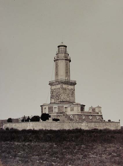
Far del Llobregat
Barcelona
Far del Llobregat is a 19th-century lighthouse standing at the historic mouth of the Llobregat River, right on the edge of the Port of Barcelona. Today it's surrounded by container terminals and industrial facilities in the Zona Franca district, but for over a century and a half it served as one of the most important navigational landmarks on the Catalan coast. When was the lighthouse first lit? The lighthouse was designed by engineer Simó Ferrer and its light was switched on for the first time on 1 March 1852. It was only the second lighthouse ever built in Spain, predating the Montjuïc lighthouse — built in 1906 specifically to take over its main navigational role for the port of Barcelona — by 54 years. What was the lighthouse built for? Far del Llobregat was built to serve two purposes at once. First, it acted as a landfall light, helping ships approaching from the open sea identify the port of Barcelona. Second, it warned mariners of the dangerous sandbanks at the mouth of the Llobregat delta, which for centuries posed a real hazard to merchant vessels sailing close to the coast. Thanks to the lighthouse's beam, ships could accurately locate the shallow waters and steer clear of running aground. Why is it also called an "aerolight"? One of the lesser-known facts about this lighthouse is that it doubled as an aerolight. The prisms in its glass dome reflected light upward as well as outward across the sea, and for years this upward beam served as a navigational aid for aircraft approaching the runway of El Prat Airport. This dual role — guiding both ships and planes — makes Far del Llobregat an unusual piece of navigational infrastructure that served two very different forms of transport at once. What does the lighthouse look like today? As Barcelona's port was progressively expanded and the course of the Llobregat River was diverted, the lighthouse tower gradually found itself enclosed by container terminals and industrial plants belonging to the Zona Franca. The surrounding landscape changed completely: the open river mouth and coastline the lighthouse was built to mark gave way to dense port infrastructure. The lighthouse is not generally open to the public, though following restoration work, residents of the neighboring Marina del Prat Vermell district and people working in the Zona Franca were able to visit it. Where is Far del Llobregat located? The lighthouse sits within the port area of Barcelona, at the site of the historic mouth of the Llobregat River, right next to the Zona Franca industrial zone and El Prat Airport. This is a distinctly industrial, working-port setting rather than a tourist promenade — the lighthouse is best appreciated as a witness to the region's maritime and aviation history rather than a conventional sightseeing stop. Frequently asked questions Can you visit Far del Llobregat? The lighthouse is not generally open to tourists. After its restoration, visits were mainly limited to residents of nearby neighborhoods and people connected to the port area. How does it differ from the Montjuïc lighthouse? Far del Llobregat is older — it has been operating since 1852, 54 years before the Montjuïc lighthouse was built in 1906 to take over its main navigational duties for ships heading into port. Why is the lighthouse now surrounded by port terminals? This is the result of Barcelona's port expansion and the rerouting of the Llobregat River — the natural river mouth the lighthouse was built to mark has since been absorbed into the port's industrial infrastructure. Is the lighthouse still operational? The lighthouse retains its historic structure and distinctive prism dome, though its navigational role for large merchant ships has largely been taken over by newer port systems.
-
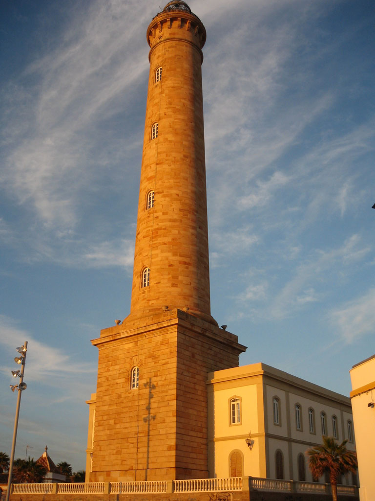
Chipiona Lighthouse
Chipiona
Chipiona Lighthouse stands on the Atlantic edge of Chipiona, a town in the Cádiz province of Andalusia, and is recognized as the tallest masonry lighthouse in Spain. What makes this lighthouse worth seeing? Also known locally as the Punta del Perro Light, the tower rises on a rocky headland of the same name, jutting into the Atlantic Ocean at the western tip of town. At 62 metres (205 feet), it is not only the tallest traditional lighthouse in Spain but also the seventeenth tallest of its kind anywhere in the world. Built in the 19th century, it remains fully active today, with its beam still guiding vessels toward the mouth of the Guadalquivir River. The lighthouse effectively serves as the landfall light for ships heading to Seville, marking the point where inbound traffic first picks up a clear coastal reference before turning toward the river mouth, located roughly 6 kilometres (3.7 miles) to the northeast. How do you get there? Punta del Perro sits on the outskirts of Chipiona, within easy reach of the town centre along the seafront promenade that runs west toward the coast. The white tower is visible from a considerable distance, making it a natural landmark for anyone walking, cycling, or driving through the seaside part of town. Because the headland borders Chipiona's beaches, most visitors combine a short walk to the lighthouse with time spent along the shoreline. What will you see once you're there? The centrepiece is the tower itself: a tall, white structure set on bare rock, with open Atlantic water on three sides. The setting is prized for its wide, uninterrupted sea views and for the waves that break directly against the rocks of Punta del Perro, a sight that becomes particularly dramatic in stronger wind or at high tide. Given its height and exposed position, the lighthouse is one of Chipiona's most recognisable symbols and a frequent subject of photographs of the town. The headland also makes for a strong sunset spot, with the light beginning its nightly work just as the sun drops toward the ocean horizon. When should you visit? The lighthouse is visible year-round, but the open coastline around it is at its best in the lower light of late afternoon or early evening, when the sun sits closer to the horizon and picks out the white tower against the rock. Summer brings more visitors to the area because of the neighbouring beaches, while the rest of the year the headland keeps the quieter, more rugged character typical of this stretch of the Cádiz Atlantic coast. Frequently Asked Questions Is Chipiona Lighthouse the tallest in Spain? Yes. At 62 metres (205 feet) tall, it is the tallest masonry lighthouse in Spain and the seventeenth tallest traditional lighthouse in the world. Where exactly is the lighthouse located? It stands on Punta del Perro, a rocky headland jutting into the Atlantic in the town of Chipiona, Cádiz province, about 6 kilometres southwest of the Guadalquivir River's mouth. Is the lighthouse still operational? Yes, it is an active aid to navigation. Its light still helps guide ships toward Seville, serving as a key coastal marker along this part of the Atlantic coastline. Can you walk to the lighthouse from central Chipiona? Yes, it sits at the western edge of town and is easily reached on foot or by bike via the seafront promenade, close to the town's main beaches.
-
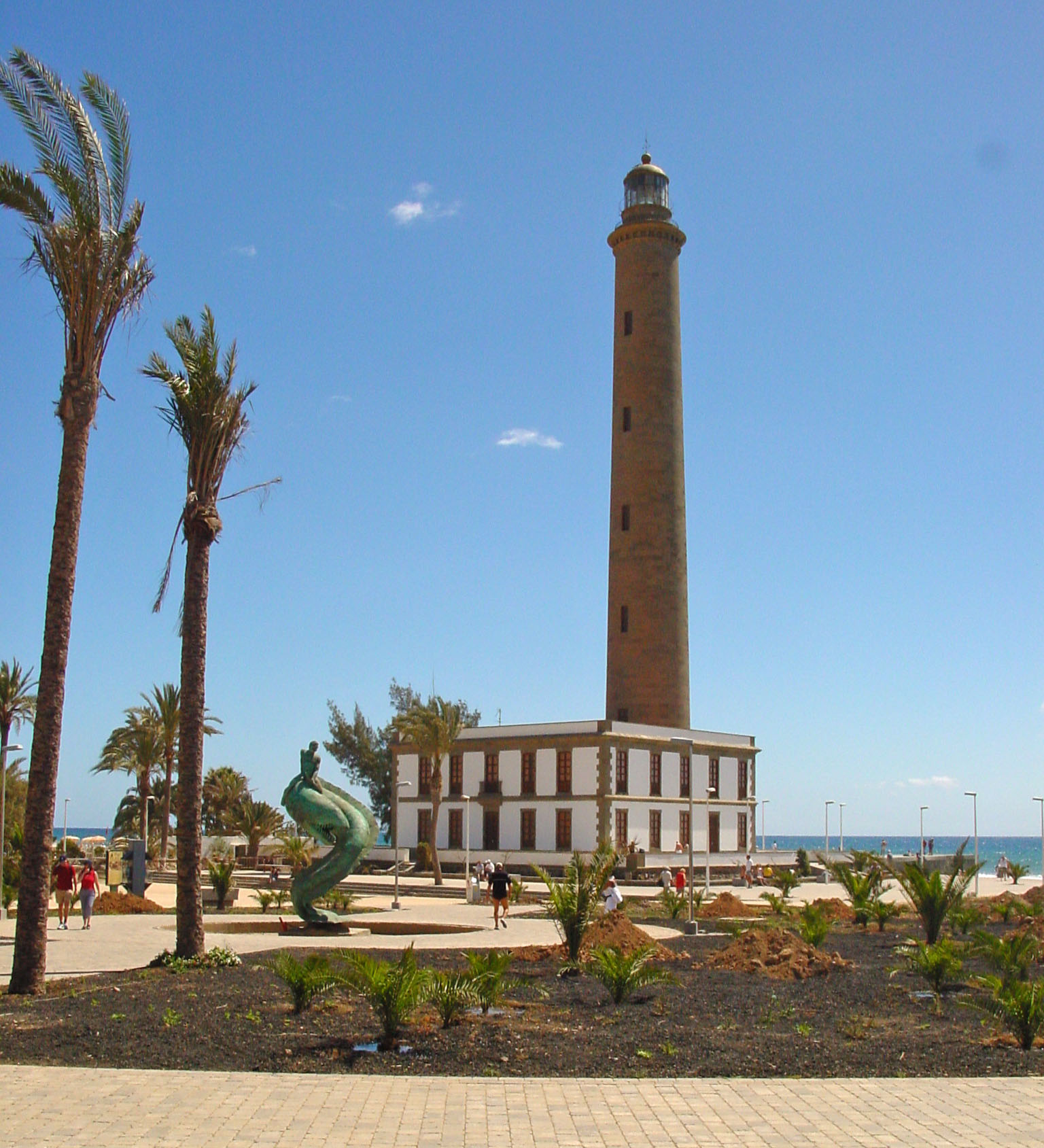
Maspalomas Lighthouse
San Bartolomé de Tirajana
Maspalomas Lighthouse stands at the southern tip of San Bartolomé de Tirajana, on the island of Gran Canaria. Built in the 19th century and still active today, it marks one end of Maspalomas beach, roughly 4 kilometres south of the resort's town centre, right next to the famous Maspalomas Dunes — one of the most recognisable landscapes anywhere in the Canary Islands. Where exactly is the lighthouse? The lighthouse sits on the very southern coastline of Gran Canaria, within the municipality of San Bartolomé de Tirajana. It borders the Maspalomas Dunes directly and juts out toward the ocean at the edge of the beach. It works as a natural landmark for anyone walking the coastal promenade that links Maspalomas with Playa del Inglés — the tower is visible from a distance and has become one of the visual symbols of this stretch of coast. How do you get there? Walking or cycling is the easiest option, following the beach and the promenade that runs through the dune area — the stroll from central Maspalomas usually takes a few dozen minutes. It's also a convenient destination if you're staying in hotels on either side of the resort, since the lighthouse sits right on the boundary between Maspalomas and the neighbouring tourist zones. The terrain around it is flat and well-trodden, so no special preparation is needed to reach it. What will you see there? The lighthouse itself is a working navigational aid rather than a museum, so its appeal for visitors lies mainly in its setting. From its base you get open views across the ocean, the long stretch of Maspalomas beach, and the rolling dunes that extend inland behind it. It's a popular spot for sunset, when the late-afternoon light throws the shape of both the dunes and the tower into sharp relief. Nearby, a seafront walkway with cafés and viewpoints gives good vantage points for photos of the lighthouse against the dunes. When is the best time to visit? Early morning or shortly before sunset are the calmest and most comfortable times — around midday, especially in summer, the beach area gets hot with little shade available. Since the whole area is fully exposed, it's worth bringing water, sunglasses and a hat regardless of the month, as the south of Gran Canaria has a dry, sunny climate almost year-round. Frequently Asked Questions Can you go inside the lighthouse? Maspalomas Lighthouse is a working navigational structure rather than a visitor attraction with regular public access — the main draw is the view from outside and the surrounding scenery, not climbing the tower. Can you walk there from Playa del Inglés? Yes, the seafront promenade connects Playa del Inglés with Maspalomas and leads straight toward the lighthouse and the dunes — it's one of the most popular walking routes in this part of the island. Are the Maspalomas Dunes right next to it? Yes, the lighthouse stands directly beside the Maspalomas Dunes, so most visitors combine both sights in a single walk. Is it a good spot to watch the sunset? Thanks to the open outlook, the proximity of the ocean and the dunes, the area around the lighthouse is one of the more popular sunset viewpoints on the south coast of Gran Canaria.
-
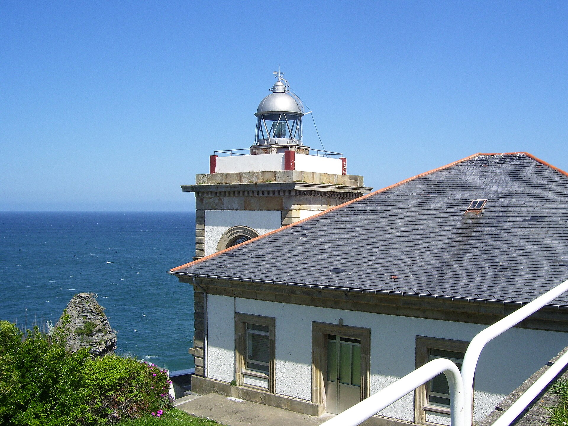
Faro de Luarca
Valdés
Faro de Luarca is a compact lighthouse perched on the rocky headland known as Punta Focicón, or Atalaya, in Luarca — the capital of the Valdés municipality on the western coast of Asturias. It stands guard over the entrance to the town's harbor and, together with Luarca's colorful houses and rugged Cantabrian coastline, forms one of the most recognizable images of the town. What is this place? The lighthouse dates back to the mid-19th century: construction was approved in 1861 and the light was first lit in 1862. It was built on the site of an earlier 16th-century fortification, originally raised to defend the harbor against French naval attacks and English privateers. That layered history — fortress first, lighthouse second — gives the Atalaya headland a significance that goes beyond navigation; it's a place tied closely to the town's defensive past. Right next to the lighthouse stands a small chapel, the Ermita de la Atalaya (Nuestra Señora la Blanca), and the town's parish cemetery sits nearby too, lending the whole headland a quiet, contemplative feel. How do you get there? The most enjoyable way to reach the lighthouse is on foot from Luarca's harbor. The coastal walking route takes roughly 45 minutes at an easy pace, winding first through the narrow streets of the old town and then climbing up toward the Atalaya headland. The climb is noticeable, since the lighthouse sits on a high cliff, but it rewards you with a gradually widening view over the harbor and the open sea. The local tourist information office can also point out the exact walking route if you'd rather not rely on signage alone. What will you see there? The lighthouse itself is a modest, whitewashed structure with a square tower — it's a working navigational aid, not a museum, so its interior isn't open to visitors. The real draw is the viewpoint it occupies rather than the building itself. From the Atalaya cliff, you get a sweeping panorama over Luarca's fishing harbor, the beaches flanking the mouth of the Río Negro, and the jagged coastline stretching in both directions. It's one of the best spots in town to take in Luarca's layout from above — the colorful houses tumbling down toward the port, the church, and the bridge crossing the river. When should you visit? Daytime visits give the best visibility and the most flattering light on the cliffs and water below. Late afternoon and early evening are particularly good for photography — watching the sun set over the Cantabrian Sea from the Atalaya headland is often one of the highlights of a stop in Luarca. Given the steep approach, it's worth avoiding the peak midday heat if you're planning the full walk up from the harbor. Frequently Asked Questions Can you go inside the lighthouse? No, Faro de Luarca is an active navigational light and its interior isn't open to the public. The appeal lies in the surrounding headland and the views from the cliff where it stands. How long does the walk from the harbor take? The coastal walking route from Luarca's harbor up to the lighthouse takes about 45 minutes at a relaxed pace, with a climb near the end. What else is worth seeing nearby? Right beside the lighthouse you'll find the small Ermita de la Atalaya chapel (Nuestra Señora la Blanca) and Luarca's parish cemetery — both make a natural addition to a visit to the lighthouse on the same walk. Does the lighthouse have any connection to the town's defensive history? Yes — it stands on the site of a 16th-century fort built to protect the harbor from French naval attacks and English privateers, before the site was converted into a lighthouse in the mid-19th century.
-
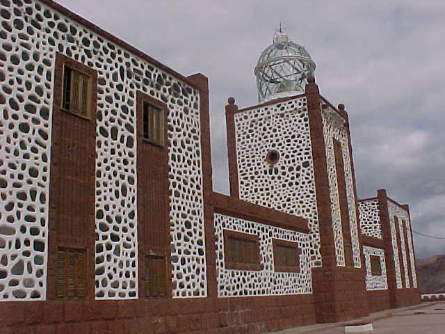
Punta La Entallada Lighthouse
Tuineje
Punta La Entallada Lighthouse sits on the eastern coast of Fuerteventura, in the municipality of Tuineje, right above the village of Las Playitas. It is still an active navigational light guiding ships along the Canary Islands' coastline, and for visitors it's less about the structure itself and more about the dramatic landscape surrounding it. Where is Punta La Entallada located? The lighthouse stands on a rocky headland on Fuerteventura's east coast, right next to Las Playitas, a small fishing village in the Tuineje municipality. It's one of the more remote points on the island's coastline, well away from the main tourist resorts, which is part of what makes it worth the trip. The surrounding terrain is marked by tall, steep cliffs dropping straight into the Atlantic. How do you get to Punta La Entallada? The easiest starting point is Las Playitas, reachable by car from the larger towns along the east coast. From the village, a road and walking/cycling trails follow the clifftops toward the lighthouse — a popular route for anyone who likes to combine sightseeing with some outdoor activity. The ground can be uneven and rocky in places, so comfortable footwear is worth having, especially if you plan to walk a longer stretch of the coastal path. The site sits close to 28.23°N, 13.95°W, on the island's eastern edge. What will you see there? The main draw of Punta La Entallada is the view. The lighthouse stands right at the edge of the cliffs, opening onto a wide panorama of the Atlantic and Fuerteventura's coastline. It's a good spot to take in the raw, volcanic character of the island's east coast — no development in sight, a sharp contrast between the white lighthouse tower and the dark rock, and a sea that shifts color through the day. The lighthouse itself remains a working navigational structure and isn't open for visitors to enter, but the surrounding clifftop paths and viewpoints are the real attraction. It's also a good place to step away from the island's busier beaches and resort areas for a while. When is the best time to visit? Fuerteventura is known for strong winds, and the east coast around Tuineje is no exception, so it's worth being prepared, particularly if you're planning a longer walk along the cliffs. Morning and late afternoon tend to offer the best light for photos and the most comfortable temperatures for walking. There's little shade along the way, so in summer it's worth bringing water and sun protection. The site is accessible year-round, and Fuerteventura's climate stays fairly stable across seasons, making it a reasonable stop at almost any time of year. Frequently Asked Questions Can you go inside Punta La Entallada Lighthouse? No, it's an active navigational lighthouse and isn't open to visitors. The main appeal is the surrounding cliffs and ocean views. Where should you start the walk to the lighthouse? The village of Las Playitas is the most convenient starting point, with a road and trails leading toward the lighthouse from there. Is the trail to Punta La Entallada difficult? The clifftop paths can be uneven and rocky in places, but they don't require special preparation — comfortable shoes and care near the cliff edges are enough. Is it worth combining the visit with other spots in Tuineje? Yes, the eastern coast of the Tuineje municipality has several quiet fishing villages that pair well into a single trip along the shoreline.
-
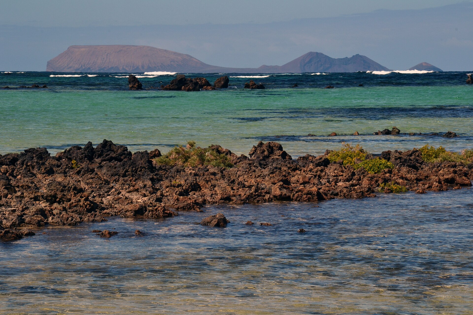
Punta Delgada Lighthouse
Teguise
Punta Delgada Lighthouse (also known as Alegranza Lighthouse) sits on Alegranza island, the northernmost point of the Canary Islands, administratively part of the Teguise municipality on Lanzarote. Where exactly is this lighthouse? Alegranza is the smallest and most remote island of the Chinijo Archipelago, a cluster of uninhabited islands and rocks lying north of Lanzarote. The lighthouse stands on the island's northern tip, facing the open Atlantic. Although it forms a separate island geographically, it falls under the Teguise municipality — the same one that governs the better-known La Graciosa. Its coordinates, roughly 29.40°N, 13.49°W, mark the northernmost inhabitable-adjacent point of the entire Canary Islands chain. What will you actually see there? The structure itself is a 19th-century lighthouse, still active and still doing the job it was built for: warning ships away from the rocky shoreline of the Chinijo Archipelago. The surroundings are stark and volcanic — black, jagged coast, no buildings, no trees, just wind, ocean, and light. It feels less like a Canarian resort island and more like an uninhabited outpost, because that's exactly what Alegranza is. The island and its surrounding waters fall within the protected natural area of the Chinijo Archipelago, which is why the land around the lighthouse has stayed so untouched — it's an important nesting ground for seabirds. How do you get to Punta Delgada Lighthouse? This is the question that matters most, and the honest answer is: you don't, not directly, and not as a regular tourist. Alegranza's protected status keeps public access restricted — there's no regular passenger ferry and no organized land excursions the way there are to nearby La Graciosa. The most realistic way to see the lighthouse is from a boat trip departing Órzola, on Lanzarote's northern coast, as part of a route that circles the Chinijo Archipelago; in good weather and visibility, the lighthouse is visible from the water. Failing that, viewpoints along Lanzarote's north coast can offer a distant glimpse of Alegranza's outline on a clear day. When is the best time to visit? Spring, summer, and early autumn tend to bring the calmest seas and the best visibility for boat trips around the Chinijo Archipelago. Winter months are often windier, which makes both the crossing and a good view of the lighthouse from the boat harder to come by. Whatever the season, it's worth checking marine conditions before setting out — the waters around Chinijo can turn quickly. Frequently Asked Questions Can you go inside Punta Delgada Lighthouse? No. It's a working navigational lighthouse, and Alegranza itself is a protected, access-restricted island — this isn't a site open to visitors. Is the lighthouse still operational? Yes, it remains active and continues serving its original purpose, guiding ships around the Chinijo Archipelago. Is Alegranza island inhabited? No, the island is uninhabited, which is part of why it has kept such a wild, untouched character. If you can't set foot on the island, where's the best place to see the lighthouse from? Boat trips from Órzola that circle the Chinijo Archipelago give the best chance, along with viewpoints on Lanzarote's northern coast where Alegranza is visible on clear days.
-
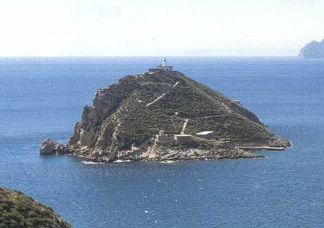
Escombreras Lighthouse
Kartagena
Escombreras Lighthouse stands atop Escombreras Island, guarding the entrance to Cartagena Bay in the Region of Murcia, Spain. Operated by the Cartagena Port Authority, it has guided ships toward one of southeastern Spain's most important harbors for over a century and a half. A brief history The original plans for the lighthouse date back to 1861, and its light was switched on for the first time on the night of 30 to 31 May 1864. During the Spanish Civil War the beacon was deliberately extinguished in October 1936, since the sight sat at the strategic entrance to a naval port and lighting the coastline would have posed a military risk. It stayed dark until the war ended. The structure visitors see today dates from 1971. It is a compact white tower just 8 metres tall, but it sits on a cliff 65 metres above sea level, which is why its beam carries so far despite the tower's modest height. Together with the lighthouses of Portmán and Cabo de Palos, Escombreras has been recognized as a site of heritage value for the region. How to get there? Escombreras Island forms part of Cartagena's industrial and port area, connected to the mainland by an artificial causeway; a refinery and power facilities now operate there, so the lighthouse itself is not open for close-up visits. The most reliable way to see it is from coastal viewpoints in Cartagena or on a boat tour of the bay, which typically passes close enough to the island for a clear view of the tower against the rocky headland. Local tourist information points can confirm which boat excursions are currently running. What will you see? From a boat deck or the right coastal vantage point, the lighthouse appears as a compact white tower perched high on a rocky bluff, set against the industrial skyline of the island below — an unusual pairing of a classic maritime beacon and modern port infrastructure in the same view. The light flashes white every five seconds and has a range of about 17 nautical miles (roughly 30.8 kilometres), so it is visible to the naked eye at night from the Cartagena waterfront. History enthusiasts will appreciate the site's strategic backstory: the entrance to Cartagena Bay has mattered for centuries, both commercially and militarily, and Escombreras has stood watch over it through peace and war alike. When to visit? The Region of Murcia enjoys a warm Mediterranean climate, so spring and autumn offer the most comfortable conditions and lighter crowds than peak summer. Boat tours around Cartagena Bay generally run through the summer season and the shoulder months of spring and autumn — it is worth checking current schedules with local operators before planning a trip. Frequently Asked Questions Can you go inside Escombreras Lighthouse? No — the lighthouse sits within Escombreras Island's industrial zone and is not open for interior visits. It can be observed from the outside, either by boat or from coastal viewpoints. What is the best way to see the lighthouse? A sightseeing boat tour of Cartagena Bay is the most practical option, along with coastal viewpoints in the city that offer a distant view of the tower against the island. When did the lighthouse first go into service? Its light was switched on for the first time in May 1864, though the current tower dates from 1971 and replaced the earlier structure. Has it operated continuously since then? No — in October 1936, during the Spanish Civil War, it was switched off for security reasons and only relit once the war had ended.
-
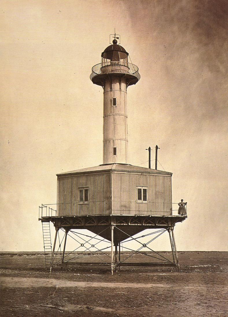
Far de la Banya
la Ràpita
Far de la Banya is a lighthouse standing at the tip of Punta de la Banya, the narrow sandy spit that closes off the Alfacs Bay (Badia dels Alfacs) from the south within the Ebro Delta. The site sits in the municipality of la Ràpita, in Catalonia, inside the protected area of the Ebro Delta Natural Park. Where exactly is the lighthouse? Punta de la Banya is a natural sand bar separating the open Mediterranean from the calm waters of Alfacs Bay. It forms the southernmost point of the delta and can only be reached on foot or by boat — no road leads to the tip itself. The lighthouse stands in an uninhabited setting surrounded by lagoons, salt flats and the seasonal floodplains typical of the delta. The story of the first lighthouse The original lighthouse on this spot was first lit in 1864, designed by engineer Lucio del Valle. Its tower was built of wrought iron and galvanized sheet metal, slightly conical in shape, painted a yellowish colour, topped with a polygonal lantern room and a natural-copper dome. Because of how isolated the location was — supplies arrived by sea or on a ten-kilometre walk from the Clot point whenever the route wasn't flooded — the lighthouse keepers were withdrawn as early as 1943, and the structure kept operating unattended for decades afterward. It served sailors for 114 years, until 1978. In 1984 the ironwork was dismantled and moved to the Port of Tarragona, where it was restored and can still be seen today as a piece of the region's industrial heritage. The current lighthouse and nature reserve Since 1978, a new lighthouse has stood at Punta de la Banya, built on the same spot as its predecessor. It is managed by the Tarragona Port Authority. The ground it occupies belongs to the Punta de la Banya Partial Nature Reserve, an area of very high ecological value that includes salt flats, lagoons and waterbird habitats. Because of this protection, the tower itself and its interior are closed to visitors year-round. How can you visit Punta de la Banya? Visitors can walk along the spit, but access is limited to a viewpoint at the end of the last section of the trail that remains open — beyond that point entry is restricted. The best base for the trip is la Ràpita, which also offers boat trips along the delta coastline that bring you close enough to see the lighthouse from the water. Bring water, sun protection and binoculars, since the area is one of the Ebro Delta's most rewarding spots for birdwatching. Frequently asked questions Can you go inside the Far de la Banya lighthouse? No. Neither the historic nor the current lighthouse is open to visitors — the surrounding land is protected, and public access stops at a designated viewpoint. Where is the original 19th-century lighthouse now? The original 1864 structure, designed by Lucio del Valle, was dismantled in 1984 and moved to the Port of Tarragona, where it stands restored as an industrial heritage landmark. How do you get to Punta de la Banya? La Ràpita is the most convenient starting point, offering a walking trail along the spit to the viewpoint as well as boat trips along the delta coast. Why is access to the spit restricted? Punta de la Banya lies within a Partial Nature Reserve protecting the salt flats, lagoons and waterbird habitats of the Ebro Delta, which is why visitor movement there is tightly controlled.
-
Tazones lighthouse
Villaviciosa
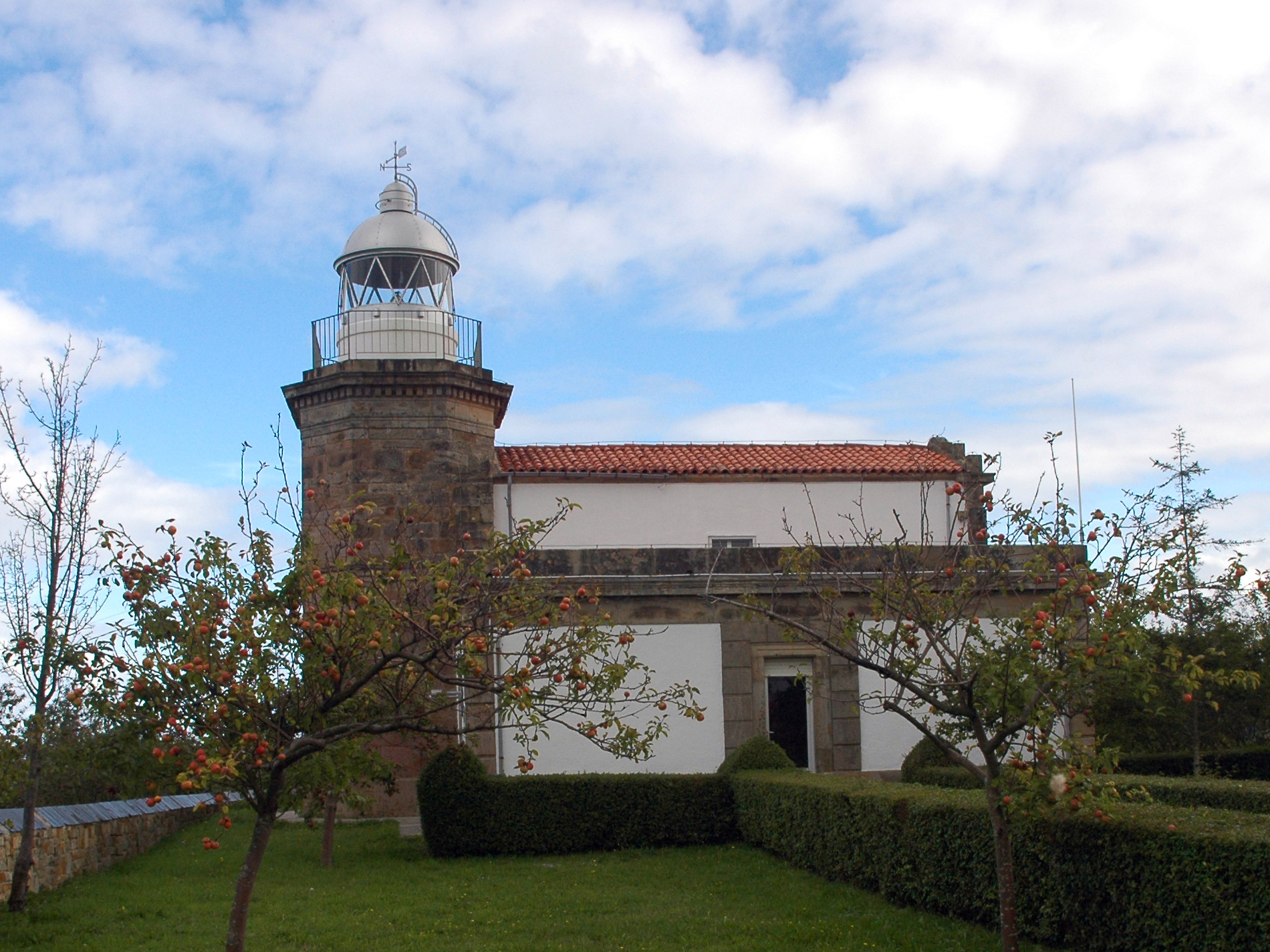
The Tazones lighthouse stands above the village of Tazones in the municipality of Villaviciosa, on the eastern coast of Asturias. Perched atop Punta del Olivo, on the western side of the mouth of the La Villa estuary, it has guided ships safely toward the harbor for more than 160 years. What does the lighthouse look like? The octagonal tower rises 11 meters and was built from rectangular sandstone blocks with beveled corners. A two-story service building, also constructed of sandstone, is attached to the tower and once served as the keeper's residence. On the tower's north face, a distinctive vertical stained-glass window carries an engraved inscription reading "Faro de Villaviciosa Año de 1864," marking the year the lighthouse first went into service. What is the history behind it? The lighthouse began operating in 1864, equipped with a sixth-order optical apparatus that produced a fixed white light visible from about 7 nautical miles away. Its history has not been entirely smooth: not long after construction, a lightning strike destroyed the original lamp and optical mechanism, forcing a replacement. In 1883 the original oil lamp was swapped for a paraffin one. Lightning struck again in 1926, damaging the optical apparatus once more. A major upgrade came in 1939, when an acetylene flasher was installed, producing a flash every 2.5 seconds with a range of 8 nautical miles, together with a new optical device. The lantern in use today dates from 1945. In 1953, an electromagnetic foghorn was added, sounding the letter "V" — for Villaviciosa — in Morse code on foggy days to warn ships away from the rocky coastline. What about the village of Tazones itself? The lighthouse overlooks Tazones, a small fishing village that for centuries depended on whaling. It was here, in 1517, that Emperor Charles V came ashore after sailing from Flanders to claim the Spanish crown — an event still remembered as a key part of the village's history. The colorful houses, narrow lanes, and working fishing harbor of Tazones make an atmospheric backdrop that adds to the lighthouse's appeal. How do you get to the Tazones lighthouse? Tazones sits a few kilometers from central Villaviciosa, reached most easily by car via the N-632 road or the local coastal routes. The lighthouse itself stands on a hill above the village, away from the main harbor area, so reaching it on foot from the village involves a short uphill walk. It's best to park in Tazones and cover the last stretch on foot, taking in the views over the estuary and coastline along the way. What will you see once you're there? The lighthouse itself is not open to the public for interior visits, but its silhouette against the cliffs and sea is one of the most recognizable sights on this stretch of the Asturian coast. From the area around the tower, you get sweeping views over the mouth of the La Villa estuary, the coastline toward Gijón, and the fishing village of Tazones with its harbor below. When is the best time to visit? Afternoon light tends to work best for photographing the tower, since the sun illuminates its front face at that time of day. The site is accessible year-round, though spring and early autumn bring more stable weather and fewer crowds than the height of summer. Frequently Asked Questions Can you go inside the Tazones lighthouse? No, the lighthouse remains an active navigational aid and is not open to visitors on the inside. How far is the lighthouse from central Villaviciosa? It stands in the village of Tazones, a few kilometers from Villaviciosa's town center, and is best reached by car. What does the inscription on the tower mean? The north face bears the inscription "Faro de Villaviciosa Año de 1864," recording the year the lighthouse entered service. What else is worth seeing in Tazones? The village is known as the place where Emperor Charles V landed in 1517, and its fishing-village character and colorful buildings draw visitors beyond the lighthouse itself.
-
Cape Cavalleria Lighthouse
es Mercadal
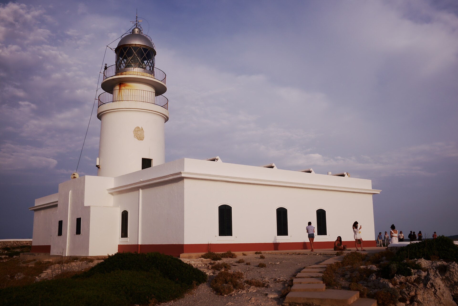
Cape Cavalleria Lighthouse is Menorca's oldest lighthouse, standing on the cliffs of Cape Cavalleria in the municipality of es Mercadal, at the very northern tip of the island. Built in 1857, it was meant to put a stop to centuries of shipwrecks along this stretch of coast — local records count more than 700 vessels lost here since the 16th century. Where exactly is the lighthouse? Cape Cavalleria stretches out into the sea as a narrow, roughly three-kilometre headland covered in low, wind-hardened scrub. The lighthouse sits at its far end, about 94 metres above sea level, making it one of the highest viewpoints on Menorca's north coast. From here you can take in both the open Mediterranean and the jagged cliff line running in either direction. How do you get there? A local road leads out from es Mercadal, crossing farmland before narrowing into a partly unpaved stretch that ends at the small car park by the lighthouse. From there it's just a few minutes on foot to the lighthouse itself. Sturdy shoes are worth packing — the ground around the headland is rocky, and the wind here can be strong even in midsummer. What is there to see on site? The lighthouse building itself is closed to visitors, but the surroundings offer more than the view alone. A small museum next to it explains the site's history in simple terms and covers the local flora, fauna, and the nearby Roman remains. A few hundred metres toward the coast lie the ruins of Sanitja, the ancient port of the Roman city of Sanisera — once a notable stop on Mediterranean trade routes. A modest café on site is a good spot to rest after exploring. When is the best time to visit? Cape Cavalleria is widely regarded as one of Menorca's best sunset spots, with oranges, purples and pinks reflecting off the sea at almost any time of year. It's worth timing the visit to leave the headland before dark, since the access road has no lighting. Early morning is another good window, when the car park is quieter and the light brings out the colour of the cliffs particularly well. What else is there to do nearby? A section of the Camí de Cavalls, the historic footpath that circles the whole island, runs across the headland. The stretch near the lighthouse makes for an easy, few-kilometre walk along the cliffs, with several viewpoints and a good look at the rock formations typical of this coastline. It's a natural way to pair the lighthouse visit with a longer stretch of northern Menorca's landscape. Frequently asked questions Can you go inside the lighthouse? No, the interior is closed to the public — visits cover the grounds, the small museum at the entrance, and the nearby Roman ruins. Do you need a car to get there? In practice, yes. Driving your own or a rented car from es Mercadal is the simplest option, though the final stretch of road is narrow and partly unpaved. Is there anywhere to eat at the lighthouse? There's a small café on site, though the choice is limited — think coffee or a drink rather than a full meal. Is it worth combining the visit with the Sanitja ruins? Yes — the Roman port ruins lie so close to the lighthouse that seeing both takes only a little extra time.
-

El Caletón
Garachico
El Caletón is a series of natural pools carved into volcanic rock in the town of Garachico, on the northwest coast of Tenerife. Born from a volcanic eruption in 1706, it is now one of the island's most popular spots for a swim in the Atlantic. How did the pools in Garachico form? On 5 May 1706, the Arenas Negras volcano (also referred to as Trevejo) erupted. Lava poured through the streets of the town, buried part of its buildings, and destroyed Garachico's harbour, sinking roughly 27 ships that were docked there at the time. When the molten rock reached the ocean, contact with the cold Atlantic water made it cool and solidify almost instantly, leaving behind a jagged, black lava shelf along the shoreline. Over time, seawater filled the hollows in that rock, and those hollows are the pools known today as El Caletón. No lives were lost in the eruption, but it permanently changed the town's fortunes: Garachico lost its position as Tenerife's leading port, a turning point dramatic enough that the event is sometimes described as the island's own "Pompeii." What are the pools like, and can you actually swim there? El Caletón isn't a single pool but a whole network of basins of different sizes cut into the black lava, including named sections such as Las Viejas, Los Niños and Los Chorros. Some are shallow and enclosed, others deep enough for proper swimming, so the site works both for families with children and for visitors looking for a longer swim. Because the pools sit within solid rock rather than sand, the seawater inside stays clear, and the surrounding lava also shelters the pools from stronger swell, which is why El Caletón has a reputation as one of the safer natural bathing spots on this stretch of coast. How do you get into the water, and what's nearby? Since the rock floor is uneven, metal stairs and platforms have been fitted along the edge of the pools to make getting in and out easier. A restored seafront promenade runs alongside the site, giving views out over the ocean and the surrounding cliffs. Right next to the pools stands the 16th-century San Miguel Castle, one of the few structures that survived the 1706 eruption, and the historic centre of Garachico, with its shops and restaurants, is just a short walk away, so a swim can easily be combined with exploring the old town. Frequently asked questions Is El Caletón suitable for children? Yes, some of the pools are shallow and shielded from the swell, making them suitable for families, while other, deeper sections are better suited to adults wanting a proper swim. Why does the site look the way it does, with black jagged rock everywhere? The pools were shaped by lava from the 1706 eruption of the Arenas Negras (Trevejo) volcano, which solidified rapidly on contact with seawater, leaving behind the dark, uneven rock formations that now hold the pools. Is there somewhere to eat or shop near the pools? Yes, El Caletón sits right next to Garachico's town centre, where you'll find restaurants and shops, plus a seafront promenade with views of the ocean and the San Miguel Castle. Is it hard to get into the water because of the rocky terrain? The rock floor is indeed uneven, but metal stairs and platforms have been installed along the pools to make entering and exiting the water safer and more comfortable.
-
Codolar de Torrenova
Ciutadella
Codolar de Torrenova is a rugged pebble cove on the northern coast of Ciutadella, on Menorca, lying just east of Punta d'en Nati. This is a spot for travelers drawn to raw, dramatic coastline rather than a conventional sandy beach. Where is Codolar de Torrenova? The cove sits on Menorca's northern shore, within the Ciutadella municipality, close to the Punta Nati lighthouse. This stretch of coast is steep and cliff-lined, with rock faces rising roughly 40 metres above the sea, framing an exposed view of the open Mediterranean. What does this beach actually look like? It isn't a sand beach at all — it's a codolar, a pebble-and-cobble shoreline typical of northern Menorca. The ground is stony and almost bare of vegetation, giving the whole area an almost desert-like feel. Pebbles and rock dominate rather than sand, and the cove sits fully exposed to wind and swell. Can you drive there? No. There's no road leading directly to Codolar de Torrenova. The nearest place to leave a car is the parking area by the Punta Nati lighthouse, from which you walk in on foot. The terrain is uneven, so care is needed on the descent toward the water. Is it safe to swim here? Swimming isn't common among either locals or visitors at this cove. The steep, rocky approach to the water and the lack of shelter from waves make it less forgiving than Menorca's typical beaches. There are no facilities of any kind — no showers, no food stalls, no equipment rental. How does it connect to the Camí de Cavalls? Codolar de Torrenova lies along the historic Camí de Cavalls, the coastal path that circles the whole island. The roughly 18-kilometre stage between Cala Morell and Ciutadella passes near Punta Nati and this cove, taking hikers through one of the most isolated stretches of Menorca's coastline. Is there anything historically significant nearby? Yes. Near Torrenova, on the rocks facing the cove, a memorial cross marks the loss of 156 French sailors who died when the ship General Chanzy sank in 1910. That wreck left a lasting mark on this part of the coast, and it explains why some of the stone markers in the area carry a memorial weight rather than just a navigational one. Who is this place for? Codolar de Torrenova mainly draws hikers working through the Camí de Cavalls and travelers seeking Menorca's more solitary, untouched coastline, far from the crowded beaches of the island's south. It suits a short stop during a trek — a look at the cliffs and open sea — rather than a day of sunbathing. Frequently Asked Questions Is Codolar de Torrenova a sandy beach? No — it's a pebble-and-cobble shoreline (a codolar), with no sand, framed by cliffs around 40 metres high. How do you get to Codolar de Torrenova? There's no direct road access. Park at the Punta Nati lighthouse and walk the rest of the way. Are there any tourist facilities there? None. No showers, food service, equipment rental, or other tourist infrastructure. What's the connection to the Camí de Cavalls? The trail stage between Cala Morell and Ciutadella passes near this cove, making it one of the route's coastal viewpoints.
-
Faro de Tapia
Tapia de Casariego
Faro de Tapia is a lighthouse standing on a small island just off the coast of Tapia de Casariego, in Asturias, northern Spain. It is the westernmost lighthouse in the whole region — only a few kilometres of coastline separate it from the mouth of the Eo River, which marks the border between Asturias and Galicia. How do you get there? The lighthouse sits on Isla de Tapia, an islet connected to the mainland by a roughly 100-metre breakwater. From the centre of Tapia de Casariego, the harbour and breakwater are just a few minutes' walk away, making this one of the most accessible lighthouses on the Asturian coast. The breakwater leads directly up to the tower, so no car or special gear is needed — just comfortable shoes, since the walkway can get damp from the sea spray. What will you see? The lighthouse was built in the mid-19th century at the initiative of Fernando Pérez Casariego, nephew of the Marquis of Casariego, who financed the project. The construction contract was signed in April 1857, and the lighthouse was officially lit for the first time on 1 September 1859 — making it one of the oldest working lighthouses in Spain, with more than 165 years of history. The original building had a square plan with an inner courtyard, and the attached tower consisted of two sections: an octagonal lower body and a decagonal upper one. The structure went through two major renovations, in 1922 and again in 1962. During the second one, the tower was given its current square exterior shape, and the word "Tapia" was inscribed in large letters on its north-facing wall. The lighthouse was electrified in 1944, when an electric flasher lamp was installed, producing its distinctive light pattern of groups of two flashes plus one — the sequence sailors use to identify it at night from a distance. Today the lighthouse is managed by the Port Authority of Avilés. From the platform around the lighthouse, the view opens onto the Atlantic Ocean and the jagged, cliff-lined coast of western Asturias — one of the most photogenic stretches of the so-called Costa Verde. It's also a convenient starting point for exploring the fishing harbour of Tapia de Casariego and the beaches nearby. When should you visit? The lighthouse can be visited year-round, but spring and early summer offer the best conditions for photos and walks along the breakwater, with longer days and a calmer Atlantic. In the evening, sunset light hitting the tower and the rocks makes for particularly striking shots. In autumn and winter, expect strong winds and waves breaking against the breakwater — dramatic to watch, but worth approaching with caution. Frequently Asked Questions Can you go inside the lighthouse tower? The lighthouse remains an active structure managed by the Port Authority of Avilés, so its interior is not open to visitors. You can, however, walk freely along the breakwater right up to its base and explore the surrounding area. How long is the walk to the lighthouse? From the centre of Tapia de Casariego, it's usually just a few minutes' easy walk along the breakwater — the distance is short, though it can feel more demanding in strong wind. What makes this lighthouse stand out among others in Asturias? It's the westernmost lighthouse in the region and one of the oldest still in operation in Spain, with a distinctive history of renovations and the word "Tapia" displayed on its tower. Are there other attractions nearby? The lighthouse sits right next to the fishing harbour and beaches of Tapia de Casariego, making it easy to combine a visit with a stroll around the town.
-
Punta Martiño Lighthouse
La Oliva
Punta Martiño Lighthouse is an active lighthouse on the island of Lobos, a small landmass in the channel between Fuerteventura and Lanzarote, administratively part of the municipality of La Oliva. Where is it and what is Isla de Lobos? Lobos is a tiny volcanic island just off the northern coast of Fuerteventura, separated from it by a narrow strait known as El Río. The entire island is a protected nature reserve — there are no permanent residents, no cars, and virtually no buildings apart from the facilities that support visitors and the lighthouse itself. Punta Martiño marks one of the island's landmark points, a rugged, rocky stretch of its coastline. The lighthouse is still operational, warning boats away from the rocks and shallows in the strait between the two islands, waters that can turn tricky because of strong currents. How do you get to Isla de Lobos and the lighthouse? The only way onto Lobos is by ferry from Corralejo, on Fuerteventura. Boats run regularly during the tourist season and the crossing itself takes only a few minutes. Once ashore, the whole island is explored on foot — there's no vehicle transport of any kind, and the trails, while well marked, can be stony and call for sturdy footwear. A walking trail across the interior of the island leads to the lighthouse. Bring water and sun protection, since Lobos offers almost no shade and both wind and sun are felt throughout the day. What will you see there? Punta Martiño Lighthouse is a distinctive white tower standing on a stark, rocky shoreline. From here the views stretch across the open ocean, the El Río channel, and, in the distance, the outlines of Lanzarote and Fuerteventura. The landscape around the lighthouse is unmistakably volcanic — black rock, low drought-resistant vegetation, and small coves with strikingly clear water. Beyond the lighthouse, the island offers walking trails up to its highest point, the volcanic cone of Montaña de la Caldera, which rewards the climb with a panoramic view of the whole area, as well as a route to the lagoon known as Puertito, a favourite spot among snorkellers. Since the entire island is a nature reserve, visitor numbers are managed and straying off the marked paths isn't permitted. When is the best time to visit? Spring and autumn are the most comfortable seasons for a visit, with pleasant temperatures and less intense heat than in the height of summer. Wind is a near-constant feature on Lobos, so dress accordingly. Because there's no shade anywhere on the island, it's worth avoiding the middle of the day during the hottest months and aiming for a morning visit instead. Keep in mind that daily visitor numbers to the island are capped due to its protected status, so booking your trip ahead of time significantly improves your chances of a relaxed visit to the lighthouse and the surrounding trails. Frequently Asked Questions Can you go inside Punta Martiño Lighthouse? The lighthouse is an active navigational structure, so visits are limited to viewing it from the outside as part of a walk across the island. How long does it take to walk to the lighthouse from the ferry landing? The route crosses the island's interior on a marked footpath; the exact time depends on your pace and chosen path, so it's best to set aside a full day for the trip. Can you buy food or water on Isla de Lobos? Facilities on the island are very limited, so it's safest to bring your own water and food from Corralejo before setting off. Is it worth combining the lighthouse visit with snorkelling? Yes — the waters around the Puertito lagoon are calm and clear, making it a popular spot to snorkel after exploring the lighthouse and the island's trails.
-
Faro de Punta Doncella
Estepona
Faro de Punta Doncella is a working lighthouse standing on the rocky Punta Doncella headland in Estepona, between the seafront promenade and the town's marina, in the province of Málaga, Andalusia. Together with the Punta Almina lighthouse in Ceuta, it forms a pair of navigation lights that help ships find safe passage through the Strait of Gibraltar. How do you get there? The lighthouse sits right in Estepona, directly on the coastal promenade that links the town centre with the marina, so it's easiest reached on foot along a walk by the beach. It's a favourite stop on the evening and late-afternoon strolls of both locals and visitors, offering sea views that, on a clear day, stretch across the strait to the African coast. Its coordinates are 36.416883, -5.15462. What's the history behind the lighthouse? Construction began between 1861 and 1863, designed by engineer Antonio Molina, and the light was first lit on 31 August 1863. The original tower was circular, but in 1922 it was replaced by the current structure — an octagonal tower built of quarried stone, 20 metres tall and standing 31 metres above sea level. That shape and material give the lighthouse a distinctive, weathered look that sets it apart from Estepona's newer harbour buildings. How does the lighthouse work today? The lighthouse operates automatically, powered electrically and controlled by a photoelectric cell that switches the light on at dusk without any need for a keeper. Its signal is a group of 1+2 flashes every 15 seconds, with a theoretical range of 18 nautical miles. That means Faro de Punta Doncella still plays a genuine role in shipping safety along the Costa del Sol, rather than serving as a purely decorative landmark. Where does the name come from? The name Punta de la Doncella, or "Maiden's Point," comes from a local legend dating back to the mid-16th century. According to the story, a young woman from a wealthy family fell in love with a man of much lower social standing, and unable to be with him, threw herself from the cliffs at this spot. While the tale is a legend rather than a documented event, it has become firmly embedded in local tradition and remains the accepted explanation for the headland's name. Why is it worth a visit? The lighthouse isn't a grand tourist attraction with visitor centres or guided tours, and that simplicity is exactly its appeal — a quiet viewpoint where you can step away from the bustle of the seafront for a few minutes. Its position next to the marina means fishing boats and yachts are often seen coming and going in the background, giving the spot a genuinely maritime feel. For anyone interested in the history of navigation, it's also a tangible link to the era when lighthouses were the only warning system ships had against coastal rocks. Frequently asked questions Where is Faro de Punta Doncella located? The lighthouse stands in Estepona, in the province of Málaga, on a headland between the seafront promenade and the town's marina, at coordinates 36.416883, -5.15462. When was the lighthouse built? The first version was built between 1861 and 1863 and lit on 31 August 1863; the current octagonal tower dates from 1922, when it replaced the earlier circular structure. What does the lighthouse do today? It operates automatically, emitting a group of 1+2 flashes every 15 seconds with a range of 18 nautical miles, and works alongside the Punta Almina lighthouse in Ceuta to guide ships through the Strait of Gibraltar. Where does the name Punta Doncella come from? According to a mid-16th-century local legend, the name refers to a young woman from a wealthy family who threw herself from the cliffs here after falling for a man of lower social status.
-
A Guía lighthouse
Vigo
A Guía Lighthouse stands on the summit of Monte da Guía in Vigo, in Spain's Galicia region, commanding sweeping views over the Ría de Vigo and out to the Cíes Islands. It is both a working aid to navigation and one of the city's best-known viewpoints. Why was a lighthouse built on this hill? Monte da Guía has held strategic value for centuries: from its summit, sentries could watch the mouth of the bay and guard the coastline against raiders and pirates. Remains of an ancient hillfort (castro) survive on the slope, evidence that the site was inhabited and defended long before any lighthouse stood there. Before a formal navigation light existed, fishermen's wives from Vigo would climb the hill and light bonfires to guide their husbands' boats safely back to port after dark. When was the first light lit? In 1842, merchants in Vigo pressed local authorities, through the British consul, to install a permanent light at the mouth of the Ría de Vigo to guide merchant vessels arriving past the Cíes Islands. The first lighthouse on Monte da Guía was lit on 27 April 1844. Beyond guiding trading ships, it also helped vessels find their way to the newly established quarantine station on the island of San Simón, which brought a sharp rise in shipping traffic to the port. What does the current lighthouse look like? The lighthouse standing today, designed by engineer Rafael de la Cerda, replaced the original structure and was lit in 1916. The tower rises 21 metres, with its light positioned 37 metres above sea level and a range of about 15 nautical miles. In 1934, the tower was clad in white tiles, giving it the distinctive look it still has today. A Guía is regarded as the first lighthouse built in Galicia after the Tower of Hercules in A Coruña, the oldest working lighthouse in the world. What else is there to do nearby? Monte da Guía today functions mainly as a hillside park and viewpoint, reached on foot via several paths, including the coastal Sendero Litoral. From the top, visitors can look out over Vigo's shipyards, the city's beaches, and a wide panorama of the ría stretching out toward the Cíes Islands. It's a popular spot for a walk, sunset photos, and a quiet break from the city, despite sitting close to the port and Vigo's industrial waterfront. Frequently asked questions Where is A Guía Lighthouse located? On the summit of Monte da Guía in Vigo, in the province of Pontevedra, Galicia, on Spain's northwestern coast. When was the lighthouse built? The first light was lit in 1844. The current tower, designed by Rafael de la Cerda, has been in operation since 1916. How tall is the lighthouse? The tower is 21 metres tall, with its light situated 37 metres above sea level. What is the range of its light? Around 15 nautical miles. Can visitors go inside the lighthouse? It remains an active navigation light, so public access is generally limited to the surrounding hillside, from where visitors can get close to the tower and take in the views over the bay. Why is Monte da Guía significant to locals in Vigo? It's one of the city's main viewpoints, a place residents visit to walk, relax, and take in views of the Ría de Vigo and the Cíes Islands.
-
Cabo de Ajo lighthouse
Ajo
Cabo de Ajo Lighthouse stands on a tall, rocky cliff above the Cantabrian Sea, right next to the village of Ajo in the municipality of Bareyo, in eastern Cantabria, northern Spain. It's one of those coastal landmarks that combines a genuine navigational role with a view that's hard to forget — open ocean, a jagged shoreline, and rock that drops sharply into the sea. How did this lighthouse come to be built? The story behind the Ajo lighthouse isn't a straight line. The idea was first proposed in 1907, but the project was shelved because the nearby Cabo Mayor lighthouse in Santander was considered sufficient to cover shipping in that stretch of coast. That assumption didn't hold up well. Three separate shipwrecks occurred in the area afterward, which was enough to bring the project back to the table. It was approved again in 1921, and the lighthouse itself was finally inaugurated in 1930. Half a century later, in 1980, the tower was rebuilt and modernized, introducing the automated system that still operates today. What does the Cabo de Ajo lighthouse look like? The tower is a concrete cylinder roughly 16 to 18 meters tall, though height alone doesn't tell the full story. Because it sits atop a high cliff, the light itself is positioned at around 71 meters above sea level — giving it a reach well beyond what the tower's own height would suggest. What makes it stand out from other Cantabrian lighthouses? For decades, the Ajo lighthouse was a purely functional structure with nothing visually distinctive about it. That changed in 2020, when Cantabrian artist Okuda San Miguel covered the tower in a colorful, geometric pattern inspired by local wildlife. The effect is hard to miss — the once-plain white tower turned into a vivid composition visible from a distance, which quickly made it one of the most photographed lighthouses in all of Cantabria. It's a rare case of navigational infrastructure doubling as a piece of public art. What else is worth seeing nearby? The lighthouse sits on a stretch of coastline known for dramatic cliffs and rock formations, close to spots like La Ojerada beach and Cabo Quintres. This is part of the area often called the Costa Quebrada — a rugged, fragmented coast that draws hikers walking the cliff paths and photographers drawn to the contrast between raw nature and human-made structure. How do you get to the Cabo de Ajo lighthouse? The lighthouse sits right by the village of Ajo, within the municipality of Bareyo, making it easy to reach from the main roads along the Cantabrian coast. For visitors driving from Santander, it's a relatively short trip along the shoreline that pairs well with a stop at nearby beaches and cliffside viewpoints. Frequently asked questions Can you go inside the Cabo de Ajo lighthouse? The lighthouse is an operational navigational aid and has been unmanned since it was automated in 1980, so visits are generally limited to viewing it from outside and from the surrounding cliffs. Why is the lighthouse painted in bright colors? The colorful design on the tower is the work of Cantabrian artist Okuda San Miguel, created in 2020, featuring patterns inspired by local wildlife — one of the main reasons the lighthouse has become a popular photography destination. How high above sea level is the light itself? Because it stands on a tall cliff, the light is positioned at around 71 meters above sea level, even though the tower itself is only about 16 to 18 meters tall. When was the Cabo de Ajo lighthouse built? It was inaugurated in 1930, after an earlier 1907 proposal was shelved and then revived in 1921 in response to a series of shipwrecks in the area. The tower was rebuilt and modernized in 1980.
-
Mera Lighthouses
Mera
The Mera Lighthouses are a pair of century-old range towers perched on the cliffs above Mera, a coastal village in the municipality of Oleiros, on Galicia's Atlantic coast near A Coruña. Officially they are alignment lighthouses guiding ships toward the port of A Coruña, but for visitors their real draw is simpler: this is one of the finest viewpoints over the whole estuary. Where exactly are the lighthouses? The towers stand on Punta de Mera, a narrow headland within the parishes of San Cosme de Maianca and San Xulián de Serantes, part of the Oleiros municipality. This stretch of coast, known as Costa de Dexo-Serantes, runs between A Coruña and Ares. The two towers themselves sit less than 300 metres apart, at different elevations on the headland — a layout that directly reflects their original navigational purpose. How do you get there? Mera sits on the coastal road connecting A Coruña with Ares and Betanzos, so driving is the easiest option, with parking available close to the lighthouses. A short, well-marked footpath also runs along the cliffs to the viewpoint, popular with locals from nearby towns for an evening walk. Mera itself is a well-known local summer resort, so public transport from A Coruña is also a workable option, especially in season. What will you actually see? Two white, octagonal towers topped with lattice-work balustraded terraces — the smaller one, known as Faro Pequeño, stands about 11 metres tall, while the second tower, built on higher ground, reaches around 14 metres. Both are publicly owned but closed to visitors on the inside; the real payoff is the view outward. From the cliff edge you get roughly 270 degrees of the Gulf of Artabro: the mouths of the A Coruña, Ares and Betanzos estuaries, with Ferrol visible further along the coast. On a clear day the Sisargas Islands and part of the Costa da Morte come into view too. The old lighthouse keepers' house has been converted into Aula do Mar, a small visitor and education centre dedicated to the natural monument of Costa de Dexo-Serantes, covering the local coastal ecosystem. A short walk away are the beaches of Portelo and Espiñeiro, a good spot to round off the visit. What's the history behind them? The decision to build the range towers dates back to 1904, intended to help ships navigate the tricky entrance to the Ría de A Coruña alongside the existing Oza light. The project dragged on for years; an earlier design proved technically unworkable, and the final version, by engineer Rafael de la Cerda, was only completed in 1917. Electricity did not reach the towers until 1932. Since then, their distinctive white octagonal silhouette has barely changed. When is the best time to visit? Aim for a clear day, when the view across the gulf reaches furthest, or come in the evening — sunset over the Gulf of Artabro is a well-known local draw and pulls people up to the cliffs. Spring and autumn mean fewer visitors, while summer adds the option of a swim at the nearby beaches. Frequently Asked Questions Can you go inside the Mera lighthouses? No, both towers are active navigational structures and are not open to the public inside. The appeal is the surrounding viewpoint, not the interior. Is there an entrance fee? No, reaching the lighthouses and the viewpoint is free and possible year-round. How many lighthouses are there in Mera, and what's the difference? There are two: the smaller Faro Pequeño (about 11 m) and a taller second tower (about 14 m), standing less than 300 metres apart — together they form an alignment system for ships heading into A Coruña. What else is there to see nearby? The restored keepers' house now houses the Aula do Mar visitor centre, and the beaches of Portelo and Espiñeiro are just a short walk away.
-
Barbaria Lighthouse
Formentera
Barbaria Lighthouse (Far de Cap de Barbaria) stands at the southernmost tip of Formentera — and in fact the southernmost point of the entire Balearic Islands. It sits on a stark, limestone plateau where dry, low scrub and the absence of trees have earned the surrounding landscape the nickname of a "lunar" terrain. What's the story behind the lighthouse? The lighthouse was first planned back in 1924, but construction only went ahead in 1971 — for decades this stretch of coastline had no navigational signal at all, even though the lighthouse at La Mola, on the opposite side of the island, had been guiding ships since 1862. The tower itself is just under 17 metres tall with a 3-metre diameter, but because it sits atop a high cliff, its light actually shines from roughly 78 metres above sea level. The beam can be seen from up to 18 nautical miles away, making it an important marker for vessels heading toward the African coast — Cap de Barbaria is the closest point in the whole Balearic archipelago to the African continent. Close to the lighthouse stands a much older structure: a stone watchtower built around 1760 on the orders of the Spanish Crown, used to keep watch over the coast against pirate raids. The gap between this 18th-century defensive tower and the 20th-century lighthouse says a lot about how isolated this corner of the island remained for so long. How do you get there? A narrow road branches south from the main route connecting Sant Francesc Xavier with the area near Es Caló, leading toward Cap de Barbaria. The final stretch is an unmarked, rocky track across the plateau, with no pavements or tourist facilities along the way — a car, scooter, or bicycle is really the only practical option, and it's worth bringing water. Public transport doesn't reach this far, so your own wheels are essentially required. What will you see once you're there? Beyond the lighthouse and the nearby watchtower, the area draws visitors for its raw, almost desert-like scenery: flat rock formations, sparse vegetation, and open sea views with no buildings in sight. It's one of Formentera's most valued spots for watching the sunset — the lack of settlements and artificial light also makes the night sky here notably dark, which appeals to stargazers as well. Small limestone caves dot the cliffs nearby, worth a look if you're walking around the plateau. When is the best time to visit? Since there's no shade or shelter from the wind up on the plateau, late afternoon heading into sunset is the best window — temperatures ease off and the views are at their most striking. At midday, especially in summer, the exposed terrain gets intensely hot with nowhere to escape the sun, so a hat and plenty of water are essential. Frequently Asked Questions Can you go inside the lighthouse? No, the lighthouse is an active navigational structure and is not open to visitors inside — the appeal is the view of the tower itself and the surrounding landscape. Is it reachable by public bus? No regular public transport reaches this spot — you'll need your own vehicle, whether a car, scooter, or bicycle. Why does the area look like a "lunar landscape"? It comes down to the dry limestone ground, strong winds, and the near-total absence of trees, leaving only low scrub suited to harsh conditions. Is it worth visiting at sunset? Yes — it's one of Formentera's most popular sunset spots thanks to the open sea views and the complete lack of buildings nearby.
-
Punta de Melenara Lighthouse
Telde
Punta de Melenara Lighthouse is a working maritime lighthouse standing on the eastern coast of Gran Canaria, within the municipality of Telde. It's also commonly called Faro de Taliarte, after the nearby coastal settlement of Taliarte that it borders. Built in the 20th century, the lighthouse remains active today, guiding ships safely along this stretch of coastline. Where exactly is the lighthouse located? Punta de Melenara Lighthouse sits on a small headland on Gran Canaria's east coast, in Telde — the island's second-largest city, a short drive south of the capital, Las Palmas de Gran Canaria. The lighthouse marks the point where land meets ocean, right next to Melenara beach and the small harbour settlement of Taliarte, which gives the lighthouse its alternative name. This stretch of coast is quieter and less touristy than the resort areas in the south, so the surroundings still feel like an authentic fishing-and-beach corner of the island. How do you get there? Driving is the easiest option: the coastal road on Gran Canaria's east side connects Las Palmas de Gran Canaria with Telde and continues on to Taliarte and Melenara, from where the lighthouse is clearly visible along the shoreline. Without a car, local buses run between Las Palmas and Telde, and from there it's a short taxi ride or walk down to the coast. It's worth building the visit into a longer walk along the seafront promenade, which links several coastal spots in this part of the island. What will you see when you visit? Punta de Melenara Lighthouse is a working navigational aid, not a visitor attraction with an interior open to the public, so plan to admire it from the outside. The tower itself rises above the shoreline and acts as a clear landmark, visible both from land and from boats out at sea. Around it stretches an open view of the Atlantic, with the sandy Melenara beach close by and the small Taliarte harbour, where local fishing boats moor. It's a good spot for an unhurried walk, watching the ocean, and photographing the coastline away from the busier tourist crowds. When is the best time to visit? The east coast of Gran Canaria enjoys mild weather year-round, so the lighthouse can be visited at any time of year. Early morning and late afternoon light works best for photos, softening the glare off the water and making a coastal walk more comfortable. If you plan to combine the visit with time on Melenara beach, aim for calmer days, since this side of the island can pick up noticeable wind outside the quieter months. Frequently Asked Questions Can you go inside the lighthouse? No — Punta de Melenara Lighthouse is an active navigational lighthouse, so it's viewed from the outside rather than opened to visitors. Why is it also called Faro de Taliarte? It sits right next to the coastal settlement of Taliarte, part of the municipality of Telde, which is where the alternative name comes from. Is the area around the lighthouse good for a relaxed visit? Yes — Melenara beach and Taliarte harbour offer a calmer, more local alternative to the busier resorts on Gran Canaria's south coast. Can this be combined with other things to see in Telde? Telde is the island's second-largest city with its own historic centre, so a stop at the lighthouse fits naturally into a broader day exploring the east coast.
-
Beacon of Punta Barca
Muxía
Beacon of Punta Barca is a small maritime light standing on the rocky headland of Punta da Barca, right next to Muxía, a fishing town on Galicia's Costa da Morte. It is a modest structure, but its white flashing light and the sweeping coastal views around it make it one of the memorable stops along this stretch of the Atlantic shore. How do you get there? Muxía sits on Galicia's western coast, in the province of A Coruña, and is easiest to reach by car — the drive from Santiago de Compostela takes roughly ninety minutes. The beacon stands at the tip of the headland, a short distance past the Sanctuary of Nosa Señora da Barca, which has its own access road and parking area. From there it is only a few minutes on foot across the rocks to reach the tower itself. The headland is also part of the Camiño dos Faros, a coastal hiking trail linking the lighthouses of the Costa da Morte — its sixth stage passes directly through this point. What will you see? The structure itself is compact: a cylindrical tower roughly 11 meters tall, wrapped by a double gallery near the top. A lamp at the summit emits a white flash every 4 seconds, visible from up to 10 nautical miles (around 16 km) out at sea. The beacon is managed by the Port Authority of A Coruña. The tower you see today is not the original one. The first light at this site went into service in 1898, and it was replaced by the current structure in 1981. The beacon itself, though, is only part of the appeal — it sits amid the raw scenery typical of the Costa da Morte: jagged rock formations, heavy Atlantic swell, and an open ocean horizon that stretches for miles on a clear day. Just a short walk away stands the Sanctuary of Nosa Señora da Barca, one of Galicia's best-known pilgrimage sites, tied to local legends about the rocking stones Pedra de Abalar and Pedra dos Cadrís. This combination of a rugged headland, a working sea beacon, and a site of religious devotion gives the area a distinctive, almost mystical character, appreciated equally by walkers finishing the Camino de Santiago's Fisterra-Muxía route and by travelers drawn to wild Atlantic scenery. When is the best time to visit? The months between May and September offer the most reliable conditions, with longer days and calmer weather making it easier to walk the rocky ground around the beacon and the sanctuary. That said, the Costa da Morte is known year-round for strong winds and frequent fog, so it is worth checking the forecast before setting out — on clear evenings, sunsets from this headland rank among the most striking on the entire Galician coast. Outside the summer months, the site is noticeably quieter, which suits visitors looking for solitude and a closer connection with the raw Atlantic landscape. Frequently Asked Questions What is the Beacon of Punta Barca? It is a small maritime beacon on the Punta da Barca headland near Muxía, about 11 meters tall, emitting a white flash every 4 seconds visible up to 10 nautical miles out at sea. How old is the beacon? The first light at this location entered service in 1898. The tower standing today, which replaced the original, was built in 1981. Is there anything else to see near the beacon? Yes — a short walk away stands the Sanctuary of Nosa Señora da Barca, one of Galicia's most important pilgrimage sites, and the whole headland offers the dramatic scenery typical of the Costa da Morte. Can you reach it on foot as part of a pilgrimage route? Yes, the Punta Barca headland lies along the Fisterra-Muxía extension of the Camino de Santiago and is also the sixth stage of the Camiño dos Faros trail, so many visitors arrive here while hiking the Costa da Morte.
-
Punta Cumplida Lighthouse
Barlovento
Punta Cumplida Lighthouse stands at the northernmost tip of La Palma, in the municipality of Barlovento, in the Canary Islands. It is one of the oldest and most recognizable maritime landmarks on the island, rising above a wild, volcanic coastline where the Atlantic crashes against black rock. What is the history behind the lighthouse? Construction was authorized in 1857, work began in 1861, and the light was first lit in April 1867. It was the first major public works project carried out on La Palma in the 19th century, which says a lot about how important the lighthouse was for shipping around the island. The original lamp burned olive oil, later switching to paraffin and then petroleum. In 1997 the lantern room was replaced and a second balcony was added. The real leap forward came in 2011, when Punta Cumplida became the first lighthouse in Europe to use high-power LED lamps, giving it a range of 24 nautical miles. What does the tower look like? The tower stands slightly over 33 meters tall and is defined by twelve windows running along its height, giving it a distinctive, elongated silhouette visible from a distance. It sits on a rocky headland surrounded by the vegetation typical of northern La Palma, facing the open ocean. How do you get to Punta Cumplida Lighthouse? The lighthouse is located in the municipality of Barlovento, on the northern tip of La Palma, reached by a local road leading from the town center toward the coast. It is one of those corners of the island best explored by car: the drive passes through typical northern La Palma scenery, including laurel forest and terraced farmland, with ocean views opening up along the way. The lighthouse's coordinates are 28.83901, -17.77814, which makes it easy to find in any navigation app. What else is there to see nearby? Part of the lighthouse building has been converted into a small hotel, a rare chance to spend the night inside a working lighthouse of this kind. Even without staying over, walking up to the base of the tower and taking in the ocean view from this spot is one of the more memorable things to do in Barlovento. Along the same stretch of coast are the Fajana natural pools, carved into volcanic rock and filled by ocean water — a popular spot for a refreshing swim after walking along the cliffs. When is the best time to visit? The coastline around Punta Cumplida is exposed to wind and swell, so weather here tends to be more changeable than in more sheltered parts of La Palma. Spring and autumn generally bring the most pleasant conditions for visiting, with mild temperatures and clearer skies that make it easier to enjoy the view of the lighthouse and the open Atlantic. Frequently Asked Questions Can you stay overnight at Punta Cumplida Lighthouse? Part of the lighthouse building now operates as a hotel, offering the chance to sleep inside this historic structure. It is worth checking availability and booking ahead, since space is limited. How tall is the lighthouse tower? The tower is slightly over 33 meters tall and has twelve windows along its facade. When was Punta Cumplida Lighthouse built? Construction was authorized in 1857, work began in 1861, and the light was first lit in April 1867. Is the lighthouse still operational? Yes, it is fully active. Since 2011 it has used high-power LED lamps with a range of 24 nautical miles, making it the first lighthouse in Europe to adopt this technology.
-
Arenas Blancas Lighthouse
Villa de Mazo
Arenas Blancas Lighthouse is an active lighthouse on the Canary Island of La Palma, standing in the municipality of Villa de Mazo near the small village of La Salemera. The larger town of Mazo lies about 8 km (5 miles) to the northwest. Where is the lighthouse and how do you get there? The lighthouse sits on La Palma's southeastern coast, within Villa de Mazo — one of the municipalities along the route between the island's capital, Santa Cruz de La Palma, and the volcanic south of the island. Driving is the easiest way to reach it, following the coastal road toward La Salemera; La Palma is a compact island, so most coastal towns are within half an hour's drive of each other. Keep in mind that the island's terrain is steep and mountainous, so coastal roads tend to be narrow and reward unhurried driving. What should you know about the lighthouse itself? Arenas Blancas is a fully operational lighthouse, still used to mark the coastline and guide ships sailing along La Palma's southeastern shore. Its name translates from Spanish as "white sands" — in a region where the coastline is largely shaped by black volcanic sand, a name like this usually points to a specific beach or stretch of shore the lighthouse was named after. What else is worth seeing nearby? Villa de Mazo lies in the southern part of La Palma, close to the areas shaped by the island's volcanic activity — it's in the neighboring municipality of Fuencaliente that the San Antonio and Teneguía volcanoes erupted during the 20th century, followed by the Tajogaite eruption in 2021. The whole island is a UNESCO Biosphere Reserve and one of the few places in the world with Starlight certification, thanks to its exceptionally dark, light-pollution-free skies — a big draw for stargazers and astronomy enthusiasts. Villa de Mazo itself is known for traditional handicrafts, including hand-made openwork embroidery called calados, and the surrounding lowlands are dotted with banana plantations typical of the island's coastal areas. When is the best time to visit? La Palma enjoys a mild, subtropical climate year-round, so the lighthouse and its surroundings can be visited in any season. Conditions are most pleasant for exploring the coast from spring through early autumn, when temperatures are stable and the sea calmer. In the evening, as dusk falls, the area around the lighthouse makes a good spot for stargazing, given the island's reputation for some of the darkest night skies in Europe. Frequently asked questions Can you go inside Arenas Blancas Lighthouse? Available information doesn't indicate regular public access to the interior — it's a working navigational aid rather than a visitor attraction with scheduled tours. How far is the lighthouse from the town of Mazo? The larger town of Mazo lies about 8 km (5 miles) northwest of Arenas Blancas Lighthouse. What does the name "Arenas Blancas" mean? It's Spanish for "white sands," most likely referring to a nearby stretch of coastline the lighthouse takes its name from. Are there other attractions worth visiting nearby? Yes — the neighboring municipality of Fuencaliente is home to the San Antonio and Teneguía volcanoes, and the whole of La Palma is a certified dark-sky destination popular with astronomy enthusiasts.
-
Faro Punta A Atalaia
San Cibrao
Faro Punta A Atalaia is a lighthouse standing on a rocky headland at San Cibrao (San Ciprián), in the municipality of Cervo, province of Lugo, Galicia. The site has long served as a landmark for sailors travelling along Spain's northern coast, and its most distinctive feature is a pair of light towers from two different eras standing side by side. Where exactly is the lighthouse located? The lighthouse stands on Punta Atalaia, also known as Punta de San Cibrao, in the parish of Santa María de Lieiro. The site was originally an island, but today it is connected to the mainland by a narrow sandy strip roughly 150 metres long and just over 100 metres wide, forming a small peninsula. The highest point of this headland reaches 34 metres above sea level, giving wide views over the ocean and the surrounding coastline. Why was a lighthouse needed here? The construction of a navigational light at the Atalaya de San Cibrao was formally approved in 1860, when a sixth-order lighthouse was authorised for the site. The push behind the project came from the 19th-century boom of the Sargadelos factory in Cervo, a small industrial complex that included a foundry, a blast furnace, worker housing, and even a chapel. The increased ship traffic carrying goods to and from the factory required reliable marking of this rocky and hazardous stretch of coast. How many towers stand here, and how do they differ? Two lighthouses stand on Punta Atalaia. The first, built in 1864, is square in shape and forms part of an attached building. The second tower, considerably more recent, dates from 1979 and is a free-standing cylindrical structure painted with white and black stripes. This newer tower entered service in 1983, taking over as the main navigational light — its white beam is visible from 20 nautical miles, making it far more effective than its historic predecessor. What is worth knowing when visiting this spot? The name "Atalaia" (rendered "Atalaya" in Castilian Spanish) means watchtower or lookout point, a fitting description for a site that has served as a natural vantage point over the ocean for centuries. The presence of two towers from different centuries makes Punta Atalaia an interesting stop for anyone curious about the history of lighthouses in Galicia, while also offering sweeping views over the Rías Altas coastline and the fishing town of San Cibrao below. Frequently asked questions Where is Faro Punta A Atalaia located? In San Cibrao (San Ciprián), municipality of Cervo, province of Lugo, Galicia, on the Punta Atalaia headland, which is connected to the mainland by a sandy strip. When was the first lighthouse here built? Construction was approved in 1860, and the square tower attached to a building was completed in 1864. Is there only one tower at Punta Atalaia? No, there are two — the historic 1864 tower and a newer cylindrical, white-and-black-striped tower built in 1979 and put into service in 1983. How far can the new tower's light be seen? The new lighthouse's white light reaches 20 nautical miles. Why was a lighthouse built at this location? Because of growing ship traffic linked to the 19th-century growth of the Sargadelos factory in Cervo and the need to mark a dangerous rocky coastline.
Earn badges for the places you visit
Download NextOnTrip, discover new places and check off your trails.