Nature in Portugal
A guide to 14 Nature in Portugal — with descriptions, photos and traveler visits from the NextOnTrip community. Locations spread across 13 cities and towns. Most visited by the community: Pedras Parideiras da Serra da Freita, Pico do Facho, Corre Agua.
-
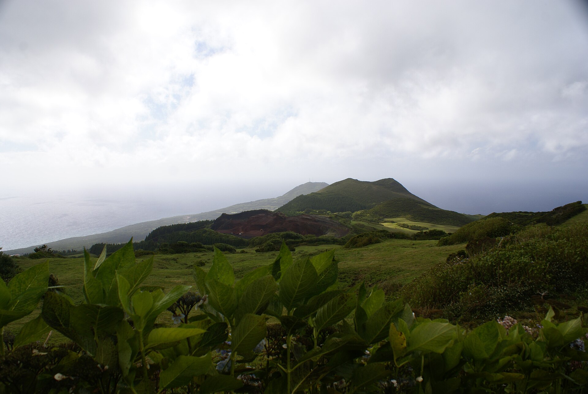
Cabeço dos Trinta
Capelo
Cabeço dos Trinta is an old basaltic volcanic cone in the parish of Capelo, in the municipality of Horta, on the island of Faial in the Azores. It stands at roughly 755 metres above sea level and is one of the points from which the popular levada trail begins. Here is what to know before you go. What is Cabeço dos Trinta? The hill belongs to the Capelo Volcanic Complex, a line of ash and cinder cones stretching between the Caldeira do Faial to the east and the Capelinhos volcano to the west. Along the same alignment you will find Cabeço Gordo, Cabeço Verde, Pingarotes, the Cabeço do Fogo volcano and Cabeço do Canto. Together they tell the volcanic story of the western part of the island. What can you see here? You can go inside the formation through a tunnel and reach the middle of the crater. It is now covered by natural vegetation, including heather and holly. It is a quiet spot for anyone who wants to see Azorean nature up close rather than from a viewpoint alone. How do you get to Cabeço dos Trinta? The usual way is the PR3FAI trail, known as the Levada. It follows an old water channel built in the 1960s to feed the island's hydroelectric station. Sources give slightly different figures, from about 7.6 to 7.7 km one way, with an average time of around 2.5 hours. If you return the same way, the full out-and-back is roughly 14 to 15 km and about 4 hours of walking. The trail is rated moderate. You can start near Cabeço dos Trinta in Capelo and finish in Cedros, or do it the other way round. Most hikers begin at Cabeço dos Trinta and walk north toward Cedros. What to expect on the trail The path runs through forest, tunnels and mossy stretches, with the steady sound of running water beside you. It is used for hiking, walking, nature trips and birdwatching, with views over the volcanic landscape of the Capelo complex. Frequently asked questions Where is Cabeço dos Trinta? In the parish of Capelo, municipality of Horta, on Faial in the Azores. How high is it? About 755 metres above sea level. Can you enter the crater? Yes, a tunnel leads to the middle of the crater. The interior is covered with natural vegetation such as heather and holly. How long does the Levada trail take? About 2.5 hours one way and around 4 hours out and back. It is a moderate route. Where should I start? Most people start at Cabeço dos Trinta and walk north to Cedros, though the opposite direction works too.
-

Miradouro de Santa Catarina
Miradouro de Santa Catarina is a viewpoint terrace in Lisbon, set on one of the city's seven hills just below the Bairro Alto and almost parallel to Bica. Locals also call it Adamastor, after the sculpture that presides over the square. It is one of the most popular sunset spots in the city. What can I see from Miradouro de Santa Catarina? The panorama takes in the Tagus estuary, the red 25 de Abril Bridge and the rooftops of the surrounding neighbourhoods. On the far bank of the river you can also pick out the Christ the King monument. For decades this was where people came to watch ships pass, and that calm river outlook is still the main attraction. Who is Adamastor? The stone giant was unveiled in 1927 and is the work of sculptor Júlio Vaz Júnior. Adamastor comes from the epic poem "The Lusiads" by Luís de Camões, where the poet created him as a personification of the Cape of Storms, the headland later renamed the Cape of Good Hope. Many Portuguese ships were lost off its coast until Bartolomeu Dias rounded it in 1488. The figure is carved into a rock facing the Tagus, as if still guarding the sea lanes. What is the atmosphere like? The miradouro tends to feel less crowded with tour groups than some other Lisbon terraces, and it draws a younger crowd. In the evening, street musicians play, conversation carries on, and people sit on the amphitheatre-style steps added in a 2013 renovation, often with a drink from the kiosk. The mood is relaxed and social, and much more of an evening place than a morning one. When should I go? Sunset is the best time. In autumn the sun sinks behind the 25 de Abril Bridge, which makes for one of the prettiest scenes in town. If you want quiet and a clear photo of the statue, come earlier in the day. Late afternoon and evening bring crowds and a livelier soundtrack. How do I get there? The viewpoint sits in the Centro Histórico, close to the Bairro Alto and the Ascensor da Bica funicular, so it pairs easily with a walk through the neighbouring districts. The terrain is hilly, so comfortable shoes help. Frequently asked questions Why is it called Adamastor? Because of the stone sculpture of the giant from Camões's "The Lusiads" that stands on a rock above the square. When was the statue made? It was unveiled in 1927 and created by Júlio Vaz Júnior. Is sunset worth it? Yes, that is the peak moment here, especially in autumn when the sun drops behind the 25 de Abril Bridge. Is there an entrance fee? No, it is an open-air public viewing terrace. What else is nearby? The Bairro Alto, the Bica district and the Ascensor da Bica, which together make a good few hours of walking in Lisbon. Miradouro de Santa Catarina combines literary legend, a river panorama and a local evening scene. That mix makes it a worthwhile addition to any itinerary if you want to see Lisbon the way its residents do.
-
Peneda-Gerês National Park
Lobios
Peneda-Gerês National Park is the only national park in Portugal and the country's oldest protected area. It lies in the Norte region in the northwest, right next to the Spanish border. Established on 8 May 1971, it covers roughly 696 km of mountains, valleys and rural settlements. Where is it and how did it get its name? The park is named after its two main granite massifs, the Serra da Peneda and the Serra do Gerês. The granite heights are around 300 million years old. The landscape blends regenerating oak forests, plateau peat bogs and green river valleys. Across the border in Spanish Galicia, the park's neighbour is the municipality of Lobios, so many travellers begin their trip from the Spanish side. What is there to see? Nature is the main draw: walking trails lead through woodland, heath and rocky ridges, with views that shift at every climb. Bring sturdy shoes and enough water, since mountain weather can change quickly. Traces of traditional life are visible in the villages of Lindoso and Soajo, known for their granite granaries where corn was historically stored. These stone structures have become a regional symbol and a fine example of how residents adapted to local conditions. Which animals live here? The park is home to the Iberian wolf and the golden eagle. You may also meet the Garrano, a small, sturdy native horse breed that lives semi-wild. The breed has prehistoric origins, and by grazing on undergrowth the horses help keep vegetation in check. When should you go? The park can be visited all year, but walking is best in milder months, when trails are drier and days are long. In winter some routes can be harder going, so check the forecast before setting out. Frequently asked questions Is it Portugal's only national park? Yes, Peneda-Gerês is the only national park in the country. When was it founded? On 8 May 1971. How large is the park? About 696 km. Can I see wild horses? Yes, Garrano horses are frequently spotted in the park. What are the granaries in Lindoso and Soajo? Granite structures traditionally used to store corn, regarded as a symbol of the region.
-
Poço das Asas
Praia do Almoxarife
Poço das Asas (also written Poça das Asas) is a forest park on Faial Island in the Azores, in Chão Frio, within the parish of Praia do Almoxarife in the municipality of Horta. It suits travellers who want a waterfall, a small lake and damp laurel forest without big crowds. The park is still being developed, so facilities are modest and the natural character of the place stays front and centre. What is there to see at Poço das Asas? The main sight is the waterfall. How much water falls depends clearly on the season, as the Azorean climate varies strongly through the year. The stream drops through dense vegetation and forms a small lake. Laurel forest, known as laurisilva, comes down almost to the water's surface. The shade of the trees and the humidity from the waterfall favour ferns and mosses, which cover the area in large numbers. It is quiet, and the nature feels almost untouched. Birds sing and appear close to visitors without fear. What facilities are on site? Before you reach the waterfall area you pass picnic spots with tables and swings for children. That makes the visit a good fit for a family outing combined with time outdoors. The park is not yet fully finished, so expect simplicity rather than extensive tourist services. How do you walk to Poço das Asas? A trail to the waterfall starts at Calçada da Conceição, near the Church of Nossa Senhora da Conceição. The route is about 8 km and takes roughly two hours. It is a good choice for a calm, half-day outing on the island. Is there a legend linked to Poço das Asas? Yes. The place is tied to an old Faial legend known as Lenda da Poça das Asas. It adds a cultural dimension to the site, and you can find the story in local sources such as Portuguese Wikipedia. What else is nearby? The parish of Praia do Almoxarife is best known for the beach of the same name, about 5 km from the town of Horta. It is one of the best and largest bathing areas on Faial, with a view of Pico mountain. The beach is popular for surfing, windsurfing and diving, and it has been awarded the Blue Flag. On site you will find free parking, toilets, showers, two bars and restaurants, and facilities for people with reduced mobility. For a longer stay there is also the Praia do Almoxarife Campsite. Frequently asked questions Where is Poço das Asas? In Chão Frio, in the parish of Praia do Almoxarife, municipality of Horta, on Faial Island (Azores). Does the waterfall flow all year? The amount of water changes with the season, so the waterfall looks different depending on the time of year. How long is the walk? The trail from Calçada da Conceição is about 8 km and takes about two hours. Is there a place for a picnic? Yes, before the waterfall there are picnic tables and swings for children. What is worth seeing nearby? Praia do Almoxarife, a Blue Flag beach with a view of Pico and facilities for swimming and water sports.
-
Parque Ecológico do Gameiro
Mora
Parque Ecológico do Gameiro is an eco-friendly leisure park in the village of Cabeção, in the municipality of Mora, in Portugal's Alentejo region. It was built around the Açude do Gameiro weir on the Raia stream and opened in 2012. It makes a good day out for families, a quiet walk by the water, or a stop on a drive through the Alentejo. What is there to see and do? The park is a full leisure complex. A river beach sits by the weir, with picnic areas nearby, a children's playground, a sports field and a bar with a cafeteria. There is also a campsite, so you can stay longer than a day. The Environmental Interpretation Centre (CIAmb) explains the local wildlife and landscape. Nearby you will also find an adventure park for activities among the trees and the Fluviário de Mora, an aquarium devoted to river ecosystems. Both are easy to combine with a visit to the park. What is the main attraction? Apart from the Fluviário de Mora, the highlight is the wooden boardwalk (passadiço in Portuguese) that follows the Raia stream. It runs for about 1.5 km and lets you move through the overgrown riverbanks without getting muddy. The boardwalk forms part of a longer walking route. Which trails can you walk? The nature trail has two parts: Riverside zone – about 2,930 m, of which 1,500 m is wooden boardwalk and 1,430 m is regular path. Montado zone – about 2,570 m, crossing the open woodland landscape typical of the Alentejo. The routes are easy and suitable for families with children. Bring water and a hat, because summers in the Alentejo can be very hot and parts of the route are exposed. How to get there The park is in Cabeção, about 5 minutes by car from the town of Mora and fairly close to National Road N2. Driving is the most convenient way to arrive. When to visit Spring and early autumn are best, when it is warm but not scorching. In summer the river beach is the main draw, but expect high temperatures. In winter the boardwalk is still pleasant for a calm walk, though food and leisure services may be limited. Check current opening hours with the Mora municipality before you go. Frequently asked questions Is entry to Parque Ecológico do Gameiro paid? The park grounds and boardwalk are offered as a public recreation area. The campsite and some nearby attractions, such as the Fluviário, have separate rules, so check current information with the municipality. How long does the boardwalk walk take? The boardwalk section is about 1.5 km, so at a relaxed pace expect roughly an hour round trip, including stops for photos and wildlife. Can you stay overnight? Yes, the park has a campsite. Is it suitable for children? Yes. There is a playground, easy trails and a river beach, and the Fluviário de Mora aquarium is close by. Where is the park? In Cabeção, in the municipality of Mora in the Alentejo, about 5 minutes from Mora town.
-
Parque Natural da Ribeira dos Caldeirões
Achada
Parque Natural da Ribeira dos Caldeirões is one of the most popular attractions in the municipality of Nordeste, on the eastern end of São Miguel in the Azores. The park sits in the village of Achada, right beside the regional road, and admission is free. A green valley with a stream, waterfalls and old water mills, it makes a rewarding stop on an island road trip. What is there to see in the park? Water is the main draw. The stream tumbles down several cascades, and one principal waterfall is the most photographed of them. The others are smaller but look just as lovely amid the dense greenery. Cedars and other trees cover the slopes, and there is also a botanical garden on the grounds. The second highlight is the watermills. Historic buildings stand here, some dating to the 16th century, and they house an ethnographic museum showing how grain was once ground with the power of the stream. Several mills are scattered around, so the walk has a historical side too. What facilities are available? Car park and toilets. A tourist information point and a craft support centre, open on a timetable. A cafe or snack bar and a souvenir shop. Areas for barbecues and outdoor meals. A children's play area. The park is open at all times. Parts of it are adapted for visitors with reduced mobility, so families with children and older travellers can manage a shorter stroll comfortably. How can you spend your time here? An interpretive trail follows the stream and passes the successive cascades. It is a relaxed walk, but the surroundings also suit longer hikes. For those wanting more adventure, the valley is used for canyoning. How do you get there? From Ponta Delgada it takes about 45 minutes by car. The route is well signposted and parking is close to the park. A car is the most practical option, as Nordeste lies far from the island's main hubs. Frequently asked questions Is there an entrance fee? No. Entry is free and the park is accessible around the clock. Where is Ribeira dos Caldeirões? In the village of Achada, municipality of Nordeste, on São Miguel island (Azores, Portugal). How much time should I plan? A calm walk along the trail, the waterfalls and the museum usually take one to two hours, longer if you picnic or hike further. Can I eat there? Yes. There is a cafe or snack bar, plus barbecue and picnic areas. Is it suitable for children? Yes. There is a play area, and part of the grounds is easy to access for people with reduced mobility.
-
Pico da Cabrita
Vila Baleira
Pico da Cabrita is a geosite on the island of Porto Santo in the Madeira archipelago, within the municipality of Vila Baleira. It is listed among Madeira's official geosites under the code PSt06 and belongs to the volcanic category. Its coordinates are roughly 33.095° N, 16.317° W. What is Pico da Cabrita? It is a rise about 220 metres above sea level. Its value is mainly scientific: rocks from the earliest phase of the island's development are exposed here, when Porto Santo was still a submarine volcanic seamount. For anyone curious about geology, it is a place where the island's history can be read directly in the rock. What can you see here? The exposed rocks are submarine volcanoclastic deposits, known as hyaloclastites, cut by basaltic dykes. The dykes formed when magma forced its way into cracks in the earlier deposits and solidified. How do hyaloclastites form? When hot lava suddenly meets seawater, it cools abruptly and shatters into angular fragments of basaltic rock. This thermal shock produces a volcanic glass called sideromelane. Through hydration it gradually turns into palagonite, a yellowish alteration product of basaltic glass. This is where the typical yellowish colour of such rocks comes from. How old are they? The hyaloclastites of Porto Santo include the oldest known on the island. Their ages span roughly 15.2 to 19.3 million years, with the oldest deposits about 19.3 million years old. Why is seafloor rock found on a hill? These deposits formed underwater, yet today they sit at around 200 metres altitude. The reason is uplift of rock blocks and the tilting of the entire island from north to south, which lifted the former seafloor above the sea. Getting there and access Accessibility is rated as easy. The site lies right beside a paved road, so there is no extra distance to cover. The site itself is small, between 0.1 and 10 hectares, so a visit is short. Frequently asked questions Where is Pico da Cabrita? On Porto Santo island (Madeira, Portugal), in the municipality of Vila Baleira. Does the site have official status? Yes. It is geosite PSt06 in the geodiversity inventory of the Madeira region. Is it hard to reach? No. Access is easy, and the site is next to a paved road. What is the main attraction? Submarine hyaloclastites cut by basaltic dykes, showing the early underwater stage of the island's formation. How old is the rock? The oldest known hyaloclastites on the island are about 19.3 million years old, and younger ones range from 15.2 to 19.3 million years.
-
Senhora do Socorro
Mafra
Senhora do Socorro – hilltop chapel and viewpoint on Serra do Socorro Senhora do Socorro is a hilltop in the municipality of Mafra, Portugal, crowned by the small rural chapel of Nossa Senhora do Socorro. The summit stands at roughly 395 metres above sea level and is one of the best lookout points across the Mafra and Torres Vedras area. Its coordinates are approximately 39.017° N, 9.225° W. Where is Senhora do Socorro? The hill sits at the meeting point of three parishes: Enxara do Bispo on the Mafra side, and Dois Portos and Turcifal in Torres Vedras. The chapel therefore stands right on the boundary between two municipalities. Sobral da Abelheira, nearby, is linked to the PR1_MFR walking route. What is there to see? At the top stands a small, rustic chapel. It has a single nave under a ribbed vault, preceded by a galilee porch with a barrel vault. Inside, the columns carry capitals with nautical motifs. The square chancel also has a ribbed vault, along with niches and azulejo tile panels showing the four evangelists. History of the site The chapel was built over the remains of a fortified Iron Age settlement. People used this hill long before the chapel existed, which adds interest for anyone who enjoys archaeology and regional history. Why are the views so wide? Serra do Socorro is a basaltic pipe surrounded by sedimentary rocks from the Mesozoic era. The place is arid and very windy, and with nothing higher nearby it offers a panorama in every direction, covering much of the Mafra and Torres Vedras municipalities. Frequently asked questions Is Senhora do Socorro a church or a mountain? Both. The name refers to the hill and to the Nossa Senhora do Socorro chapel that stands on it. How high is it? About 395 m above sea level. What should I bring? The summit is exposed and windy, so a windproof layer helps. Choose a day with good visibility to make the most of the view. Is it the same as Senhor do Socorro in Ponte de Lima? No. The Senhor do Socorro sanctuary in Ponte de Lima, in northern Portugal, is a different place. The chapel described here lies near Mafra, northwest of Lisbon. Who is it for? Senhora do Socorro suits a short stop for visitors exploring the Mafra area, combining a small religious monument, Iron Age traces, unusual geology and a wide view. It is quiet and simple, without tourist infrastructure, and fits a relaxed sightseeing trip or a walk along nearby trails.
-
Monsanto
Lizbona
Monsanto, formally the Parque Florestal de Monsanto, is the largest green space in Lisbon. This municipal forest covers about 900 hectares west of the city centre, roughly a tenth of the municipality. If you want a walk, a bike ride or a picnic without leaving the Portuguese capital, this is the easiest place to go. What is Monsanto in Lisbon? It is a municipal forest rather than a landscaped garden in the classic sense. Pine, eucalyptus and oak dominate the woodland, and an extensive network of walking and cycling paths crosses it. Several viewpoints open onto the Tagus estuary. The name is often confused with the agrochemical corporation of the same name. Here it refers only to the Lisbon hill and the forest that grew on it. How did the park come about? The hillside once looked very different. It was a patchwork of fields, pastures and limestone quarries, with windmills on the exposed hilltops. The land was deforested and pitted with holes, and it was farmed intensively to feed the growing city. Afforestation was first proposed in 1868 by the forester João Maria de Magalhães. The park was formally established on 1 November 1934, when Decree-Law 24625 was published. The initiator was engineer Duarte Pacheco, who was worried about how fast Lisbon was expanding. From 1938 the project was developed by architect Keil do Amaral. Workers, soldiers and students planted thousands of trees, and some accounts add that prisoners from Monsanto Fort took part too. The result turned a bare hillside into an urban forest. What can you do here? Hike or cycle along the path network. Go bird-watching. Have a picnic. Enjoy views of the city and the Tagus estuary from the viewpoints. Visit the Ecological Park and its interpretation centre. A bit of history The Monsanto heights were also a battlefield. In January 1919, during the clash known as the Escalada Monsanto, volunteer forces who had revolted against the republic, on the monarchist side, occupied the high ground and fought republican troops. Little in today's landscape recalls it, but it adds to the hill's place in Lisbon's historical memory. Frequently asked questions How big is Monsanto Forest Park? About 900 hectares, around 10% of the municipality of Lisbon. It is the city's largest green space. When was it created? The decree establishing the park was published on 1 November 1934, and planting continued in the following years. Is it linked to the Roundup company? No. This is a Lisbon forest park with no connection to the American corporation. Which trees grow here? Mostly pine, eucalyptus and oak. Are there viewpoints? Yes, several spots overlook the Tagus estuary and the city. Who is it for? Walkers, cyclists, bird-watchers and anyone who wants a break from city noise without leaving Lisbon.
-
Torre de Aspa
Vila do Bispo
Torre de Aspa – a lookout on the highest stretch of the Algarve coast Torre de Aspa is a viewpoint in the municipality of Vila do Bispo, in southwestern Portugal near Sagres. It sits on top of a rise and is regarded as the highest point of the Algarve coastal strip, at roughly 156 to 157 metres above sea level. Today a geodetic marker stands here. The old tower is gone, and only the site and its record in historical sources remain. What was Torre de Aspa? The hill once held an atalaia, a small watchtower used to keep an eye on the coast. It belonged to a network of towers and posts meant to monitor shipping and guard against attacks from vessels landing on the shore. It was probably built in the reign of King John III, and the oldest documentary mentions date to the late 16th century. The tower's job was simple. When danger appeared at sea, a warning signal was given to nearby communities, sometimes with large fires. Its height meant the signal could be seen from far away. What is left today? No traces of the original structure survive. A geodetic marker, the Torre de Aspa marker, was later placed on the spot and marks the highest point of the Algarve coast. So this is not a monument to visit inside, but mainly a viewpoint and a walking destination. What can you see from the top? The hilltop opens onto a broad panorama of the coastline north of Sagres. On days with good visibility you can follow the coast as far as the Arrifana area. Local descriptions also mention views toward Cape St. Vincent and Sagres, places tied to Portugal's Age of Discovery. How does it fit the area? Sagres and the wider Vila do Bispo municipality are historically linked to the early Portuguese voyages of discovery. A coastal watchtower belongs to the same story of life on the Atlantic edge: watching the sea, protecting the population and passing on warnings. Today walking routes lead to the hill, and one trail connects it with the Grota viewpoint. Frequently asked questions Is the tower still standing? No. No traces of the original building survive. A geodetic marker stands at the summit. How high is it? About 156 to 157 metres above sea level, depending on the source. It is the highest point on the Algarve coast. What can you see from the top? A panorama of the coast north of Sagres and, in clear weather, the Arrifana area. What was the tower used for? It was a lookout post. It warned residents of danger from the sea, including with fire signals. When was it built? Probably in the 16th century, under King John III. The earliest documents mentioning it date from the end of that century. Who is it for? Walkers, landscape photographers, anyone after wide coastal views, and readers interested in the history of coastal defence.
-
Alto S. Gens
Santa Maria de Sardoura
Alto de São Gens (Monte de São Gens) is a hilltop viewpoint in the parish of Santa Maria de Sardoura, in the municipality of Castelo de Paiva, Aveiro district, Portugal. At 328 metres, it is one of the highest points in the municipality, and the views from the top are the main reason to visit. Where is Alto de São Gens? The hill lies in Santa Maria de Sardoura in northern Portugal, within the Aveiro district. Castelo de Paiva sits in the Douro river valley, and São Gens is one of the places from which you can see that landscape from above. Topographic data gives the summit an elevation of 328 m and a prominence of 118 m, so it rises clearly above its surroundings. It ranks 10th by prominence in the Aveiro district and 3rd in the Castelo de Paiva municipality. What can you see from the top? Monte de São Gens offers a wide panorama over the hills, valleys and villages of Castelo de Paiva. The view of the Douro river is especially valued. Below you is a valley of fields, vineyards and greenery, which makes the spot popular with landscape photographers and anyone who enjoys time outdoors. A swing stands at the summit, set against the panorama. It is one of the most frequently mentioned features of the place and a natural spot for a souvenir photo overlooking the valley. Is there a place for a picnic? Yes. A leisure area on the hill is equipped with wooden tables and benches, suitable for a family picnic or a longer rest after a climb. Bring your own food and water: the available information mentions only tables and benches, not any food services. How do you get there? You can reach Alto de São Gens by car. For those who prefer to be on foot, several walking trails lead into the area, including the PP03 Sardoura route in Castelo de Paiva. That makes the site work both as a short stop while exploring the region and as the goal of a hike. Who is it for? lovers of panoramas and landscape photography, families looking for a quiet picnic spot, walkers using the trails around Sardoura, visitors exploring the Douro valley and the Castelo de Paiva municipality. Frequently asked questions How high is Alto de São Gens? The summit is 328 m above sea level, one of the highest points in the Castelo de Paiva municipality. Is there a view of the Douro? Yes, the panorama of the Douro river is one of the main attractions, along with views of hills, valleys and villages. Can I have a picnic here? Yes, there are wooden tables and benches at the top. Can I drive there? Yes, the site is accessible by car, and also on foot via trails such as the PP03 route. Is there a swing? Yes, a swing at the summit looks out over the valley. Summary Alto de São Gens is a simple but striking viewpoint in Santa Maria de Sardoura. It combines easy access, a picnic area and a broad panorama of the Douro valley, so it deserves a place on any itinerary in the Castelo de Paiva municipality. Choose a day with good visibility to make the most of the landscape spreading out from 328 metres up. The spot pairs well with a short walk along a trail, after which you can continue exploring other places in the municipality.
-
Corre Agua
São Roque do Pico
Corre Agua (Miradouro do Corre Água) is a viewpoint on Pico Island in the Azores, in the municipality of São Roque do Pico. It sits at a road crossing roughly halfway between the towns of São Roque do Pico and Lajes do Pico, at about 750 m above sea level. Its coordinates are 38.479° N, 28.290° W. What can you see from Corre Agua? The viewpoint opens onto the hillside falling toward the coast, the town of São Roque do Pico and a stretch of the island's north coast. Looking north, you can also take in the channel separating Pico from neighbouring São Jorge, along with the outline of São Jorge itself. In clear weather, coastal settlement, open water and a second island all fit into a single frame. Where is it and how do you get there? Miradouro do Corre Água stands beside a road that crosses the island, so it makes a natural short stop for anyone travelling between São Roque and Lajes do Pico. It needs no dedicated excursion: pull over, stretch your legs and take a few photos. Cyclists know it well too, since climbs lead up to it from several directions. Cycling up to Corre Agua The Climbfinder site describes three ways up to this point: from Lajes do Pico: 10.9 km, 685 m of vertical ascent, 6.3% average gradient, the most popular route; from Cais do Pico: 9.9 km, 734 m of vertical ascent, 7.5% average gradient; from Parque Florestal da Prainha (the Prainha forest park). The top of the climb is at 750 m above sea level. On the Lajes do Pico side you first get occasional sea views, then an increasingly good look at the Pico volcano, and the final stretch runs through green fields and hills with the volcano in the background. Corre Agua and Montanha do Pico The name also comes up in connection with Portugal's highest mountain, Montanha do Pico. Cycling sites list Miradouro do Corre Água as a starting point for a climb toward Montanha do Pico / Bico do Milhafre, and Wikidata records Corre Agua as a mountain in Portugal. For visitors, the viewpoint is a convenient place to get a feel for the volcanic island's landscape before heading deeper into Pico. Frequently asked questions Where is Corre Agua? On Pico Island, in the municipality of São Roque do Pico, at a road crossing halfway between São Roque and Lajes do Pico. How high is the viewpoint? About 750 m above sea level. What can you see from here? The hillside, the town of São Roque do Pico, part of the north coast, and the channel and island of São Jorge. Can you cycle here? Yes. Climbs lead up from Lajes do Pico (10.9 km), Cais do Pico (9.9 km) and Parque Florestal da Prainha. How long should you stay? It is a short stop while crossing the island; a longer stay mainly makes sense when visibility is good. Practical tips When planning a trip around Pico, treat Corre Agua as a stop on the route between the north and south coasts. Weather at this altitude can change quickly, so bring a warmer layer, and cyclists should carry water, since the climb runs more than nine kilometres.
-
Pico do Facho
Machico
Pico do Facho is a hilltop viewpoint (Miradouro do Pico do Facho) above the town of Machico on Madeira's east coast. At about 280 metres above sea level, it is regarded as one of the best lookouts on the whole island. What can I see from Pico do Facho? The platform opens onto the Machico valley, with the island's airport in the background. When the wind is right, you may watch planes landing or taking off, a bonus that many visitors enjoy. Inland you can pick out the peaks of central Madeira, and to the east the headland of Ponta de São Lourenço. To the southeast, in clear weather, the Desertas Islands come into view: Ilhéu Chão, Deserta Grande and Bugio. Where does the name Pico do Facho come from? "Facho" refers to a torch or a signal fire. The name recalls the hill's old role as a lookout. Early settlers watched from here for pirates, and when ships flying black flags appeared on the horizon, a bonfire was lit to warn people in the area. The same signalling tradition is linked to other hills of this name in the Madeira islands, where fires also served to alert Funchal. How do I get to Pico do Facho? A short climb leads to the viewpoint and is rated moderate. The route is around 1.3 km round trip (about 0.8 miles), with an elevation gain of roughly 60 m (about 206 ft). Most people need between half an hour and an hour, depending on pace and photo stops. The start is on Caminho Pico do Facho in Machico. What is there at the top? A small café nearby serves traditional Madeiran snacks and drinks, and there is a picnic area, so the outing combines easily with a relaxed break outdoors. Frequently asked questions Is Pico do Facho a hard climb? No. The route is short and described as moderate. Comfortable shoes are advisable because the path climbs uphill. How long does a visit take? The ascent usually takes 30 to 60 minutes. Add time for the views and possibly a stop at the café. Where is Pico do Facho? North of Machico, on the east coast of Madeira, Portugal. Can I see the airport from here? Yes. The airport sits in the Machico valley below, and in favourable wind conditions you can watch aircraft take off and land. Is there food nearby? Yes, a small café with local snacks and a picnic area are close to the viewpoint. Who is it for? Pico do Facho suits travellers who want to see eastern Madeira from above without committing to a long hike. It works well as a short walk during a day in Machico, for photographers chasing panoramas, and for history lovers curious about a hill once used to warn of pirate raids. Bring water and a camera, and plan to linger a while over the coastline, the valley and the distant islands.
-
Pedras Parideiras da Serra da Freita
Albergaria da Serra
Pedras Parideiras da Serra da Freita is a remarkable geosite in the village of Castanheira, in the parish of Albergaria da Serra, on the Serra da Freita plateau in northern Portugal. It belongs to the Arouca Geopark and appeals to anyone curious about geology, hiking and local folklore. What are the Pedras Parideiras? The Portuguese name roughly means "birthing stones". Villagers coined it because smaller stones seem to emerge from the rock, much like a birth. Geologists call the rock the nodular granite of Castanheira: a granite studded with dark, rounded nodules that typically measure from about 1 to 12 centimetres across. Why do the stones come loose? The nodules expand and warm up differently from the granite around them. During hot summers that mismatch helps some of them work free of the host rock. Weathering and erosion add to the effect, gradually exposing the nodules and separating them from the surface. In earlier times people found loose stones lying near the outcrop, which inspired the vivid name. How rare is it? The granite body at Castanheira covers only about one square kilometre, and its age is estimated at 313 to 320 million years. According to published descriptions, this granite texture is unique in Portugal and, as far as is known, extremely rare worldwide. Since 2022 the site has held the status of a local natural monument. What can you see and do here? The village hosts the Casa das Pedras Parideiras, an interpretation centre that opened on 3 November 2012. It exists to protect the geological heritage, explain the phenomenon to visitors and support education. Guided visits cover both the scientific and the cultural side of the story. Nearby trails let you explore more of the Serra da Freita plateau. One option is the PR15 geotourism route, a circular walk that leads deep into the plateau. Frequently asked questions Do the stones really give birth? Not in a biological sense. It is a geological process: nodules drop out of the granite because of temperature changes and erosion. Where is it? In the village of Castanheira, in Albergaria da Serra, within the municipality of Arouca in northern Portugal. Where should I start? At the Casa das Pedras Parideiras interpretation centre, where a guide explains where the nodules come from, then see the exposed rock in the village itself. May I take stones home? The site is protected as a natural monument, so it is best to leave everything in place and ask about the rules at the interpretation centre. Who is it for? Families, geology fans and anyone who wants to combine a short visit with a walk on the Serra da Freita.
Earn badges for the places you visit
Download NextOnTrip, discover new places and check off your trails.