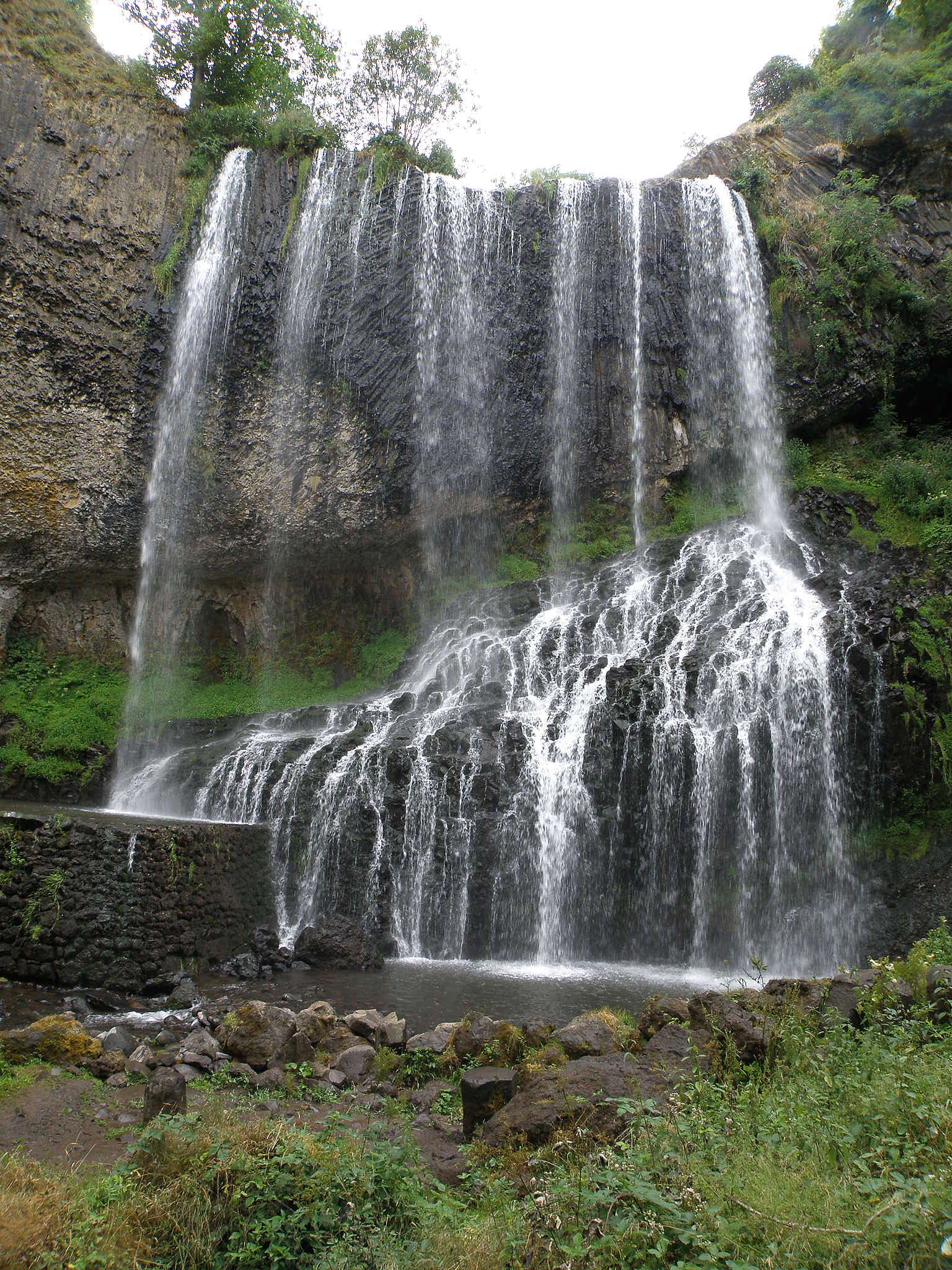
About this place
Cascade de la Beaume is a waterfall tucked away on the boundary between the villages of Solignac-sur-Loire and Le Brignon, in the Haute-Loire department, in the Auvergne-Rhône-Alpes region of France. It sits close to Le Puy-en-Velay and the small hamlet of Agizoux, at an altitude of roughly 900 metres. The site sums up what makes this part of Auvergne distinctive: a volcanic plateau shaped over millennia by flowing water.
Where exactly is the waterfall?
The waterfall lies in wooded terrain near Agizoux, between the villages of Le Brignon and Solignac-sur-Loire. The surrounding plateau is volcanic in origin, built from basalt and marked everywhere by the region's ancient eruptions. Signposted access to the site starts from Solignac-sur-Loire.
How high is it, and where does the water come from?
The waterfall is fed by the Ourzie, a river that has carved its way into the basalt of the plateau over a very long time. At the edge of the cliff, the water drops 27 metres, and it's at the base of this fall that the river takes on a new name: the Beaume, a tributary of the Loire. The rock face behind the falling water exposes basalt columns, the hardened remains of old lava flows, making the geology of the site as much of a draw as the water itself.
How do you get there?
The easiest approach is to park at the Reynardon car park, from which a marked path leads through the forest down to the base of the waterfall. The walk down takes about 20 minutes, so allow roughly 40 minutes for the round trip. A viewpoint named Belvédère Gilles Delherm sits right at the site.
For a longer outing, the PR067 trail is a signposted 10.5-kilometre loop that starts in the village of Solignac-sur-Loire itself. It takes around 2 hours 50 minutes and is rated as a moderate hike. The route crosses the plateau surrounding the village before descending to the waterfall.
What should visitors know before going?
The final stretch down to the waterfall is steep, and it can get slippery in wet weather, so sturdy hiking shoes with good grip are worth bringing. This is a natural site with no built-up facilities, so pack water and dress for the conditions, especially in autumn and winter.
When is the best time to visit?
The season changes the character of the waterfall considerably. In spring, snowmelt from the higher plateau feeds the Ourzie and the falls run at their fullest and most dramatic. In summer, the flow calms down, and the shade of the forest along with the cool air near the falling water make for a pleasant break from the heat. In winter, when temperatures drop low enough, Cascade de la Beaume can partly freeze, turning into an ice cascade.
Where does the name come from?
The name "Beaume" — shared by both the waterfall and the river it feeds — traces back to the Late Latin word "balma," meaning cave. This kind of naming is common across this part of France, where rock shelters and caves have long served as landmarks in the landscape.
Frequently asked questions
How tall is Cascade de la Beaume? The waterfall drops 27 metres from the top of the basalt cliff.
Which river forms the waterfall? The Ourzie river forms the waterfall; below the fall it becomes the Beaume, a tributary of the Loire.
How long does it take to reach the waterfall? From the Reynardon car park, it's about a 20-minute walk down and around 40 minutes for the full round trip. The longer PR067 trail from Solignac-sur-Loire is a 10.5-kilometre loop taking about 2 hours 50 minutes.
Is the walk difficult? The short route from the car park is easy, but the final descent to the waterfall itself is steep and can be slippery, so proper footwear is recommended.
Which commune is the waterfall located in? The waterfall sits on the boundary between the communes of Solignac-sur-Loire and Le Brignon, in the Haute-Loire department.
Nearby places

Earn badges for the places you visit
Download NextOnTrip, discover new places and check off your trails.