Coast in Portugal
A guide to 65 Coast in Portugal — with descriptions, photos and traveler visits from the NextOnTrip community. Locations spread across 44 cities and towns. Most visited by the community: Old Pier of Porto Santo, Praia da Adraga, Guia Lighthouse.
-
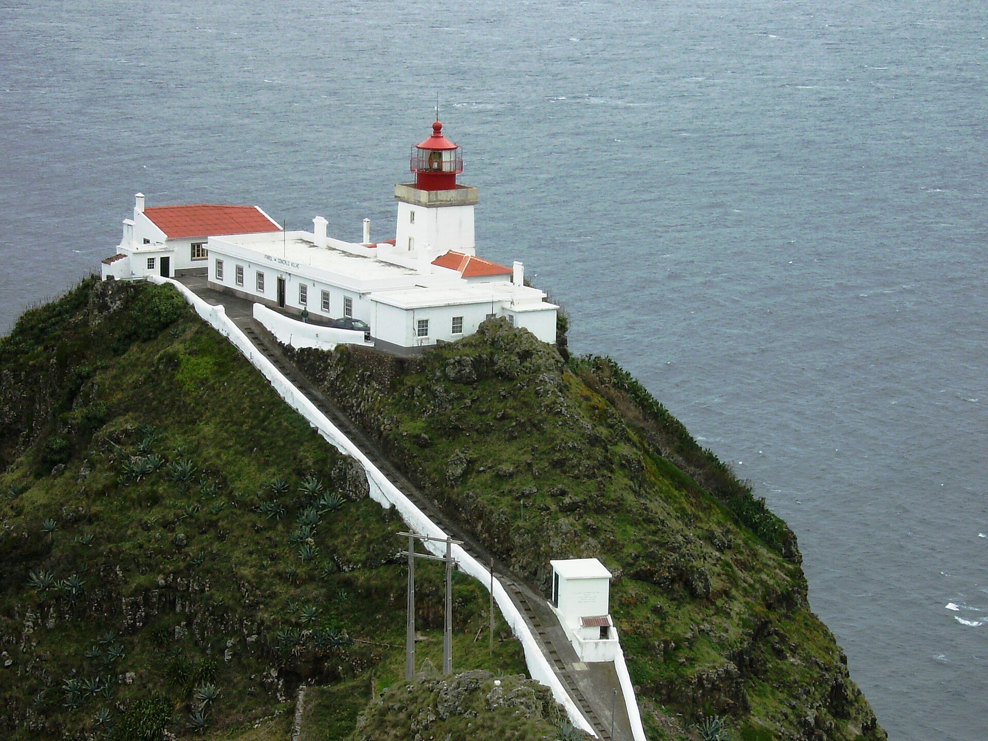
Gonçalo Velho Lighthouse
Santo Espírito
Gonçalo Velho Lighthouse crowns the headland of Ponta do Castelo near Santo Espírito, on the southeastern tip of Santa Maria, the oldest and sunniest island in the Azores. The white-and-red building looks out over the open Atlantic and makes a rewarding stop on a drive around the island's rugged eastern side. What will you see? The lighthouse went into service in 1927. Its masonry tower has a square profile, rises about 14 metres, and carries a lantern with a gallery. A single-storey keeper's house is attached to the base. The walls are white and the lantern is red, so the structure stands out clearly against the green slopes and the sea. The keepers' compound was enlarged in 1934 and again in 1955. Because the tower sits on top of a cliff, the light burns roughly 114 metres above sea level. It shows three white flashes every 13.5 seconds, visible far out to sea after dark. Who was Gonçalo Velho? The name honours Gonçalo Velho Cabral, the Portuguese navigator who spotted the Formigas rocks in 1431 and reached Santa Maria in 1432. The traditional account dates the landing to 15 August, the Feast of the Assumption, which explains the island's name. Historians now credit Diogo de Silves with first sighting the island in 1427. Gonçalo Velho became the island's first captain-donatary, and settlers, many from the Algarve, founded Vila do Porto, the first town in the Azores to receive a royal charter. Can you go inside? The grounds and tower are normally closed. Lighthouse listings say they open on Wednesday afternoons, so plan around that day if you want a closer look, and confirm current hours with the tourist office in Vila do Porto. The headland and its views can be enjoyed at any time. How do you get there? The lighthouse is in the southeast of the island, in the parish of Santo Espírito. A rental car is the easiest option, since public transport on Santa Maria is limited. The island is small, so the drive from Vila do Porto is short. Do not confuse it with the harbour light at the end of the breakwater in Vila do Porto, which is a separate, much smaller tower. When is the best time to visit? Santa Maria is drier and milder than the rest of the archipelago, so summer suits coastal walks. The headland can be windy, so bring a light jacket. Late afternoon is good for photos, when the white tower catches warm light. Frequently asked questions When was Gonçalo Velho Lighthouse built? In 1927. The keeper's buildings were expanded in 1934 and 1955. How tall is it? The tower is about 14 metres, but the light is around 114 metres above the sea thanks to the clifftop site. Can visitors enter? It is usually closed, but listings say it opens on Wednesday afternoons. What is the light signal? Three white flashes every 13.5 seconds.
-
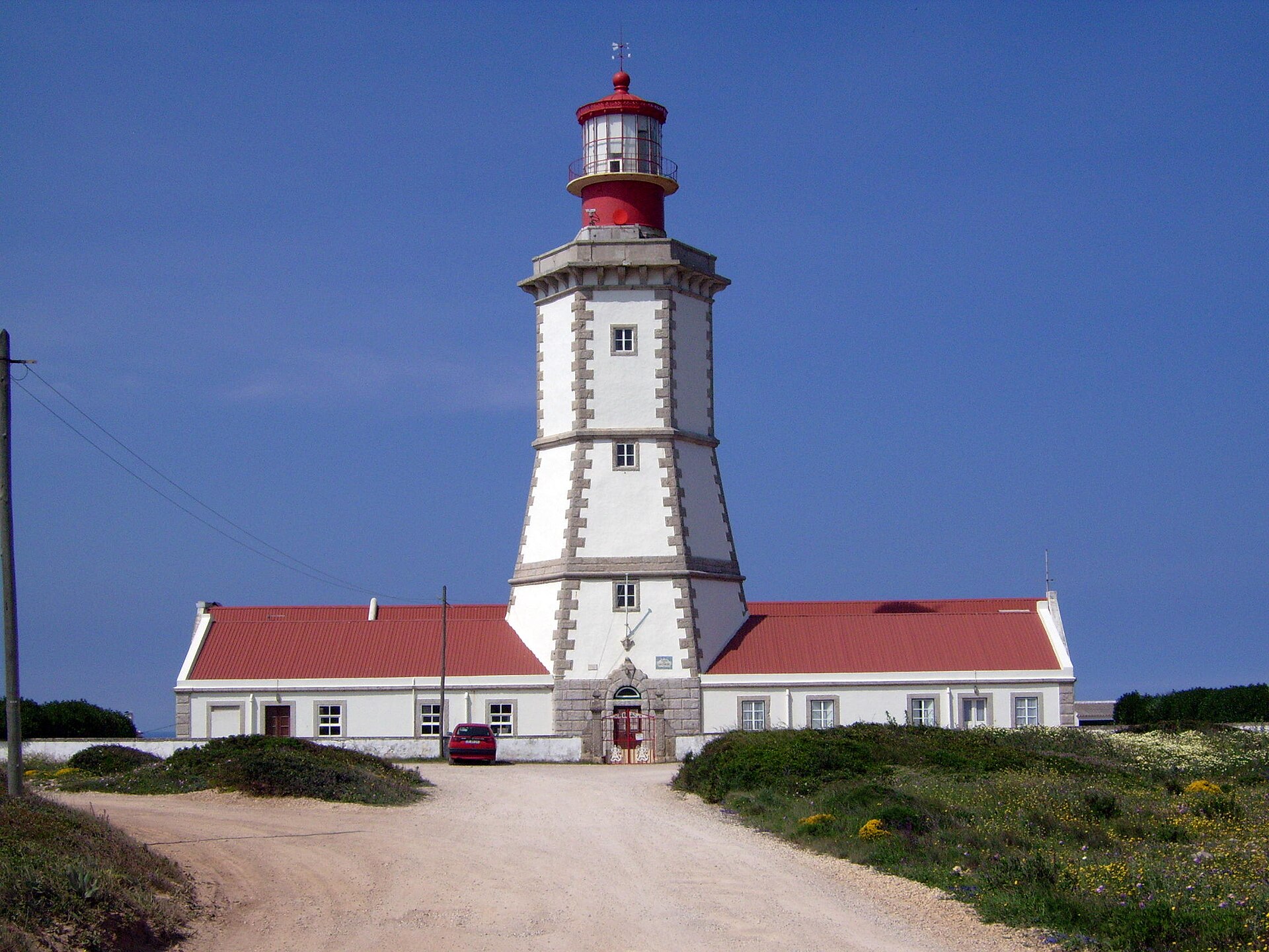
Cabo Espichel Lighthouse
Sesimbra
Cabo Espichel Lighthouse sits at the western tip of the Setúbal peninsula, in the parish of Castelo, municipality of Sesimbra. Built in 1790 on a cliff above the Atlantic, it ranks among the oldest lighthouses in Portugal. What is its history? The present tower dates from the late 18th century, when the Marquis of Pombal had a chain of navigation lights built along the coast. Local Portuguese sources say a modest lamp was already kept here around 1430 by the brotherhood of the nearby sanctuary. The light source changed over time: olive oil first, petroleum vapour from 1886, and electricity from 1926. A fog signal arrived in the late 19th century, first a mechanical bell and later a compressed-air siren. The station was automated in 1989 and still serves shipping. What does it look like? The red-and-white tower is 32 metres tall, and the lamp stands roughly 168 metres above sea level. It shows a white light, three flashes every 12 seconds, visible about 26 nautical miles (around 48 km) away. Visitors who get inside climb 135 stone and 15 iron steps. Low service buildings surround the tower, and the setting gives wide views of sheer cliffs and open ocean. Can you go inside? The Portuguese Navy, which owns the site, has opened selected lighthouses to visitors on set days since 2011. Schedules change, so check with the Navy or the Sesimbra tourist office before you go. Even when the interior is closed, you can walk around the tower and its grounds. How do you get there? The cape is about 15 km from the centre of Sesimbra and roughly 40 km from Lisbon. Driving is the easiest option, using the road along the peninsula to a free parking area at the cape. Public transport is sparse, so a car or a taxi from Sesimbra works best. What else is nearby? Right next door stands the baroque Nossa Senhora do Cabo sanctuary, with long arcaded pilgrim lodgings. Cliff-top paths offer ocean views, and dinosaur footprints preserved in the rock can be found around the cape. When should you visit? Clear late-spring and summer afternoons work best, especially if you stay for sunset. Strong wind is common here, so bring a warm layer even on hot days. Frequently asked questions When was Cabo Espichel Lighthouse built? The current tower dates from 1790. How tall is it? The tower is 32 m high and the light sits about 168 m above sea level. Is it still in use? Yes. It has been automated since 1989 and remains an active navigation aid. Is there an entry fee, and when is it open? The Navy runs interior visits on selected days, so confirm details before your trip. The area around the lighthouse is open to everyone.
-
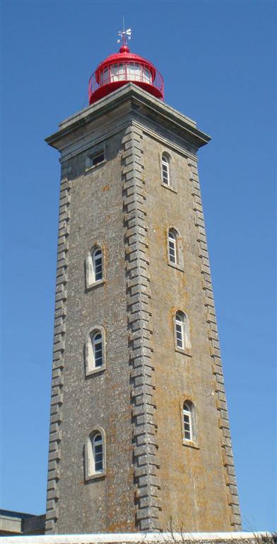
Montedor Lighthouse
Viana do Castelo
Montedor Lighthouse (Farol de Montedor) sits on a headland in the parish of Carreço, in the municipality of Viana do Castelo, northern Portugal. It is the country's northernmost lighthouse, and its beam carries far out over the Atlantic. What is Montedor Lighthouse? The stone tower rises on high ground right above the ocean, a few kilometres from the mouth of the Lima River. It stands about 4 nautical miles north of the Lima estuary and about 7 nautical miles south of the Minho, the river that marks the border with Spain. The tower is roughly 28 metres tall and the lamp sits about 103 metres above sea level. The light reaches 22 nautical miles (around 41 km). It shows white, in a pattern of two flashes every 9.5 seconds, through a third-order Fresnel lens. When was it built? The light was first lit on 20 March 1910. Plans for lighthouses along this coast go back much further: the Marquis of Pombal signed a licence for several of them in 1758, yet Montedor only got its tower more than a century and a half later. A building put up in 1939 housed a radio beacon from 1942, switched off in 2001 once it no longer mattered for navigation. The lighthouse has been automated since 1987. How do you get there? The lighthouse is on the coast north of the city of Viana do Castelo, near Carreço. Driving from Viana is the easiest option. Walkers can use the local trails the municipality has marked around Carreço (routes PR6 and PR7). Check current access rules before you go, because the tower is not open all the time; lighthouses are occasionally opened to visitors during Portuguese Navy Day events. What is there to see nearby? The headland is all about the coastline: cliffs, rocky beaches and open Atlantic. Close by is the Praias Antigas do Alcantilado de Montedor natural monument, a set of ancient beaches preserved in the cliff that geology fans will appreciate. On a clear day you can follow the coast toward the Minho estuary. The ocean wind blows here all year, so bring a warm layer even in summer. When should you visit? Late afternoon gives the best light for photos, with the tower against the evening sky. Summer is the driest and most comfortable season for the trails. In winter the sea can be dramatic, but keep well back from the cliff edge. Frequently asked questions Is it the northernmost lighthouse in Portugal? Yes, Montedor is the most northerly lighthouse in the country. When was it built? It was inaugurated on 20 March 1910. How tall is it? The tower is about 28 metres, with the lamp roughly 103 m above sea level and a range of 22 nautical miles. Can you go inside? Not always. The station is automated and access depends on current rules, so check before visiting.
-
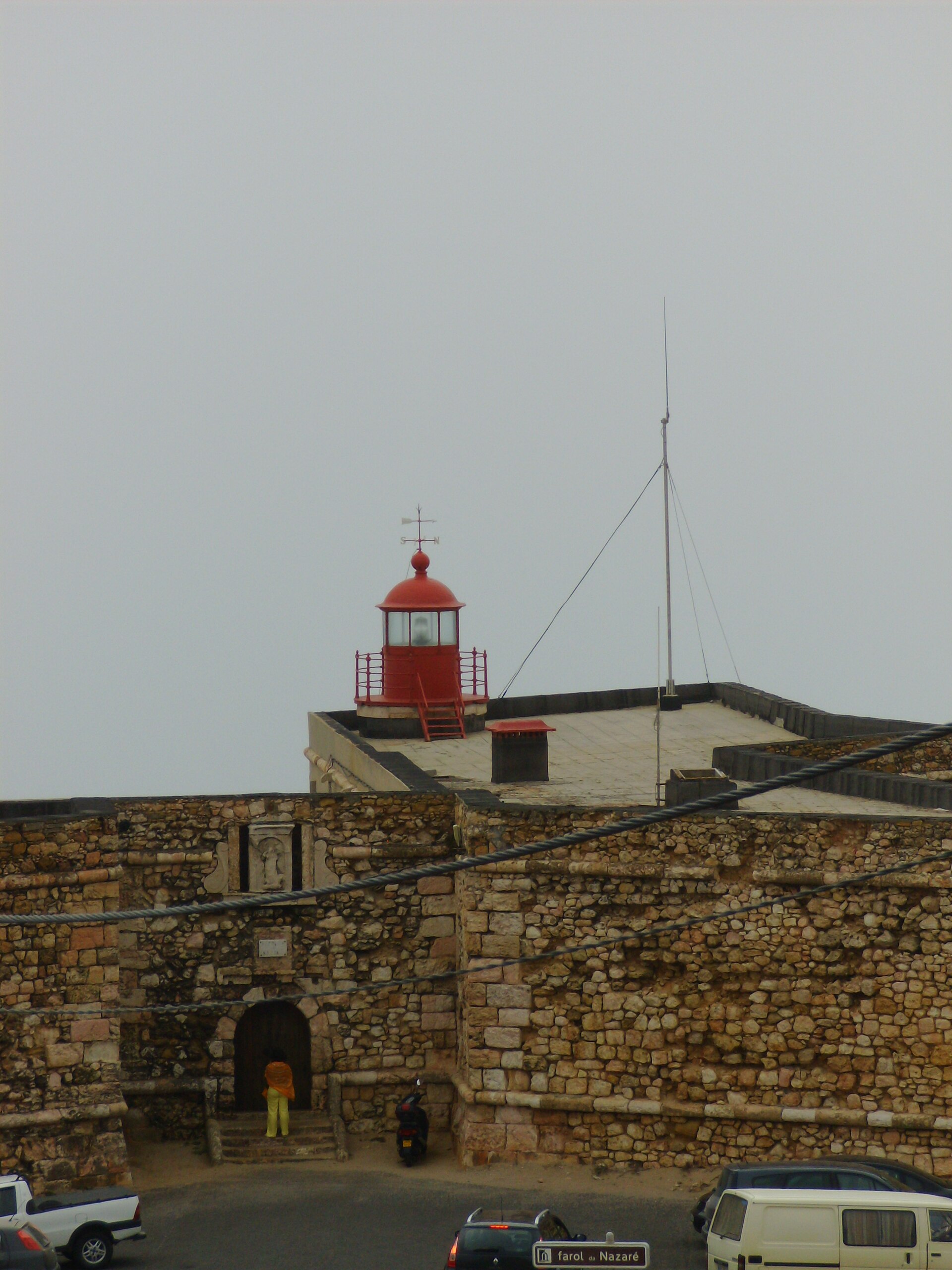
Nazaré Lighthouse
Nazaré
Nazaré Lighthouse (Farol da Nazaré) crowns the headland above the town of Nazaré in Portugal's Oeste region. It is built into the Fort of São Miguel Arcanjo, and from here you look straight down on Praia do Norte, the beach known for some of the biggest surfable waves on Earth. What is this place? Work on the fortress began in 1577, on the tip of the promontory, and it was altered and enlarged several times afterwards. When it was extended in 1644 it was dedicated to the Archangel Michael, a dedication still carved above the doorway. During the first French invasion (1807-1808) Napoleonic troops occupied it, and local people helped push them out, so the site is remembered as a symbol of popular resistance. The lighthouse itself was added in 1903. It remains in service, with a beam visible about 15 nautical miles out and a sound signal for thick fog. What will you see? The fort stands more than 80 metres above sea level, so the view takes in the Atlantic, Praia do Norte and the rooftops of Nazaré. Inside, a small museum covers Nazaré's surfing culture. It also helps explain the waves: an underwater canyon about five kilometres offshore funnels ocean energy toward the coast, and swells here can top 30 metres. How do you get there? The lighthouse sits at the outer end of the headland, north of the town centre. From the main beach promenade it is a walk, and the last part climbs uphill. You can also drive and park nearby, though spaces fill up in high season. If you are already in Sítio, the clifftop district, it is a short stroll. When should you visit? Big-wave days come mostly in autumn and winter, when strong Atlantic storms hit the coast. Spectators gather around the fort then, and the view is at its most dramatic. Summer is calmer, with easier weather for clifftop walks and sunsets. Check museum opening hours with the local tourist office before you go. Frequently asked questions Is the Nazaré lighthouse still working? Yes. The 1903 light still serves shipping, reaching roughly 15 nautical miles. Can you go inside? The fort houses a surfing museum. Entry rules and hours change, so confirm them before your visit. Where is the best place to watch giant waves? The platform by the fort looks down on Praia do Norte. Aim for a day with a heavy storm swell, usually from autumn to spring. Is it far from the centre of Nazaré? No. It is a walk from the promenade, though you will climb a fair slope.
-
Ponta das Lajes Lighthouse
Lajes das Flores
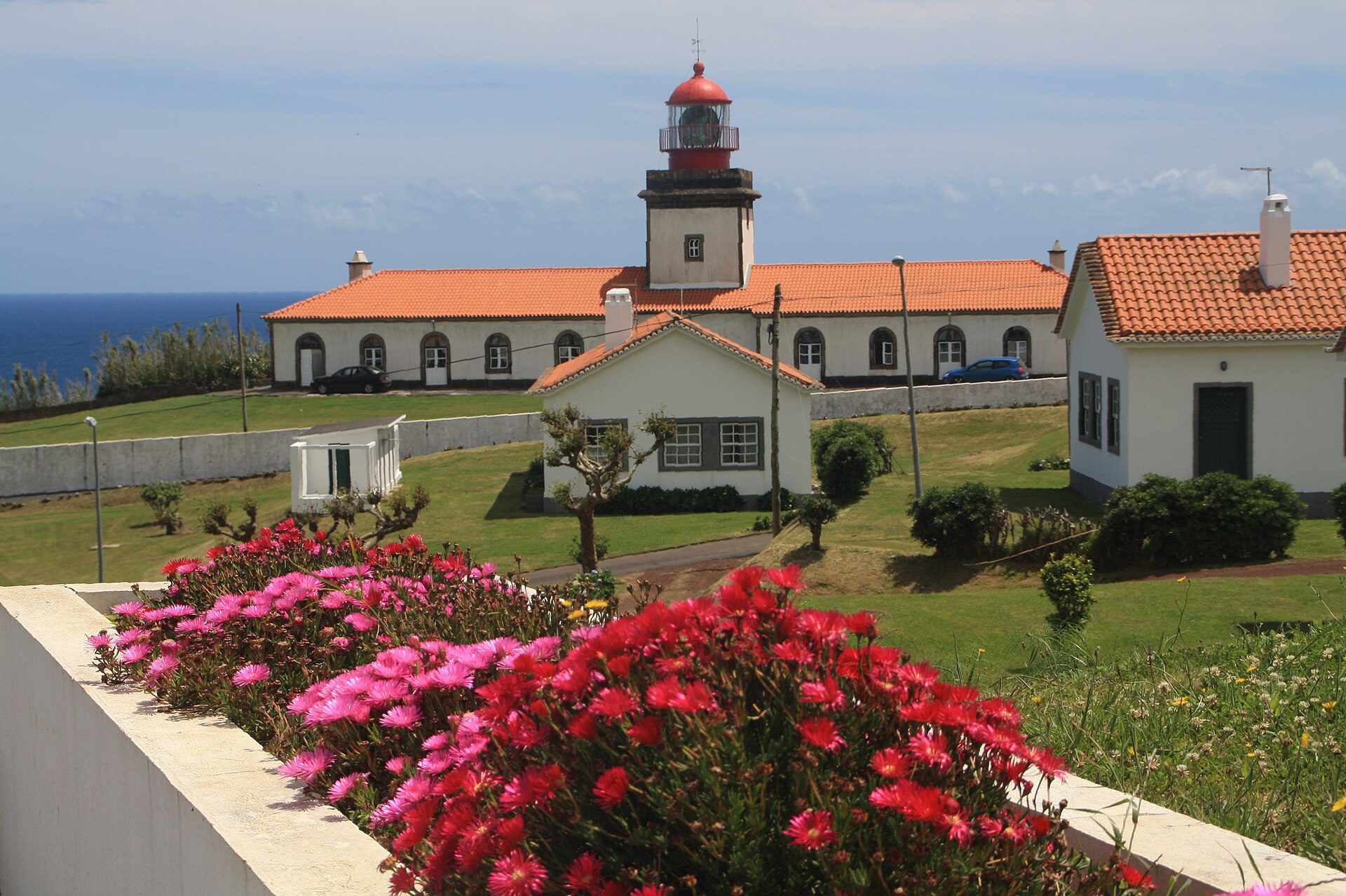
Ponta das Lajes Lighthouse sits on the south-eastern headland of Flores island, in the municipality of Lajes das Flores in the Azores. The white, square tower with a red dome has been in service since 1910 and is among the most powerful navigation lights in the whole archipelago. It makes a rewarding stop for anyone who wants to see the wild Atlantic edge of Europe. What kind of lighthouse is it? The masonry tower stands about 16 metres tall. Its shape is simple: a square plan, white walls and a contrasting red dome over the lantern room. It was fitted from the start with a second-order Fresnel lens, a large multi-ring optic used for lights that must carry far over open water. The station is still an active aid to navigation, so this is a working lighthouse rather than a ruin or a museum. How does the light work? The lighthouse shows a group of three white flashes every 28 seconds, written in navigation charts as Fl(3) W 28s. Its range is roughly 26 nautical miles, close to 48 kilometres. Travel guides rank it as the second most powerful light in the Azores, behind Ponta da Ferraria on São Miguel. That gives it an important role for ships passing the western group of islands. Where is it and how do you get there? The tower stands on the Ponta das Lajes headland in the south-east of the island, close to the town of Lajes das Flores (about 39.376 N, 31.177 W). Lajes das Flores is the municipal seat and one of the island's two main settlements, so it is the natural base: rent a car or use local transport and follow the coastal roads towards the point. Because the lighthouse is a functioning technical site, visitors usually view it from outside. What else is nearby? Flores was discovered in 1452 by Diogo de Teive and his son João. Today it is one of the greenest and quietest islands of the Azores. From Lajes das Flores you can easily combine the lighthouse with a stroll around the harbour, the shoreline and nearby viewpoints. It works well as a one-to-two-hour outing, ideally on a day with good visibility when the ocean stays sharp all the way to the horizon. When should you go? Azorean weather changes quickly, and fog or rain can arrive on Flores in any season. A clear, sunny day gives the best photographs of the white tower against the sea. After dark you can watch the signature sequence of three flashes repeat every half minute. Frequently asked questions When did the Ponta das Lajes lighthouse start operating? In 1910. The present tower dates from that same period and still serves shipping. How tall is the tower? About 16 metres. Its light can be seen from around 26 nautical miles away. Does the lighthouse shine at night? Yes. It gives three white flashes every 28 seconds. Can you go inside? It is an active navigation station, so the main attraction is viewing it from outside, together with the ocean views around the headland.
-
Ponta da Ferraria Lighthouse
Ponta Delgada
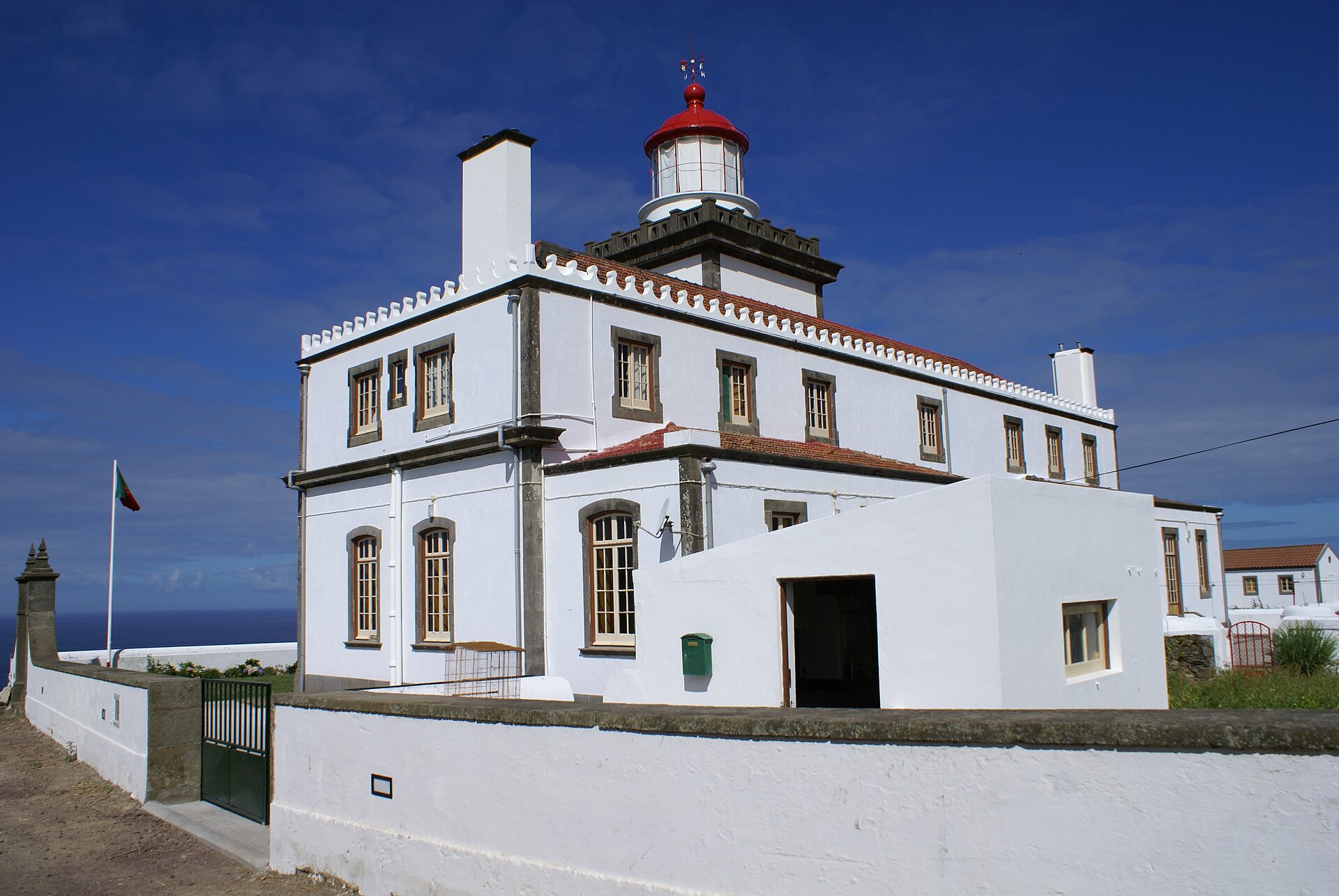
Ponta da Ferraria Lighthouse (Farol da Ferraria) sits on a rugged headland at Ginetes, in the municipality of Ponta Delgada, on the western tip of São Miguel in the Azores. It marks one of the island's westernmost points and doubles as a viewpoint over the Atlantic and the volcanic coast. What will you see at Ponta da Ferraria? The slim tower rises 18 metres above the clifftop. Its light shows three white flashes every 20 seconds and carries 27 nautical miles, guiding ships along the island's northwest coast. From the headland you look out over open ocean, dark lava rock and the geothermal zone below. Right beneath the lighthouse lies Termas da Ferraria, a natural rock pool fed by hot water rising from geothermal vents on the seabed. Ocean swells mix with the heated water, so the temperature shifts with the tide. The pairing of lighthouse and warm sea bath is what draws most visitors here. What is the lighthouse's history? The lighthouse first appeared in a coastal lighting and beaconing plan approved in 1883. Construction took years, and the light entered regular service in November 1901. It began with a constant-level oil lamp, later swapped for a vapour-pressure incandescent burner. Generators electrified it in 1957, and it joined the public grid in 1988. How do you get there? From the city of Ponta Delgada, expect a 25 to 30 minute drive towards Ginetes, then a narrow road down to the coast. The site is about 1.8 km from the centre of Ginetes. Parking at the headland is limited and the road above the spa complex is narrow, so drive slowly. Public transport is poor; a rental car is the practical choice. Can you go inside? The interior opens only occasionally. According to Azores tourism information, the lighthouse admits visitors on summer Wednesday afternoons, and groups of eight or more need permission from the harbour authority on other days. Most visitors are content with the grounds, since the views need no ticket. When should you visit? For a swim, arrive within about two hours of low tide, when water near the vents is warmest and waves stay off the rocks. At high tide the pool is cooler and rougher. Bring water shoes, because the rock is sharp and slippery. Summer gives the best odds of clear skies for sunset over the ocean, yet Azorean weather can change within the hour, so pack a jacket. Frequently asked questions Is entry to Ponta da Ferraria free? The grounds around the lighthouse and the rock pool are open to everyone at no charge. The tower interior opens only at set times. How tall is the lighthouse? The tower is 18 metres high and its light is visible at 27 nautical miles. How long should you plan for a visit? Thirty minutes covers the lighthouse and views. Add one and a half to two hours if you want to bathe in the thermal pool. What is the nearest village? Ginetes, roughly 1.8 km from the Termas da Ferraria complex. Ponta Delgada is about 25 km away.
-
Topo Lighthouse
Calheta
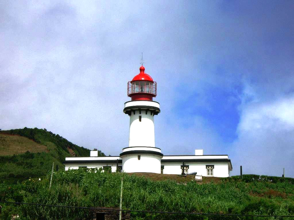
Topo Lighthouse (Farol da Ponta do Topo) marks the south-eastern tip of São Jorge island in the Azores, within the municipality of Calheta. It is a classic Azorean light: a white tower topped with a red lantern roof, attached to the former keeper's house. Where is Topo Lighthouse? The lighthouse stands on Ponta do Topo, roughly 800 metres from the village of Topo (Vila do Topo), part of Calheta municipality. São Jorge is a long, narrow ridge of an island, and Topo sits at its eastern end. The light therefore guards the island's far edge facing the open Atlantic, and on a clear day the view over the ocean is wide. What will you see? The tower is conical, built of reinforced concrete and painted white, with a red roof over the lamp. Residential and service buildings stand beside it. Published heights do not agree: some describe the tower itself (a modest structure of around sixteen metres), while others give the focal height of the light, about 58 metres above sea level. What matters for a visitor is that it rises above a rugged coastline and looks good both from the access road and from the nearby clifftops. When was it built? According to the Azores nature parks authority, the design was the work of engineer José Joaquim Peres and construction was completed in 1925. A lighthouse database lists 1927 as the date the present tower entered service. Think of it as a mid-1920s landmark. The light is automated and remote-controlled, so there is no staff and no tower interior to visit. How do you get there? A rental car is the easiest option on São Jorge. A local road runs from Topo village towards the headland, under a kilometre in total. You can reach the island by air from Terceira or Pico, or by ferry from neighbouring islands. Allow extra time for the drive to the eastern end, because the main road follows the whole length of the ridge. When is the best time to visit? Azorean weather is mild but changeable, and conditions can shift within an hour. Morning or late afternoon with clear skies gives the best views of the lighthouse and the sea. Summer tends to be steadier. Bring a windproof layer, since the headland is usually breezy. What else is nearby? Combine the visit with Topo village itself, home to the historic Solar do Topo. The local harbour has a small piece of history too: in 1877 the Calheta council decided to place a light at the village port, the first on São Jorge. It is not clear whether that was the same structure, so treat it as a note on the harbour rather than on this tower. Frequently asked questions Can you go inside Topo Lighthouse? No. The light is automated and remote-controlled, so you view it from outside. How far is it from Topo village? About 800 metres, a short walk or a quick drive. How tall is the lighthouse? Sources give different figures. The light sits roughly 58 metres above sea level, while the tower itself is much lower. When was it built? Between 1925 and 1927, depending on the source. The engineer José Joaquim Peres designed it.
-
Ponta dos Rosais Lighthouse
Velas
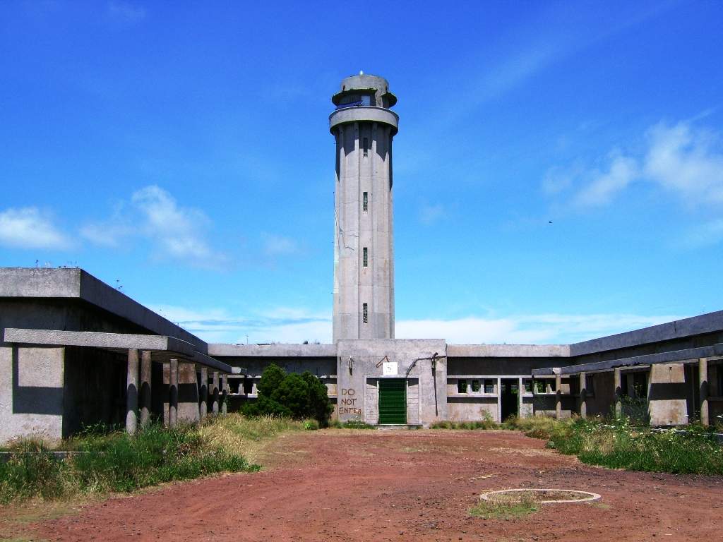
Ponta dos Rosais Lighthouse stands at the far northwestern tip of São Jorge in the Azores, in the municipality of Velas near the hamlet of Rosais. A concrete tower rises above cliffs roughly 200 metres high, and today the site is better known as an atmospheric ruin above the Atlantic than as a staffed station. What is this place? The lighthouse was built in 1958 on one of the island's westernmost headlands. Beside the tower grew a full keepers' compound: an administration and residential block, a motor pool, a communal hearth and concrete wash basins. The tower is about 27 metres tall, and its light sat some 283 metres above sea level, so the beam carried a long way out to sea. Why is it abandoned? Rosais lies in a seismically active zone. In 1964 residents left the area for a time during a series of tremors. Keepers' families still lived here until 1 January 1980, when an earthquake brought down parts of the cliff and the buildings were evacuated. The lighthouse was automated in 1982 and its main lamp replaced with a small solar-powered beacon. The living quarters and service buildings have stood in ruins ever since. What will you see? a concrete tower set against steep cliffs, the crumbling keepers' houses, wash houses and garages, open ocean views to the northwest, classic Azorean scenery: green slopes dropping straight into the sea. Photographers get one of the island's moodiest subjects here, and lighthouse fans see a station shaped as much by geology as by engineering. How do you get there? The lighthouse is in the extreme northwest of São Jorge, in the Rosais area of Velas municipality. Velas is the main town nearby; from there you head west towards Rosais. Take care on the last stretch, since the cliffs are high and the buildings are decayed. When should you go? Azorean weather changes quickly and the wind over the cliffs can be strong. A clear, sunny day gives the best ocean views. The ruins are not secured like a regular visitor attraction, so keep well back from the cliff edge and stay out of cracked buildings. Frequently asked questions Where is Ponta dos Rosais Lighthouse? At the northwestern end of São Jorge island in the Azores, in Velas municipality near Rosais. When was it built? In 1958. The tower is concrete and about 27 metres tall. Is the lighthouse still working? It was automated in 1982 and the main light was swapped for a small solar beacon. The keepers' buildings are ruins. Why were the buildings abandoned? After the 1980 earthquake, parts of the cliff collapsed and the compound was evacuated.
-
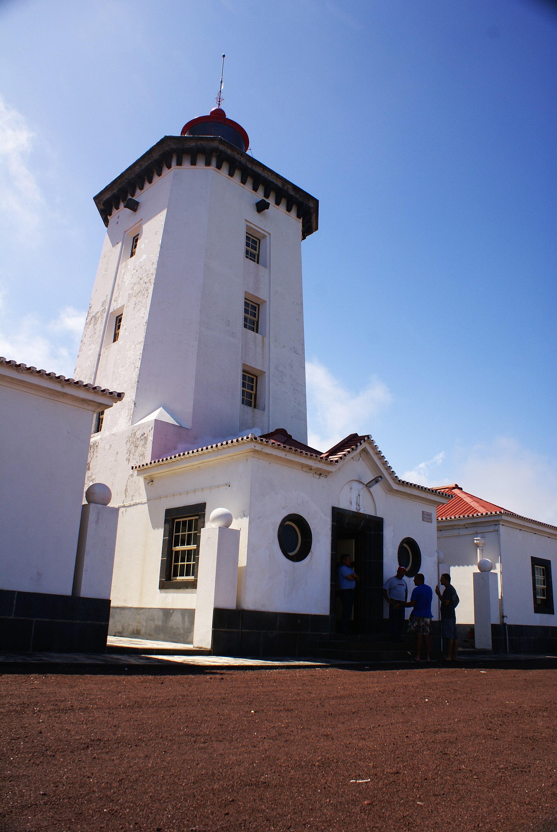
Ponta da Ilha Lighthouse
Lajes do Pico
Ponta da Ilha Lighthouse marks the eastern tip of Pico Island in the Azores, in the municipality of Lajes do Pico. It is one of the youngest lighthouses in the archipelago and still works as an active navigation aid. What kind of lighthouse is it? The tower is a square, white concrete structure topped with a red lantern. It stands roughly 19 metres tall, with the light about 29 metres above sea level. It flashes white three times every 15 seconds and can be seen from 24 nautical miles (around 44 km). When it opened it used a fifth-order Fresnel lens. When was it built? A lighthouse here was first proposed in 1883, yet construction waited until the 20th century. The light came into service in 1946 on land donated by local families. That makes it a modern, plainly functional building compared with the many 19th-century lights elsewhere in the Azores. Where exactly is it? You will find it in the hamlet of Ponta da Ilha, in the parish of Piedade on Pico's east coast. It is the last building on the headland, with open ocean beyond. The coordinates are about 38.412° N, 28.030° W. This is one of the quietest, least built-up corners of the island. What can you see there? This is not a museum. The grounds around the tower are closed to visitors, so you cannot go inside; you admire it from outside. The draw is the setting: a headland with wide views of the Atlantic and, in clear weather, of São Jorge across the channel. The white tower against dark volcanic rock makes a good photo, especially at sunrise when the light comes in from the sea. When should you go? Weather is best from June to September. The eastern end of Pico is often windy, and low cloud can hide the view quickly, so check the forecast before you set out. After dark you can watch the lamp keep its fixed flashing rhythm. Can you combine it with other stops? Yes. Lajes do Pico is known for its whaling heritage and for whale and dolphin watching, and several villages along the southern and eastern coast are close by. The lighthouse fits easily into a drive around Pico, alongside stops in Lajes do Pico and Piedade. Frequently asked questions Can you go inside Ponta da Ilha Lighthouse? No. The lighthouse grounds are off limits to tourists, so it is a view-from-outside stop. When was the lighthouse built? It entered service in 1946, although it was first proposed back in 1883. How far does its light reach? Its range is 24 nautical miles, about 44 km, with three flashes every 15 seconds. Which parish is it in? Piedade, in the municipality of Lajes do Pico, on the eastern shore of Pico Island.
-
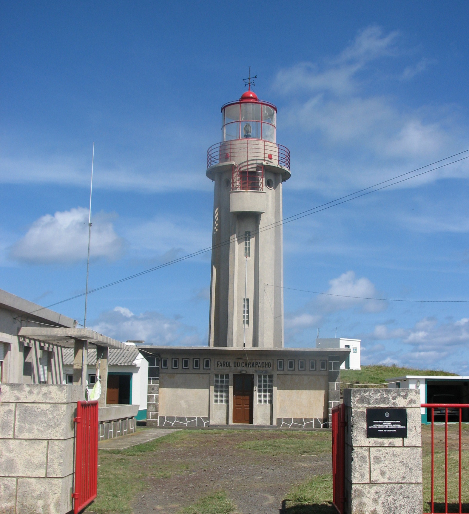
Carapacho Lighthouse
Luz
Carapacho Lighthouse (Farol do Carapacho) stands on the cliffs of Ponta da Restinga, next to the hamlet of Carapacho in the parish of Luz, at the southeastern end of Graciosa in the Azores. It is a modest, working lighthouse, and its real appeal is the high Atlantic cliff it sits on. What is this lighthouse? The tower dates from 1956. It is a cylindrical concrete structure about 14 metres tall, topped by a red lantern dome. The light is located roughly 191 metres above sea level and carries 20 nautical miles, so ships passing the island can see it from far out. The station was automated in 1978 and only joined the island's power grid in 1987. What will you see here? The tower itself is small and nothing like the grand lighthouses of the mainland. You come for the setting: a steep cliff, open ocean and the volcanic coastline of southern Graciosa. It makes a good short photo stop, especially on a clear day. Because it is an active light, treat it as a viewpoint and admire it from outside. How do you get to Carapacho Lighthouse? A rental car or scooter is the easiest option. Graciosa is small, and the drive from Santa Cruz da Graciosa, the island capital, to the parish of Luz takes a few minutes. Follow the signs toward Carapacho and its thermal baths. What else is nearby? The closest attraction is Termas do Carapacho, the thermal spa in the neighbouring hamlet. The springs have been used for centuries; the water contains sulphur, chloride and sodium, and reaches up to about 40°C. It is used for rheumatological conditions. A short stop at the lighthouse followed by a soak makes a natural half-day on the south of the island. Also in this part of Graciosa is Furna do Enxofre, a volcanic cave with a high vaulted ceiling and an underground lake. When should you visit? The lighthouse can be seen all year. Pick a clear time of day for long ocean views, and bring a light jacket, as the cliff can be windy. Summer is also the best season for swimming and walking elsewhere on the island. Frequently asked questions Can you go inside Carapacho Lighthouse? It is an active, automated light, so you view it from the outside, from the surrounding cliff. When was it built? In 1956, and it was automated in 1978. How tall is it? The tower is about 14 metres high, with the light around 191 metres above sea level. What is there to see nearby? The Termas do Carapacho spa in the next hamlet and other volcanic sights in southern Graciosa, such as Furna do Enxofre.
-

Pergola do Molhe
Porto
Pergola do Molhe (Pérgola da Foz) is a neoclassical-style seafront walkway of arched columns in Porto's Foz do Douro district, running beside Praia do Molhe where the Douro meets the Atlantic. It ranks among the most photographed spots on Porto's coast. When was it built and by whom? The structure dates to around 1930, built as part of improvements along Avenida do Brasil. City records name António Enes Baganha as the person in charge of the project, at a cost of roughly 53 thousand escudos. Over the decades the concrete pergola became a Foz landmark and a regular on postcards. What will you see? A covered colonnade facing the ocean and the beach. A concrete balcony and balustrade overlooking waves that hit the breakwater. Ramps down to the sand and cafe terraces around Esplanada do Molhe. Nearby: the Felgueiras lighthouse at the end of the old jetty, and the São Miguel-o-Anjo lighthouse, whose granite tower dates from 1527 and is the oldest surviving lighthouse in Portugal. What changed in the recent renovation? Porto's municipality renovated the pergola in two stages. The first restored the seaside walkway. The second, carried out by the municipal company GO Porto, covered the concrete structure, balcony, railings, walls and the beach access ramps between Jardim dos Ingleses and Esplanada do Molhe. The investment came to about 371 thousand euros. How do you get there? The most atmospheric route is the historic tram line 1, which runs along the river from the São Francisco church to the Passeio Alegre garden. From there it is a short walk toward the sea. You can also walk or cycle the riverside path along the Douro, or take a city bus. When is the best time to visit? Evening. The pergola is a favourite place to watch the sun set over the ocean. In winter and during storms, big waves hit the jetties, so keep away from the edge and avoid wet stretches of concrete. What else is nearby? Continue along the coast after the pergola. The Pontão da Barra do Douro is a 400-metre sea wall protecting the river mouth, while the shorter, older wall ends at the Felgueiras lighthouse. The 16th-century Fortaleza de São João da Foz is close too. A walk of about 5 km links the Fluvial stop near Jardim do Cálem with Homem do Leme beach. Frequently asked questions Is there an entrance fee? No. It is a public municipal promenade, open to walk at any time. How long should I plan? The pergola itself takes a quarter of an hour. With photos, a coffee and a stroll to the lighthouse, allow one to two hours. Can I get down to the beach? Yes, ramps by the pergola lead to Praia do Molhe. Take care when swimming, as waves and currents near the river mouth can be strong. Is it good for sunset? Yes, it is one of Porto's best-known sunset spots, with the light falling directly over the Atlantic.
-
Ribeirinha Lighthouse
Ribeirinha
Ribeirinha Lighthouse (Farol da Ribeirinha) sits on Ponta da Ribeirinha, a headland at the north-eastern end of Faial in the Azores, beside the village of Ribeirinha in the municipality of Horta. Completed in 1919, it is now a half-ruined landmark that most visitors admire from a distance. What is the Ribeirinha Lighthouse? It is a former coastal light that guided shipping around the channel between Faial and neighbouring Pico. The building stands alone on a promontory above the sea, with no other development nearby. Its coordinates are roughly 38.596 N, 28.602 W. What happened to the lighthouse? A strong earthquake on 9 July 1998, of about magnitude 6.2, badly damaged Faial. The lighthouse suffered so much that it was abandoned and has stood in ruins ever since. Close by you will also find the remains of the São Mateus church, dating from 1934, which trail guides mention in the same breath: the village had to cope with the aftermath of the tremors, and some buildings were never rebuilt. What will you see? the abandoned lighthouse against the Atlantic, with Pico across the water, the ruined 1934 church nearby, the raw volcanic scenery of north-eastern Faial. The Ribeirinha area is described as the island's oldest volcanic complex, roughly 800,000 years old. How do you get there? Drive to the village of Ribeirinha and continue towards the headland. The lighthouse is a landmark on the PRC 9 FAI (Ribeirinha) walking route and lies near the Faial Grande Rota (GR 01 FAI). Going right up to the building is not advised: official guides mention access bans, and cattle often graze around the site. View the ruin from a distance and keep to the marked path. When should you visit? Azorean weather changes quickly, so pick a day with good visibility if you want to see Pico across the channel. Bring a windproof layer and sturdy shoes, since the headland is exposed and the ground can be damp. Frequently asked questions When was the Ribeirinha Lighthouse built? In 1919. Is it still in use, and can you go inside? It was abandoned after the 1998 earthquake and is in ruins. Because of access restrictions and the condition of the structure, it is best seen from outside. Which island is it on? Faial, in the north-east near the village of Ribeirinha. Do not confuse it with lighthouses on nearby Pico, or with Vale Formoso, which replaced the destroyed Capelinhos light. Can you walk there? Yes. It lies on the short PRC 9 FAI loop from Ribeirinha and close to the island-circling Grande Rota.
-
Sines Lighthouse
Sines
Sines Lighthouse (Farol de Sines) marks Cabo de Sines, a headland about 1.5 km west of the town centre of Sines in Portugal's Setúbal District. The white cylindrical tower rises roughly 22 metres, and its lamp sits 56 metres above sea level. It is still an active aid to navigation along the Alentejo coast. What does the lighthouse look like? The structure is a two-stage masonry tower topped by a lantern and galleries, painted white. The light gives two white flashes every 15 seconds and carries about 26 nautical miles out to sea. Automation arrived in 1995, so nobody lives on site any more. The setting is a study in contrast: next to the tower you will see the tanks and plant of the port's industrial zone, since Sines is one of Portugal's biggest commercial harbours. When was it built? Planning started in 1866 and construction was finished in April 1880. The first optic was a second-order apparatus fuelled by oil vapour. In 1915 a rotating third-order Fresnel lens replaced it and stretched the range to around 30 nautical miles. The upper stage of the tower was added in 1980. How do you get there? The lighthouse stands on the point at the western edge of town, close to the shore. From the centre of Sines it is a few minutes by car, or about half an hour on foot from the old town. The cape faces the open Atlantic, so expect wind even on calm days in town. The surroundings border industrial land, and access right up to the tower can be limited. Visits inside are offered only on certain days, so check current times with the local tourist office before you go. What else is nearby? Sines is the birthplace of explorer Vasco da Gama. The medieval castle in the centre overlooks the bay and houses a museum, and a statue of the navigator stands in town. Praia Vasco da Gama and Praia de São Torpes are good for swimming and walks, while the wild Costa Vicentina stretches further south. In July the town hosts the Festival Músicas do Mundo, a world-music festival. When is the best time to visit? Early evening works best for photos: the white tower stands out against the sky just as the beam starts to sweep. Summers are dry and sunny, yet the ocean wind blows all year, so bring a light jacket. FAQ Can you go inside the Sines lighthouse? Interior access is occasional and on set dates. Ask the Sines tourist office before your trip. How tall is it? The tower measures around 22 metres, and the light is 56 metres above sea level. When was it built? It was completed in April 1880 and has been in service ever since; it has been automated since 1995. Is the light still working? Yes. It flashes white twice every 15 seconds and serves shipping.
-
Ponta dos Capelinhos Lighthouse
Capelo
Ponta dos Capelinhos Lighthouse stands near the village of Capelo, at the western tip of Faial in the Azores. It is among the most unusual lighthouses in Portugal: a roughly 20-metre octagonal stone tower rising from a black volcanic wasteland, with its lower floors buried under ash. What is the history of the lighthouse? Construction began in April 1894, and the light was first lit in 1903, about 70 metres above sea level. For half a century it guided ships around Faial. The tower sits on top of a two-storey keeper's house. On 27 September 1957 a submarine eruption started just off the coast. It lasted around 13 months, added fresh land to the island and sent so much sand and tuff over the headland that the building was nearly buried. The light was shut down in 1957 and nearby families left their homes. The Capelinhos eruption remains one of the best-documented volcanic events in Azorean history. What can you see here? At the foot of the tower is the Capelinhos Volcano Interpretation Centre, opened in 2008, fifty years after the eruption. Designed by architect Nuno Ribeiro Lopes, it uses the ground-floor rooms of the old lighthouse, now sunk in volcanic sand. The exhibition explains how the eruption unfolded and how it changed life on the island. The visit ends with a climb up the tower. From the top you look over the dark volcanic cone, the cliffs, the Atlantic and the barren, moon-like plain left by the eruption. Expect a fair number of steps. How do you get there and when should you go? The lighthouse sits at the far western point of Faial, a short drive from the island's main town, Horta. A car or taxi is the easiest way, and there is parking on site. A short trail also leads across the volcanic cone and can be extended along the coast. Opening hours of the centre depend on the season: in summer it generally opens daily, in winter some days are shorter or closed, and a full ticket costs about 10 euros. Sources vary on exact times, so check the official Destinazores page before you go. The operator may close the site in bad weather, and the headland is often windy. A clear morning or late afternoon gives the best views. Frequently asked questions Is the lighthouse still working? No. It was shut down in 1957 because of the eruption and now serves as a viewpoint and part of the museum. Can you climb the tower? Yes. The climb is part of the interpretation centre visit, either as a separate fee or within the full ticket. How much time should you plan? Allow 1.5 to 2 hours for the museum and tower, or around 3 hours if you also walk the volcanic cone. Is it suitable for families? Yes, the exhibition is accessible, but the tower has many steps and the coast is windy.
-
Forte da Barra Lighthouse
Gafanha da Nazaré
Forte da Barra Lighthouse in Gafanha da Nazaré is a small navigation light beside a seventeenth-century fort guarding the mouth of the Ria de Aveiro, in the municipality of Ílhavo. It stands on an island next to Ilha da Mó do Meio, and together with the fort it forms one of the oldest defensive points on this stretch of coast. What is this place? Forte da Barra, also called Forte Pombalino, Forte Novo or Castelo da Gafanha, was built between 1642 and 1648 during the Restoration War, when Portugal fought to regain its independence. It was rebuilt in 1801. Over time, silting at the Vouga mouth shifted the shoreline, so the fort lost its military value and by the twentieth century no longer served a defensive role. Today the Port of Aveiro administration manages it, and since 1974 it has held Property of Public Interest status. The light was put up near the fort to help ships find their way around the Vouga mouth. It still serves as a signal for inland navigation. This is not the tall seaside lighthouse most visitors picture. What will you see? a well-preserved bastion fort, with two half-bulwarks joined by a curtain wall (only the southern one was finished), three gun emplacements, a triple arcade with stairs up to the terrace, a cylindrical tower on the terrace, an oversized beacon built from stacked drums. Later buildings are attached to the fort. In recent decades the ground floor worked as a materials store, and the site belongs to a programme to renovate historic buildings for tourism. How is it different from Farol da Barra? The same town has the Farol da Barra, the Aveiro lighthouse opened in 1893 and designed by César de Sousa. At about 62 m it is the tallest in Portugal and stands by Praia da Barra, closer to the present river mouth. The fort light is a separate, far older and humbler structure. Keep the two apart when planning your route. How do you get there? Gafanha da Nazaré lies on the south side of the main channel of the Ria de Aveiro, a few kilometres from Costa Nova and Praia da Barra. It is a drive of roughly fifteen minutes from Aveiro. The site sits at about 40.645 N, 8.733 W. The fort is on port land, so check with the Port of Aveiro whether you can go inside. When should you go? Mornings and the hour before sunset suit it best, when low light brings out the stone and the lagoon surface. Summer brings settled weather, and off-season is quieter, though autumn and winter bring stronger Atlantic wind. Frequently asked questions Is this the same lighthouse as Farol da Barra? No. Farol da Barra dates from 1893 and is a tall lighthouse by the beach. The light at Forte da Barra is a separate, older structure at the fort. When was the fort built? Between 1642 and 1648, and it was rebuilt in 1801. Is the light still in use? Yes, it still serves signalling for inland navigation. Is the fort protected? Yes. It has been classified as a Property of Public Interest since 1974.
-
Regufe Lighthouse
Póvoa de Varzim
Regufe Lighthouse (Farol de Regufe) is a red cast-iron tower on the seafront of the Regufe quarter in Póvoa de Varzim, northern Portugal. Locals treat it as the emblem of the neighbourhood as much as a piece of maritime history. What kind of lighthouse is it? The tower rises about 22 metres. Its cylindrical iron shaft is painted red and stands on a tripod of three iron braces, which gives it an open, skeletal look quite unlike the stone towers found elsewhere on the Portuguese coast. The lamp sat roughly 30 metres above sea level and reached 15 nautical miles. You may also see it called Farol de São Brás. What is its history? Construction took place between 1885 and 1886, and the light was formally inaugurated on 24 March 1892. The designer is not known. The lighthouse worked together with the Farol da Lapa as a leading line: when fishermen saw both lights aligned, they knew they were in the safe channel across a dangerous sandbank in Póvoa Bay. It was restored in 1995, switched off around 2001, and local reports say it was lit again on the evening of 23 April 2015. Why does it matter locally? Regufe is one of the six quarters of Póvoa de Varzim that take part in the São Pedro festivities in June. The lighthouse features in the quarter's imagery and parades, so a visit during the festival gives it a very different atmosphere. It stands near the coordinates 41.374 N, 8.755 W. How do I get there? From the centre of Póvoa de Varzim it is a short walk or drive north along the coast. It pairs well with a stroll on the seafront promenade and the wide town beach. When should I go? The tower is visible from outside all year. Morning or the hour before sunset gives the best photos, when the red ironwork stands out against the sky. Summer brings crowds to the beach, and June is busy with the São Pedro celebrations. Frequently asked questions Is Regufe Lighthouse still working? It was deactivated in the early 2000s, and local sources report it was relit in April 2015. Can I go inside? We found no information on regular interior visits, so plan on admiring it from outside. How tall is it? The tower is about 22 metres tall, with the light at around 30 metres above sea level. Why is it red and open-framed? It is a cast-iron tower on a three-brace tripod, a lighter type of structure than masonry, and the red paint keeps it visible from afar.
-
Douro North Mole Light
Porto
Douro North Mole Light in Porto is a granite harbour light better known in Portuguese as the Farolim de Felgueiras, or Farol do Molhe do Douro. It stands at the tip of the breakwater on the right (north) bank of the Douro, in the Foz do Douro district, right where the river empties into the Atlantic. What is it? The light is a compact hexagonal tower of bare granite masonry in a neoclassical style. It rises about 10 metres, and its lamp sits roughly 17 metres above sea level. A red balcony and red lantern set it apart, and a small whitewashed outbuilding stands beside it. Against the grey stone of the mole and the ocean, those colours make it easy to spot from a distance. Why was the mole built? Sand has long clogged the mouth of the Douro, making the Porto bar a hazardous crossing for ships. Work on a mole along the right bank started in 1790 to steady the river entrance, and similar works followed in 1867. The lighthouse itself went up in 1886, first burning gas with an incandescent mantle and equipped with a fog bell. It was altered in 1916 and 1945, and in 1955 it received a second-order lens with a red light. How does the light work? It shows a red flash every five seconds with a range of about 9 nautical miles (around 17 km). In 1979 it was automated and run remotely from the Leça lighthouse a few miles to the north. The lamp was switched off on 31 March 2009, although the fog signal stayed in service. Because of its historical value, the Portuguese Navy put it back into operation on 13 December 2021. What is there to see nearby? Foz do Douro is Porto's seaside quarter, where river meets ocean. From the mole and its surroundings you can watch waves break on the stone blocks, look across the river mouth to the opposite bank and take in the open Atlantic. It is a favourite spot for a sunset walk, when the red lamp stands out against the sky. The light is a popular photo subject too, and in 2024 the band Khruangbin named a track on the album "A La Sala" after it. When should you visit? Pick a day with clear visibility, ideally late afternoon when the light is soft and the sea turns golden. In strong wind and heavy swell the breakwater area can be dangerous, so in rough weather watch the ocean from a safe distance from the edge. Frequently asked questions Where exactly is the lighthouse? At the end of the north breakwater at the Douro mouth, in the Foz do Douro parish of Porto, on the river's right bank. Is the light still working? Yes. It was deactivated in 2009, but the Navy brought it back into service in December 2021. How tall is the tower? The tower measures about 10 metres, with the light at a focal height of about 17 metres. Can you go inside? We found no information about interior visits; the lighthouse is admired from outside, from around the mole.
-
Santa Marta Lighthouse
Cascais
Santa Marta Lighthouse (Farol de Santa Marta) stands in Cascais, just south of the town centre, where the Tagus estuary meets the Atlantic. A white tower with blue horizontal bands and a red lantern, it is one of the most photographed spots along the seafront. A lighthouse museum sits right beside it. What is this lighthouse? The tower is a square-section masonry structure clad in white tiles. It rises about 20 m, with the light about 25 m above sea level, and the beam reaches roughly 18 nautical miles (over 30 km). It lights up Cascais Bay and guides boats into the town's new marina. The site is the former Santa Marta Fort, a 17th-century defence built to guard the approach to Cascais from the sea. A small light tower with a red lamp went up in 1868 (some sources give an earlier date), a fog signal followed in 1949, and automation in the early 1980s ended the need for a resident keeper. What can you see here? The former keepers' houses hold the Santa Marta Lighthouse Museum, which opened in July 2007. It was set up jointly by Cascais council and the Portuguese Navy. Two exhibition rooms and an auditorium explain how lighthouses work and tell the story of this stretch of coast. Outside, a terrace looking over the bay can be enjoyed without entering the museum. How do you get there? The lighthouse is on the seafront promenade, a 10-15 minute walk from Cascais railway station and the old town. Trains for Cascais leave Lisbon's Cais do Sodré station and take about 40 minutes. The nearest beach is Praia de Santa Marta. When should you go? The terrace and surroundings are best on a clear day or around sunset, when the bay and cliffs catch the light. Museum opening hours and tower-visit arrangements have changed over the years and sources differ, so check the current details with Cascais council before you go. Frequently asked questions Can you visit the museum? Yes, it occupies the former keepers' houses. Check opening times and ticket price with Cascais council or by phone before visiting. Can you climb the tower? Tower climbs have been offered on occasion, for example during museum events. It is not a regular attraction, so ask ahead. How tall is the lighthouse? The tower is about 20 m high, with the light about 25 m above sea level. Is the lighthouse still working? Yes. It still serves shipping in Cascais Bay and at the marina entrance, but it has been automated since the 1980s.
-
Ponta do Albernaz Lighthouse
Ponta Delgada
Ponta do Albernaz Lighthouse sits on a cliff at the far western edge of the Azores, beside the village of Ponta Delgada on Flores island (municipality of Santa Cruz das Flores). It has nothing to do with the city of Ponta Delgada on São Miguel – the two places are hundreds of kilometres apart. The site lies at roughly 39.52° N, 31.24° W. What is it? A white masonry tower with a red dome and a small service building stands on a headland high above the sea. The idea goes back to Portugal's 1883 general plan for coastal lighting and buoyage, and a 1902 commission pushed for a modern lighthouse here. A Flores trail guide gives 1925 as the opening year, while other publications list different construction dates, so the trail guide's year is the safest one to quote. The lighthouse is among the westernmost landmarks in the archipelago and one of the best-known sights of northern Flores. As of 2005 it was reportedly the only lighthouse in Portugal not connected to the power grid, which says a lot about how remote the spot is. What can you see from the headland? The view is the main reward. To the right of the lighthouse, on a clear day, the neighbouring island of Corvo appears on the horizon. To the left lie the Monchique islet – the westernmost point of the Azores and of Portugal – and the fajãs, green ledges of lava at the foot of the cliffs. The village itself has quiet lanes, a church and ocean views, so a short walk around it fits well with the visit. How do you get there? You reach the lighthouse on foot. Trail PR1 FLO, "Ponta Delgada – Fajã Grande", starts in the centre of the village and runs out to Ponta do Albernaz before continuing along the coast towards Fajã Grande. The stretch to the lighthouse is short but rugged: slopes are steep and the path passes close to the cliff edge. The trail guide warns that it is not suitable for anyone with a fear of heights. To reach Ponta Delgada on Flores, drive from Santa Cruz das Flores, where the island's airport is, or from other villages. Public transport is limited, so a rental car or taxi is the most practical choice. When should you go? Weather on Flores changes fast, and wind on the exposed headland can be strong. Views, Corvo included, are best on days without low cloud, typically from late spring to early autumn. Bring a windproof layer, shoes with good grip and water, since there are no services along the way. Evening light over the Atlantic is especially photogenic, but plan your walk back before dark. Can you go inside? Treat it as a viewpoint rather than an attraction with a visit. Sources describe its status differently – some say it was switched off in the 1980s, others that it operates – so do not count on seeing the interior. What you come for is the lighthouse against the cliffs and the ocean, and the panorama around it. FAQ Is Ponta do Albernaz Lighthouse on São Miguel? No. It is on Flores, in the village of Ponta Delgada in the municipality of Santa Cruz das Flores. How long is the walk to the lighthouse? From the village centre it is a short walk, but the terrain is steep, so leave extra time for photos and breaks. Is the route safe for children? The path runs near the cliff edge, so children need constant supervision, and anyone uneasy with heights may prefer to enjoy the view from the village. What else is worth seeing nearby? Along the trail towards Fajã Grande you will find waterfalls, fajãs and the village of Fajã Grande, and from the headland you can see Corvo and the Monchique islet.
-
Bugio Lighthouse
Paço de Arcos
Bugio Lighthouse (Farol do Bugio), in the municipality of Oeiras near Paço de Arcos, rises from a sandbank in the middle of the Tagus estuary, roughly ten kilometres west of central Lisbon. A round tower set inside a stone fort, it once guarded the sea approach to the capital and still works as an active lighthouse. Why was a fort built in the middle of the river? Pirate raids in the mid-1500s showed how exposed Lisbon's coast was. The crown responded with a chain of defences, and the Fort of São Lourenço do Bugio was meant to cross its fire with the fortress of São Julião da Barra on the opposite shore. The idea is credited to the architect Francisco de Holanda. Building on shifting sand was slow: work began in the 16th century and finished in the 17th, under King João IV. Sources disagree on exact dates. What does it look like? The central tower is circular with two levels, and its walls have plain openings. By day it served as a lookout, by night as a navigation light. A light was already burning here by 1693, fuelled by olive oil. The 1755 earthquake wrecked the structure, and the Marquis of Pombal ordered it rebuilt with a new light. Over time it lost its military role. First known as the Tower of São Lourenço da Cabeça Seca, then simply the Fort of São Lourenço, it took the name Farol do Bugio in the mid-20th century after being disarmed. Between 1997 and 2001 the masonry and walls were reinforced, and a circular breakwater and a new landing quay were added. The building is listed as cultural heritage of public interest. How can you see Bugio? There is no regular access to the island, so you cannot simply walk or sail over on your own. From the shore, the seafront promenades at Oeiras and Paço de Arcos, and the Cascais railway line, give good views. For a closer look you need a boat trip: from Oeiras Marina, about 30 minutes, circling the fort without landing; from Cascais Marina, about 40 minutes each way; some operators offer interior visits, with schedules that vary by weather and organiser. When is the best time to go? Boat trips depend on sea conditions, so aim for calm days, ideally from late spring to early autumn. In the evening the tower is especially photogenic against the sunset over the estuary. Frequently asked questions Can you go inside Bugio Lighthouse? Not independently. Access is restricted, and landing is possible only on organised trips that include it. Is the lighthouse still in use? Yes. It continues to serve shipping at the mouth of the Tagus, although its defensive role ended long ago. Where is the best place to photograph it from land? The promenades at Oeiras and Paço de Arcos, where the tower stands out against the water and the far shore. How long is the boat trip from Oeiras? About 30 minutes. Check the current schedule with the operator before you go.
-
Penedo da Saudade Lighthouse
Marinha Grande
Penedo da Saudade Lighthouse rises above the Atlantic cliffs of São Pedro de Moel, a seaside village in the municipality of Marinha Grande, District of Leiria. The white tower is one of the key navigation lights on Portugal's central coast and makes an easy stop on a drive along the Silver Coast. What is the story behind it? The light has been in service since 1912. Portuguese broadcaster RTP dates its start to February of that year, and notes it was switched off between 1916 and 1919 during the First World War. The name comes from the rock it stands on: "penedo" means a crag, and "saudade" is the Portuguese word for longing. A local legend links it to the Duchess of Caminha, said to have mourned her husband here. The tower is about 32 metres tall and the lamp sits roughly 55 metres above sea level. It shows two white flashes every 15 seconds, visible up to 30 nautical miles out. It has been automated since 1980. When the new Cabo Mondego lighthouse opened in 1922, its optic came from Penedo da Saudade. How do you get there? The lighthouse stands on the edge of São Pedro de Moel, at about 39.764 N, 9.031 W. The village is roughly 12 km from central Marinha Grande, and you can drive here from Leiria in under half an hour. Parking in the centre fills up in summer, so arrive in the morning. The tower also appears on the coastal walking and cycling route described by the Marinha Grande council in its "Rota de São Pedro ao Samouco" leaflet. What will you see? cliffs and the wide beach of São Pedro de Moel, the dark green Pinhal de Leiria, the old royal pine forest that runs almost to the shoreline, the slim white tower, easy to spot from the promenade and cliff paths, sunsets over open ocean. The station is run by the Autoridade Marítima Nacional, so going inside depends on current arrangements. The viewpoints outside are open at any time. When is the best time to visit? Late afternoon works best: the sun lights the tower from the west, and after dusk you can watch the beam at work. Summer brings beachgoers and settled weather. Outside the season it is quiet but windy off the ocean, so bring a warm layer. Frequently asked questions Can you climb Penedo da Saudade Lighthouse? The Autoridade Marítima Nacional manages it, and tower access is offered only occasionally. Check the current rules with the operator before you travel. How tall is it? The tower measures about 32 metres, and the light burns about 55 metres above sea level. When did it start operating? In 1912. It was dark from 1916 to 1919 and has run automatically since 1980. What else is nearby? São Pedro de Moel beach, the Pinhal de Leiria forest and Marinha Grande, known for its glassmaking tradition.
-
Ponta Garca Lighthouse
Vila Franca do Campo
Ponta Garça Lighthouse (Farol da Ponta Garça) sits on the cliffs of southern São Miguel, in the parish of Ponta Garça, part of the municipality of Vila Franca do Campo in the Azores. It is a working aid to navigation run by the Portuguese Navy rather than a museum, so people come mostly for the clifftop setting and the Atlantic outlook. What is this lighthouse? The station was built in 1956–1957 by the Comissão Administrativa das Novas Instalações para a Marinha, on a spot in Ponta Garça known as Cinzeiro. The tower is a 14-metre cylinder of concrete, capped with a glass lantern room. A keeper's house and several outbuildings stand beside it. The light is placed about 101 metres above sea level and reaches 13 to 16 nautical miles depending on the colour. Its signature is a green flash every four seconds. In September 1980 the original acetylene gas lighting was replaced by an electric system. How do you get there? Ponta Garça lies along the main road linking Lagoa and Ponta Delgada with the eastern half of the island. Vila Franca do Campo is close by, and Ponta Delgada, the island capital, is a short drive away. A rental car is the practical choice, since buses on São Miguel are infrequent. The lighthouse is at roughly 37.714 N, 25.370 W. What can you see nearby? The draw is the height: from the cliffs around the lighthouse you look out over open ocean and a stretch of coast, with a long horizon on clear days. The tower itself is plain and functional, but it photographs well near sunset. A heron appears on the parish coat of arms, and the name Ponta Garça is often rendered as "heron's point". The lighthouse is not usually run as a ticketed attraction. Treat it as a stop on a south-coast drive, for example combined with a visit to Vila Franca do Campo and its islet. When should you go? Clear afternoons and evenings give the best visibility. Azorean weather can change quickly, so check the forecast before setting out. Summer is the driest season and the light suits photography. Frequently asked questions Is Ponta Garça Lighthouse still active? Yes. It is an operating coastal light managed by the Marinha de Portugal. When was it built? Between 1956 and 1957. It ran on acetylene gas at first and was switched to electricity in 1980. How tall is it? The tower is 14 metres high, and the light shines from about 101 metres above sea level. Can you climb the tower? It is an operational facility, so climbing it is not a standard visitor activity. Check current access locally, for instance with the Vila Franca do Campo municipality.
-
Cabo da Roca Lighthouse
Colares
Cabo da Roca Lighthouse stands in Colares, in the municipality of Sintra, on the cape that marks the westernmost point of mainland Europe. It is the most westerly lighthouse and structure on the continental mainland, and among the oldest lights still working on the Portuguese coast. What is the history of the lighthouse? A royal charter dated 1 February 1758, issued under the Marquis of Pombal, ordered its construction, and the light was first lit in 1772. It was designed as a lighthouse from the ground up rather than fitted onto an existing tower or fort, which makes it Portugal's first purpose-built one. The original lamp reached barely two nautical miles. In 1843 a rotating apparatus with sixteen Argand lamps and parabolic reflectors replaced it. Electric lighting came into use by 1897, and the station was automated in 1990. Sources disagree on its exact rank among the country's oldest lighthouses. It is usually called the second or third oldest still in operation. What does it look like today? The tower is 22 m tall, and the lamp sits about 165 m above the Atlantic on top of the cliffs. Its range is 26 nautical miles, roughly 48 km. It remains an active aid to ships approaching the Lisbon coast. What can you see at the cape? A path from the car park leads to a stone monument topped with a cross, carved with Camões' line about the place where the land ends and the sea begins. From the cliff edge you look out over the ocean and along the coast of the Sintra-Cascais Natural Park. A nearby tourist office sells a certificate confirming that you stood at the westernmost point of the continent. Can you go inside the lighthouse? Parques de Sintra, which manages the heritage sites in the area, sells a paid panoramic visit at the lighthouse. Check its booking system for current slots, as availability depends on the season. How do you get there? Bus 403 runs towards Cabo da Roca from Sintra and Cascais. By car, approach through Colares or from the Cascais side. There is a car park at the cape, but it fills up quickly in high season. When should you go? Come early in the morning or shortly before sunset, when crowds are thinner. The cliffs are windy and sea fog rolls in often, so bring a windproof layer. Frequently asked questions Is Cabo da Roca really the westernmost point of Europe? Yes, of continental Europe. Islands such as the Azores lie farther west. How tall is the lighthouse? The tower is 22 m tall, and the light is 165 m above sea level. Since when has it been lit? Since 1772. It still operates, fully automated since 1990. Do you pay to visit the cape? The viewpoint by the monument needs no ticket. The panoramic lighthouse visit and the certificate are paid.
-
Ponta da Piedade Lighthouse
Lagos
Ponta da Piedade Lighthouse sits on the headland of the same name in Lagos, on Portugal's Algarve coast. It has guided ships into the Bay of Lagos since mid-1913, and it marks the gateway to some of the most photographed sea cliffs in southern Portugal. What kind of lighthouse is it? The tower is built of masonry and stone, with the former keeper's house attached. Its light is 51 m above sea level and has a nominal range of 20 nautical miles. It shows a single white flash every 7 seconds through a fourth-order Fresnel lens. The station was automated in 1983, so no keeper lives on site any more. Can you go inside? No. The lighthouse is closed to visitors and is seen from outside only. The surrounding headland is open with no gate, ticket or opening hours, and the walkways around it give broad views of orange rock, open sea and the Lagos bay. What is there to see around it? Golden-orange sandstone cliffs rise from the water here, carved by waves into arches, stacks and narrow channels. Several viewpoints sit along the cliff edge. The sea caves can only be explored from the water, by small boat or kayak. How do you get to Ponta da Piedade? The headland is roughly 2-3 km from central Lagos. You can walk the coastal route, cycle or drive. A free car park sits near the lighthouse, but it fills early in summer, especially between 10:00 and 15:00. Arrive in the morning or late afternoon. How do you reach the caves? Stone steps lead from the main viewing platform down to a small cove at water level. Sources disagree on the count, from a little over a hundred to about two hundred, depending on the starting point. Small boats leave from the cove, and larger tour boats depart from the Lagos marina. Prices change each season, so check on the spot. When is the best time to visit? Sunrise and sunset give the richest colour on the cliffs and fewer people. July and August are the busiest months. Frequently asked questions Is there an entrance fee for the lighthouse? Entry to the headland is free, and the lighthouse itself is not open to the public. You only pay for boat or kayak trips. When did the lighthouse start operating? It began operating in mid-1913 and was automated in 1983. How long should I plan for a visit? An hour covers the viewpoints. Adding a boat trip to the caves usually takes two to three hours including the walk. Is the descent to the water difficult? It is a stone staircase with no lift, so some fitness is needed. If mobility is limited, the views from the top are enough.
Earn badges for the places you visit
Download NextOnTrip, discover new places and check off your trails.