Town in Croatia
A guide to 12 Town in Croatia — with descriptions, photos and traveler visits from the NextOnTrip community. Locations spread across 12 cities and towns. Most visited by the community: Gmina Marija Gorica, Rakovica, Gmina Bistra (Chorwacja).
-
Bol
Bol
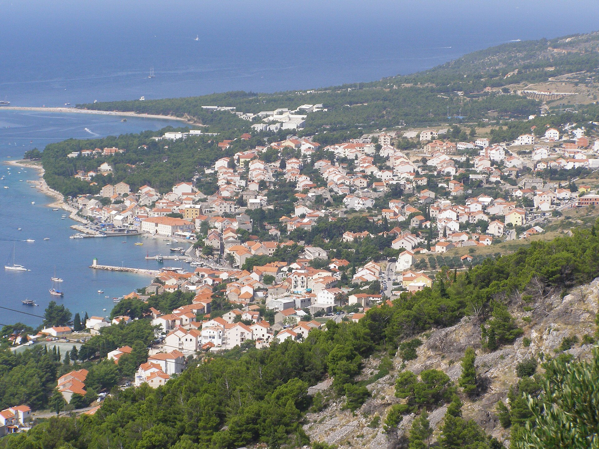
Bol is a municipality and small town in Croatia on the south coast of the island of Brač in central Dalmatia. It is best known for Zlatni Rat beach and its Dominican monastery, and it ranks among the island's most visited places. What to see in Bol What is Zlatni Rat? West of the town lies Zlatni Rat, one of the best-known beaches on the Adriatic and a symbol of the area. It is a spit of pebbles almost half a kilometre long, shaped by winds and sea currents, so its outline shifts over time. It is the most famous beach not only in Bol but on all of Brač. How do you get to Zlatni Rat? Taxi boats run to the beach from Bol's old harbour. You can also walk, which takes about 20 minutes. In summer the beach can get very busy, so if you prefer calm, consider going earlier in the day or outside peak season. The Dominican monastery At the eastern end of Bol, on the Glavica peninsula, stands the Dominican monastery. One source dates it to the fifteenth century. Inside is a museum, and among its treasures is a rare altarpiece attributed to the Italian master Tintoretto. Quieter beaches Near the monastery is a beach split into two sections, Kotlina and Bijela Kuća, regarded as less crowded than Zlatni Rat. Martinica beach, also close to the monastery, is another calmer option. The town centre and harbour Around the harbour you will find a Baroque summer residence, a loggia with a small chapel, a Renaissance-Baroque palace with an art gallery, the parish church, a small square and the Kaštil fortress. Together they make a compact area that is easy to explore on foot. Activities and views From Vidova Gora, the highest peak of all the Dalmatian islands, you get views across the islands of central Dalmatia. The area around Bol also offers water sports, hiking and a chance to explore the island's natural scenery. Frequently asked questions What is Bol famous for? Mainly for Zlatni Rat, a beach almost half a kilometre long, and for the Dominican monastery with its museum. Can you walk to Zlatni Rat? Yes, the walk from the centre takes around 20 minutes. Taxi boats from the harbour are the alternative. When is it least crowded? In summer the beaches, especially Zlatni Rat, can be packed. You will find fewer people outside peak season and at nearby Kotlina, Bijela Kuća and Martinica. What is there to do besides the beaches? Visit the Dominican monastery and its museum, see the historic buildings around the harbour including the Kaštil fortress, enjoy the views from Vidova Gora, or hike in the surroundings. Are water sports available? Yes, the area offers water sports as well as hiking. Bol suits travellers who want to combine beach time with light sightseeing and a trip into the hills, all on the same island.
-
Metković
Metković
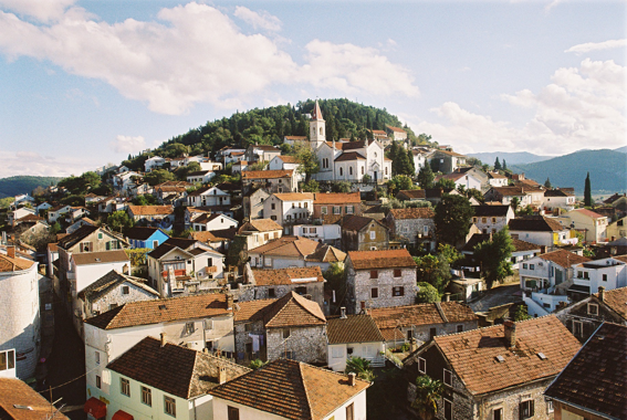
Metković is a town in southern Croatia, in Dubrovnik-Neretva County, set on the banks of the Neretva River close to the border with Bosnia and Herzegovina. The 2011 census counted just over 15,000 residents, making it the largest settlement of the lower Neretva valley. For travelers it is a practical base for exploring the delta, away from the crowded coast. Where is Metković and what defines it? The town sits in the southeast of the country, and the river shapes everything around it. It once decided the town's trade; today it defines the landscape, farming and tourism. The Neretva valley is known for fertile fields, channels and wetlands, and Metković serves as its gateway from the inland side. What is the history of Metković? The settlement is first recorded in a court document from 1422, when it was a small farming and cattle-raising place. In the 19th century it grew into a trading centre, since the river carried goods inland. One curiosity from that era: Hotel Austria opened here in 1890, considered one of the first hotels on the Adriatic. What can you see nearby? Narona in Vid – the archaeological site of a Roman colony a few kilometers from town. Remains of the Augusteum, a temple devoted to the imperial cult, survive together with sculptures of emperors. The archaeological museum holds around 900 finds, and traces of early Christian basilicas can be seen on the grounds. Ornithological collection – assembled through the efforts of ornithologist Dragutin Rucner, it is regarded as one of the larger collections in Europe and focuses on the birds of the Neretva delta. Vratar fortress – an old stronghold rising to the northwest of the town, symbolically guarding the entrance to the valley. Monument to Fr. Ante Gabrić – a missionary born in Metković who worked in India and collaborated with Mother Teresa. Are there events in Metković? Yes. The best known is the Maraton lađa, a traditional race of long Neretva boats. Around 30 crews from the valley and abroad take part, and it is held on the second Saturday of August. Check the date before traveling, as organizers can adjust it. How to spend your time here Boat trips through the delta's channels and backwaters are popular, offering bird watching and a look at the traditional river landscape. The town works well as a stop on the route between Dubrovnik and Split, or as a starting point for excursions deeper into the valley. Frequently asked questions Where is Metković? In southeastern Croatia, on the Neretva River, near the border with Bosnia and Herzegovina. How many people live in Metković? Just over 15,000 at the 2011 census. What is Narona? A Roman archaeological site in nearby Vid, with the remains of the Augusteum and a museum displaying finds. When is the Maraton lađa? Traditionally on the second Saturday of August; confirm the current date before your trip. Is it a good place for a short stop? Yes, especially for those interested in archaeology, birdlife and boat trips around the river delta.
-
Konavle
Cavtat
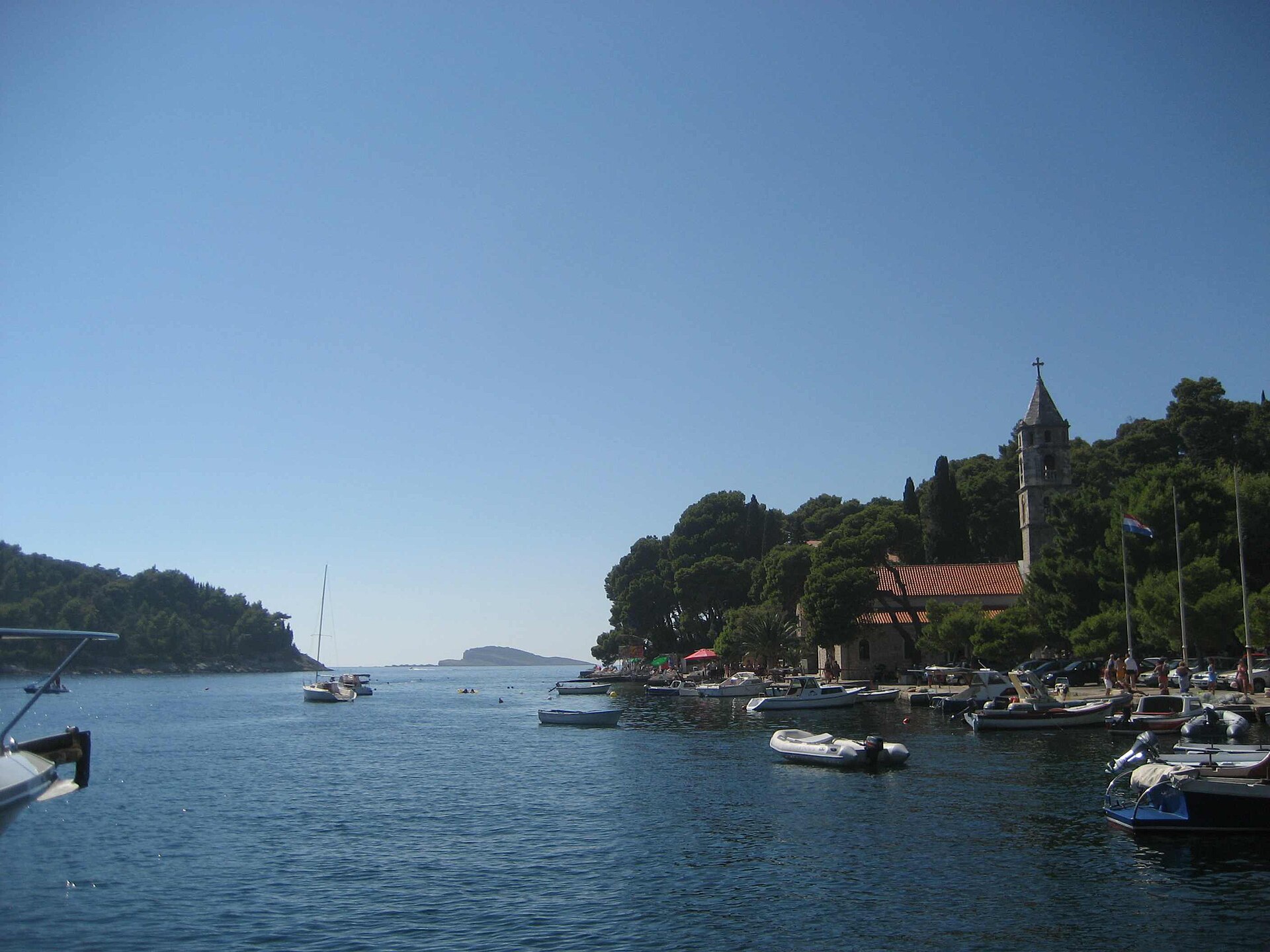
Konavle is a municipality and small historical region at the very south of Croatia, southeast of Dubrovnik. It stretches from Cavtat to the Montenegrin border and covers roughly 209 km2. This is a part of Dalmatia where vineyards, olive groves and village festivals replace the crowds on the city walls. Where is Konavle and how far is it from Dubrovnik? The region lies about 30 km from Dubrovnik. Cavtat is its largest settlement and the main base for visitors, set on a bay with a historic centre and a palm-lined seafront promenade. Further south is Molunat, a fishing village with attractive beaches and one of the few coastal settlements in the area. Inland lies the Konavle valley, a patchwork of fields, vineyards and small villages. What is there to see in Konavle? Cavtat deserves a walk of its own. In the local cemetery stands the Račić family mausoleum, built in 1922 and designed by the sculptor Ivan Meštrović. The house where the painter Vlaho Bukovac was born in 1855 now holds a gallery named after him, devoted to one of Croatia's most admired portrait and landscape artists. Nearby you will also find a Franciscan monastery and the church of Our Lady of the Snows, where medieval altarpieces can be seen. Čilipi is a village associated with folklore. On Sunday afternoons it hosts shows of traditional dance and folk music, and visitors can learn about local crafts, especially embroidery. The folk costume seen in Dubrovnik often originates from Konavle. Molunat is a good choice for a quiet day by the water, away from the largest resorts. What is the history of the region? In antiquity the area was inhabited by the Illyrian tribes of the Plereians and Ardians, conquered by the Romans in the 2nd century BC. Present-day Cavtat was then the Roman town of Epidaurum. Traces of a Roman aqueduct that carried water from the mountains near Vodovađa to Cavtat can still be seen. Konavle was briefly independent in the 9th century and later spent centuries under the rule of the Republic of Dubrovnik. What is the region like today? The landscape is shaped by vineyards, olive groves and fruit and vegetable growing. Agritourism has been growing in recent years: farms welcome guests and serve local wine, olive oil and regional dishes. Frequently asked questions Is Konavle far from Dubrovnik? About 30 km, so it makes an easy half-day trip or longer. What is the largest settlement in Konavle? Cavtat, which is also the most convenient place to stay. When can I see folklore? In Čilipi, shows take place on Sunday afternoons. Who is the region for? Travellers looking for a quieter alternative to Dubrovnik, with history, wine, beaches and local food. Practical tips It works well to combine Cavtat, Čilipi and Molunat in one trip, leaving time for tasting local products at a farm. Beaches can be busy in summer, so visit villages and the valley earlier in the day. Bring some cash for small purchases from local producers and comfortable shoes for Cavtat, where some lanes climb steeply.
-

Sveti Ivan Žabno
Sveti Ivan Žabno
Sveti Ivan Žabno is a municipality in northern Croatia, in Koprivnica-Križevci County. It groups sixteen villages across farming country near Križevci, and suits travellers who prefer quiet countryside to the busy coast. Where is it and how big is it? The municipality covers roughly 106.6 km². In 2011 it had 5,222 inhabitants. The administrative centre is the village of Sveti Ivan Žabno, and the municipality includes 16 settlements, among them Brdo Cirkvensko, Brezovljani, Cepidlak, Cirkvena, Hrsovo, Kenđelovec, Kuštani, Ladinec, Markovac Križevački, Novi Glog, Predavec Križevački, Rašćani, Sveti Petar Čvrstec, Škrinjari and Trema. What is the history of the area? People have lived here for a very long time. Finds confirm settlement from the late Stone Age through the Bronze Age and into the Middle Ages. Brezovljani stands out as one of the richest sites of the Sopot culture, a Neolithic farming culture. The place name first appears in documents in 1201 as Xabiniza. In the 16th century, Ottoman raids led to the region being resettled, and the area became part of the Habsburg Military Frontier. In 1954 the communist authorities renamed the settlement, and the municipality was called Žabno until 1990, when the traditional name returned. What sights can you see? Among the main buildings is the parish church of St. John the Baptist in Sveti Ivan Žabno, which gives the municipality its name. In Cirkvena stands the Church of the Visitation of Mary. In Trema you will find the Church of St. Julian, described as one of the rare early Baroque sacred buildings from the 16th and 17th centuries that has kept its original appearance. For fans of religious architecture, it is a good reason to leave the main roads. There is also a memorial plaque marking the founding of the first Croatian livestock breeders' association in 1908. The area has long been known for cattle breeding, and that agricultural thread captures the character of the region well. Who is this area for? It is a destination for visitors combining sightseeing in northern Croatia with trips inland: rural landscapes, old churches, traces of prehistoric cultures and local farming history. The municipality is not built around a single headline attraction. You explore it by visiting village after village and church after church, ideally by car, since the settlements lie some distance apart. Frequently asked questions How many settlements does Sveti Ivan Žabno have? Sixteen, including Brezovljani, Cirkvena, Trema and Ladinec. How many people lived here in 2011? 5,222. What is the oldest thing here? Settlement traces reach back to the late Stone Age, and Brezovljani is one of the richest Sopot culture sites. The first written mention of the place dates to 1201. Has the municipality always had this name? No. From 1954 to 1990 it was called Žabno. What should I see first? The church of St. John the Baptist, the Church of the Visitation in Cirkvena and the early Baroque Church of St. Julian in Trema.
-
Lobor
Lobor
Gmina Lobor (Croatian: Općina Lobor) is a small municipality in northern Croatia, in Krapina-Zagorje County, at the foot of the Ivančica massif. The 2021 census counted about 2,700 residents across just over 43 square kilometres. For visitors it offers a quiet corner of Zagorje with well-preserved monuments, a pilgrimage church and an archaeological site of regional importance. Where is Lobor and what is the area like? The municipality lies in the Hrvatsko Zagorje region, north of Zagreb, among wooded hills and vineyards. The landscape is typical of this part of Croatia: gentle slopes, scattered hamlets, roadside chapels and views towards the Ivančica range. The settlement was first mentioned in 1257 as Castrum Lobor, a fortress. The name is sometimes traced to a Latin word for work or laboratory, though sources disagree on its origin. What should you see in Lobor? Church of Our Lady of the Mountains (Majka Božja Gorska). This pilgrimage church stands on a hill called Gora, on the slope of Ivančica. It has drawn Marian pilgrims for centuries and is among the most important destinations in the municipality. The hill itself was inhabited in prehistoric times, when a hillfort controlled the road running through a nearby gorge. Loborgrad. The Keglević family began building this castle in the 17th century after leaving the older castle at Lobor. It is regarded as one of the most valuable castles in Zagorje. Today it houses a care home for adults, so access to the interior is limited, but the exterior can be admired. Chapel of St. Anthony. A votive chapel with a statue in the Zazidje park at the foot of Gora, built by the Keglević family in 1703. Parish church of St. Anne. A late Baroque church dominating the village centre, with the parish house to its north. Chapels in nearby hamlets. In Petrova Gora you will find the Romanesque chapel of St. Peter, once a parish church, and in Martinščina the Gothic chapel of St. Martin with frescoes. Several buildings in the municipality are registered cultural monuments. Why does the Gora site matter? Gora hill is one of the most notable archaeological sites in northern Croatia. Finds include Bronze and Iron Age traces, Roman-era material and an early Christian church with an octagonal baptistery from the 5th to 6th centuries. Lobor was also an important centre of power in the early Middle Ages, a subject studied in a project funded by the Croatian Science Foundation. A difficult chapter of history During World War II the Ustaše set up a concentration camp at Loborgrad for Jewish and Serb women and children. At least 200 people died there. Between 1920 and 1923, after the First World War, the castle also hosted a hospital run by Russian doctors. The place has a complex past, and a visit deserves respect. Frequently asked questions Can you tour Loborgrad castle? The castle works as a care home, so interiors are not normally open to tourists. It is best viewed from outside; check lobor.hr for current information. Where is Lobor municipality located? In northern Croatia, in Krapina-Zagorje County, in the Hrvatsko Zagorje region. How many people live there? About 2,700 in 2021; the 2011 census recorded 3,188. Who is it for? Travellers who enjoy quiet trips through lesser-known regions: fans of sacred architecture, history, archaeology and walks in the Ivančica hills. What should you see first? The Church of Our Lady of the Mountains on Gora, Zazidje park with the chapel of St. Anthony, and the village centre with St. Anne's church.
-
Mače
Mače
Gmina Mače (Općina Mače) is a small rural municipality in northern Croatia, in Krapina-Zagorje County, in the Zagorje region. It lies at roughly 46.09° N, 16.04° E, in hilly countryside north of Zagreb. It suits travellers who prefer to see Croatia away from the coast: hilltop churches, village landscapes and nearby thermal spas. Where is Mače and how many people live there? The municipality belongs to Krapina-Zagorje County. It had 2,534 residents in the 2011 census and 2,258 in 2021, so it remains a quiet, rural place. It is made up of nine settlements: Delkovec, Frkuljevec Peršaveški, Mače, Mali Bukovec, Mali Komor, Peršaves, Veliki Bukovec, Veliki Komor and Vukanci. The village of Mače itself is the centre of the municipality. What is there to see in Mače? The main landmark is the Church of the Immaculate Conception of the Blessed Virgin Mary, built in 1574. It is a single-nave building with a semicircular sanctuary, given a Baroque makeover in the 18th century. The church became the centre of the parish, while the village served as an administrative hub where regular, well-known annual fairs were held. What is the history of Mače? Mače was first recorded in written documents in 1444, as a parish. An older and better-known name for the area is Komor. In the 13th century Komor was an independent estate, exempt from the authority of the royal prefects. It belonged to one of the oldest families in Zagorje, the Bedeković family of Komor. The old name lives on today in two of the municipality's settlements, Veliki Komor and Mali Komor. What is nearby? The well-known thermal spa of Sutinske Toplice is close by, a natural addition to a visit if you want to relax in thermal waters. The wider Zagorje region offers more that can be combined with a trip to Mače: the Krapina Neanderthal Museum, the 15th-century Veliki Tabor Castle, and the Staro selo open-air museum in Kumrovec, which includes the birthplace of Josip Broz Tito. Trakošćan Castle, set beside a lake, is also in the region. Frequently asked questions Is Mače a town? No. It is a rural municipality of nine settlements, with about 2,300 residents according to the 2021 census. What is the most important monument? The Church of the Immaculate Conception of the Blessed Virgin Mary, dating from 1574 and given a Baroque makeover in the 18th century. Where does the old name Komor come from? In the 13th century Komor was an independent estate of the Bedeković family, one of the oldest families in Zagorje. Is there a spa nearby? Yes, Sutinske Toplice, a thermal spa located close to the municipality. Is it worth planning a full day here? Mače works best combined with other places in Zagorje: a short walk around the village and church, then castles, museums and thermal baths elsewhere in the region.
-
Draganić
Draganić
Draganić is a village and municipality in central Croatia, in Karlovac County. It lies in the lowland of the Pokupsko area, southwest of Zagreb, and the municipality covers about 72.5 square kilometres. It suits travellers who prefer to see rural Croatia, far from the coast. How many people live in Draganić? The municipality had 2,741 residents in 2011 and 2,646 in 2021. It is a small, rural community where daily life moves slowly and homes are scattered among fields, meadows and woods. What is the history of Draganić? The earliest written record of the area dates from 1249. In 1264, King Béla IV granted land to three warriors named Kreso, Kupiša and Rak. The local community of nobles was never subject to serfdom or to large magnate estates, which is why you will not find grand noble castles here. That community lasted until 1848. A parish church of St George at Šipak is first mentioned in 1334, showing that settlement and religious life here run deep. What should you see in Draganić? The best-known monument is the wooden Chapel of the Holy Trinity, built in 1689. It is decorated with frescoes and protected as a cultural monument. Wooden sacred architecture is rare in this part of Croatia, so the chapel is a good reason to leave the main road. The area is also known for traditional wooden houses and folk costume. If you enjoy short walks with a view, look for two nearby hills, Piramida and Sveti Juraj (St George). Both offer views over the Pokupsko lowland. Who is this place for? Draganić works well for people who like: rural landscapes and quiet surroundings, wooden sacred architecture, short hill walks with views, learning about local history and traditions. It makes a good stop on a trip through Karlovac County, for example combined with a visit to nearby Karlovac. Frequently asked questions Where is Draganić located? In Karlovac County, in the central part of Croatia. Is Draganić a town? No. It is a rural village and municipality with 2,646 residents in 2021. Are there castles here? No. The local nobility was not tied to magnate estates, so no large residences were built. A wooden chapel from the 17th century survives instead. When was the Chapel of the Holy Trinity built? In 1689. It has frescoes and is protected as a monument. Where can you see the surroundings from above? From the nearby hills Piramida and Sveti Juraj, which overlook the Pokupsko lowland.
-
Stubičke Toplice
Stubičke Toplice
Stubičke Toplice is a spa town in northern Croatia, in Krapina-Zagorje County, about 40 kilometres north of Zagreb. It is also the seat of the municipality of the same name. It makes a quiet getaway in the continental part of the country, with a long tradition of health tourism. Where is Stubičke Toplice and how do you get there? The town lies in the Zagorje region, north of the Croatian capital. The D307 state road serves it, and the L202 railway line connects it too. From Zagreb it works as an easy day trip or a base for a few restful days. The municipality was formed on 27 April 1993 out of a local community, and at the 2011 census it had 1,845 residents. What does the name mean, and why is it a spa? The name roughly means "the spa of Stubica" and sets the town apart from nearby Donja Stubica. Its fame comes from thermal springs. Hot water rises to the surface here, and a health and leisure resort grew around it, which remains the heart of the town today. What is there to see and do? The main draw is the thermal complex at Hotel Matija Gubec, known as Terme Stubaki. According to the resort, the hotel stands in the centre of town, right at the source of the healing water. Guests have indoor pools and an outdoor pool with massage waterfalls, plus a sauna area and a relaxation room. The resort also promotes massages with natural plant-based oils. The mood is calm, geared toward adults looking for peace. In winter, bathing outdoors can feel special, as the water stays warm even when the air is cold. What else is nearby? In neighbouring Donja Stubica there is a separate complex, Terme Jezerčica, with several pools and a wellness centre. The area also carries the history of the 16th-century peasants' revolt, including the Peasants' Revolt Museum and Veliki Tabor Castle, and a monument in Donja Stubica to Matija Gubec, the leader of the uprising, after whom the hotel is named. Frequently asked questions Is Stubičke Toplice a city? Formally it is a municipality, and its main settlement has the character of a spa village. How far is it from Zagreb? About 40 kilometres north of the capital. Can I get there by train? Yes, the town is on the L202 railway line. Is it worth visiting in winter? Yes, the outdoor thermal pool is one of the main reasons to come outside summer. Do I need to book? Opening hours and prices change, so check current details with the resort directly before you go. Who is it for? Stubičke Toplice suits anyone looking to recover, enjoy a calm weekend in Zagorje, or take an easy trip out of Zagreb. Thermal baths, green surroundings and historic sites close by let you plan a relaxed day without a long drive.
-
Pušća
Donja Pušća
Gmina Pušća (Općina Pušća) is a small municipality in Zagreb County, Croatia, with its seat in the village of Donja Pušća. It had around 2,700 residents in 2011. This is quiet countryside where the main draws are sacred monuments, an old manor house and short walking routes over the nearby hills. Where is Pušća and who is it for? The municipality lies in north-western Croatia, not far from Zagreb. It is not a mass-tourism destination. It suits travellers who enjoy local architecture, walks without crowds and the history of small communities, and it works well as a stop on a driving trip around the Croatian capital. What is the history of Pušća? The oldest known document mentioning the settlement dates from 1496, and the parish is recorded in 1501. The municipality became a separate administrative unit in the early twentieth century, when it was split off from neighbouring Brdovec. Sources disagree on the exact start year, so it is safest to say 1910 or 1911. What can you see in Donja Pušća? Parish church of St George The church began as a Gothic building and was later given Baroque features. The main altar honours the patron saint, and the nave holds Baroque side altars dedicated to St Catherine and the Blessed Virgin Mary. Its present appearance comes from construction and artistic work carried out between 1841 and 1858. Chapel of Our Lady of the Rosary On the hill above the church stands a chapel of the Blessed Virgin Mary of the Rosary, built in 1722. Together, the church, parish house, cemetery and chapel form a protected cultural and historical ensemble. Statue of St Florian Beside the main road stands a late Baroque stone statue of St Florian, set on a pedestal in 1778. It was placed on land belonging to the noble Hadrović family. The municipality describes it as a rare surviving work of its period. What is there in Gornja Pušća? Gornja Pušća has the Rauch manor, known locally as Rauchov dvor. It is an example of a former landowner's residence, of which few remain in the area. Are there walking trails? On Crikveni brijeg hill, a path called Staza života (Path of Life) runs from St George's church to the church of Our Lady of Čiselska. Combining the walk with the monuments will usually take a few hours. Frequently asked questions Are there major tourist attractions in Pušća? No, this is a place of small local monuments. The most interesting are St George's church, the hilltop chapel and the Baroque statue of St Florian. Where is the municipal seat? In Donja Pušća. How much time should I plan? Half a day is enough for the main monuments and a short walk on Crikveni brijeg. Is it a good day trip from Zagreb? Yes, if you are interested in quiet village life, sacred architecture and local history rather than nightlife or beaches. In short Gmina Pušća is a peaceful corner of Zagreb County. A Gothic-Baroque church, eighteenth-century sacred monuments, the Rauch manor and a hillside path show the everyday cultural landscape of a Croatian village, far from the usual tourist routes.
-
Bistra
Poljanica Bistranska
Bistra Municipality is a local government unit in northern Croatia, in Zagreb County, just west of the capital. Its centre is the village of Poljanica Bistranska, and the territory stretches from the ridge of Medvednica mountain down to the valley of the Krapina river. It is a quiet area for visitors who want greenery, forest trails and village scenery without travelling far from Zagreb. Where is Bistra and how big is it? The municipality covers roughly 52.7 square kilometres and runs across the western slopes of Medvednica. The land descends gradually from mountain forest to the Krapina valley, so the scenery shifts within a short distance: wooded hillsides give way to open farmland at the foot of the mountain. The 2011 census recorded 6,632 residents. Bistra has existed as a local government unit since 1995. What is there to see in Poljanica Bistranska? Poljanica Bistranska lies at the foot of Medvednica and partly on its slopes. Its best-known landmark is the parish church of St Nicholas, built in 1631 next to a spring. After earthquake damage it was rebuilt several times, so its present look is the result of successive reconstructions. The village population is quoted differently depending on the source; the 2011 census gives 1,438 people. Are there hiking trails in Bistra? Yes. The municipality lies in the western part of Medvednica Nature Park, which was established in 1981 and covers about 22,800 hectares. A popular walk leads from Poljanica Bistranska up to Risnjak. Within the park, in the catchment of the Bistra stream, lies the Markovčak–Bistra forest reserve. Near the park entrance in Bistra you can see a geological column, and a protected stand of yew trees grows in the entrance area. What cultural sights does Bistra offer? In Novaki Bistranski, the former school building has been turned into a cultural and tourism centre. It is a useful stop for learning more about the area and planning a longer walk in the park. Who is this area for? Bistra suits a short escape from Zagreb: a forest walk, a modest mountain hike or a look at village corners off the usual tourist routes. It has no single headline attraction. It works better as a calm base for walking and for discovering a less visited side of Medvednica. Frequently asked questions Where is Bistra municipality located? In Zagreb County, west of Zagreb, on the western slopes of Medvednica. What is the main settlement? Poljanica Bistranska, home to the church of St Nicholas dating from 1631. Can I hike here? Yes. The municipality sits within Medvednica Nature Park, and a well-known route leads from Poljanica Bistranska to Risnjak. Should I check details before visiting? Yes. Confirm current opening times and visitor details on the municipality website (bistra.hr) and the nature park website (pp-medvednica.hr).
-
Rakovica
Rakovica
Rakovica is a municipality in Croatia at the southernmost tip of Karlovac County, in the historical region of Kordun. It borders Plitvice Lakes National Park, which makes it a quieter base or stopover for travellers who want to avoid the crowds around the lakes themselves. Where is Rakovica and what is it like? The municipality covers roughly 256 square kilometres and includes 26 settlements scattered along the Korana River. The 2021 census counted about 2,200 residents, while the village of Rakovica itself has fewer than 250. This is a rural, sparsely populated corner of the country where nature, silence and open landscape are the main draw. Croatia classifies the area as one of special state concern, reflecting long-running depopulation and modest infrastructure. What is there to see in Rakovica? Barać Caves. A network of underground passages and chambers explored on guided tours. They reportedly reopened to visitors in 2004. They are one of the municipality's main attractions and a good plan for a day with unsettled weather. Drežnik Grad. The ruins of a defensive fortress, once linked to the Frankopan family, standing above the Korana canyon. The stronghold is associated with an early centre of local power, and the site offers views over the river valley. Restoration work is still going on, so access to some parts may vary. The Korana canyon. The river has cut deep gorges through this area, and walking along its banks gives a real sense of Kordun's wild character. Why does Rakovica matter in Croatian history? The place gave its name to the Rakovica revolt of October 1871. Eugen Kvaternik, a politician and nationalist activist, led an armed uprising against Austria-Hungary, demanding an independent Croatian state. It lasted only a few days and ended in defeat, and Kvaternik was killed. Despite its failure, the revolt remains an important episode in Croatian memory of the struggle for sovereignty. Rakovica also appears in the events of the Second World War: in July 1941, Italian troops withdrew from it and from Drežnik Grad towards Ogulin. How to plan a visit Rakovica fits well as a stop on the route between Karlovac, Slunj and the Plitvice Lakes. Many tour operators pair the Barać Caves with excursions to Plitvice or to the waterfalls of nearby Rastoke. Accommodation is easiest to find in private guesthouses and apartments in the municipality and its surroundings. Before you go, check current cave opening hours and guided-tour times, as they are not fixed year-round. Frequently asked questions Is Rakovica close to Plitvice Lakes? Yes. The municipality borders the national park, so the drive to the lakes is short. What does the name Rakovica mean? In the Serbo-Croatian languages the name derives from a word meaning crab. Many places across the Balkans share it, so make sure you are heading to the municipality in Karlovac County. Is one day enough? It is enough for the caves, the castle ruins and the story of the 1871 revolt. To explore Kordun properly, set aside more time and combine it with Plitvice. Are the Drežnik Grad ruins fully open? Not always. Restoration work is under way, so parts of the site may be restricted.
-
Marija Gorica
Marija Gorica
Marija Gorica Municipality is a small municipality in the western part of Zagreb County, Croatia, close to the Slovenian border and roughly 30 kilometres from Zagreb. In 2011 it had 2,233 residents. It is a quiet rural area of hills, vineyards and forests, a good break from the capital's bustle. Where is Marija Gorica and how far is it from Zagreb? The municipality lies west of Zagreb near the Slovenian border, at about 45.92 N, 15.73 E. At around 30 kilometres from the Croatian capital, it works as a day trip by car or as a base for exploring the countryside around the city. The landscape is made of gentle hills covered with vines and woodland, with the Sava valley below. Where does the name come from, and what is the story of the church? The settlement takes its name from the patron saint of the local parish church, dedicated to the Assumption of the Blessed Virgin Mary. The church's history goes back to the 16th century, when a Franciscan monastery stood here with Saint Peter as its first patron. In the second half of the 17th century the dedication changed to Mary, after a statue of the Virgin on the altar gained a reputation for healing and drew pilgrims. That devotion gave the place its present name. What heritage sites are there? The municipality has 11 registered cultural properties, mostly secular and sacred buildings. One example is Kurija Kraj Donji, a 19th-century manor house in the village of Kraj Donji, which is under heritage protection. History enthusiasts may also be drawn to the Sveti Križ area, where a hill above the Sava valley holds the remains of a Late Bronze Age and Early Iron Age settlement. Finds there include a notable princely grave. What else attracts visitors? The area is promoted for rural tourism. Visitors can expect local wineries, traditional country houses and walking trails across the surrounding hills. A bathing spot on the Sutla River is also mentioned, a welcome extra in summer. Nearby lies the village of Oplaznik, birthplace of the writer Ante Kovačić, so fans of Croatian literature can combine a visit with a literary trail. Frequently asked questions Where is Marija Gorica municipality? In western Zagreb County, near the Slovenian border and about 30 km from Zagreb. How many people live there? The 2011 figure was 2,233 residents. Where does the name Marija Gorica come from? From the patron saint of the parish church of the Assumption of the Blessed Virgin Mary, whose cult grew in the 17th century around a statue believed to heal. What heritage is worth seeing? The parish church, whose roots lie in a 16th-century Franciscan monastery, the 19th-century Kurija Kraj Donji manor house, and the archaeological site in the Sveti Križ area. Is it a good place for a countryside break? Yes. Vineyards, forests, walking trails, country homes and a bathing spot on the Sutla make it a calm alternative to sightseeing in Zagreb alone.
Earn badges for the places you visit
Download NextOnTrip, discover new places and check off your trails.