Mountains and trails in the United Kingdom
A guide to 29 Mountains and trails in the United Kingdom — with descriptions, photos and traveler visits from the NextOnTrip community. Locations spread across 19 cities and towns. Most visited by the community: Scafell Pike, Portsdown Hill, Meikle Bin.
-

The Cloud
Staffordshire Moorlands
The Cloud (also called Bosley Cloud) is a distinctive gritstone hill on the Cheshire–Staffordshire border beside Congleton, in the Staffordshire Moorlands area. Its summit stands at 343 m (1,125 ft), and the National Trust has looked after the hill since 1962. It lies a couple of miles west of the Peak District National Park boundary, yet it features on the CPRE's 2021 list of the 95 Peak District "Ethels". What will you see from The Cloud? A trig pillar marks the top, with a viewing indicator nearby to help you name what you are looking at. On a clear day the outlook takes in both counties, Congleton, Biddulph and Macclesfield, Greater Manchester, and further out the Shropshire hills, the mountains of Wales and the Pennines. Plenty of flat rocks near the summit make a good spot for a break. How do you get to The Cloud? Most walkers start from the Timbersbrook picnic site and car park (postcode CW12 3PP) on Weathercock Lane, signposted off the A54 Buxton Road. The short direct climb includes roughly 136 steps. You can also approach from Rushton Spencer on the Staffordshire side. Which walking route should you choose? Short climb from Timbersbrook: a quick ascent suitable for most reasonably fit visitors. Timbersbrook loop: about 7.2 km (4.5 miles), around 2 hours, with roughly 250 m of ascent. Rushton Spencer circular: about 11.2 km (7 miles), roughly 3 hours along the Staffordshire Way, with several steep sections. Gritstone Trail: the hill sits on stage 3 of this long-distance path, between Congleton and Kidsgrove. There are no facilities on the hill, so carry water. The Coach and Horses pub is a short distance away. When is the best time to visit? Pick a clear day, since the panorama is the main reward. Paths can turn slippery and muddy after rain, so wear sturdy footwear. Early morning and late afternoon give softer light for photos. Frequently asked questions How high is The Cloud? 343 m (1,125 ft) above sea level. Is The Cloud inside the Peak District National Park? No. It sits outside the official boundary, about two miles away, but it counts among the Peak District Ethels. Is there an entry fee? No. The hill is National Trust land and the footpaths are open to walkers. Check current parking arrangements at Timbersbrook before you go. Are there toilets or a café at the top? No facilities exist along the route. For food and drink, head for the nearby pub.
-

Ben Hope
Ben Hope is the most northerly Munro in Scotland, a peak above 3,000 ft that rises to roughly 927 m in Sutherland, in the far north of the Highlands. It sits south-east of Loch Hope and stands entirely on its own, which makes the climb feel remote and the views unobstructed. Where is Ben Hope and what sets it apart? The mountain overlooks the Flow Country, the vast peatland of northern Scotland, with no taller neighbour to block the outlook. Its shape is a rough triangular wedge: a great crag falls away on the western side, while two lower shoulders run off to the south and north-east. The whole area is protected as the Ben Hope Site of Special Scientific Interest, designated by NatureScot for its geology, upland habitats and plant life. What will you see? Dun Dornaigil – a well-preserved broch beside the road below the mountain. Many walkers stop here on the way back to the car. Alpine flowers – plentiful in season, even though the ground is very rocky. Summit panorama – on a clear day you look across moorland, lochs and towards the north coast. How do you climb Ben Hope? The usual approach begins near Dun Dornaigil, just off the A838 in Strath More. Another option is a small car park at the end of the minor road running north from Altnaharra. The round trip is about 7.5 to 8 km and typically takes 3 to 5 hours. The first stretch beside a stream is steep and rough, easing higher up. Route-finding needs care on the way down, where you have to avoid the crags, and the top is often in cloud. Carry an OS Explorer 447 map or an up-to-date guidebook rather than relying on a phone. When should you go? Late spring and summer work best: the days are long and the alpine flowers are out. Weather in the north of Scotland changes quickly, so check the mountain forecast on the day and pack warm waterproofs and sturdy boots. Winter conditions call for experience and proper equipment. Frequently asked questions Is Ben Hope really the most northerly Munro? Yes. It is the northernmost Scottish summit over 3,000 ft. How long does the ascent take? Guides usually quote 3 to 5 hours for the round trip of around 7.5 to 8 km. Your pace and the weather make the difference. Is the route difficult? It is steep and stony at the start, and navigation can be tricky on the descent among the crags, especially in low cloud. No scrambling is required. Is there anything else worth seeing nearby? Yes: the Dun Dornaigil broch, Loch Hope, and the Flow Country, one of Europe's largest blanket bogs.
-
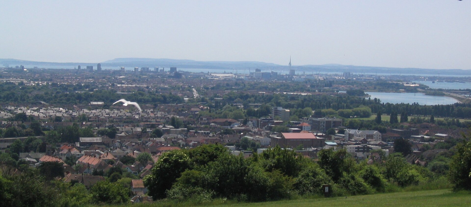
Portsdown Hill
Portsmouth
Portsdown Hill is a chalk ridge rising above Portsmouth in Hampshire, on England's south coast. It runs along the northern edge of the city and is best known for its sweeping outlook over the harbour, the Solent and the islands. A line of Victorian forts sits along the crest, which makes the hill a good stop for both panorama seekers and military-history fans. What is Portsdown Hill? The ridge is an inlier of chalk, pushed to the surface by an upfold in the local rock layers called the Portsdown Anticline. Its highest point, 131 m above sea level, lies inside Fort Southwick. The hill stands on the mainland, north of Portsea Creek, the narrow channel separating the mainland from Portsea Island, where most of Portsmouth and its major naval base are found. What can you see from the top? The southern slope looks out over Portsmouth, Gosport, the Solent and Hayling Island, with the Isle of Wight behind. To the north lie the Forest of Bere and, in clear weather, the South Downs and Butser Hill. A convenient starting point is the car park and viewpoint on Portsdown Hill Road, just east of Fort Widley, where walking routes along the slope begin. Which forts are on the hill? The forts were built after the 1859 Royal Commission to defend Portsmouth against an attack from inland. Their scale and cost earned them the nickname "Palmerston's Folly". From west to east they are Fareham, Wallington, Nelson, Southwick, Widley and Purbrook, and each has had a different fate: Fort Nelson has been restored and houses the Royal Armouries' artillery museum. It is Grade I listed, and Hampshire County Council points to its view across Portsmouth, Gosport and the Solent. Fort Widley is owned by Portsmouth council. It holds a stable and community rooms, and runs tours on summer weekends. Fort Purbrook is a Scheduled Monument with an activity centre, and it opens now and then for craft fairs. Fort Southwick served as an Admiralty research site for many years and was sold for housing in 2003. Forts Wallington and Fareham have given way to industrial estates and are not visitor sites. Nature and walking Part of the hill is a Site of Special Scientific Interest, and most of the southern flank is open-access land under the Countryside and Rights of Way Act 2000. The Portsdown Hill Countryside Service looks after the site with help from volunteers and community groups. Portsmouth City Council notes plenty of parking on the hilltop. When should you go? Pick a clear day for the longest views, including the Isle of Wight and the distant South Downs. Evenings, when lights come on across the harbour, are popular with photographers. Check opening times for the forts and museum with their operators before you travel. Frequently asked questions How high is Portsdown Hill? The summit is 131 m above sea level, inside Fort Southwick. Is there parking? Yes. A car park with a viewpoint sits on Portsdown Hill Road, east of Fort Widley. Check current rules with Portsmouth City Council. Which forts can you visit? Fort Nelson is the easiest, with its Royal Armouries museum. Fort Widley runs tours on summer weekends, and Fort Purbrook opens occasionally. What can you see from Portsdown Hill? Portsmouth, Gosport, the Solent, Hayling Island and the Isle of Wight to the south, and the Forest of Bere, South Downs and Butser Hill to the north.
-
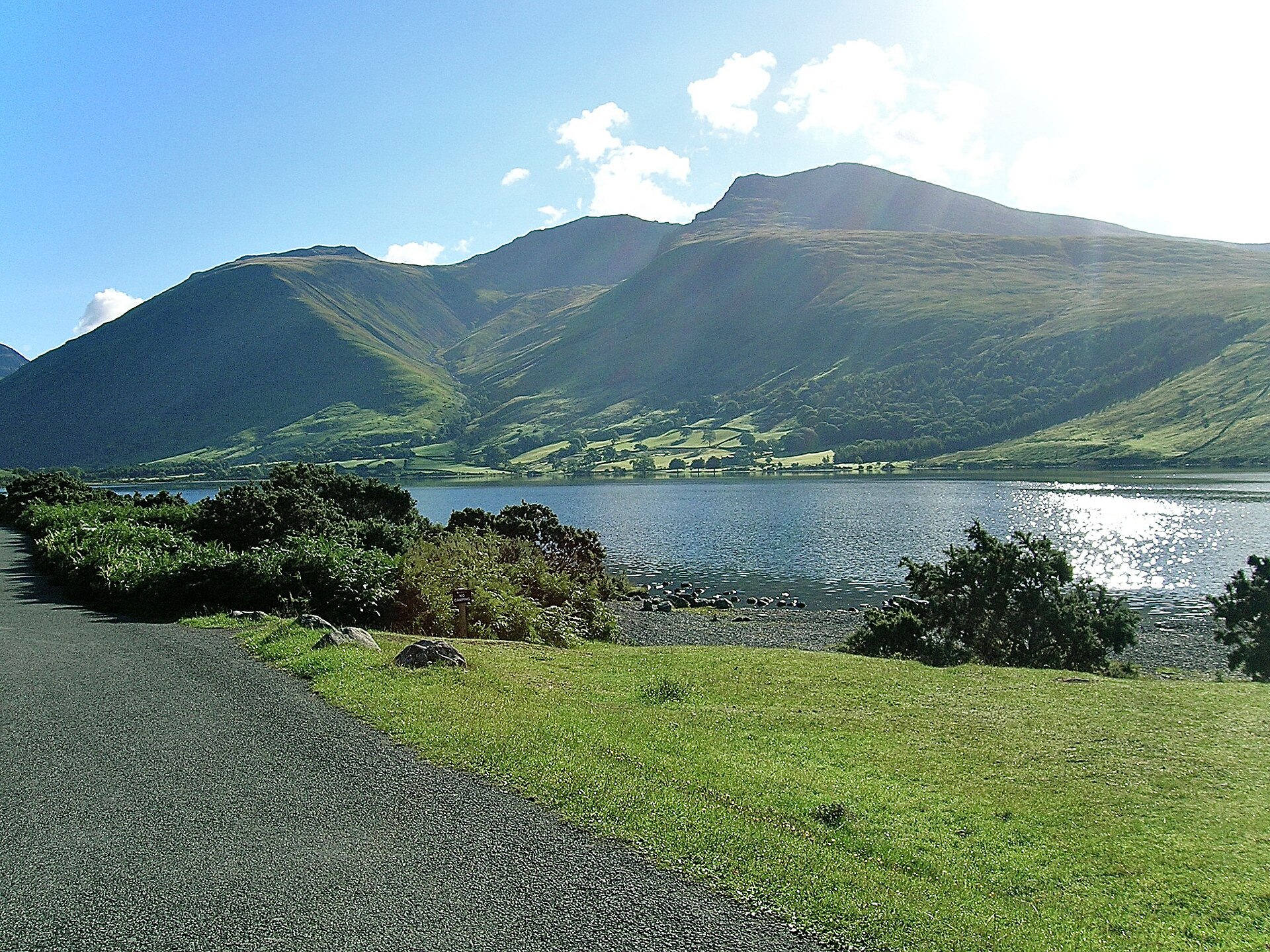
Scafell Pike
Scafell Pike is England's highest mountain, rising 978 m above sea level in the Lake District National Park, Cumbria. It belongs to the Scafell massif, the remains of an extinct volcano, and is counted among the Southern Fells. The summit is a plateau of broken boulders, and on a clear day the views take in lakes, neighbouring ridges and, far off, Morecambe Bay. What makes Scafell Pike special? Height is only part of the story. The mountain is also a war memorial: after the First World War it passed into the care of the National Trust in remembrance of Lake District men who died in the conflict. A slate tablet is set into the summit cairn, which Trust rangers rebuilt in 2018 for the centenary of the Armistice. Scafell Pike is one of fourteen Lakeland summits given to the Trust in what became known as the Great Gift. How do you climb Scafell Pike? Your choice depends on fitness and navigation skills. From Wasdale Head is the shortest and most popular option: roughly 6 km each way, about 900 m of ascent, and usually around 3 hours up. It starts at the National Trust's Lake Head car park. The Corridor Route from Wasdale Head (about 7.7 km, nearly 970 m of ascent, 3-4 hours) is less steep but longer and more demanding to follow. It includes short stretches of easy scrambling and a few narrow, exposed paths. From Seathwaite in Borrowdale makes a bigger day: about 15 km round trip, around 1,000 m of climbing and six hours or more. For the full round trip from Wasdale Head, plan on 5-6 hours including the descent and a stop at the top. Where do you park? The main car park is Lake Head at Wasdale Head. It holds a few dozen cars, is free for National Trust members and pay-and-display for everyone else. Do not leave vehicles on the village verges. Seathwaite offers only limited roadside spaces, which fill fast on summer weekends, and the narrow lane is unsuitable for large vehicles. When should you go, and what should you watch for? Late spring, summer and early autumn are the best seasons, but Lake District weather changes quickly. In cloud, finding the way across the rocky summit area is genuinely difficult. Carry a map and compass or a reliable navigation device, a warm layer, waterproofs, sturdy boots, water and food. After heavy rain, Lingmell Beck on the Wasdale Head approach can be awkward to cross because there is no bridge. In winter you need proper equipment and the skills to use it. What else can you combine it with? Walkers often pair the climb with neighbouring Scafell or the Corridor Route, and many treat Scafell Pike as the English leg of the Three Peaks Challenge, which links the highest mountains of Scotland, England and Wales within 24 hours. If it is your first trip to the area, consider staying in Wasdale or nearby Eskdale so you can set off at dawn, before the crowds arrive. Frequently asked questions How high is Scafell Pike? 978 m (3,209 ft), making it the highest and most prominent mountain in England. How long does the ascent take? About 3 hours one way by the shortest route from Wasdale Head. Longer routes from Seathwaite take six hours or more for the round trip. Do you have to pay for parking? At Lake Head car park in Wasdale Head, non-members of the National Trust pay. Members park free. Is it suitable for beginners? The paths are clear, but this is a full mountain walk with a lot of climbing and fast-changing weather. Good footwear, a map and navigation skills are essential, especially in poor visibility.
-

Scout Scar
Brigsteer
Scout Scar, also called Underbarrow Scar, is a limestone hill in the English Lake District, west of Kendal in Cumbria. It rises above the village of Underbarrow and reaches 235 m (771 ft). It is one of the most accessible viewpoints near Kendal. What is Scout Scar? It is a limestone escarpment: the ground rises gently on the eastern side and drops steeply away to the west. That gives the ridge wide open views while keeping the walk up short and undemanding. The hill has a topographic prominence of about 109 m, which makes it a HuMP, a hill that stands at least 100 m clear of its surroundings. Why visit? Alfred Wainwright covered Scout Scar in a chapter of The Outlying Fells of Lakeland. The summit he describes is a lower top of 764 ft (233 m), about 270 m south of the true high point. His recommended anticlockwise route also takes in neighbouring Cunswick Scar (679 ft, 207 m), and the two hills combine into one easy circuit. What is there to see on top? The ridge carries "The Mushroom", a round stone shelter built in 1912. A view indicator (toposcope) runs around its rim and names the fells you can pick out in the distance. On a clear day the view takes in the Lakeland fells, the Howgills and even Morecambe Bay. Looking north you can spot Red Screes and Fairfield among others. Which route should you choose? Short loop: a family-friendly circuit of about 2.6 km with roughly 36 m of ascent, taking around an hour. There are no public toilets or cafes on site, so bring your own supplies. Scout Scar and Cunswick Scar: an easy circular walk linking the two Wainwright outlying fells. Kendal to Sizergh Castle: a route of about 7 miles across limestone grassland with far-reaching views. Route lengths vary with the starting point, so check the plan of your chosen loop before setting out. Frequently asked questions How high is Scout Scar? The highest point is 235 m (771 ft). The lower top described by Wainwright is 233 m. Is it a hard walk? No. The approach from the gentler eastern side is short, and the shortest loop is only about 2.6 km. Take care near the steep drop on the western edge. Where is Scout Scar? West of Kendal, above the village of Underbarrow, in Cumbria, England. What is the Mushroom? It is a viewing shelter dating from 1912 on the ridge, ringed by a toposcope that identifies the visible fells. Are there toilets or food nearby? There are no public toilets or eateries on the hill itself. Who is it for? Scout Scar suits families, anyone who likes a short walk with a big view, and hill-baggers working through Wainwright's outlying fells. For a longer day, pair it with Cunswick Scar or the route to Sizergh Castle. Pick a clear day: the panorama is the main attraction here.
-
Culver Down
Sandown
Culver Down is a chalk down on the eastern edge of the Isle of Wight, England, just north of Sandown. It is the easternmost point of the entire island and one of the best viewpoints on the south coast, combining an easy grassy ridge walk with sea views and traces of old coastal defences. Where is Culver Down and how do you get there? The down rises above Sandown Bay, between Sandown and Bembridge. Most visitors drive to one of the car parks on the summit or at Culver Cliff and set off on foot. The ground is open and grassy, and the wind near the cliff edge can be strong, so bring a windproof layer and sturdy shoes. What is there to see? The best-known landmark is the Yarborough Monument, a Grade II listed memorial to Charles Anderson Pelham, the 2nd Earl of Yarborough, who died in 1846. It was paid for by public subscription, following a proposal from the Royal Yacht Squadron committee. It originally stood on nearby Bembridge Down and was moved to make way for one of the Palmerston-era forts. The down also holds Culver Battery, part of a chain of fortifications protecting the sea approaches to Portsmouth. It was completed in the early twentieth century with two gun emplacements, which were upgraded in 1924, and it was manned in both world wars. A signal station here was one of the wireless stations Guglielmo Marconi built along the south coast; its site is now a car park. The hill's history goes back further still, since beacons here formed part of a medieval early-warning system against a possible French invasion. Is it worth walking here? Yes. A popular route is about 4.5 km and takes roughly an hour and a half. It starts at the National Trust car park near Bembridge Fort, passes the monument, then continues to the battery and the coast. A shorter loop of about 2.5 miles begins at Culver Cliff car park. Both are easy and suit most walkers. The Culver Haven pub stands next to the monument, handy for a rest afterwards. Nearby you can also visit Bembridge Windmill, the island's last surviving windmill, looked after by the National Trust. Where does the name come from? The name may derive from an Old English word for a dove (culfre), though this is a suggestion rather than a certainty. Frequently asked questions Where exactly is Culver Down? On the eastern end of the Isle of Wight, north of Sandown. Is it the easternmost point of the island? Yes, Culver Down is the island's easternmost point. How long is the walk? An easy loop of about 4.5 km takes around 1.5 hours. What can I see besides the views? The Yarborough Monument, the remains of Culver Battery, and nearby Bembridge Fort and Bembridge Windmill. Is the walk difficult? No, the paths are easy, though it can be very windy near the cliff.
-
Lochnagar
Lochnagar is one of the best-known peaks of the eastern Grampians in Scotland, standing in Aberdeenshire within Cairngorms National Park. Known in Gaelic as Beinn Chìochan, it rises roughly five miles south of the River Dee and close to Balmoral Castle. Its highest point, Cac Càrn Beag, reaches 1,155 m (3,789 ft), and the hill counts as a Munro, one of Scotland's summits above 3,000 ft. What makes Lochnagar special? The mountain's character comes from its north face: a deep glacial corrie ringed by cliffs, with a small lochan at its foot. The name originally belongs to that lochan. In winter the cliffs draw climbers, and in summer they draw walkers for the view. The top is a broad, stony plateau with sweeping views across the Cairngorms and down Deeside. The hill also sits on the Balmoral estate, which gives the area its royal associations. How do you get to the summit? Most walkers start from the Spittal of Glenmuick car park, at the end of a narrow public road that runs about 13 km into Glen Muick from Ballater. Parking is charged, and in summer the lots can fill early. The standard out-and-back or loop route is around 19 km with about 900 m of ascent, and takes 6 to 7 hours. The path is well worn. A short detour to Meikle Pap is worthwhile for a look at the cliffs of the northern corrie. From there the route crosses the plateau to the summit cairn. Alternatives include: a loop that returns along Loch Muick past the Glas Allt waterfall, roughly 19 to 20 km; a route from Easter Balmoral near the castle, about 24 km and 8 to 9 hours; a long circuit linking five Munros, around 28 to 30 km and up to 9 hours. When should you go, and what are the risks? Late spring, summer and early autumn are the best seasons. The plateau has few landmarks and the cliffs run along its northern edge, so in mist you need solid navigation and a safe distance from the edge. In winter the route needs crampons and an ice axe, and summer route descriptions no longer apply. Weather at altitude changes quickly, so carry warm layers, a map and a torch. What else is nearby? After the descent, Loch Muick is a pleasant stop, a long lake in Glen Muick with an easy path along its shore. Ballater, Braemar and Balmoral Castle all lie in Deeside, and the area combines well with other Cairngorms walks. Frequently asked questions How high is Lochnagar? The summit, Cac Càrn Beag, stands at 1,155 m above sea level. Where is the best place to start? The Spittal of Glenmuick car park, south of Ballater. It gives the shortest and most popular approach. How long does the climb take? The standard route takes 6 to 7 hours. Variants with several Munros or from Balmoral take 8 to 9 hours. Can you climb it in winter? Yes, but only with winter experience, crampons, an ice axe and the skill to navigate in poor visibility.
-
Eccles Pike
High Peak
Eccles Pike is a lone gritstone hill in High Peak, Derbyshire, roughly three miles west of Chapel-en-le-Frith inside the Peak District National Park. At 370 metres (1,210 ft) it is modest in height, yet because nothing crowds it, the summit gives some of the widest views in this corner of the Peak. What will you see from Eccles Pike? The rock here is gritstone, turning pinkish towards the top. Looking west, you can pick out Manchester; to the east the broad Kinder Scout plateau fills the skyline. Walk guides also list Chinley Churn, Mount Famine, South Head and Brown Knoll among the landmarks. Combs Reservoir lies immediately south of the hill and features in many loop routes. How do you get there? Most walkers start in Combs village or in Chapel-en-le-Frith. Roadside parking in Combs is limited; route descriptions suggest leaving the car near the phone box, or using the Bee Hive pub car park, which has charged non-customers about £2 a day. You can also begin from Whaley Bridge, or take a train or bus to Chinley or Buxworth and walk in. Which routes are there? Distance depends on where you start: about 5 miles (8 km) from Combs, 2 to 3 hours; a short loop from Chapel-en-le-Frith or Bradshaw Hall, around 3 miles, with a brief detour to the top, about 1.5 hours; 4.7 miles from Whaley Bridge, including a steep climb to the summit; longer outings of up to 19 km (11.8 miles) linking the hill with Whaley Bridge, Buxworth and Fernilee, as run by Ramblers groups. The final ascent is steep but short. The hill is open walking country with no admission fee. When should you go? Choose a clear day, when Kinder Scout and the Manchester skyline are visible. Early morning and late afternoon light suits the pink stone. After rain the path beside Combs Reservoir can turn very boggy, and near the dam it may be underwater if the reservoir is full. Wear sturdy boots and bring a windproof layer, since the top is exposed. Frequently asked questions How high is Eccles Pike? 370 metres (about 1,210 ft) above sea level. Do you have to pay to climb it? No. The paths are public. The only possible cost is parking at the pub. How long does a walk take? Short loops take 1.5 to 2 hours, the standard route from Combs 2 to 3 hours, and the long variants from Whaley Bridge and Chinley several hours more. What can you combine with the walk? A circuit of Combs Reservoir below the hill, and a stop in Chapel-en-le-Frith, the nearest town, which has cafes, pubs and a railway station.
-
Bennachie
Oyne
Bennachie is a range of hills in Aberdeenshire, north-east Scotland, and the area around the village of Oyne is one of the favourite places to start a hike. It is modest in height next to the Highlands, but it rises out of flat farmland and can be spotted from far away. One of its tops carries the remains of an Iron Age fort. What will you see on Bennachie? The highest top, Oxen Craig, stands at 528 m. The best-known is Mither Tap (518 m), a rocky, boulder-crowned summit. Its crest still shows the defensive ramparts of an Iron Age hillfort, so the climb pairs views with a touch of archaeology. Because the range stands alone above low ground, you look out across the Aberdeenshire plain and, in clear weather, to distant hills. Who looks after the hill and what facilities are there? Most of the range belongs to Forestry and Land Scotland, which maintains the path network, several car parks and a visitor centre at the eastern foot of the hills. There are picnic tables outside the Bennachie Centre and benches along the lower trails. The Bailies of Bennachie, a volunteer charity founded in 1973, helps with path work and with environmental and archaeological projects. How do you get there and which route should you pick? The easiest start is the car park at the Bennachie Centre near Oyne and Chapel of Garioch, where marked paths begin. The ascents of Oxen Craig and Mither Tap from here are fairly easy. Another option is the Back o' Bennachie car park on the far side of the range. Guides rate that route as moderate, at roughly 9.8 km with about 485 m of climbing, and it passes through the rocky summit of Mither Tap. For a bigger day out, a loop that adds Millstone Hill covers about 15 km with around 700 m of ascent. The web of paths lets you mix and match sections to suit your legs. When is the best time to visit? The hills are open all year, but late spring, summer and early autumn are the most comfortable, with long days and drier paths. In winter trails can turn muddy or icy and the weather on top changes fast, so bring sturdy boots and an extra layer. Allow a few hours for the return trip to Mither Tap from the visitor centre, including time at the viewpoints. Frequently asked questions What is the highest point of Bennachie? Oxen Craig at 528 m. Mither Tap is lower (518 m) but is the one with the Iron Age fort. Is there a visitor centre? Yes. The Bennachie Centre sits at the eastern foot of the range, with picnic tables nearby and marked trails starting from it. Is the climb difficult? The routes up Oxen Craig and Mither Tap from the centre are considered fairly easy. Longer loops, such as the one including Millstone Hill, are clearly more demanding. Who manages the hill? Mostly Forestry and Land Scotland, with volunteers from the Bailies of Bennachie helping on paths and projects.
-
Haddon Hill
Brompton Regis
Haddon Hill is a heather-covered ridge beside the village of Brompton Regis in west Somerset, on the south-eastern edge of Exmoor National Park. It runs east to west and looks down on Wimbleball Lake. It suits visitors who want wide views from an easy walk. Where is Haddon Hill? The ridge sits close to Hartford, inside the civil parish of Brompton Regis. The valleys of the Haddeo and the Exe separate it from the main Exmoor upland. Most of the hill lies within the national park, whose boundary follows the B3190 between Watchet and Bampton. That road crosses the eastern end of the ridge. How do you get there and where do you park? Drive in along the B3190. The Haddon Hill car park sits beside it on a sharp bend, just east of the hill, and has toilets, including accessible ones. No buses serve it. A pay-and-display car park on the western shore of the lake is the alternative, giving a longer approach. For refreshments, try the seasonal lakeside kiosk or the pubs in Brompton Regis and Upton. What can you see? A trig point marks the top of the ridge at 355 m (1,164 ft), grid reference SS 962286. From there you look north across Wimbleball Lake in the Haddeo valley and out over the Exmoor hills. The hill is grazed by one of the park's two herds of Exmoor ponies. From late summer the heather and gorse draw insects, including the rare heath fritillary butterfly, and plenty of birds. Which walk should you choose? Most of the upper hill is open access land under the Countryside and Rights of Way Act 2000. Two public footpaths cross it north to south, and many tracks follow its length. Short stroll: the park's Exmoor Explorers route is about 2.3 km, takes roughly 40 minutes and climbs around 30 m. Longer loop: from the car park to the summit, down towards Hartford and back along the lake, about 4.2 miles (6.8 km). Lake circuit: starting from the western car park by Wimbleball Lake gives a walk of about 7.6 miles (12 km). The climb is steady rather than steep. Some routes are muddy near the start, so wear sturdy footwear. When should you visit? Late summer into early autumn is best, when the heather blooms. Clear days give the best views over the lake and surrounding hills. The ridge is exposed, so carry a windproof layer. Frequently asked questions Is there an entry fee for Haddon Hill? No. The upper hill is open access for walkers, and there is a car park beside the B3190. How long does a visit take? The short route takes about 40 minutes. Allow a few hours if you add the lakeside descent. Can I get there by public transport? No, buses do not reach the car park. Arrive by car. Are there toilets and food nearby? Toilets are at the car park. A kiosk operates seasonally by the lake, and pubs are in Brompton Regis and Upton.
-
Crouch Hill
Cherwell
Crouch Hill is a grassy rise on the south-western edge of Banbury, in the Cherwell district of Oxfordshire. About a mile from the town centre, it has served as a lookout for centuries and today makes an easy, quiet outing with wide views. It is not the Crouch Hill street in north London, nor any of the other hills sharing the name. What is Crouch Hill? The hill is partly man-made. Its cone-shaped summit was shaped by people, as nineteenth-century antiquarian digs established. Local historian Alfred Beesley suggested in 1841 that the mound was raised to exchange signals with settlements and camps across the district, some of them in Northamptonshire. That remains a theory, yet it explains why the spot has always been prized for its outlook. Why go? For the panorama. From the top you take in Banbury's rooftops and church spires, then open fields and gently rolling country stretching into Oxfordshire and Warwickshire. The hill stands where two old routes cross, the Salt Way and Banbury Lane, and the town itself grew around that junction. During the siege of Banbury in 1644, in the Civil War, William Waller camped his troops here. How do you explore it? The ground is open, with informal paths across the grass, so ordinary walking shoes will do. It suits a short stroll or a picnic, and it can anchor a longer walk: the Salt Way runs as a bridleway to the west and south of town and links the hill with the surrounding farmland. Check a map for current access and parking before you set out, because there are few visitor facilities. What else fits into the visit? Treat Crouch Hill as a companion to a day in Banbury. After the climb you can head back into the centre, look over the churches you spotted from above, and stop at a local cafe. History fans get extra context: knowing that ancient trackways crossed nearby, and that Parliamentary troops camped here in 1644, makes it easy to see why the place mattered. Families will appreciate the open space to roam, and photographers get a clean horizon above the town and the fields around it. When is the best time to visit? A clear day gives the best view, especially in the morning or shortly before sunset, when low light picks out the fields and town. Grass paths can turn muddy after rain, so summer and early autumn are the easiest seasons. FAQ Where is Crouch Hill? On the south-western side of Banbury, in Cherwell district, Oxfordshire, England. Is the hill natural? Partly. The conical top is artificial, as nineteenth-century investigations showed. What can you see from the summit? Banbury and its church spires, plus open farmland across Oxfordshire and Warwickshire. Do I need a ticket or special gear? No. It is open ground with informal grass paths, so regular walking shoes are enough.
-
Warton Crag
Lancaster
Warton Crag is a limestone hill near Lancaster in north-west Lancashire, just north-west of the village of Warton. At 163 metres, it is the highest point in the Arnside and Silverdale Area of Outstanding Natural Beauty. The summit carries the remains of a small hillfort and looks out over Morecambe Bay. What is there to see at Warton Crag? The main reward is the outlook. The hill rises clearly above its surroundings, so on a good day you can take in the bay and the landscape around it. Up top you will find the ramparts of a small hillfort with several rings of defences. It is generally thought to be Iron Age, though the dating is not firmly settled. A route called Occupation Road to Beacon leads to the summit, where a beacon once stood as a signal point. The hill is shared between several owners: Lancashire County Council, the Wildlife Trust for Lancashire, Manchester and North Merseyside, Lancaster City Council and the RSPB. Two parts are designated Local Nature Reserves, Warton Crag and Warton Crag Quarry, the latter a former quarry. For a visitor this simply means one large walking area made up of several sections with different managers. How do you get to Warton Crag? By car, head for the free car park on Crag Road beside the old quarry, run by Lancashire County Council. Published sources give two different postcodes and grid references for the car park (LA5 9RB and LA5 9NE), so check the exact spot in your satnav before setting off. Without a car, take a bus to Warton village and get off on Main Street. From there it is a steep walk of about 15 minutes uphill to the car park. Is Warton Crag suitable for everyone? Not really. The slopes are steep, the paths rocky and the walks fairly demanding. The reserve is not accessible to wheelchair users or visitors with limited mobility. Wear sturdy shoes with good grip. Ticks are present in large numbers, so wear long trousers and check your clothes after the walk. When should you visit? Pick a clear day, since visibility decides how much you get from the climb. In sharp, clean air the view over the bay is at its best. After rain the rocky paths can turn slippery, so take extra care on the steep stretches. A short visit can be just the walk from the car park to the top and back, while a longer one can link several sections of the reserve. What should you bring? Good walking boots, water and a windproof layer, as the exposed summit can feel breezy. There is little in the way of facilities on site, so carry your own food. Binoculars are useful for scanning the bay from above, and a map or route app helps because there are several paths to choose from. Frequently asked questions How high is Warton Crag? It stands at 163 m above sea level and is the highest point of the Arnside and Silverdale AONB. Its prominence is 126 m, which puts it on the list of HuMPs, hills with at least 100 m of prominence. Do you have to pay for parking? No. The car park on Crag Road is free and is managed by Lancashire County Council rather than the Wildlife Trust. Can you get there by public transport? Yes, by bus to Warton village, with a stop on Main Street. From there expect about 15 minutes of steep uphill walking to the car park. Is the site accessible for people with disabilities? No. The steep, rocky ground makes the reserve unsuitable for wheelchairs and for people with limited mobility.
-
Lodge Hill, Buckinghamshire
Bledlow
Lodge Hill is a chalk hill in Buckinghamshire, just north of Bledlow Ridge and a short distance from Bledlow and Princes Risborough. Its roughly 31.8 hectares are protected as a Site of Special Scientific Interest, and the whole area sits inside the Chilterns Area of Outstanding Natural Beauty, west of London. What will you see at Lodge Hill? The slopes are covered in chalk grassland mixed with patches of scrub. This is a scarce habitat in lowland England, and it supports a rich insect community, butterflies in particular. Naturalists have also recorded a rare snail here, along with badgers and slowworms. In summer the grassland carries a good show of orchids, including pyramidal, bee and frog orchids, which makes the hill a fine target for anyone who enjoys wild flowers. The hill has a human story too. Two round barrows, dated to the late Neolithic or early Bronze Age, still stand here, and Beaker-culture pottery fragments have been found with them. There are also remains of an Iron Age settlement. People were living and burying their dead on these hills long before the Romans arrived. How do you get there and where can you walk? The Ridgeway, one of Britain's oldest long-distance trails, crosses the site. That makes Lodge Hill an easy addition to a longer Chilterns walk, and the paths around it can be strung into a half-day or full-day loop. The hill is open to walkers but it is access land rather than a staffed nature reserve, so expect no visitor centre or marked nature trail. Wear proper footwear and keep to the paths to protect the grassland. Bledlow Ridge, Bledlow and Princes Risborough are the nearest places for food, a pub stop or a bed for the night. When is the best time to visit? Late spring and summer are best, when the grassland is in flower and butterflies are on the wing. Autumn is quieter, with good colour across the rolling Chilterns landscape. Chalk paths can turn slick after rain, so walking boots are a sensible choice in winter and early spring. Who is it for? Walkers following The Ridgeway or shorter circular routes. Botanists and butterfly or orchid watchers. Anyone curious about prehistory who wants to see burial mounds and the traces of an old settlement. Londoners looking for a day out in protected countryside. Frequently asked questions Is this the same Lodge Hill as the one in Kent? No. Kent has a different site with the same name, known for its woodland and nightingales. This Lodge Hill lies in the Chilterns near Bledlow Ridge. Are there any rules for visitors? Because it is an SSSI, visitors should leave plants and wildlife undisturbed, take litter home and keep dogs under control, as on any protected site. Can I walk The Ridgeway here? Yes. The trail passes across the hill, so Lodge Hill sits naturally on a route through the Chilterns. What is worth seeing in summer? Orchids flowering on the chalk grassland and the butterflies that feed there. The Bronze Age barrows are on the hill as well.
-
Fan Bwlch Chwyth
Fan Bwlch Chwyth is a 603 m hill in the Fforest Fawr range of South Wales, inside Bannau Brycheiniog (Brecon Beacons) National Park in Powys. It suits walkers who want quiet moorland and big skies instead of the queues on Pen y Fan. Where is Fan Bwlch Chwyth? The summit sits in the western part of Fforest Fawr, among broad grassy ridges. An Ordnance Survey trig pillar marks the top, around grid reference SN 912217, and walkers' guides place the highest ground a few metres east of it. You may also see the name spelled "Fan Bwlch Chywth", so search both versions when planning. How do you get there? Most walkers start near Cray Reservoir, beside the A4067 between Sennybridge and Ystradgynlais. The trailhead sits around SN 896222. Public transport here is very limited, so a car is the practical choice. Which routes lead to the top? Shorter option – about 7 miles (11 km) across open moor to the trig pillar, either out and back or as a loop along the ridge. Three-summit round – about 10 miles (16 km), roughly 670 m of climbing and around seven hours on foot. It links Fan Gyhirych (about 725 m), Fan Nedd and Fan Bwlch Chwyth. Group outings, including some led by the Ramblers, use the same start and finish on the ridge. Much of the way follows faint or no paths. Carry an OS map, a compass or a GPS app. What will you see? The ridge opens up views across Fforest Fawr, the upper Tawe valley and the higher Bannau Brycheiniog summits, including Fan Fawr (about 734 m) and Fan Brycheiniog (802 m). The scenery is grass, peat and scattered rock. The area lies within Fforest Fawr Geopark, known for its geology and caves. When should you go? Late spring to early autumn, on days with clear visibility, gives the best conditions. The terrain is exposed, and in poor weather fog, strong wind and boggy ground make navigation harder. Bring waterproofs, sturdy boots and enough water, as there are no shops or huts along the way. Frequently asked questions How high is Fan Bwlch Chwyth? It stands at about 603 m above sea level. Is the walk difficult? There is no scrambling, but the distance, lack of clear paths and changeable weather make it a moderately demanding day. Where do I start? At Cray Reservoir off the A4067. From there you climb onto the ridge and continue to the trig pillar. Are there other summits nearby? Yes. Fan Gyhirych and Fan Nedd share the same ridge system, and Fan Brycheiniog rises further east.
-
Nine Standards Rigg
Nine Standards Rigg is a moorland ridge in the Pennine Hills, a few miles south-east of Kirkby Stephen in Cumbria, England. A line of tall stone cairns on its flank can be spotted from the valley far below, and they make this one of the best-known landmarks on the Coast to Coast walk. What are the Nine Standards? The ridge takes its name from the cairns, known locally as "standards", built just below the summit. They stand roughly 400 m from the highest point and about 12 m lower, which is why they show up so clearly from the surrounding dales. Despite the name, the count has not stayed at nine: old photographs show anywhere from seven to twelve, as the stonework has been rebuilt many times. Written references go back to the 16th century, and the cairns appear on 18th-century maps. Nobody knows why they were built. Theories include a boundary marker between Westmorland and Swaledale, a military bluff meant to fool an enemy, a warning to Scottish raiders and grave markers. The cairns have been Grade II listed since 1984. Where is it and how high? The summit, which is also called Hartley Fell, reaches 662 m (2,172 ft). It lies within the North Pennines Area of Outstanding Natural Beauty, just outside the Yorkshire Dales National Park and close to the Cumbria and North Yorkshire boundary. An Ordnance Survey trig pillar marks the top, on the watershed. The view from the cairns is better than from the pillar. How do you get there? Most walkers start in Kirkby Stephen and follow the Coast to Coast path eastward. It crosses fields and then opens onto bare moorland. In the drier months the classic route described by Alfred Wainwright is available. Because of peat erosion, land managers mark alternative routes in wet seasons to spare the most fragile ground, so watch for signs at the fork. Park in Kirkby Stephen, where there are several places to leave a car. Why stay on the path? This is blanket bog. Stepping off the trodden line widens the damage, and after rain parts of the ground turn soft. A major repair scheme called "Raising the Standard" was carried out on the path below the ridge: stone slabs were flown in by helicopter and sphagnum moss was planted to help the peat recover. Keep to the waymarked line. When should you visit? Dry, calm days from late spring to early autumn are best. The exposed ridge can switch to wind and cloud quickly, so pack layers, a map or GPS and waterproof boots. In poor visibility it is easy to lose the path. Frequently asked questions How many cairns are there at Nine Standards Rigg? The name says nine, but the count has varied between seven and twelve because the cairns get rebuilt. Are the cairns at the highest point? No. The summit with the trig pillar is about 400 m away and stands at 662 m. The cairns sit slightly lower. Is it on the Coast to Coast route? Yes. The trail crosses the ridge after leaving Kirkby Stephen on the way towards Swaledale. Are the cairns protected? Yes, they have been Grade II listed since 1984. Do not climb on them or move stones.
-
Brea Hill
Brea Hill (pronounced "Bray Hill") is a rounded hill on the north Cornish coast, rising beside the River Camel estuary at the southern end of Daymer Bay, close to Trebetherick and Rock. At 62 metres (203 ft), it is a modest climb, yet the summit carries Bronze Age burial mounds and opens up wide views over water, sand and cliffs. What is there to see on Brea Hill? A line of ancient tumuli sits along the top. Visitor accounts count three or four of them, with one noticeably better preserved and the largest badly worn. The bedrock is Devonian slate, typical of this stretch of Cornwall. From the crown you look across the Camel estuary to the dunes and houses of Rock, then along the coast towards Polzeath and Pentire. The surrounding area falls within the Rock Dunes Site of Special Scientific Interest, so keep to the paths and stay out of the dune vegetation. How do you get to Brea Hill? Most people walk it as part of the South West Coast Path between Rock and Polzeath, around 4 km one way. The route passes over Cassock Hill and Brea Hill, then skirts Daymer Bay and Trebetherick Point. The final ascent is short but steep in places, so wear proper footwear. Many walkers set off from Rock near the quarry car park; others start at Daymer Bay and climb from that side. When should you visit? The hill can be walked all year. Clear days give the best outlook, and evening light on the estuary is especially good. In summer the beaches at Daymer Bay and Polzeath fill up, so mornings or early autumn are calmer. The summit is exposed, and it can feel cold in wind even when the beach is warm. What can you combine with the walk? Extend the outing to Polzeath, a well-known surf beach, or to the cliffs of Pentire Head. In Rock you can eat and catch the ferry across to Padstow. Together these make a half-day or full-day coastal walk. Frequently asked questions How high is Brea Hill? 62 metres, so the climb takes roughly a quarter of an hour from the path below. What is on the summit? Bronze Age tumuli in a row. Sources vary between three and four. Where can you park? Usually at Rock Quarry car park or near Daymer Bay beach. Check charges and rules on arrival. Is it suitable for families? Yes, if children can manage a short, steep ascent. The full Rock to Polzeath route of 4 km is a multi-hour outing.
-
Lippitts Hill
Epping Forest
Lippitts Hill is a hill within Epping Forest, near High Beach and Waltham Abbey in Essex, on the north-eastern fringe of London. It is not a ticketed attraction with visitor signage. Its interest lies in a long record of defending and policing the capital from a patch of woodland. What is Lippitts Hill? It is a rise of forested ground inside the Epping Forest boundary. Rather than a nature reserve or viewpoint, it is known for military and police roles. For anyone curious about London's recent history, it shows how suburban greenery was used as a back-line for the city's security. What is its history? First World War: a gun emplacement stood on the hill. Second World War: an anti-aircraft site. In 1941 the US 184th Anti-Aircraft Artillery installed guns, an underground control room and blockhouses. From 1944: a British prisoner-of-war camp. It left behind a memorial to the American forces and a concrete figure of a man made by a German prisoner, Rudi Webber. After the war the site was used for civil defence. Early 1950s: a Cold War anti-aircraft operations room was built. By 1956 fast jet bombers and missile technology had made the system obsolete, and it was abandoned. How did the police use the site? In 1960 the area became a Metropolitan Police training ground, a role it kept until 2003. After three officers were killed in west London in 1966, firearms training took place here, although a new pistol range was only approved in 1973. The Met's Firearms Training Unit was based here and ran the force's first firearms course. The main training centre today is at Gravesend. From 1976 Lippitts Hill served as a base for police helicopters, first borrowed from the Army and flown over London. The unit joined the National Police Air Service (NPAS) in 2014. Operations shifted to North Weald Airfield around late 2019, and NPAS returned to the hill at the end of 2021. Can you visit, and how do you get there? The site is an operational police facility, so do not expect open access. Plan a walk through the surrounding Epping Forest and the village of High Beach instead. Driving is the easiest option, or take the Central line to Loughton and continue by local bus or on foot. Check current timetables and path maps before you go. When should you go? Spring and early autumn are the best seasons for Epping Forest: tracks are drier and the woods are at their most colourful. After winter rain some paths turn muddy. Walk during daylight, as the forest gets dark quickly. Frequently asked questions Where is Lippitts Hill? In Epping Forest near High Beach and Waltham Abbey in Essex, on the edge of London. What was it used for during the world wars? Both wars saw gun positions here. In 1941 a US anti-aircraft unit built an underground control room, and from 1944 a prisoner-of-war camp operated on the site. Is it still a police site? Yes. It became a Metropolitan Police training area in 1960, and since 1976 it has hosted police helicopters, now run by the National Police Air Service. What else is worth seeing nearby? The wider Epping Forest and High Beach, which suit a full day's walk away from central London.
-
Scrabo Hill
Newtownards
Scrabo Hill rises above Newtownards in County Down, Northern Ireland. A tall tower crowns the summit and can be spotted from miles around, while a country park at its foot offers short, rewarding walking routes. It is one of the most accessible viewpoints within reach of Belfast. What is there to see on Scrabo Hill? The landmark is Scrabo Tower, a turreted Victorian monument finished in 1857. It commemorates Charles Stewart, the 3rd Marquess of Londonderry, who died in 1854 and had served under Wellington in the Napoleonic Wars. Architect Charles Lanyon drew up the plans. His entry was not the competition's top-ranked one, but it was the one that fitted the budget. Sources quote the tower's height at roughly 38 metres, though figures vary. The slopes hold old sandstone quarries. Stone from here went into well-known buildings, among them Belfast's Albert Memorial Clock. The quarries are disused and now largely hidden by trees, and their geology earned them protection as an Area of Special Scientific Interest. The summit is also said to have hosted a prehistoric hill fort. What are the views like? From the top you look out over Strangford Lough and the Mourne Mountains, and on a clear day the Scottish coast comes into sight. Choose a day with good visibility, ideally in the morning or late afternoon. How do you get there, and how long does it take? The hill sits right beside Newtownards, a short drive from Belfast. The standard loop starts at the country park car park. It covers about 1.4 miles (2.2 km) and is rated moderate, with a climb that is short but steep. Allow one to two hours including time at the summit. Can you go inside the tower? Access to the interior is limited. After severe water damage in 2014, the tower opens only on certain days, usually Thursday to Sunday in summer. Inside, an exhibition by Ards Historical Society tells the story of the hill and the monument. Check current dates with Visit Ards and North Down before you set out. Frequently asked questions Do I need a ticket for the hill? Walking in the country park and up to the summit does not require one. Check the entry rules for the tower itself before you travel. How long is the walk to the top? The loop from the car park is around 2 km. Plan on one to two hours at a relaxed pace with time for the views. What can you see from Scrabo Hill? Strangford Lough, the Mourne Mountains and, in clear weather, the Scottish coast. Is the route easy? It is moderate. The ascent is short but steep, so wear sturdy footwear. Why was the tower built? As a memorial to the 3rd Marquess of Londonderry, completed in 1857.
-
St Martha's Hill
Guildford
St Martha's Hill is a wooded hilltop just outside Guildford in Surrey, set in the Surrey Hills Area of Outstanding Natural Beauty between the town and the village of Chilworth. A small church, St Martha-on-the-Hill, crowns the summit, and the North Downs Way runs over the top along the line of the old Pilgrims' Way. It makes an easy, rewarding half-day outing from Guildford. What will you see on St Martha's Hill? The hill rises to roughly 175 m, ranking 18th among Surrey's hills. It belongs to the Greensand Ridge, at the point where that ridge comes closest to the North Downs. From the open ground by the church you get a broad outlook: south over Albury and Chilworth towards the South Downs on a clear day, and north-east across to Newland's Corner, another Surrey Hills viewpoint. The church is Grade II listed. A 12th-century predecessor left behind its font and some medieval stonework built into the present structure, which was rebuilt in the mid-19th century. It serves a tiny parish and is popular for weddings, so a weekend visit may coincide with a ceremony. How do you get to the top? The usual route starts in Guildford. Follow the River Wey along the Wey South Path, join the North Downs Way and pass through Chantry Wood. The climb that follows is steady and fairly long. The descent can be sandy and steep in places, so wear shoes with decent grip. The summit also falls on the North Downs Way section from Guildford to Gomshall (about 7 miles), where it works well as a rest or lunch stop. There are benches at the top for a picnic with a view. No shop or cafe stands on the summit, so bring food and water. When is the best time to visit? Pick a clear day, when visibility reaches the South Downs: spring and autumn mornings or summer evenings work best. The sandy sections get slippery after rain, and winter dusk comes early, so plan to be back down before sunset. Frequently asked questions How long does the climb take? From Guildford expect about an hour each way on foot. Allow half a day if you combine it with the viewpoint, the church and a longer stretch of the North Downs Way. Is there an entrance fee? No. The hill and the trail are open to all, and the church can be admired freely from outside. Is the walk difficult? It needs no special fitness, but the ascent is sustained and the way down is sandy and steep in places. Comfortable footwear is enough. What else can you combine it with? Continue along the trail towards Gomshall for more Surrey Hills views, or head to nearby Newland's Corner for another wide panorama.
-
Great Shunner Fell
Great Shunner Fell is a Pennine summit in the Yorkshire Dales, North Yorkshire, England. At 716 metres it ranks as the national park's third-highest peak and is the top of Wensleydale. It sits between the villages of Hawes and Thwaite, and the Pennine Way crosses its broad back. What can you see from the top? The summit is a wide, peaty dome rather than a sharp ridge, but the outlook is generous. On a clear day Wensleydale opens out to the south, Ribblesdale to the southwest and Swaledale to the north. Further away you can pick out the hills of Cumbria and County Durham beyond the A66 corridor. A cross-shaped windbreak with stone seats stands on the top, and the trig pillar is built into its northern arm, so there is always a sheltered corner for a snack. How do you get up Great Shunner Fell? The shortest approach starts in Thwaite, in Swaledale. The out-and-back walk is roughly 12 km and takes most people 3 to 4 hours. The way is waymarked as the Pennine Way: first a track climbing from the village, then a flagged path across the moor. Longer options begin in Hawes on the Wensleydale side. Walkers' guides give the Hawes route as about 15 to 18 km, taking 4 to 6 hours. Starting from Hardraw trims several kilometres off the distance. Where do you park? Space at Thwaite is very limited. Only a handful of cars fit near the start of the track a few hundred metres above the village. When it is busy, use the pay-and-display car park in Muker, about a mile away, or begin from Hawes instead. When should you go? Late spring, summer and early autumn bring drier ground and better views. The terrain is open and exposed, and weather on the Pennines can turn quickly. Pack warm layers, a waterproof, a map and boots that cope with wet ground. In low cloud the view is lost, so check the forecast for the higher fells before setting out. Frequently asked questions How high is Great Shunner Fell? It stands at 716 m above sea level, making it the third-highest summit in the Yorkshire Dales and the highest point of Wensleydale. How long does the walk take? From Thwaite allow 3 to 4 hours for the round trip of around 12 km. From Hawes plan on 4 to 6 hours. Do you need climbing experience? No. It is a hill walk on a clear Pennine Way path with no scrambling. You do need reasonable fitness and clothing for changeable weather. What is at the summit? A cross-shaped stone shelter with seats and a trig point, plus views over three dales: Wensleydale, Ribblesdale and Swaledale.
-
Buckden Pike
Buckden
Buckden Pike is a fell above the village of Buckden at the head of Wharfedale, inside the Yorkshire Dales National Park in North Yorkshire. At 702 metres it falls just short of being the highest summit in the area, an honour that belongs to neighbouring Great Whernside. A trig point sits on the top, and a memorial to a Polish bomber crew stands a short walk along the ridge. What will you see on Buckden Pike? The summit looks over the upper dale and the surrounding Dales fells. The terrain is open, exposed moorland with big skies and no shelter. Stretches of the ridge path are paved to cross the wet ground, and the walk from the summit to the memorial is quick and easy. Who is remembered at the memorial? South of the summit, a small stone cairn on a concrete base carries a plain Latin cross. A cast fox's head is set into the base, along with pieces of duralumin from the Wellington's geodetic airframe. The monument marks the loss of Wellington N2848, which crashed on Starbotton Fell, near the southern end of Buckden Pike, in January 1942 on a cross-country training flight from RAF Bramcote. The wreckage tore through the drystone wall on the ridge and broke apart. The cairn honours five Polish airmen. The tail gunner, Sergeant Jozef Fusniak, survived. The story goes that he followed fox tracks through the snow down to the hamlet of Cray, to the north, where help was raised. He later built the memorial himself and died in 2017. It was unveiled in the early 1970s. How do you get up Buckden Pike? The simplest route starts in Buckden and climbs a bridleway that is steep and boggy in places. A popular loop from the village is roughly 12 to 13 km with 550 to 580 m of ascent, which walkers report taking two to three hours. A longer circuit of about 17 km (around 576 m of climbing) follows the ridge via Tor Mere Top, drops to the Starbotton road at Cam Head, then returns on the Dales Way through Starbotton. You can also start from Starbotton for about 13.5 km. Stronger walkers link the fell with Great Whernside and Kettlewell. When should you go, and what should you bring? The moor is exposed and the weather changes quickly, so pick a day with good visibility. Waterproof boots help, since the higher ground stays soggy after rain. After snowfall the route is harder to follow in winter, so carry a map and compass or GPS. FAQ How high is Buckden Pike? 702 metres, just below Great Whernside. Why is there a Polish memorial on the summit ridge? It marks a Wellington bomber crewed by Polish airmen that crashed here in January 1942 during a training flight. One man, Jozef Fusniak, lived and later built the memorial. How long does the walk from Buckden take? Walkers report two to three hours for the shorter loop. The longer route through Starbotton takes several hours. Is it a difficult walk? Gradients are never severe, but the first climb is steep and the ground is boggy. The longer circuit is graded moderate.
-
Black Mount
Black Mount is a mountain range in the Scottish Highlands, in the Argyll and Bute council area, stretching between Glen Orchy and Glen Coe. Its eastern flank looks over the vast bog of Rannoch Moor, while Bridge of Orchy and Glen Etive lie to the west and north. For hillwalkers it offers big Highland scenery with far fewer people than Ben Nevis. What is Black Mount? The name comes from a former forest, now largely gone. What remains is a set of open grassy and rocky ridges holding four Munros (summits over 3,000 ft): Stob a' Choire Odhair, Stob Ghabhar, Creise and Meall a' Bhùiridh. The last of these, at 1,108 m, is the highest in the range. Lower hills such as Ben Inverveigh and Meall Tairbh fill the gap between the range and Bridge of Orchy. What will you see? From the southern tops, especially Stob a' Choire Odhair, the outlook is east across Rannoch Moor, a flat expanse of lochans and peat. Stob Ghabhar is the more dramatic hill, with a steep climb, a rocky crest and real exposure that impresses even seasoned walkers. Loch Tulla and the Victoria Bridge area sit beside the road and serve as the usual starting points. On the Glen Coe side, the White Corries lifts climb the slopes of Meall a' Bhùiridh. How do you plan a walk? The classic round starts at the car park near Victoria Bridge, west of Loch Tulla. Taking in Stob a' Choire Odhair and Stob Ghabhar and returning by a stalkers' path comes to roughly 22 km with about 1,350 m of climbing. The full traverse of all four Munros, finishing at White Corries, covers a similar distance with around 2,000 m of ascent. Ground is rocky in places and boggy lower down, and the stretch from Stob Ghabhar toward Bealach Fuar-Chathaidh has no consistent path. Carry a map, compass and warm layers, because Highland weather turns quickly. How do you get there? The range lies along the A82 between Glasgow and Fort William, so a car is the simplest way in. Bridge of Orchy also has a station on the West Highland line, and the West Highland Way passes below the hills, which makes it easy to pair a summit day with a stretch of that long-distance trail. When should you visit? Conditions are best from late spring to early autumn. In winter the higher ground calls for winter skills and equipment. During the deer-stalking season, check local access information, since much of the land is private estate. Frequently asked questions How many Munros are in Black Mount? Four: Stob a' Choire Odhair, Stob Ghabhar, Creise and Meall a' Bhùiridh. Which summit is highest? Meall a' Bhùiridh, at 1,108 m. Where do walks start? From the car park near Victoria Bridge by Loch Tulla, or from Bridge of Orchy. Is it suitable for beginners? No. Routes exceed 20 km, some sections have no path and need navigation, and the weather can be harsh. Can you ride a lift up? Lifts operate from the Glen Coe side at White Corries on Meall a' Bhùiridh; check current operating times before you travel.
-
Rivington Pike
Chorley
Rivington Pike is a hilltop above the village of Rivington near Chorley in Lancashire, north-west England. It rises on the slopes of Winter Hill within the West Pennine Moors, and from its ridge you can take in much of the region. Just below the summit stands Pike Tower, a stone landmark that local walkers have used as a waypoint for generations. What is Rivington Pike? The hill stands at roughly 363 metres above sea level and is one of the best-loved half-day walks for people from Bolton, Wigan and Preston. The nearest towns are Adlington and Horwich. The land and the tower are owned and managed by Chorley Council and form part of Lever Park, the former private grounds laid out by the industrialist Lord Leverhulme, now open to everyone. What will you see? Pike Tower – a small, sturdy stone tower dating from the 18th century (1733), sitting just under the top. It served as a lookout and signalling point, and bonfires have long been lit nearby on special occasions. The panorama – on a clear day you can pick out the Lancashire plain, the Irish Sea coast around Blackpool, and the hills of Wales beyond. Leverhulme's Terraced Gardens – a now-overgrown set of terraces, stairways and pavilions on the slope below the summit, ideal for a longer loop. Rivington reservoirs – the valley below the hill, with well-marked paths along the water. How do you get to the top? The easiest approach is to park near Rivington Hall Barn or along Rivington Lane and continue on foot. The climb normally takes 30 to 45 minutes on wide, well-trodden paths that are steep in places. You can also route through the terraced gardens, which makes the walk longer but more varied. By car, the drive from Manchester or Preston is usually about an hour. When should you visit? The hill is open all year. Visibility tends to be best in spring and autumn on dry, clear days. The summit is typically windy, even in summer, so bring a jacket. Paths get muddy after rain, so walking boots are a good idea. The area is also popular with mountain bikers, so weekends can be busier, and the top draws larger groups around Easter and during local events. Frequently asked questions Is there an entry fee for Rivington Pike? No. The hill and the paths through Lever Park are open to the public without a ticket. Some car parks may charge. How long does the walk take? Allow about 1.5 to 2 hours for a relaxed round trip to the summit, or up to half a day for a longer loop through the gardens and around the reservoirs. Is it suitable for children? Yes, for older children who enjoy walking. The climb is moderate, but with a pushchair or very young children expect some steep sections. Can you go inside Pike Tower? The tower stands just below the summit and is easy to view from outside. The interior is not normally open day to day.
-
Beacon Hill
Basingstoke and Deane
Beacon Hill is a chalk hill near Burghclere in the Basingstoke and Deane district of Hampshire. Its summit stands at roughly 261 metres (856 ft) and carries a well-preserved prehistoric hillfort. It is an easy half-day stop in north Hampshire that packs views, archaeology and wildlife into one short walk. Mind the name: Hampshire has two hills called Beacon Hill, and this one is by Burghclere, not the nature reserve at Meonstoke. What is there to see on Beacon Hill? The main draw is a large, single-ramparted hillfort, protected as a scheduled monument by Historic England. It dates to around 1000 BC. The hill has never been excavated, yet survey work has picked out the traces of many huts and storage pits, and the bank and ditch still stand out clearly. Inside the railings near the summit trig point lies the grave of the 5th Earl of Carnarvon, the patron behind a famous Egyptian excavation. It is a plain resting place in a striking setting. The slopes are a Site of Special Scientific Interest. Chalk grassland here flowers in spring and summer, and buzzards and skylarks are regular sights overhead. What can you see from the top? The open, grassy summit looks out over the Highclere estate, with Highclere Castle in view, and across to neighbouring Ladle Hill. On a clear day the outlook is wide. The name recalls an old warning-beacon site. The last fire in the signal chain was lit here on 5 June 2012 to mark the Queen's Diamond Jubilee. How do you get there, and what is the walk like? The route starts from a car park off the A34 (grid reference SU463576). A popular loop of about 1.4 miles climbs the hill, passes Old Burghclere and Burghclere Manor, and returns to the car park. The ascent at the start is steep, so wear sturdy footwear. Hampshire County Council manages the site and access is free. When is the best time to visit? Spring and summer, when the grassland is in flower and visibility is usually good. Choose a clear day for the best valley views, and expect slippery slopes after rain. Frequently asked questions Is there an entry fee? No. The site is open to visitors and run by the county council. How long does the walk take? The roughly 1.4-mile loop takes about an hour, including time at the summit and the grave. Can I bring a dog? Yes, but keep it on a lead from March to July and whenever livestock is near. Is this the same as Beacon Hill at Meonstoke? No. That is a different hill further south in Hampshire. The one described here sits by Burghclere, close to Highclere.
Earn badges for the places you visit
Download NextOnTrip, discover new places and check off your trails.