About this place
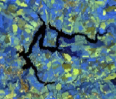
Lac de Villefranche-de-Panat is an artificial reservoir in the Lévézou area of the Aveyron department, southern France. Sitting at an altitude of 727 metres, the lake covers roughly 192 hectares and stretches for close to 4 kilometres along the boundary between the communes of Villefranche-de-Panat and Alrance.
Is the lake natural?
No - it was created by a dam built between 1948 and 1951 and commissioned in 1951 to generate hydroelectric power. The project was part of a broader post-war push to develop hydropower across the Lévézou plateau: five dams were raised in the same period, fed by local streams and rivers and linked by an underground network of galleries totalling 27 kilometres. The Villefranche-de-Panat dam itself is a 332-metre gravity dam, forming part of the Le Pouget hydroelectric complex. The lake is fed by the Alrance river, though most of its water actually arrives through an 11-kilometre gallery connecting it to the neighbouring Lac de Pareloup.
Filling the valley reshaped both the landscape and the local economy. Where farmland and river valleys once stood, a broad sheet of water now dominates the view, and from the 1960s and 1970s onward the surrounding communes leaned into tourism, building campsites, leisure facilities and beaches around the shoreline.
Where can you swim?
Two supervised, equipped beaches operate in July and August: Plage du Mayrac, on the village side of Villefranche-de-Panat, and Plage de Granouillac. Both have showers, toilets, picnic tables, sports pitches and play areas, making them suitable for a full day out with children.
What water activities are on offer?
Pedal boats, canoes and paddleboards can all be rented lakeside, and for something faster there are towed water sports behind motorboats. One unusual draw is the option to take a flight in a seaplane that takes off directly from the lake's surface - not something found at most French lakes.
Can you fish here?
Yes - it's classified as a second-category fishing lake with a maximum depth of 25 metres. Pike-perch (sandre) is the main catch, with perch coming up less often and pike rarer still. Bank access is easy at numerous points, and Plage de Granouillac has a fishing spot adapted for people with reduced mobility.
Is there a path around the lake?
A flat, roughly 11-kilometre walking and cycling loop circles the reservoir. Several stretches cross wooden and metal footbridges laid over inlets, so part of the walk effectively takes you out over the water itself - one of the more memorable sections of the route.
Frequently asked questions
Is Lac de Villefranche-de-Panat a natural lake? No, it is an artificial reservoir created between 1948 and 1951 to produce hydroelectric power.
How large is the lake? About 192 hectares (1.92 km²), at an altitude of 727 metres.
Which beaches are supervised in summer? Plage du Mayrac and Plage de Granouillac, both staffed and open in July and August.
Is the lake good for fishing? Yes, it's a second-category water where pike-perch and perch are the main species caught.
Can you rent water equipment there? Yes - pedal boats, canoes and paddleboards are available, along with towed water sports and seaplane flights.
Nearby places

Earn badges for the places you visit
Download NextOnTrip, discover new places and check off your trails.