About this place
Křemešník
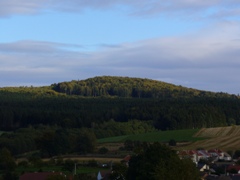
Křemešník is a 769-metre summit in the municipality of Nový Rychnov, in the Vysočina Region of the Czech Republic, close to the town of Pelhřimov. It is the highest point of the Křemešník Highlands (Křemešnická vrchovina), a smaller landscape unit forming the western part of the Bohemian-Moravian Highlands within the wider Bohemian Massif. For generations the hill has served both as a scenic viewpoint and as a pilgrimage destination, and its gentle, forested slopes are popular with hikers and cyclists exploring this part of Vysočina.
Where is Křemešník located?
The summit sits in the southeastern part of the Czech Republic, in the Vysočina Region, within the administrative boundaries of Nový Rychnov. The nearest larger town is Pelhřimov, just a few kilometres away, which makes Křemešník an easy day-trip destination for anyone based in the area. The peak lies at roughly 49.404°N, 15.325°E, right in the heart of the Bohemian-Moravian Highlands, on the historical border between Bohemia and Moravia.
What can you see at the top?
The main draw of Křemešník is the combination of landscape and spiritual significance. On top of the hill stands a well-known pilgrimage complex with a chapel that has drawn visitors and worshippers from across the Vysočina region for generations. The summit is surrounded by extensive mixed and coniferous forest typical of the Bohemian-Moravian Highlands, crossed by a network of marked hiking and cycling trails. Because Křemešník is the highest elevation in the entire Křemešník Highlands, the area around it offers wide views over the rolling countryside, forests and villages of the Vysočina Region.
How do you get to Křemešník?
The most convenient starting point is Pelhřimov, from where marked hiking trails lead up to the summit; the walk typically takes one to two hours depending on the chosen route and pace. By car, you can drive to the villages within the Nový Rychnov municipality and continue on foot or by bike from there, since the summit area itself is subject to restricted vehicle access. The surrounding region is also well connected to cycling routes running through the Bohemian-Moravian Highlands, which makes Křemešník a popular stop on longer cross-country rides through Vysočina.
When is the best time to visit?
Given the forested setting and the summit's role as a viewpoint, spring and summer are the best seasons to visit, when trails are dry and the longer days allow combining the ascent with a longer walk through the surrounding woods. Autumn also has its appeal, as the deciduous parts of the forest add colour that landscape photographers appreciate. In winter the area can be snow-covered and harder to reach, but it remains a rewarding destination for those looking for a quiet, snowy corner of Vysočina — sturdy footwear is recommended at that time of year.
Frequently asked questions
How high is Křemešník? The summit rises to 769 metres above sea level and is the highest point of the Křemešník Highlands.
Which region is Křemešník in? It lies in the Vysočina Region of the Czech Republic, within the municipality of Nový Rychnov, near the town of Pelhřimov, in the Bohemian-Moravian Highlands.
Can you hike up to Křemešník? Yes, marked hiking trails lead to the summit, most commonly starting from Pelhřimov; the ascent usually takes one to two hours.
What is the main point of interest on the summit? A pilgrimage complex with a chapel, along with panoramic views over the surrounding Bohemian-Moravian Highlands.
Nearby places

Earn badges for the places you visit
Download NextOnTrip, discover new places and check off your trails.