About this place
Dubí hora is an elongated, partly forested hill in the Bohemian Uplands (České středohoří), roughly four kilometers northeast of Úštěk in the Litoměřice district of the Ústí region. On its northwestern slope, within the cadastral territory of the village of Konojedy, sits the Dubí hora National Natural Monument, better known by its popular name, Konojedské bochníky — "the loaves of Konojedy." It's a tiny site, just 0.0896 hectares, managed by the Nature Conservation Agency of the Czech Republic (AOPK ČR), but geologically it punches well above its size.
What will you see there?
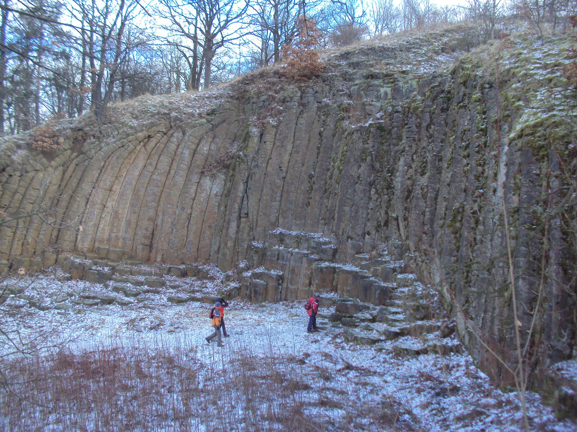
The natural monument is the wall of an old quarry at the eastern edge of Konojedy village. It exposes columns of analcimitic tephrite, a volcanic rock that solidified within an ancient lava flow from Dubí hora. Because this exposed section sits close to what was once the leading edge of that lava flow, it shows a lower degree of erosion than most other neovolcanic outcrops in the Bohemian Uplands — the rock formations here have survived in unusually good condition.
The tephrite columns curve into gentle arches and are crossed by secondary transverse cracks. Rainwater weathering along these cracks has sculpted the columns into shapes that look like loaves of bread stacked on top of each other — hence the nickname. In some column groups, the upper sections narrow and bend in a particularly distinctive way, a feature geologists consider exceptional among Czech neovolcanites.
How do you get there?
Dubí hora isn't served by any marked tourist trail — the only way in is a field path from the village of Konojedy. The easiest approach is on foot or by bike from Úštěk, about 4 km away, heading toward Konojedy and then following the short unmarked track to the old quarry on the hillside. It's worth combining the visit with a longer walk around Úštěk, perhaps pairing it with the town itself or the nearby baroque chateau in Konojedy.
When should you visit?
Spring and autumn are the best times, when vegetation doesn't yet (or no longer) obscure the exposed quarry wall, making the columnar structure easier to appreciate. In summer, denser foliage can partly hide the view, while in winter the field path can be harder to reach after snowfall. Given the site's small size and protected status, it's best to admire the rock wall from a safe distance rather than climbing directly onto it.
Why is it worth a stop?
Konojedské bochníky is one of the lesser-known but geologically fascinating spots in the Bohemian Uplands, offering a compact lesson in how ancient volcanic activity shaped the region's landscape. It appeals mostly to geology enthusiasts, nature photographers, and anyone looking for a quiet, uncrowded detour near Úštěk — no crowds, just an unusual close-up of stone "loaves" carved by nature itself.
Frequently asked questions
Is Dubí hora the same place as Konojedské bochníky? Yes — Konojedské bochníky is the popular name for the Dubí hora National Natural Monument, referring to the bread-loaf-like tephrite columns exposed in the old quarry.
How far is it from Úštěk? The hill lies about 4 km northeast of Úštěk, within the cadastral area of Konojedy village.
Is there a marked trail leading there? No, the site has no marked tourist trail — it's reached via a field path from Konojedy.
What exactly can you see in the quarry? A rock wall of analcimitic tephrite columns, curved into arches and cracked by weathering into shapes that resemble stacked loaves of bread.
Nearby places

Earn badges for the places you visit
Download NextOnTrip, discover new places and check off your trails.