Monuments in Norway
A guide to 36 Monuments in Norway — with descriptions, photos and traveler visits from the NextOnTrip community. Locations spread across 19 cities and towns. Most visited by the community: Olav Tryggvason monument, Madserud gård, equestrian statue of Charles XIV John of Sweden.
-
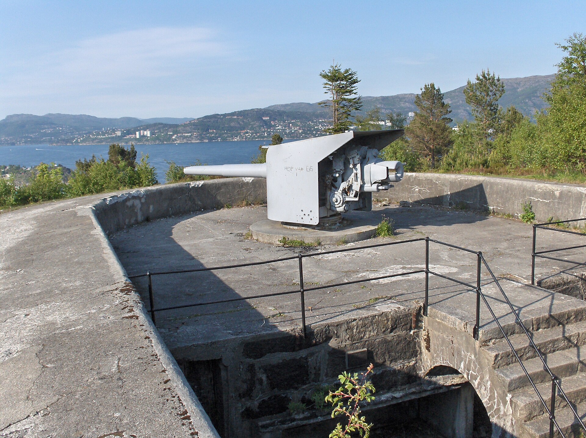
Kvarven Fort
Bergen
Kvarven Fort (Kvarven festning) is a former mountain fortress above the Byfjorden, the main shipping channel leading to Bergen, Norway. Today it is a wooded recreation area with fortification remains and viewpoints. What was Kvarven Fort? The fort stood at a strategic spot where ships approach Bergen from the sea, and it watched over traffic in the fjord. It was a system of defences set into the mountainside rather than a single building. From that position its guns could command the whole waterway leading to the city. When and why was it built? Work began in 1895 and the main installations were finished in 1899. The motive was tension with Sweden before the union was dissolved in 1905, and fear of a naval attack from the sea. A torpedo battery was added by 1902. The union ended peacefully, so the fort never saw action for its original purpose. What happened here in 1940? The real test came in April 1940, during the German invasion of Norway. The Kvarven batteries opened fire on ships entering the harbour, with the vessels "Bremen" and "Carl Peters" among those affected, and the gunners then duelled with the light cruiser "Königsberg". The fort surrendered the next morning after a short fight with German ground troops. During the occupation the Germans expanded and modernised the defences as part of Festung Bergen. What happened to the fort afterwards? It was decommissioned in 1961. In 1993 the area opened as a protected cultural and recreational site, and today it forms part of the Kvarven outdoor recreation grounds. What can you see and do here? Remains of military positions and structures hidden among the trees. Viewpoints over the Byfjorden and surroundings. Forest paths running from the Gravdal side towards Lyderhorn, one of Bergen's seven mountains. Kvarven is also a popular starting point for hikes up Lyderhorn. Frequently asked questions Is the fort still military? No. It was decommissioned in 1961 and has been a recreation and heritage area since 1993. Did the fort see combat? Yes, in April 1940 during the German invasion of Bergen, when its batteries fired on ships entering the port. Who is it for? Anyone who enjoys military history, forest walks and fjord views. Check current access information for individual structures before you go. Can you start a longer hike from here? Yes, trails lead towards Lyderhorn.
-
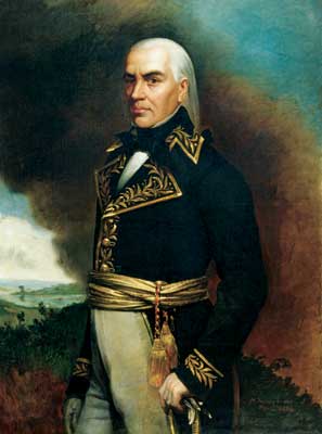
Francisco de Miranda
Petersburg
The Francisco de Miranda monument in Petersburg stands in the Park of the 300th Anniversary of St. Petersburg. It is one of the more unexpected Latin American touches in Russia's northern capital, and it commemorates a Venezuelan revolutionary whose life briefly crossed paths with the city on the Neva in the late 18th century. Who was Francisco de Miranda? Sebastián Francisco de Miranda y Rodríguez de Espinoza was a Venezuelan military leader and revolutionary. He fought in the American Revolutionary War and the French Revolution, and later took part in efforts to free Spain's American colonies. His own plan did not succeed, but he is regarded as a precursor of Simón Bolívar and the other, more successful Libertadores. He is known as the Precursor of Latin American Independence, and in Venezuela he is remembered as the "First Universal Venezuelan" and the "Great Universal American". Why is there a monument in Petersburg? Miranda visited Petersburg in 1787. According to the city's Committee for External Relations, he met Grigory Potemkin here, who introduced him to Empress Catherine II. She granted him the rank of colonel. This visit is the reason the city agreed to host a monument to a hero from the other side of the world. How the monument came about A foundation-stone ceremony took place on 26 November 2010 in the Park of the 300th Anniversary of St. Petersburg, attended by Venezuela's ambassador. The finished monument was unveiled in March 2012. The sculptor is Venezuelan, and the statue was donated to Russia by Venezuelan President Hugo Chávez at the time. It is a gift with a clear diplomatic meaning, symbolising ties between the two countries. What you will see The monument is a full-length figure of Miranda set in a park on the western edge of the city, by the Gulf of Finland. The park was created on the waterfront and is a popular place for walks, so a visit to the statue is easy to combine with a stroll along the shore. A local legend Locals tell a charming story: rubbing the left shoe of the statue is said to bring a calm and happy family life. It is also believed to bless newlyweds, so you may occasionally spot young couples at the monument. As a result, the left shoe of the figure is often noticeably polished. Frequently asked questions Where is the Francisco de Miranda monument in Petersburg? In the Park of the 300th Anniversary of St. Petersburg. When was it unveiled? In March 2012. The foundation stone was laid in November 2010. Who donated the monument? The statue was given to Russia by Venezuelan President Hugo Chávez. What connects Miranda to Petersburg? In 1787 he visited the city, met Potemkin and was received by Catherine II, who gave him the rank of colonel. Is there an entry fee? The monument stands in an open city park, so no ticket is needed to see it. Who is it for? History lovers who enjoy offbeat stories linking distant continents, and visitors exploring the western districts of Petersburg and the Gulf of Finland shore. It is a short, quiet stop that shows how far the story of a Latin American revolutionary reached, all the way to the court of Catherine the Great.
-
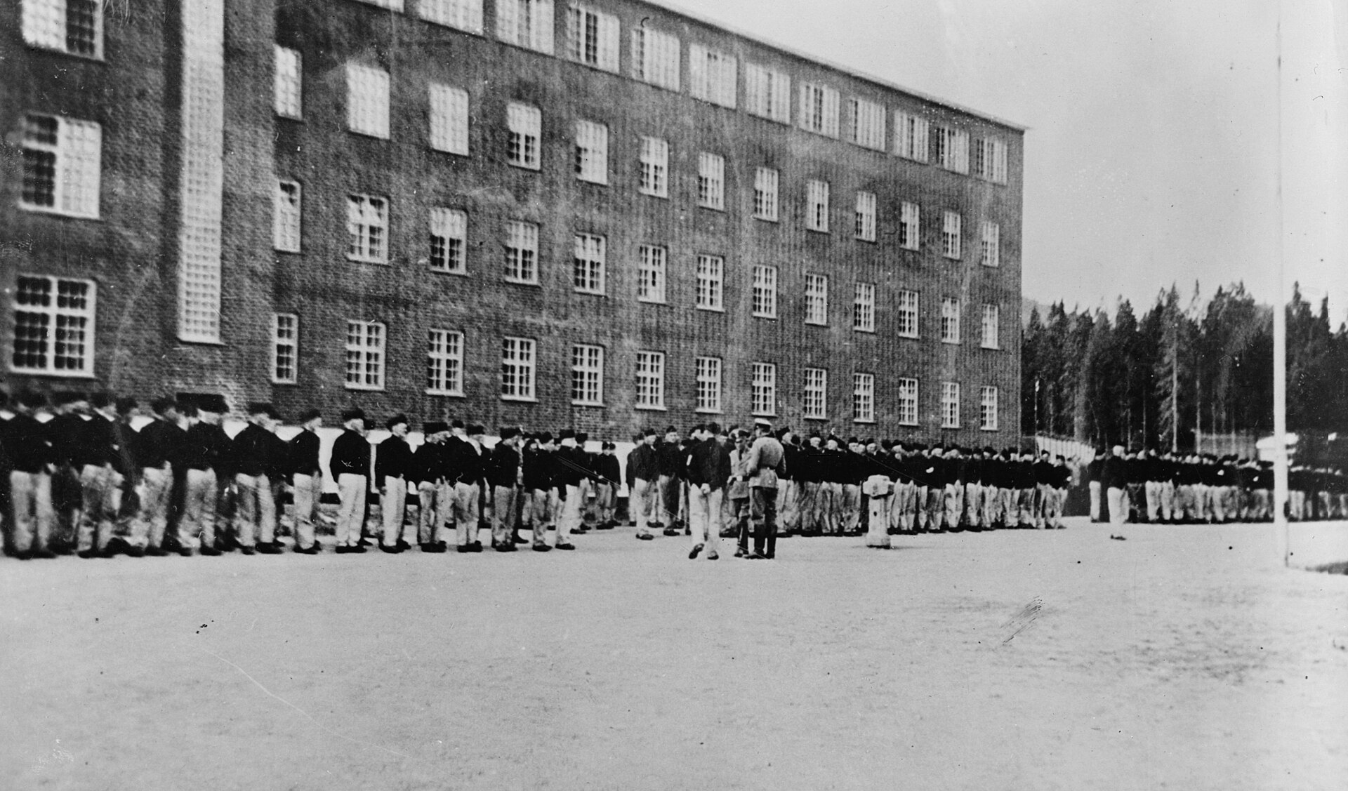
Grini detention camp
Bærum
Grini detention camp was a German police camp in Bærum, just outside Oslo, and between 1941 and 1945 it was the main place of confinement for Norwegian political prisoners under the occupation. Today it is remembered as a World War II site, and the former main building serves as a prison. What was Grini? The large building on the Ila hill was begun in 1938 as a women's prison. After Germany invaded Norway on 9 April 1940, the unfinished complex was taken over by the occupiers. At first Norwegian officers and soldiers were held here; once they were released in June 1940, the building housed Wehrmacht troops. In June 1941 the German security police set up Polizeihäftlingslager Grini. The first 150 men, arrested for anti-German activity, arrived by truck on 14 June 1941. Officially it was a police detention camp rather than a concentration camp, although many prisoners lived through harsh treatment and constant uncertainty about their fate. How many people were held here? As arrests multiplied, the main building became overcrowded. Barracks were added and the camp grew. In total almost 20,000 people passed through Grini, most of them Norwegians held for political reasons. More than 3,400 were sent on to concentration camps in Germany. Close to 800 Grini prisoners died, most after deportation to camps in Germany or German-held territories, while some were executed in the Trandumskogen forest. Liberation and what came next News of the end of the war reached the prisoners on 7 May 1945. The next day, 8 May, the same walls began to hold people suspected or convicted of treason and collaboration. The site was renamed Ilebu prison. What can you see today? The former camp building stands in the Ila district and is now a high-security prison, so it cannot be visited like an ordinary attraction. The story of the camp is kept alive by the Grini Museum (Grinimuseet), which tells about the prisoners and the Norwegian resistance. Frequently asked questions Was Grini a concentration camp? Not strictly. The Germans classed it as a police detention camp, but part of its prisoners were shipped to concentration camps in Germany. When did the camp operate? From June 1941 until May 1945. Can visitors enter the former camp? The old main building is an active prison and is closed to tourists. The museum is the best place to learn about the history. Where is Grini? In Bærum municipality next to Oslo, in the Ila area.
-

Sverresborg
Trondheim
Sverresborg is the remains of a medieval fortress on a rocky hill in Trondheim, tied to one of early Norway's best-known rulers, King Sverre Sigurdsson. Today the ruins sit inside the Trøndelag Folk Museum grounds, so a visit combines castle history with an open-air museum. What was Sverresborg? The fort and royal residence was built in medieval Nidaros, the name Trondheim carried at the time. Sverre Sigurdsson had it raised while he fought rival King Magnus Erlingsson for the Norwegian throne, and the stronghold supported his claim. Norwegian sources date construction to around 1182–1183, and the Norwegian encyclopedia SNL suggests it may be among the country's oldest stone fortresses. A turbulent history The castle was destroyed by enemies twice and rebuilt both times. One of the best-known episodes is the 1197 attack by the Baglers, a faction opposed to Sverre. The events of those years are told in the saga of King Sverre, and archaeology has added a surprising piece of evidence. The discovery in the well In 2014, archaeologists from the Norwegian Institute for Cultural Heritage Research (NIKU) found a skeleton in a well on the site. It matched the saga's account of the 1197 attack, in which a dead man was thrown into a well. It is a rare case of excavation backing up a detail of a medieval story. What you will see today Little of the original fortress survives, mostly stone foundations on the hilltop. Visitors often point out that the views are the main draw, and the walk gives a sense of how strategically the spot was chosen. Treat the visit as a mix of history and scenery rather than a tour of imposing walls. The Trøndelag Folk Museum The ruins are part of the Sverresborg Trøndelag Folk Museum, an open-air museum for the Trøndelag region. Its roots go back to 1909, when volunteers began preserving historic buildings. The site was set aside for the museum around 1914, and it now holds more than 60 buildings. In one visit you can see traces of a royal fortress alongside regional buildings from different periods. Frequently asked questions Is this the same as Sverresborg in Bergen? No. Bergen has a separate fortress with the same name. This description covers the site in Trondheim. Who built Sverresborg? King Sverre Sigurdsson, during his struggle against Magnus Erlingsson for the throne, in Nidaros, today's Trondheim. Are there impressive walls left? No, mostly stone foundations. The appeal lies in the history and the views. Where is the castle? Within the Trøndelag Folk Museum grounds in Trondheim, central Norway. Why does it matter for Norwegian history? It is linked to the twelfth-century fight for the crown, to Sverre Sigurdsson, and to saga events that archaeology has partly confirmed.
-
Klemenskirken i Trondheim
Trondheim
Klemenskirken in Trondheim (St. Clement's Church) is one of the oldest places of worship in the city and one of the most intriguing archaeological sites in central Trondheim. You will not find a traditional church standing here today. Instead, the preserved remains of a medieval church lie in the basement of a modern building at Søndre gate 7-11, near Peter Egges plass. What is Klemenskirken? It is what remains of a medieval church that once stood in Nidaros, the old Trondheim, one of the most important political and religious centres of medieval Norway. The patron saint, Clement, was regarded as protector of sailors, a fitting choice for a harbour town on the Nidelva river. Who built the first church? The tradition is not clear-cut. Local history sources connect the first church with King Olav Tryggvason and the founding of the town around 997. Icelandic sagas, however, point instead to Olav Haraldsson, later St. Olav. Archaeological dating of the earliest church to roughly 1010-1024 fits the second account better. Why does this place matter? According to the Norwegian encyclopedia SNL, one year and five days after Olav fell at the Battle of Stiklestad, his remains were placed above the high altar of this church. They were later moved to Christ Church, the cathedral, which became the focus of the saint's cult and of pilgrimage to Nidaros. Klemenskirken is therefore a notable link in the story of Norway's most important saint. The fate of the church The church burned down in 1344 and was rebuilt. Before 1430, though, it vanishes from written records, and in time people even forgot where it had stood. For centuries its location remained a puzzle for historians. The archaeological discovery Excavations in 2016-2017 at Søndre gate 7-11 uncovered the remains of a building. Researchers at NIKU established that it was a stave church that had been rebuilt several times. The ruins were preserved in place in the basement of a contemporary building, which lets modern architecture sit directly above medieval history. Is the identification certain? Not entirely. A 2022 article in the journal Primitive Tider notes that the site's status as a national monument came about through a process involving the media, church bodies and the state, and that there is no simple one-to-one link between the excavated material and the monument itself. The identification with St. Clement's Church is therefore still debated. Frequently asked questions Where is Klemenskirken? In central Trondheim at Søndre gate 7-11, near Peter Egges plass. Will I see a working church? No. These are preserved ruins in the basement of a modern building, not an active church. Is the site connected to St. Olav? Yes. According to SNL, his remains rested here above the high altar for a time before being moved to the cathedral. When were the remains discovered? During excavations in 2016-2017. Is it worth a visit? Yes, if you are interested in medieval Norwegian history, the cult of St. Olav or urban archaeology. It pairs well with a visit to nearby Nidaros Cathedral.
-
Vebjørn Sand Da Vinci Project
Ås
The Constantinople Bridge (Leonardo da Vinci's design) in Ås is a Norwegian pedestrian and cycle bridge over the E18 highway that brings to life an idea Leonardo sketched more than five centuries ago. It stands about 20 km from Oslo, in the municipality of Ås, and is one of the more unusual engineering structures in this part of Norway. Where does the idea come from? Around 1502-1503, Leonardo da Vinci drew up a plan for a bridge across the Golden Horn in Constantinople, today's Istanbul. The intended patron was Sultan Bayezid II. The design called for a very slender, flat arch roughly 360 metres long, far longer than anything built in that era. The sultan judged the undertaking impossible, and the bridge was never built. Who built the Norwegian version? The sketch was revived by Norwegian artist Vebjørn Sand. After seeing Leonardo's drawing in the mid-1990s, he lobbied the Norwegian public roads authority to carry it out. The architecture came from Selberg Arkitektkontor, with engineers developing the structure. The bridge opened in 2001 and was inaugurated by Queen Sonja. What does the bridge in Ås look like? It is a scaled-down version built from a different material than the original concept. Instead of a stone arch, it uses three glued-laminated timber beams that sweep in an arc over the motorway. It is about 108 metres long, with a longest span of roughly 40 metres. Its distinctive shape, widening toward the supports, keeps the proportions of the Renaissance master's drawing. Can you visit it? The bridge is part of a walking and cycling route over the E18, so it is in everyday use. It makes a good short stop: you can look down on the highway from the deck, and the arch is best appreciated from the side. The coordinates are approximately 59.7189 N, 10.7843 E. Frequently asked questions Is the bridge in Ås the same one planned for Istanbul? No. The Istanbul bridge was never built. The Ås bridge is a scaled realisation of the same idea, in another material and at a much smaller size. Who initiated the project? Norwegian artist Vebjørn Sand, who interested the road authorities in the design. What is it made of? Three glulam timber beams forming an arch over the road. How big is it? About 108 metres long, with a longest span of around 40 metres. Where is it? Over the E18 in Ås, about 20 km from Oslo. For anyone interested in engineering history and architecture, it is a striking example of how a drawing from five centuries ago can finally be realised in another country and with different technology.
-
Kalvebakken bridges
Tromsø
Kalvebakken bridges (Norwegian: Kalvebakken bruer) are a group of three bridges in the municipality of Tromsø, northern Norway, stacked one above another over the same watercourse. Each comes from a different era, which makes the spot a modest but rewarding stop for anyone curious about road history and engineering. What are the Kalvebakken bridges? They are three crossings built decades apart, standing in a single ravine at different levels of the terrain. Together they show how bridge-building technology and the demands placed on the road changed in this part of Norway. From one place you can compare three answers to the same problem: how to carry a road across a stream. The oldest bridge: a stone arch from 1911 The oldest crossing is a stone arch bridge from 1911, located highest in the terrain. The bridge and its associated stretch of old road are protected as cultural heritage. It gives the place its character: a traditional masonry structure recalling a time when traffic here was far lighter and slower than today. The 1958 bridge Further downstream stands a bridge from 1958, built as a cantilever structure with a span of 13 metres. It took over from the old arch as part of the main road and represents another stage in Norwegian road building, when stone gave way to more modern solutions. The 1975 bridge on the E8 The newest of the three dates from 1975 and today forms part of European route E8, which links Tromsø with the south of the region. It is 76 metres long and carries roughly 5,000 vehicles a day. In spring 2024 the Norwegian Public Roads Administration (Statens vegvesen) began replacing the kerbs and railing on this bridge; the contractor was BMO Entreprenør, and a 50 km/h speed limit applied during the works. Completion was planned for 1 September 2024. Who is this place for? Kalvebakken is not a classic attraction with a ticket office, but a curiosity for lovers of architecture, engineering and road history. Keep it in mind if you drive the E8 south of Tromsø and are interested in traces of earlier infrastructure. The 1975 bridge is a live, busy road, so take care when looking around and never step onto the carriageway. Frequently asked questions How many bridges make up the Kalvebakken bridges? Three: a stone arch bridge from 1911, a cantilever bridge from 1958 and a bridge from 1975 on the E8. Which bridge is protected? The oldest one, the 1911 stone arch bridge, is protected as cultural heritage along with its old road. Is the 1975 bridge still used by cars? Yes, it is part of the E8 with about 5,000 vehicles per day. How long is the current E8 bridge? It is 76 metres long. Has the bridge been renovated? Yes, its kerbs and railing were replaced in 2024.
-
Old Town Bridge
Trondheim
Gamle Bybro (the Old Town Bridge) is a wooden bridge in Trondheim that crosses the Nidelva river and links the city centre with the colourful Bakklandet district. It is one of the most photographed views in the city and one of the best-known symbols of Trondheim. Where is Gamle Bybro and how do you get there? The bridge continues from the southern end of Kjøpmannsgata, one of the oldest streets in the city, which runs along the river past former timber warehouses. On the far side lies Bakklandet, a neighbourhood of narrow lanes, low wooden houses and small cafes. From central Trondheim it is a short walk of a few minutes. Crossing takes only a moment, but the view of the river and the waterfront makes it easy to linger. What is the history of the bridge? The first crossing at this spot dates to 1681. It was part of the rebuilding of Trondheim after a great fire, carried out under the plan of General Johan Caspar von Cicignon. The same planner laid out the regular street grid of the city and ordered the construction of Kristiansten fortress, which stands above Bakklandet. The bridge made it easier to travel between the centre and the eastern bank, where the road toward the interior began. The present structure dates from 1861 and was designed by engineer Carl Adolf Dahl. It was built as a timber construction. In the twentieth century the load-bearing parts were reinforced with concrete, yet the bridge still keeps its historic appearance. What is Lykkens portal? The most recognisable feature of the bridge is the carved gateway at its centre, known as Lykkens portal, or the "Gate of Happiness". The portal is a favourite photo spot, especially with the colourful houses of Bakklandet and their reflections in the water behind it. The wooden portals were originally linked to the lifting mechanism of the bridge's movable sections. Can cars use the bridge? No. Car traffic was closed in 2013, when it became clear that the bridge needed a thorough restoration. The work was completed in 2015, and in 2016 the city council decided that the bridge would stay closed to motor vehicles permanently. Today it is used by pedestrians and cyclists, which keeps a walk across calm and safe. When is the best time to visit Gamle Bybro? The bridge looks good in every season. In summer, visitors and residents stroll along the river, and evening light brings out the colours of the facades. In autumn and winter the scene is quieter and the timber structure takes on a more austere character. Photographers do well to come early in the morning, when fewer people are on the bridge. It is also worth viewing it from different sides: from the waterfront on the centre side and from the Bakklandet bank. What else is there to see nearby? After crossing, explore the lanes of Bakklandet, full of small shops, cafes and craft studios. Along the river stand old warehouses built on piles, one of the most characteristic sights in Trondheim. From here it is also an easy walk to Kristiansten fortress, which offers a panorama of the city and the fjord. A stroll around the bridge combines well with a visit to Nidaros Cathedral on the centre side. Frequently asked questions Is there an entrance fee? No. The bridge is a public city crossing and can be used free of charge at any time. Can you cycle across the bridge? Yes, cycling is allowed. Cars are not. How much time do you need? The crossing itself takes a few minutes. With photo stops and a walk around Bakklandet, plan one to two hours. What is the gate in the middle of the bridge called? It is Lykkens portal, the "Gate of Happiness". Who designed the current bridge? Engineer Carl Adolf Dahl, and it was built in 1861.
-
Øverland bro
Haslum
Øverland bro is a historic stone bridge in Bærum municipality, near Haslum, crossing the small river Øverlandselva southeast of the Øverland farm. It is a place where the story of the old roads around Oslo is easy to read: an ancient crossing, dry-stone masonry and a pilgrim route in one spot. What does Øverland bro look like? The bridge is a vaulted structure built of dry-laid stone, meaning without mortar. It is roughly 30 metres long, 3 metres high and 5 metres wide. This technique demanded careful selection and fitting of every block, and the arch holds together through the way the stones are placed. What is the history of the bridge? A crossing has existed here for a very long time. The bridge is already mentioned in Jens Nilssøn's visitation account of 1594, and local sources say it lies at the same old crossing point he used. The stone bridge itself dates from 1838. It was built when Gamle Ringeriksvei, the old road toward Ringerike, was upgraded as a royal road. Earlier, from 1825, the Bergen road had become a postal route, which called for repairs and better crossings along the way. In 1859 the road stopped being the main route toward Ringerike. In 1893, after Gamle Ringeriksvei was improved, traffic was moved to a new bridge slightly further north and the stone bridge fell out of use. In 1954 that newer bridge was replaced by a steel-beam bridge with a concrete deck. Sources do not fully agree on which bridge is the one that survives today, so it is worth checking current information locally before a visit. Why visit? The road has protected status. The Pilgrim's Route, opened in 1997, passes through the area, and footpaths were built down to the bridge on both sides of the river. That makes it easy to reach on foot as part of a walk around Haslum. It suits anyone interested in transport history, stonework and old highways. It is not an all-day attraction, more a quiet, short stop on a walk along the river and the pilgrim path. Frequently asked questions Where is Øverland bro? In Bærum municipality, near Haslum, over the river Øverlandselva, southeast of the Øverland farm. When was the bridge built? The stone bridge dates from 1838. The crossing itself is much older and was mentioned in 1594. Is it part of the Pilgrim's Route? Yes. The Pilgrim's Route, opened in 1997, includes this place, and paths lead to the bridge from both sides of the river. Can you walk there? Yes, footpaths on both sides of the river lead to the bridge. Why did it stop being used? In 1893, after the road was improved, traffic moved to a new bridge slightly further north.
-
Løkke bro
Sandvika
Løkke bro (Løkke Bridge) is the first cast iron bridge in Norway, set over the Sandvikselva river in Sandvika, in the municipality of Bærum. It dates from 1829 and today serves as a footbridge in a green part of town. It is a small landmark, but a significant one for anyone interested in engineering history or in the Impressionist painters. What is Løkke bro? The bridge was assembled from cast iron elements, which was a novelty in Norway in the 1820s. This type of construction allowed a permanent crossing that was more durable than the timber bridges that had previously dominated the area. For that reason it is regarded as a milestone in Norwegian bridge building and is described as the country's first cast iron bridge. Local sources differ on where the iron was cast, so there is no single settled account of that detail. Why visit? The bridge also has an artistic side. In 1895, during a two-month trip to Norway, Claude Monet visited Sandvika. He had come to see his stepson Jacques Hoschedé, who lived in Oslo. The painter depicted the bridge in a canvas that is now held by the Art Institute of Chicago. A walk across it lets you stand where one of the best-known Impressionists found a subject. Where is it and how do you get there? The bridge is in Sandvika, in Bærum, west of Oslo. In 1977 the original road bridge was replaced by a modern structure, and the old one was moved roughly 100 metres upstream. Road traffic now crosses on the new bridge along Elias Smiths vei. The historic bridge links Løkkeparken with Sandvika videregående skole and is used by pedestrians. Its coordinates are approximately 59.893 N, 10.519 E. Frequently asked questions Is Løkke bro really Norway's first cast iron bridge? Yes, that is how it is described in local history sources and reference works. What year is the bridge from? 1829. Can you walk across it? Yes. Since it was moved in 1977 it has served as a pedestrian bridge. Did Monet paint this bridge? Yes, in 1895 during his stay in Sandvika. The painting is in the Art Institute of Chicago. Is the bridge still at its original site? No. It was shifted about 100 metres upstream, and a new road bridge now carries traffic at the old crossing. In short Løkke bro brings the history of technology and the history of art together in one place. It is compact, easy to reach and fits well into a stroll through the park and along the river in Sandvika. For visitors to the Oslo area it makes a short but rewarding stop.
-
Bergen City Hall
Bergen
Bergen City Hall (Bergen rådhus) is a modernist building at Rådhusgaten 10 in central Bergen, in Norway's Vestland region. It stands about 51 m tall with thirteen floors above ground (some sources list fourteen). It was completed in 1974 and has since undergone a thorough renovation. Who designed Bergen City Hall? The architect was Erling Viksjø, who won the architectural competition in 1953. Construction then stretched over two decades, and the building was finished in 1974, after Viksjø's death in 1971. Architecture databases classify it as part of the modern movement. The Nasjonalmuseet collection holds photographs of Viksjø's model and drawings from 1952, a reminder of how long the design took to mature. Is this where the city's ceremonial functions happen? Many visitors expect a historic town hall like those of western Europe. The Norwegian encyclopedia Store norske leksikon describes Bergen's city hall as essentially an office building. The city's representative functions are housed in older, historic buildings: Hagerupgården and Håkonshallen. If you want medieval atmosphere, head there instead, and treat the city hall as a notable example of postwar administrative architecture. What does the building look like, and what changed after 2018? The facade is based on concrete. Over time it began to crumble, and an industry write-up says the building had become a hazard to people nearby. Between 2018 and 2022 it was renovated by the Danish studio Henning Larsen Architects. The project lead says the work gave the building another 50 years of life. The rehabilitation received the BREEAM award in 2024 in the rehabilitation category, recognising the reuse of an existing structure rather than demolition. Where is it and how do you find it? The building stands in the city centre at Rådhusgaten 10, at roughly 60.392 N, 5.328 E. Its height makes it visible from many points downtown, which helps with orientation while walking around Bergen. It is a working administrative building, so touring the interior is not the main point. The best way to see it is from the outside, looking at the massing, the rhythm of the facade and the texture of the concrete. Frequently asked questions When was Bergen City Hall built? The competition was won in 1953 and the building was completed in 1974. Who designed it? Erling Viksjø; the 2018–2022 renovation was carried out by Henning Larsen Architects. Is it a historic-style town hall? No. It is a 20th-century modernist office building; the city's ceremonial functions sit in older buildings, Hagerupgården and Håkonshallen. How tall is it? About 51 m, with thirteen floors above ground.
-
Drammen rådhus
Drammen
Drammen rådhus is the town hall of Drammen in Buskerud, Norway, standing on the square Bragernes torg. Finished in 1871, this red brick building is one of the best-known landmarks of the city centre and a good starting point for a walk around the area. When and why was Drammen town hall built? Construction was completed in 1871. The trigger was a fire in 1866 that destroyed Albumgården, the building the town council had been using. The town needed a new seat, and the answer was a prominent building on Bragernes torg, the main square of the Bragernes district. Who designed it? The architect was Niels Stockfleth Darre Eckhoff. He designed the building in an eclectic manner, popular in the second half of the 19th century, when architects freely combined motifs from different periods. What does the building look like? The town hall is built of red brick. Its style draws on the Renaissance and on medieval castles, which gives the building a slightly fortress-like character. The strong colour of the walls sets it apart from its surroundings and makes it easy to recognise from a distance. What happened to the building in the 20th century? It has not always served as a town hall. For a time it housed the main police station. Later, subsidence problems nearly led to its demolition. In 1966 a proposal to tear it down was put forward, but residents rejected it in a public vote, and the building survived. A thorough restoration followed. According to the Norwegian local history wiki, the work was finished in time for the town's anniversary in 1986, while other sources give 1985 as the reopening date. In 1987 the building received the Europa Nostra award for conservation, a European distinction for heritage protection. Is this the same building as the town hall cinema? Do not confuse it with the neighbouring complex from the 1940s, which contains an administration building and a cinema. It was designed by other architects, including Reidar Winge Lund and the firm Pedersen & Lund with Arne Pedersen. It is a separate, newer structure beside the historic 1871 town hall. Why visit? It is a clear example of 19th-century civic architecture in Norway. The story of its rescue from demolition shows how residents cared for their shared heritage. It stands on Bragernes torg in the heart of town, so it is easy to combine with a walk around the centre. The exterior can be admired at any time; for access to the interior, check with the municipality. Frequently asked questions When was Drammen town hall built? It was completed in 1871. Who designed it? Niels Stockfleth Darre Eckhoff. What is it made of? Red brick, in an eclectic style with Renaissance and medieval castle influences. Was it ever threatened with demolition? Yes, in 1966 demolition was proposed, but residents rejected it in a vote. Did it win an award? Yes, the Europa Nostra award for conservation in 1987.
-
Bærum town hall
Sandvika
Bærum Town Hall (Bærum rådhus) in Sandvika Bærum town hall is the administrative seat of Bærum municipality in Sandvika, Akershus, Norway, a short distance west of Oslo. It is one of the best-known landmarks of Sandvika and a rare example of a municipal building that also works as an art venue. Who designed Bærum town hall? The building was designed by the architect Magnus Poulsson, one of the prominent Norwegian architects of the early twentieth century. The first construction phase was completed in 1927 and consisted of the east wing and a tower 31 metres tall. The tower is neo-Gothic in style and still dominates the surroundings of the building. How did the town hall grow? After the Second World War the municipality needed more space. The wings facing the sea and the Sandvika river were built between 1958 and 1962, and together with the east wing they enclose a courtyard. Poulsson's son Anton continued the work and ultimately completed the building in line with his father's original vision in the 1960s. The result is a complex built in stages over several decades but conceived as a single whole. What was the idea of the "white city"? Magnus Poulsson wanted Sandvika to become a "white city". The town hall was designed in line with this intention, together with other buildings in the centre: Brambanigården, Budstikkagården and the Sandvika cinema. Walking through the centre of Sandvika, you can still read the town hall as part of this larger urban plan rather than as an isolated monument. What can you see inside? The building is known for its decoration and art. One of its most important spaces is the Munthe Room, decorated by the painter Gerhard Munthe. It holds seven paintings by Munthe, originally made in 1916 for a parlour at Lille Reistad in Lier. The municipality began building up its art collection in 1960, at the time the last wings were being completed, and the town hall has since served as a showcase for it. Art-focused tours of the building have been organised in English as well as Norwegian. Practical information Location: Sandvika, Bærum, Akershus; coordinates approx. 59.89 N, 10.53 E. Type of attraction: administrative building, architecture, art interiors. Best for: fans of Norwegian architecture of the interwar and post-war periods, art lovers, and visitors exploring the centre of Sandvika on foot. Nearby: the Sandvika river and the waterfront, to which two of the wings are turned, as well as the other buildings of the "white city" listed above. Frequently asked questions When was Bærum town hall built? The first phase, the east wing with the tower, was completed in 1927. The wings facing the sea and the river followed between 1958 and 1962. Who was the architect? Magnus Poulsson. His son Anton Poulsson finished the building according to the original plan in the 1960s. How tall is the tower? 31 metres. It is built in the neo-Gothic style. What is the Munthe Room? A room decorated by Gerhard Munthe, with seven of his paintings that were originally created in 1916 for a parlour at Lille Reistad in Lier. Is the town hall only an office building? No. Besides serving the municipality, it houses the municipal art collection, which has been built up since 1960, and its interiors are a destination in their own right for visitors interested in art and architecture.
-
Oslo City Hall
Oslo
Oslo City Hall (Norwegian: Rådhuset) is the building where the authorities of Norway's capital have their seat. It is also one of the best-known landmarks in Oslo: a red-brick landmark by the fjord, with an art gallery and the hall where the Nobel Peace Prize is presented every year. What is Oslo City Hall? It is a working municipal building. Inside are the city administration's offices, alongside an art gallery. So it is not just a monument to admire from the outside, but a place where the daily business of the city is carried out. Who designed it and when was it built? The architects were Arnstein Arneberg and Magnus Poulsson. Construction took nineteen years, from 1931 to 1950, and was interrupted by the Second World War. The official opening took place on 15 May 1950. What does the building look like? The structure is reinforced concrete faced with red brick. Its style is described as functionalist, with touches of national romanticism and neoclassicism. The result is a building that feels austere and modern, yet unmistakably Norwegian. What is there to see inside? The interiors are richly decorated. Almost every surface was entrusted to painters: Henrik Sørensen and Alf Rolfsen worked on the main hall, and Per Krohg on the east gallery. The building also shows Edvard Munch's painting "Life" (1910) in a room named after him. For visitors, this means a trip to city hall feels like a walk through a museum of early twentieth-century Norwegian art. Allow at least an hour if you want to take in the murals and paintings in the main hall and the galleries at a relaxed pace. City Hall and the Nobel Peace Prize Oslo City Hall hosts the Nobel Peace Prize ceremony every year, held in the building's main hall. According to some sources it has taken place here since 1990; before that, laureates received the prize in the university's aula. As a result, the name of the building appears in news around the world each December. How to plan a visit City Hall stands in central Oslo by the fjord, so it combines easily with a walk along the nearby waterfront. Because it is a working administrative building, opening hours and entry rules can change, particularly around the Nobel ceremony. Check current information on the city's official website before you go. Frequently asked questions Is Oslo City Hall really used by the city government? Yes, it is the seat of the city authorities and contains office space. Who designed it? Arnstein Arneberg and Magnus Poulsson. When did it open? On 15 May 1950, after nineteen years of construction interrupted by the war. Is the Nobel Peace Prize awarded here? Yes, the ceremony takes place every year in the main hall. Is there an art gallery? Yes, the building houses a gallery, and the interiors themselves are covered with works by Norwegian painters.
-
Steilneset Memorial
Vardø
Steilneset Memorial in Vardø is a monument to the victims of the 17th-century witch trials, set in Finnmark, in Norway's far north. It was designed by architect Peter Zumthor and artist Louise Bourgeois and opened in 2011. For Bourgeois it was the last major work of her career. What does the memorial commemorate? The monument remembers 91 people condemned and executed for witchcraft, most of them burned at the stake. One source puts the numbers at 77 women and girls and 14 men. The idea began in 2000, when Vardø Municipality was establishing the Millennium Site and decided to build a memorial to the victims. It stands near the assumed execution site, with a view of the old church and the fortress. What will you see? The memorial has two separate parts. Zumthor's structure. The first building is a pine scaffolding frame holding a suspended fabric cocoon. Inside runs a long corridor with an oak floor. Along it are 91 small windows, each with a light bulb hanging behind it and a plaque telling the story of one victim. Walking the corridor means reading the stories one after another. Bourgeois's installation. The second part is Louise Bourgeois's piece The Damned, The Possessed and The Beloved, housed in a separate smoked-glass building. It was her last major installation before her death. Why visit? Steilneset joins architecture and contemporary art with a difficult chapter of the region's history. The place is quiet and reflective, and the row of 91 lights in a single corridor shows the scale of the tragedy without needless drama. It suits visitors interested in modern architecture, Norwegian history, and the work of Zumthor and Bourgeois. Vardø lies at the north-eastern edge of Norway, in Vardø Municipality, Finnmark. The memorial pairs well with a walk around the area and a visit to the fortress, which can be seen from the memorial grounds. Frequently asked questions Where is Steilneset Memorial? In the town of Vardø, Vardø Municipality, Finnmark, Norway. Who designed it? Peter Zumthor designed the corridor structure, and Louise Bourgeois created the installation in the glass building. When did it open? In 2011. How many people does it commemorate? 91 people executed in witch trials in the 17th century. Each has a window and a plaque telling their story. What do the lights in the corridor mean? Each of the 91 bulbs hangs behind a window dedicated to one victim, forming a row of lights of remembrance. Was this Louise Bourgeois's last work? Yes, it was her last major installation before she died.
-
Sinimäed monument
Sinimäe alevik
Sinimäed monument is a war memorial in north-eastern Estonia, near the village of Sinimäe, a short drive west of Narva. It commemorates the soldiers who fell in the fighting for the Blue Hills in the summer of 1944 and is one of the best-known World War II memorial sites in this part of the country. Where is it and what does it look like? The complex stands on the western slope of Grenaderimägi hill, close to the old Vaivara cemetery. A steel cross about 12 metres tall dominates the site. It was designed by the artist and blacksmith H. Müller and carries a composition depicting an explosion at its centre. The memorial was completed in 2000. The first marker in the Blue Hills area was a 6.5-metre wooden cross erected in 1994. More monuments followed nearby: one to the 20th Waffen Grenadier Division in 2004, and two years later memorials to the Dutch and Walloon volunteers. What happened at the Blue Hills? The Blue Hills (Estonian: Sinimäed) are three small hills west of Narva. In summer 1944 the German defensive position known as the Tannenberg Line ran through them. The battle lasted from 24 July to 10 August 1944, although some sources date its start to 26 July, when Red Army units reached the hills. Figures differ between accounts. One version says some 22,000 German, Estonian, Danish, Flemish, Norwegian and Dutch troops defended the hills against Soviet forces that initially numbered around 137,000. Why is the place sensitive? Toomas Hiio of the Estonian War Museum notes that it was the first time since the occupation of Estonia in 1940 that Estonians opposed the Red Army on such a scale. He also argues that popular histories have somewhat exaggerated the Estonian contribution. Memory of the battle remains a delicate subject in Estonia and the wider region, since many of the fighters served in German formations, and interpretations are contested. In May 2023 vandals defaced three memorials in the Blue Hills. Estonia's Internal Security Service has also said that Russian intelligence services were recruiting people for provocations around commemorations. Is it worth a visit? It suits visitors interested in military history and the recent past of Eastern Europe. It is a memorial rather than a museum or a typical tourist attraction, so quiet, respectful behaviour is expected. The site pairs well with a visit to Narva and its border fortress on the river. Frequently asked questions Where is the Sinimäed monument? In north-eastern Estonia, in Ida-Viru County, on the western slope of Grenaderimägi hill near Vaivara, west of Narva. What does it commemorate? Soldiers killed in the Battle of the Blue Hills in July and August 1944 on the Tannenberg Line. How big is the main cross? The steel cross is about 12 metres tall, with an explosion composition at its centre. When was it built? The first wooden cross was raised in 1994 and the current memorial was completed in 2000. Further monuments were added in 2004 and 2006. Is there an entrance fee? Available sources do not indicate any fee; it is an open-air memorial site.
-
Abel Monument, Royal Palace Park, Oslo
Oslo
The Abel Monument in the Royal Palace Park, Oslo honours Niels Henrik Abel, the Norwegian mathematician, with a bronze sculpture standing on a small mound in front of the Royal Palace. It is the work of Gustav Vigeland, the sculptor behind Oslo's famous sculpture park, and it sits in a green corner of the city centre, a short stroll from the park's paths. Who was Niels Henrik Abel? Abel (1802-1829) is one of Norway's greatest mathematicians. He lived only a short life, yet he managed to show that the general fifth-degree equation cannot be solved using radicals. Today his name lives on in the Abel Prize, awarded since 2002 for outstanding achievements in mathematics. What does the monument look like? The bronze stands on a rise known as Abelhaugen. Instead of a conventional portrait of a scholar with a book or compass, Vigeland chose movement and energy. The Vigeland Museum describes the work as conveying the power of the mind through dynamism rather than traditional attributes. A youthful figure strides over two bowed figures, usually read as ignorance or adversity overcome. With its base, the monument is roughly 12 metres tall. Not everyone was convinced. The German mathematician Felix Klein described a young athlete striding over two victims and thought the design would disappoint anyone who knew Abel's character. Despite that criticism, the sculpture is regarded as Vigeland's breakthrough and led to further major commissions. When was it unveiled? Sources disagree on the year. Most give 1908, while the Vigeland Museum's text points to 1911. It is safest to say the monument was unveiled in the early twentieth century. Why visit? It links two stories: the history of science and the art of Vigeland, making it a natural stop before visiting Vigeland Park. It lies in the Palace Park in the city centre, so it fits easily into a walk around the Royal Palace. Each year a wreath-laying ceremony connected with the Abel Prize takes place at the monument. Frequently asked questions Who designed the Abel Monument in Oslo? Gustav Vigeland, the Norwegian sculptor. Where exactly is it? In the Palace Park, on the Abelhaugen mound in front of the Royal Palace in Oslo. Is there an entrance fee? The monument stands in a public park, so you can see it during a walk. What do the figures at Abel's feet represent? Two bowed figures, traditionally interpreted as obstacles overcome. Vigeland aimed to show the power of the mind in motion rather than a literal account of the mathematician's life. Is this Vigeland's only sculpture in Oslo? No. His best-known work is the sculpture park, which is well worth seeing on the same visit. Visiting tip Come during the day, when the park is full of walkers and the sculpture can be seen from several sides. The best view is from the path below, where you can see the figure rising above the bowed forms.
-
The Saga Column
Lom
The Saga Column (Sagasøyla) is a monumental sculpted column in the Leirdalen valley, in the municipality of Lom, beside the Sognefjellsvegen road in Bøverdalen. It stands roughly 33 to 34 metres tall and is one of the most unexpected landmarks in the Norwegian mountains. It was designed by the sculptor Wilhelm Rasmussen. Where does the Saga Column come from? The column began as a design for a monument to the Constitutional Assembly at Eidsvoll in 1814, when Norway's constitution was adopted. Rasmussen won a 1925 competition for the work, originally titled Eidsvollsøylen. It was meant to stand in Oslo, on Eidsvolls plass in front of the Storting. Why isn't it in Oslo? The plan was never carried out in the capital. Rasmussen joined Nasjonal Samling in 1933, and after the war, completing the work was shelved. For years the column was not erected on the site it had been designed for. How did it end up in Lom? Åmund Elveseter, owner of the Elveseter hotel, bought the column and put it up beside the hotel in 1992. One of Rasmussen's largest works thus found a home far from its original plans. Sources differ on some details, such as the exact height and how much of the work was finished before it was raised, so treat the figures as approximate. Material and form According to the Norwegian encyclopedia SNL, the column is made of larvikite, an igneous rock associated with Norway. Its slender vertical form makes it visible from a distance against the mountains and the valley. What to know before you visit Location: near the Elveseter hotel in Leirdalen, on Sognefjellsvegen in Bøverdalen (Lom). Coordinates: about 61.704 N, 8.287 E. Best for: fans of public art, Norwegian history and short stops on a drive over Sognefjell. Historical context: the work links the 1814 constitution with the controversial biography of its creator, which gives visitors plenty to think about. Frequently asked questions Is the Saga Column in Oslo? No. Although it was designed with Oslo in mind, it was only erected in 1992, at the Elveseter hotel in Lom. Who made it? Wilhelm Rasmussen, a Norwegian sculptor who won the 1925 competition. How tall is it? Sources give 33 to 34 metres. What does it commemorate? It was originally meant to commemorate the Constitutional Assembly at Eidsvoll in 1814. What is it made of? Larvikite, according to the SNL encyclopedia. The Saga Column makes a good stop for anyone crossing Sognefjell who enjoys history and outdoor art. Its story shows how a monument designed for a capital city can end up, decades later, in an entirely different mountain setting.
-
equestrian statue of Charles XIV John of Sweden
Oslo
The equestrian statue of Charles XIV John stands in the heart of Oslo, in front of the Royal Palace, where the city's main promenade, Karl Johans gate, meets the square of Slottsplassen. It is one of the best-known monuments in the Norwegian capital and a natural landmark on any walk through the city centre. Who does the statue depict? The bronze shows Charles XIV John, born Jean-Baptiste Bernadotte, a former French marshal who became crown prince of Sweden in 1810 and took the throne of Sweden and Norway in 1818. He reigned until his death in 1844 and was the first monarch of the Bernadotte dynasty. In Norway he is nowadays usually called Charles III John, because Norwegian regnal numbering is counted differently. On the monument the king wears military dress and holds a commander's baton raised in the air. Who made it, and when? The sculptor was the Norwegian artist Brynjulf Bergslien, and the statue was unveiled in 1875, more than thirty years after the king's death. Older travel handbooks note that the pedestal carries the king's motto, which speaks of the people's love as his reward. Where exactly is it? The statue stands on a rise in front of the palace, at the end of Karl Johans gate. The street was named after the king in 1852, shortly after his death, so the monument and Oslo's most famous boulevard share the same name. Behind the rider lies Slottsparken, the public park around the palace, which holds other monuments too. The coordinates are roughly 59.9167 N, 10.7290 E. How to visit The best way to see it is on a stroll along Karl Johans gate: from the central station the promenade runs uphill toward the palace, and the king on horseback closes the view at the end of the street. It is easy to combine with a walk through the palace park and a look at the facade of the Royal Palace. The monument sits in an open public space, so there is no admission, and it makes a good photo spot with the palace in the background. Frequently asked questions Is there an entrance fee? No, the statue stands in an open public area. Who made the sculpture? Brynjulf Bergslien. When was it unveiled? In 1875. Why is the street called Karl Johans gate? It was named in 1852 in honour of the recently deceased King Charles John. Is Charles III John the same king? Yes. Sweden uses the number XIV, while Norway today uses III.
-
Olav Tryggvason monument
Trondheim
The Olav Tryggvason monument stands in the middle of Trondheim's main square, Torvet, where the streets Munkegata and Kongens gate meet. It is one of the most recognisable landmarks in the city centre and a natural starting point for a walk through the old town. Who was Olav Tryggvason? Olav Tryggvason was a Viking-age king of Norway who ruled in the late 10th century and died in the year 1000 at the Battle of Svolder. Norwegian tradition regards him as the founder of the town known in the Middle Ages as Nidaros, today's Trondheim. That is why the city placed a monument to him right at its heart. He is also associated with strengthening Christianity in the country. What does the monument look like? The sculpture shows the king standing on top of a tall column, and the whole structure is roughly 18 metres high. Norway's national encyclopedia classes this kind of monument as an "æressøyle", an honour column: a freestanding pillar crowned with a statue, a tradition that goes back to antiquity. The sculptor was Wilhelm Rasmussen, and the monument was unveiled in 1921. According to a local history wiki, the merchant Dyre Halse paid for it. A sundial at the foot of the column The paving around the base is worth a look. A cobblestone mosaic from 1930 works as a giant sundial, with the column itself casting the shadow. The dial is set to UTC+1, so in summer, when daylight saving time applies, it reads an hour behind your watch. Keep that in mind if you plan to tell the time by the shadow. What to see nearby Torvet is Trondheim's central square and an easy base for exploring on foot. Munkegata, the street the monument stands on, is one of the main axes of the city. Most sights of the old centre are within walking distance, and you will find cafés and restaurants in the nearest blocks. Frequently asked questions Where exactly is the Olav Tryggvason monument? On Torvet square in central Trondheim, at the junction of Munkegata and Kongens gate. How tall is it? About 18 metres, counting the column and the statue of the king. When was it unveiled? In 1921. The sculptor was Wilhelm Rasmussen. Does the sundial show the exact time? It is set to UTC+1, so in summer it shows one hour earlier than local clock time. Is there an entrance fee? No. The monument stands in an open city square and can be seen at any time. Why does the monument matter to the city? It commemorates the king regarded as the founder of Trondheim, so it symbolises the city's beginnings.
-
Fredslunden
Molde
Fredslunden ("Peace Grove") is a small memorial park in Molde, western Norway, located in the Glomstua area right beside the famous Kongebjørka, the Royal Birch. It was inaugurated in 1997 as a place that recalls freedom, peace and human dignity. What is Fredslunden? This is a quiet corner rather than a ticketed attraction with queues. The park was conceived as a symbol of the ongoing struggle for freedom, peace and human dignity. That is why it sits next to the Royal Birch, which Norwegians came to regard as a sign of resistance to the Nazi occupation during the Second World War. The two sites are best seen together on a single walk. What is the story of the Royal Birch next door? The original tree was destroyed by vandals in 1981. A year later, in 1982, King Olav V planted a new birch. This gives the ground around Fredslunden real historical and symbolic weight, and the park is a natural companion to that story. What makes the trees here special? The main curiosity is that the trees were planted by well-known figures. A plaque on site records that between 1997 and 2004 eight trees were planted by writers and public figures. Those named include: Wole Soyinka, the Nigerian writer and Nobel laureate, Seamus Heaney, the Irish poet, Vigdís Finnbogadóttir, former President of Iceland, Thor Heyerdahl, the explorer, Hans Blix, the Swedish diplomat. The plaque was put up by the Bjørnson Festival, the literary festival associated with Molde. Each tree is a small monument to people who combine writing, public life and commitment to peace. How to visit Fredslunden Plan a short stop for an unhurried walk and a read of the plaque. The park suits quiet reflection rather than active recreation. It pairs well with a visit to the Royal Birch, and both fit easily into a route around Molde, the town known as the "City of Roses" and of festivals. Travel listings give the address as Glomstuvegen 50, 6412 Molde. Frequently asked questions Where is Fredslunden? In Molde, in the Møre og Romsdal region of Norway, in the Glomstua area next to the Royal Birch. When did the park open? In 1997. Who planted the trees? Between 1997 and 2004, eight writers and public figures planted them, including Wole Soyinka, Seamus Heaney, Vigdís Finnbogadóttir, Thor Heyerdahl and Hans Blix. What does the park symbolize? The continuing struggle for freedom, peace and human dignity. Is it a major attraction? No, it is a quiet, symbolic memorial park. See it together with the Royal Birch, without rushing, and take a moment at the plaque naming the tree planters.
-
Madserud gård
Oslo
Madserud gård is a former farm estate in western Oslo, at Madserud allé 34 in the Skøyen district. Today it is best known as an early twentieth-century manor surrounded by greenery, a reminder of the time when this part of the city was still rural. Where is Madserud gård? The estate lies in the west of the Norwegian capital, in Skøyen, close to Frognerparken and the Vigeland Museum. The building sits at roughly 59.924° N, 10.695° E. The surroundings are quiet and green, and the trip from the city centre is short. How did the name and the history begin? The beginnings were modest. The place started out as a tenant smallholding belonging to the larger Søndre Skøyen property. Its name comes from Mads, the father of a man called Niels Madsen. Over time the small holding grew into a stately estate. Who owned it? In 1812 the property passed to the merchant Jacob Erasmus Dybwad. Harald Løvenskiold bought it in 1903, and in 1913 the main house was enlarged to a design by the architect Herman Backer. That rebuilding gave the house the symmetrical form it still has. The Mustad and Munch connection From the mid-1920s the manor was home to Christian Mustad, the fish-hook manufacturer, who was its last residential occupant. In 1937 he and his wife donated six large paintings by Edvard Munch to the National Gallery in Oslo. This is one reason the Madserud name appears in Norwegian cultural history. What was the building used for later? After its residential era, the building housed a TV studio, an art gallery and a restaurant. In 2009 the company Selvaag tried to sell it with an asking price of around NOK 100 million, but the sale stalled. In 2022 the ORO group bought the property, intending to use it as offices. Can you visit Madserud gård? The building is in commercial use, so it is not a museum with regular opening hours. It works best as an architectural stop: from outside you can see the symmetrical main house and the character of the old estate. Check current access information before you go. Frequently asked questions Where exactly is Madserud gård? At Madserud allé 34 in the Skøyen district, in western Oslo. Who designed the current form of the house? The 1913 enlargement was designed by the architect Herman Backer for Harald Løvenskiold. Why does the manor matter culturally? Christian Mustad lived here, and in 1937 he donated six large Munch paintings to the National Gallery. Is it still a private residence? No. After serving as a studio, gallery and restaurant, it was bought in 2022 by the ORO group for office use. What is nearby? Frognerparken and the Vigeland Museum are a short distance away, so a visit combines easily with a walk through this part of the city. Madserud gård suits visitors interested in architecture, the history of Norwegian estates and the link between art and private patronage. It is not a large attraction, but it shows how Oslo's former rural hinterland changed as the city grew.
-
Ulefos Hovedgaard
Ulefoss
Ulefos Hovedgaard is a historic manor house in the village of Ulefoss, in Nome municipality, Telemark, Norway. Its main building is regarded as the finest example of an Empire-style manor house in the country, and it is one of the most important traces of the Aall family, who shaped the area for generations. What is the history of Ulefos Hovedgaard? The farm was first mentioned in 1439 under the name Wolufos. Around 1550 it was taken over by Claus Huitfeldt, and it became a noble estate exempt from tax. Over the 18th century it passed between owners from merchant and industrial circles. In 1782 Nicolai Benjamin Aall bought out the heirs of Christian Ancher and became owner of the whole farm. From then on it stayed in the Aall family. At first they used it as a summer home, and from 1830 they lived there all year round. When was the main building constructed? The present stately building dates from the early 19th century. Sources differ slightly on the exact years, but point to roughly 1802 to 1807, with the commission coming from ironworks owner Niels Aall. Construction took several years. The result is an elegant, symmetrical Empire-style house, a style that in Norway is associated with the wealthy merchant and industrial families of the period. Why is the manor in Ulefoss? The village is known for the Ulefos ironworks, founded in 1657. It is considered the oldest industrial enterprise in Norway and is still in operation. The manor was the seat of a family tied to that industry, so it is worth seeing together with its surroundings, where economic history and architecture are closely linked. Who owns it today? The main building and park have belonged since 1943 to the foundation Statsråd Niels Aalls Minde. Aall descendants still own the surrounding forest land. Today the manor is operated by Telemark Museum, so it can be visited as part of the regional museum offering rather than only admired from outside. How to plan a visit Ulefoss lies in Nome municipality in south-eastern Norway. The manor stands near the centre of the village, surrounded by a park that suits a quiet walk. The coordinates are about 59.29° N, 9.25° E. Opening hours and visiting rules change by season, so check current information with Telemark Museum before you travel. Frequently asked questions Where is Ulefos Hovedgaard? In Ulefoss, in Nome municipality, Telemark county, south-eastern Norway. What style is the manor? Empire. It is considered the best example of that style among Norwegian manor houses. Who built the main building? It was commissioned by Niels Aall, owner of the Ulefoss ironworks, in the early 19th century. Who manages the site now? It is owned by the foundation Statsråd Niels Aalls Minde and operated by Telemark Museum. Can I combine the visit with other sights? Yes. Nearby you will find the old ironworks and other traces of the village's industrial history, which help explain where the Aall family's wealth came from.
-
22 July Information Center
Oslo
The 22 July Information Center (Norwegian: 22. juli-senteret) is a learning centre in Oslo dedicated to remembering the terror attacks of 22 July 2011 and sharing knowledge about them. It stands in the city centre at Teatergata 10, close to the government quarter. Admission is free. What is this place? The centre works with the mediation of memory and knowledge about the attacks in Oslo and on the island of Utøya. It is not a traditional museum filled with display cases, but a space for learning, conversation and reflection. It shows what happened that day, how society has talked about it, and how victims and survivors are remembered today. What happened on 22 July 2011? On that day a bomb exploded in the government quarter of Oslo, and the perpetrator then attacked participants at a youth camp on Utøya. Seventy-seven people were killed, most of them young people. It was the deadliest attack in Norway since the Second World War. The events deeply affected the country and remain an important reference point in Norwegian public debate. What will I see in the exhibition? The permanent exhibition is titled "The Public Conversation About 22 July". It includes a timeline of the attack on 22 July 2011 and seven narratives about the events, presenting them from different perspectives. The centre's website also carries witness testimonies. Temporary exhibitions are held from time to time, for example "Your words are important" in 2024. How long to spend and who is it for? The subject is difficult, so allow time to go through the exhibition calmly. It is designed mainly for visitors over 14. Younger children also need information and answers about the attacks, but a conversation with a parent or guardian matters most in that case. Pushchairs, trolley cases and large bags are not allowed inside, so it is best to bring as little as possible. Getting there The centre sits in the middle of Oslo, a short distance from the high-rise government building, and is easy to reach by public transport. Buses 37 and 33 and trams 70, 11, 17 and 18 serve the area. From most places in the city centre you can also walk. Frequently asked questions Is admission free? Yes, entry is free. Where exactly is the centre? At Teatergata 10, 0180 Oslo, in the city centre. Are the opening hours fixed? Opening days and hours have changed over time, so check the official website, 22julisenteret.no, before you go. Is it worth visiting on a short trip to Oslo? Yes, if you want to understand one of the most significant events in recent Norwegian history. The place calls for attention and respect, and it gives a sober picture of how the country handles the memory of the tragedy. Is there material for visitors who do not speak Norwegian? The centre runs an English version of its website, and the exhibition is meant to be accessible to international guests as well. Confirm details before your visit. Practical tips Plan the visit for a quieter time of day and avoid squeezing it into a tight schedule. Keep quiet and be respectful, as many visitors are moved by personal stories. Afterwards, consider a walk through the nearby government quarter, where the first of the attacks took place.
Earn badges for the places you visit
Download NextOnTrip, discover new places and check off your trails.