Save this place and discover nearby attractions with NextOnTrip
In the app you can add it to your favorites, see what else is worth visiting nearby on the map, and earn a badge for your visit.
The app is available for iPhone and Android.
About this place
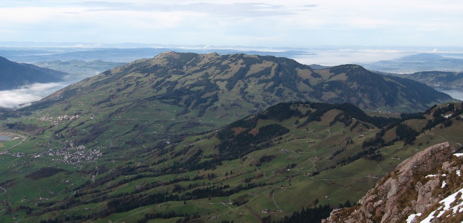
Rossberg is a mountain massif in the Schwyzer Alps that rises above Unterägeri and Lake Ägeri in central Switzerland. It runs along the border between the cantons of Zug and Schwyz, and its high point, the Wildspitz, stands at 1,580 m (Zug Tourism lists 1,579 m). That makes it the highest summit in the canton of Zug and one of the region's best viewpoints.
What will you see on the Rossberg?
From the Wildspitz you look down on three lakes at once: Zug, Lauerz and Ägeri. On the Schwyz side the valley with Lake Lauerz opens up, while the Zug side gives you the lakeland around Lake Zug and Ägerisee. Many walkers time the climb for sunset. A mountain inn near the top offers a place to rest after the ascent.
The Rossberg is one of the three legendary mountains of canton Schwyz, together with the Rigi and the Mythen. The Schwyzer Höhenweg links them, so the ridge often forms one stage of a longer trek.
How do you get up from Unterägeri?
A marked trail leads from Unterägeri to the Wildspitz. The popular Zugerberg – Wildspitz – Unterägeri circuit covers 20.6 km with about 860 m of climbing and takes roughly 6 hours 20 minutes. Plan it as a full-day outing with good fitness.
Other approaches start in Zug, Oberwil, Walchwil, Sattel and Steinerberg. Roads end at Steinerberg, and PostBus serves Steinerberg and Sattel. One classic route begins at Sattel-Ägeri station, climbs the southeast flank via Halsegg to the ridge, passes the Wildspitz and drops to the Gnipen. That descent includes a steep stretch secured with chains and steps, so sure footing and sturdy boots matter.
What happened here in 1806?
The mountain is tied to one of Switzerland's worst natural disasters. On 2 September 1806 a mass of conglomerate rock (nagelfluh) broke away near the Gnipen. The federal inventory puts the volume at about 36 million cubic metres. The slide buried almost all of the village of Goldau and killed 457 people. Sensors have monitored the slope since 1990, and hikers can make a detour toward the detachment zone.
When should you go?
Pick the snow-free months, usually late spring through early autumn. Choose a clear day, since the views are the main reward. Leave enough daylight for the descent, especially if you want to catch the sunset from the summit.
FAQ
How high is the Rossberg?
Its high point, the Wildspitz, is 1,580 m above sea level according to Wikipedia and 1,579 m according to Zug Tourism. It is the highest peak in canton Zug.
How long is the hike from Unterägeri?
The Zugerberg – Wildspitz – Unterägeri circuit takes about 6 hours 20 minutes, covering 20.6 km and 860 m of ascent.
Can you drive to the summit?
No. The road ends at Steinerberg and the rest is on foot. PostBus runs to Steinerberg and Sattel.
Which lakes can you see?
Lakes Zug, Lauerz and Ägeri are all visible from the top, and the Schwyz valley opens up in clear weather.
Nearby places

Earn badges for the places you visit
Download NextOnTrip, discover new places and check off your trails.