About this place
Chrástenský vrch is a modest but geologically interesting hill in the municipality of Osečná, in the Liberec district, rising to 452 metres above sea level. It sits within the cadastral territory of the hamlet of Chrastná, roughly 1.5 km southeast of the village of Břevniště, and belongs to the Ralská Uplands — specifically their Podještědí sub-region. It's a destination for hikers after a quiet forest walk with a dash of local mining history, not for anyone chasing sweeping panoramas.
How do you get to Chrástenský vrch?
The easiest approach is by car to Chrastná itself, or to the crossroads known as "Chrastná – U Potůčku" on the road connecting Osečná and Břevniště. From there the rest is on foot: a green-marked hiking trail heads southeast toward the Ploučnice river and leads directly up to the hill. The route is short and not technically demanding, making it a good fit for families and anyone after a pleasant stroll rather than a serious climb.
It's worth planning the visit around nearby attractions, since the summit itself is more of a short stop than a destination on its own.
What will you find at the top?
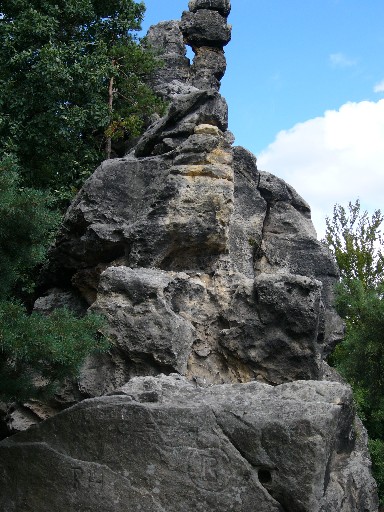
The defining feature of Chrástenský vrch is the exposed rock at its summit, which still bears traces of historical iron ore (limonite) mining. That geology — rather than any view — is the main reason to make the detour. The hill is covered in mature trees that effectively block the surrounding panorama; there's no lookout tower or open viewpoint here, so don't expect the wide vistas some other hills in Podještědí offer.
For anyone interested in geology or mining history, though, it's a worthwhile stop: the mining traces are a tangible record of past industrial activity in the region, when local limonite deposits were worked on a smaller scale than in the better-known mining centres nearby.
What else can you combine it with?
Just below the hill, along the red-marked trail running from Hamr na Jezeře to Osečná, lies the Chrastenský vodopád — a small but scenic waterfall popular with both hikers and cyclists passing through this part of the Ralská Uplands. It's a natural extension of a visit to the summit and a good reason not to turn back right after the top.
Nearby you'll also find the Chrastenský rybník, a recreational and fishing pond that underwent a thorough reconstruction in 2006. It's a peaceful spot to rest after the walk, popular with anglers and anyone looking for quiet time by the water, away from the busier tourist hubs.
When is the best time to visit?
Because the trail runs through forest and there are no open viewpoints, Chrástenský vrch is best visited in spring or autumn, when the trees aren't in full leaf and the rock outcrops and terrain are easier to make out. In summer the route offers welcome shade, making it a solid choice on hot days, while in winter the forest paths can get slippery or harder to walk.
Frequently asked questions
Is there a view from Chrástenský vrch? No — the summit is covered in mature trees that block the surrounding panorama. It's better suited to geology enthusiasts and quiet forest walks than to anyone after a view.
How high is Chrástenský vrch? The hill reaches 452 metres above sea level and belongs to the Ralská Uplands, specifically their Podještědí sub-region.
What are the traces visible on the summit rocks? They're remnants of historical iron ore (limonite) mining once carried out in the area on a small scale.
What's worth seeing nearby? Close to the hill you'll find the Chrastenský vodopád (a waterfall on the red trail between Hamr na Jezeře and Osečná) and the Chrastenský rybník, a recreational fishing pond reconstructed in 2006.
Nearby places

Earn badges for the places you visit
Download NextOnTrip, discover new places and check off your trails.