Monuments in France
A guide to 1358 Monuments in France — with descriptions, photos and traveler visits from the NextOnTrip community. Locations spread across 956 cities and towns. Most visited by the community: Château de la Bretonnière, Château de Caumont, Château du Petit-Arnsberg.
-
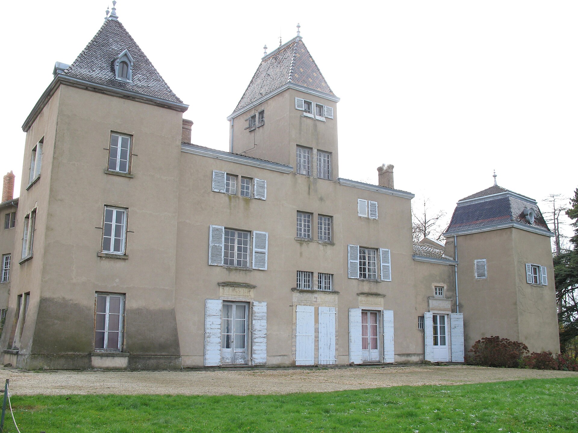
Château de Machy
Chasselay
Château de Machy Château de Machy is a 17th-century residence in Chasselay, in the Monts d'Or hills roughly 15 km from Lyon, in France's Rhône department. It isn't a museum-style castle with ticketed visits — since 1996 the building has been home to the professional theatre company La Première Seconde, which uses it as a working space for rehearsals, creation, and production, and has been gradually restoring it. How do you get there? Chasselay sits in the Monts d'Or, a hilly area just north of Lyon, easily reachable if you're already exploring the greater Lyon region. A car is the most practical option — the surrounding landscape is rural and undulating, dotted with vineyards, woods, and small villages typical of the Monts d'Or. The château itself stands among fields and rises on the edge of the commune, and the quiet countryside setting is part of the appeal, offering a clear contrast to the bustle of Lyon. What will you see? The château has no single architectural style — it's a cluster of buildings raised across different periods, without overall unity. The main building, set on level ground, is marked by a turret with a staircase in a design typical of the 17th century, while its original windows were later enlarged into bays. Inside, a grand living room survives with a French-style ceiling and painted door-top panels, a detail that hints at the ambitions of past owners. The site's history goes back to the Middle Ages, when Machy was a large agricultural estate. In 1556, J. Senneton bequeathed to his wife a cluster of houses known as the "castelet," believed to have stood on the same site as today's château. Construction of the château in its current form began in the 17th century. In 1778 the estate was bought by Jean-Antoine Morand for his son, Antoine Morand de Jouffrey, and the family kept the property until the third quarter of the 20th century. In 1978 it was acquired by the Office culturel de Cluny, and since 1996 it has been run by La Première Seconde. Because of its current use, access to the interior depends on the cultural calendar rather than fixed opening hours — this is a working venue, not a static exhibit. It's worth checking whether a performance, open rehearsal, or other event organized by La Première Seconde falls within your travel dates, since that's the best way to see the inside. Outside of such occasions, the château can still be admired from the outside while walking through the surrounding Monts d'Or countryside. When should you visit? The best time to plan a visit is around a scheduled theatre event or an open-heritage day — the château regularly takes part in events such as the Journées du Patrimoine (Heritage Days), when the buildings and their history are opened up to a wider public. Outside the cultural season, the Monts d'Or and the Chasselay area remain pleasant for walking year-round, with spring and autumn offering the most scenic version of the hilly landscape. Frequently Asked Questions Is Château de Machy open to visitors? It doesn't operate as a conventional tourist site with regular opening hours — it's the working home of the theatre company La Première Seconde. Interior access is mainly tied to cultural events, such as performances or Heritage Days. How far is Château de Machy from Lyon? The château is located in Chasselay, in the Monts d'Or, at an estimated distance of about 15 km from Lyon. What's notable about the château's architecture? The building has no unified style, being a group of structures from different eras. It stands out for its 17th-century-style turret with an internal staircase and for a living room featuring a French ceiling and painted door-top panels. Who manages the château today? Since 1978 it has been owned by the Office culturel de Cluny, and since 1996 it has been occupied and run artistically by the theatre company La Première Seconde.
-

Ancient theatre of Vienne
Vienne
The Ancient Theatre of Vienne stands in the town of Vienne, in the Isère department, and ranks among the best-preserved Gallo-Roman monuments in France. What is this site? The theatre was built in the 1st century AD, in stages, between 40 and 50 CE. With a capacity of roughly 11,000 to 14,000 spectators, it was the third-largest Roman theatre in Gaul, surpassed only by those of Autun and Mandeure. Together with the neighbouring Odeon, it forms an archaeological ensemble that is genuinely rare across the Roman world — only Lugdunum (present-day Lyon) and Valence pair a theatre with an odeon in the same city. As Vienne's importance as a Roman centre faded, the theatre was abandoned toward the end of the 3rd century. For centuries afterward it served as a stone quarry and dumping ground, and its remains were gradually buried under earth as terraced gardens took over the hillside. It took excavations carried out between 1908 and 1938 to dig the monument out from under several thousand cubic metres of soil and partially restore it to its current state. What will you see on site? Visitors can walk through the cavea (seating area), partly carved directly into the hillside, view the remains of the stage, and get a sense of how the theatre relates to the adjoining Odeon. The scale is the most striking part — even after nearly two thousand years, it's easy to picture how monumental this structure once was during Vienne's heyday as a Roman city. Since 1981, the theatre has come back to life every summer as the main stage of Jazz à Vienne, one of France's leading jazz festivals. Outside the festival, the venue also hosts other cultural events throughout the season. How do you get there? The theatre sits in the centre of Vienne, in Isère, an easy walk from the train station and the main municipal car parks. The town lies in the Auvergne-Rhône-Alpes region, about 30 km south of Lyon, making it a convenient day-trip destination. When should you visit? Opening hours shift with the season: from September through the end of October the theatre is open Tuesday to Sunday, 9:30 AM–12:45 PM and 1:30–6 PM, while during the winter months (November–March) visiting hours run from 1–5:30 PM. It is closed on Mondays. In summer, keep festival dates in mind, as some areas may have limited access during Jazz à Vienne. Frequently asked questions How much does admission cost? Full price is €3, with a reduced rate of €2 for students, visitors under 25 or over 65, and groups of 15 or more. Is the theatre still in use today? Yes. Every summer since 1981 it has hosted the Jazz à Vienne festival, and the stage is also used for other cultural events. How many people could it hold in Roman times? Estimates put its capacity at 11,000 to 14,000 spectators, making it the third-largest ancient theatre in all of Gaul. Can you visit the theatre together with the Odeon? Yes — the two structures form a single archaeological complex and are typically visited together, one of the few places in the world where a theatre and an odeon have survived side by side in the same city.
-
Immeuble de la Société théosophique
Paris
The Immeuble de la Société théosophique is an eclectic Art Nouveau building at 4 square Rapp, in Paris's 7th arrondissement, just a few minutes' walk from the Eiffel Tower and the Champ de Mars. Built between 1912 and 1915 by architect Louis Lefranc, it was purpose-designed as the headquarters of the French branch of the Theosophical Society, a role it still fills today. What does the façade look like? The façade mixes several styles at once. A corner turret and arched, wave-shaped window openings recall the "troubadour" revival style, while floral motifs and glazed bay windows are pure Art Nouveau. The ground floor is built in stone and the upper storeys in brick, giving the building its distinctive two-tone look. The richest feature is the decorative program itself: arabesques, mystical symbols, a diamond-patterned frieze dotted with five-pointed stars, and a swastika — an ancient Buddhist and Hindu symbol used here as part of Theosophical iconography, long before the sign was appropriated by other movements in the 20th century. What is inside the building? The building was designed for the Society's activities, so the interior is just as noteworthy as the façade. It holds an auditorium seating around 450 people, a domed entrance hall, an original staircase, a meeting room opening onto the courtyard, and a library with a reading room on the first floor. Since 25 April 1997, the façades, roofs, and these interior spaces have been listed as monuments historiques, and the building also carries the "Patrimoine du XXe siècle" label recognising significant 20th-century architecture. What is the history behind it? During the German occupation of Paris, the building was requisitioned and the Theosophical Society's archives were looted; part of the collection only made its way back to France from Russia in the 2000s. Today the building still houses the French section of the Theosophical Society, the Éditions Adyar publishing house, which produces the monthly magazine "Le Lotus Bleu," the Costa Rican embassy on the fourth floor, and a Masonic lodge — making it a rare address that combines spiritual, publishing, and diplomatic functions under one roof. How do you get there? Square Rapp is a small, quiet lane branching off avenue Rapp, right in the heart of the Gros Caillou neighbourhood. The closest access is via École Militaire metro station (line 8) or the Pont de l'Alma — Champ de Mars stop on RER C, both a few minutes' walk away. It's worth combining the visit with a stroll along avenue Rapp, where number 3 holds the famous 1900 Art Nouveau building by Jules Lavirotte — a separate structure often confused with the Theosophical Society's headquarters, but well worth seeing on the same walk. When is the best time to visit? The building is the working headquarters of an active society, not a museum, so the interior is not generally open to the public — but the façade can be admired at any time of year or day. Late afternoon gives the best light for photographing the architectural details, as the sun catches the eastern side of the square. The neighbourhood is especially pleasant in spring and early summer, when the small square in front of the building turns green and the surrounding streets come alive. Frequently asked questions Can you go inside? The building serves as the working headquarters of the Theosophical Society and is not a museum, so access to the interior is limited to events and meetings organised by the Society. The façade and its Art Nouveau details can, however, be freely viewed from the street. Who designed the building? The architect was Louis Lefranc, who built it between 1912 and 1915 specifically for the French section of the Theosophical Society. Is this the same building as the famous Lavirotte building? No. Number 3 on the same square holds a separate, slightly earlier (1899-1900) Art Nouveau building by Jules Lavirotte — the two buildings sit next to each other but have different architects and different histories. What does the swastika symbol on the façade mean? It is an ancient symbol used in Buddhist and Hindu tradition, present in the building's decoration as part of early-20th-century Theosophical symbolism, long before it acquired other, later associations. What else is worth seeing nearby? Square Rapp is within easy walking distance of the Eiffel Tower, the Champ de Mars, and the banks of the Seine, making it simple to combine a visit with the rest of a 7th-arrondissement itinerary.
-
Magletsch
Wartau
Magletsch is a former rock-hewn artillery fort above the village of Gretschins, in the municipality of Wartau, canton of St. Gallen. Known under the military codename A 6020 "Der Hammer," it spent decades as one of the Swiss Army's most closely guarded secrets — today part of its tunnels can be visited as a museum, and the surrounding cliffs draw climbers. Why was a fort built here? Construction began in 1940, at the height of Switzerland's mobilization against the threat of war. Magletsch formed the northeastern corner of the large Sargans defensive complex, one of the pillars of the so-called National Redoubt — a strategy of anchoring national defense in fortified mountain massifs. The garrison's job was to control the Rhine valley above the fortress and the approaches toward Wildhaus and Feldkirch, key corridors leading into the Alps. The fort held seven cannons, making it one of the largest and most powerful artillery works in the entire Redoubt. Building it required enormous resources — the project is estimated to have cost around 13 million Swiss francs of the time, a striking sum given the mountainous, underground setting. What is hidden underground? Inside Magletsch runs a tunnel network roughly 3.8 kilometers long. Because the local rock is permeable to water, every gallery had to be fully lined in concrete, or the installations would have suffered constant dampness. The complex was designed as a self-sufficient base for 381 soldiers, complete with its own bakery, laundry, and a 70-bed field hospital. Power came from three 200-horsepower Sulzer diesel engines, fed by two tanks holding 100,000 liters of fuel each. Drinking water was supplied from two reservoirs with a combined capacity of 1.6 million liters, while a powerful ventilation system kept air quality in the tunnels breathable despite the absence of natural airflow. What does the fort look like today? The 1995 Swiss Army reform ended Magletsch's active combat role. Since 2000, part of the fortress has been open to visitors as a fortification museum — the Artillerie-Fort Magletsch (AFOM) — run by a local association of military history enthusiasts. The visit covers both the technical backbone of the fort and the everyday conditions its garrison lived under. Above ground, the earthen cover that once camouflaged the fort has become a valuable habitat for rare flowers and plants, and a dedicated nature conservation plan now protects the site. The rock faces around Magletsch also serve as a climbing area (Klettergarten), popular with climbers from the Sarganserland region. How to get there and when to visit? Magletsch lies in the municipality of Wartau, in the Werdenberg region, close to the villages of Gretschins and Oberschan, in the canton of St. Gallen. The region sits at the eastern edge of Switzerland, near the borders with Liechtenstein and Austria, so the easiest approach is by car or by train to one of the Werdenberg towns, followed by local transport or a short walk. Museum visits typically run as guided tours, so it is worth checking the current schedule before setting out, since the fort is not open every day. The best time to visit is spring through autumn, when the surrounding hiking trails and climbing area are also accessible; in winter, snow can make reaching the entrances harder. Frequently asked questions What is Magletsch? It is a former underground Swiss Army artillery fort built in 1940, part of the Sargans fortress system, now partly open as a museum. Why was the fort nicknamed "Der Hammer"? The military codename reflected its firepower — with seven cannons, it ranked among the largest artillery works of the National Redoubt. Can visitors go inside the fort? Yes, since 2000 part of the complex has operated as a museum (AFOM), showing the tunnels, technical installations, and the living conditions of the former garrison. Are there other activities nearby? Yes, the cliffs around Magletsch form a well-known climbing area, and the hill covering the fort is now a protected habitat for rare plant life.
-
Château de La Corbière
Challex
Château de La Corbière is a ruined medieval fortress in the commune of Challex, in the Ain department of the Auvergne-Rhône-Alpes region. Built probably in the mid-12th century, the stronghold once stood on a rocky spur above the Rhône and for centuries was a key defensive point on the frontier between the lands of Geneva and Savoy. How to get there? The ruins lie about 1.5 km southeast of the village center of Challex, a small commune in the Pays de Gex, close to the Swiss border and not far from Geneva. The fortress sits on a sandstone promontory around 510 meters above sea level, overlooking the right bank of the Rhône. The easiest way to reach it is on foot, starting from the square in front of Challex town hall, where a marked walking trail leads out toward the river. What will you see? The stronghold was built in the 12th century and soon became property of the Counts of Geneva, forming a separate enclave of the Land of Gex within the surrounding barony. During the 13th century, the castle was fought over by the Counts of Geneva and the Lords of Faucigny, rival powers competing for influence in this part of the region. In 1287, the Count of Geneva bought the fortress outright, but within a few years, between 1291 and 1292, Savoyard troops besieged and captured it. The castle met its final end in 1321-1322: a siege that began on 17 November 1321 ended on 28 December with Savoy's forces taking the stronghold and destroying both the castle and the bridge it had been built to defend. Today only fragmentary foundations and wall sections remain, overgrown with scrub. A stone marker indicates the site of the former castle — without it, the ruins would be almost impossible to spot among the vegetation. The trail to the ruins The Château de La Corbière is reached via a local walking route called the "Parcours de la Corbière," roughly 4 km long and taking about an hour, with around 130 meters of elevation gain. The trail is moderately demanding, and the stretch near Ravoire can get slippery, especially after rain. Along the way, walkers pass the old fortified house known as "Confignon," the restored Champ Novaz fountain, and — beyond the castle ruins themselves — the remains of the old Challex mill. The walk can be extended along an easy riverside path all the way to the Chancy-Pougny dam. The whole route showcases the pastoral, agricultural character typical of the southern Pays de Gex, with views over the Rhône valley. When to visit? Since this is an unmanaged, open-air ruin with no visitor infrastructure, the best time to come is from spring through autumn, when the trail is dry and the slippery sections are easier to manage. Longer summer days make it easy to combine the walk to the castle with an extended route along the Rhône all the way to the dam, while autumn tends to bring fewer walkers and cooler conditions for the climb. Frequently asked questions What remains of Château de La Corbière today? Only fragmentary foundations and overgrown wall sections survive, marked by a stone indicator showing where the fortress once stood. Who destroyed the castle? Savoyard forces captured and ultimately destroyed it — first during a siege in 1291-1292, then definitively after a siege that ended on 28 December 1321. How do you reach the ruins? On foot via the "Parcours de la Corbière" trail, which starts at Challex town hall and covers about 4 km. Is the trail to the castle difficult? It's moderately challenging, with about 130 meters of elevation gain; the section near Ravoire can be slippery, especially after rain.
-
La Queuse de Gargantua
Borest
La Queuse de Gargantua is a small but striking standing stone right in the center of the village of Borest, in the Oise department of France, just south of the Halatte forest and not far from Senlis. It's the kind of roadside curiosity you could easily drive past without noticing — the stone now sits on the edge of a traffic roundabout, surrounded by an otherwise ordinary rural setting. What exactly is this stone? The menhir is a single sandstone monolith rising about 3.3 meters above ground. Its base is roughly 1.5 to over 2 meters wide, while its thickness is much slimmer — around 30 centimeters — giving it a distinctive flat, elongated silhouette rather than a bulky pillar shape. Local tradition also speaks of a substantial portion buried deep underground, though such claims are hard to confirm without excavation. The stone was officially classified as a French Historic Monument by decree on 10 July 1944, confirming its recognized archaeological value. Where does the name come from? "Queuse" is a Picard dialect word for an elongated whetstone — the kind of stone once used to sharpen scythes and sickles. That practical origin gave rise to a local legend: Gargantua, the giant figure of French folklore who appeared in regional tales long before Rabelais made him famous in literature, is said to have used this very stone to sharpen his knife or scythe. In folk tradition, Gargantua was an enormous, clumsy wanderer whose oversized body left traces across the landscape — boulders, hills, and depressions supposedly formed wherever he stumbled or dropped something. Is the menhir still in its original spot? Almost certainly not. Its current position at the edge of a roundabout in the village center strongly suggests it was moved from its original location at some point, likely during road construction or village layout changes. The area around Borest itself has a much older story than the monument alone — the site was inhabited as early as the Bronze Age and later used by Gallic populations, making it a genuinely interesting spot on the archaeological map of the Oise region. How do you get there? Borest sits just south of Senlis. The easiest approach is via the D330 road heading toward Mont-l'Évêque — the menhir stands right at the roundabout in the village center, so it's hard to miss if you're driving through on the main road. It fits naturally into a self-drive itinerary around the Hauts-de-France region, easily combined with a stop in Senlis or a walk through the Halatte forest. When should you visit, and what should you expect? The stone sits outdoors and can be visited year-round, free of charge, with no opening hours to worry about — it's simply part of the village streetscape. That said, since it stands right by a roundabout, visitors should be mindful of passing traffic when stopping to look or take photos. This isn't a destination for a long stay, but rather a quick, worthwhile pause on a longer trip through the region — a good photo opportunity paired with a memorable local legend. Frequently asked questions Is there an entrance fee for the menhir? No, the stone stands in a public space beside the road and can be viewed free of charge at any time. Is this the stone's original location? Probably not — its current position on the edge of a roundabout suggests it was relocated from its original site at some point in history. Where does the name "Queuse de Gargantua" come from? "Queuse" is a Picard word for an elongated sharpening stone, and Gargantua is the legendary giant of French folklore credited with using it to sharpen his blade. Can this stop be combined with other nearby attractions? Yes — Borest is close to both Senlis and the Halatte forest, making it easy to add a short stop at the menhir to a longer route through the Oise region.
-
Château (ruines)
Charny
Château (ruins) are the remains of a medieval stronghold perched on the edge of a plateau at the northern entrance to the village of Charny, in the Côte-d'Or department of Burgundy-Franche-Comté. The ruins rise above the local D108 road and form one of the most recognisable landmarks along this stretch of Burgundy. How do you get to the castle ruins in Charny? The ruins sit right on the D108 road, at the edge of Charny (postcode 21350), a short drive from Dijon. A car is the easiest way to reach the site — the road runs along the foot of the hill on which the fortress stands, so the walls and tower fragments are visible directly from the road. The grounds are private property, so visits are limited to viewing from the outside, from the road or its verge. There's no dedicated car park at the monument, but traffic on the D108 is light, making it easy to pull over briefly for a look and a photo. What will you actually see? What survives of the original structure are fragments of curtain walls and towers, heavily overgrown with vegetation. Some wall sections are more than 4 metres thick, and the largest towers once measured around 14 metres in diameter — a scale that gives a real sense of how imposing the complete fortress must have been. The remaining stonework traces a polygonal defensive perimeter that was originally flanked by eight round towers. Today it looks like a typical abandoned medieval ruin: blocks of stone emerging from dense undergrowth, the outline of curtain walls, and a clear sense of just how much ground the original stronghold covered, complete with a manor house, moat, and working outer courtyard. What's the history behind it? The stronghold at Charny was built in the 13th century and belonged for generations to the House of Bauffremont, one of the region's more prominent feudal families; as early as 1196, the lord of Charny was Étienne de Mont-Saint-Jean, pointing to the long feudal pedigree of this estate. A 1658 survey describes a castle with ten dressed-stone towers, three-metre-thick curtain walls topped with a covered defensive walkway, a large main building with two wings, moats, and an outer farmyard covering some six "journaux" of land. The fortress's decline came in 1614, when it was partially demolished on the orders of King Louis XIII, ending its military role for good. What survived has remained a fixture of the village landscape ever since, and on 27 May 1924 the ruins were officially listed as a historic monument (monument historique). When's the best time to visit? Since the site is viewed entirely from the outside, there's no ticket or booking needed and it can be visited year-round. Autumn and winter work best for photography, when bare trees reveal more of the wall and tower outlines. In spring and summer the vegetation thickens and partly hides the stonework, though the surrounding greenery gives the ruins a more picturesque setting. It pairs well with a longer trip through the Côte-d'Or, whether on the way to Dijon or while touring Burgundy's wine villages. Frequently asked questions Can you walk onto the ruins? No — the site is private property, and visits are limited to viewing from the D108 road and its immediate surroundings. Is there an entrance fee? No, the ruins are viewed for free from the public road, with no tickets and no booking required. How much time should you set aside? It's a quick stop — 15 to 20 minutes is enough to walk around the area, take photos, and read up on the castle's history. Are there other attractions nearby? Charny sits in the Côte-d'Or, close to Dijon, so a visit to the ruins pairs easily with a trip into the regional capital or a drive through the surrounding wine villages.
-
Château de Chazeuil
Chazeuil
Château de Chazeuil is a medieval fortress standing at the western edge of the village of Chazeuil, in the Côte-d'Or department, in the Bourgogne-Franche-Comté region of France. Built in the 14th century, it once guarded the approaches to the village, and today survives as one of the region's lesser-known but genuinely interesting examples of medieval military architecture. What is the history behind the château? The stronghold stands on the south side of the local road, now numbered RD 27, and originally belonged to the Chazeuil family, whose holdings were tied to the castellanies of Billy and Verneuil. The defensive layout followed a polygonal enclosure reinforced by eight round towers and surrounded by a moat, part of which has since been filled in. Over the following centuries the castle gradually fell into ruin, a decline that continued until the mid-20th century, when the current owner undertook a partial restoration, preserving the most valuable remaining structures. What can you see on site today? Several distinctive elements of the original fortification still stand, giving visitors a sense of the castle's original scale. The most recognizable is the so-called "salve tower," rising 22 metres and featuring a vaulted cellar, a raised ground floor, and two further storeys topped with a pavilion roof. Alongside it stand the main square tower, the east corner tower, and a semi-circular tower. The grounds also preserve an access staircase, a cistern, and a columbarium (dovecote) — features typical of self-sufficient medieval fortified residences. The château remains privately owned, so the best views of its walls and towers are from the RD 27, which runs directly alongside the building. How do you get to Chazeuil? Chazeuil sits in Côte-d'Or, in the heart of Burgundy, not far from the main routes linking Dijon to the south of the region. Travelling by car is by far the most practical option — the village is surrounded by the gentle farmland and shallow valleys typical of Burgundy, and the RD 27 road runs straight past the castle. The nearest larger towns with rail connections and car rental options are Dijon and Beaune, from where the final leg is best done by road. When is the best time to visit? The ruins are most rewarding to see in spring and autumn, when softer light and the surrounding fields and trees frame the stone walls particularly well. Summer can get warm, but it's also the easiest season to combine a stop in Chazeuil with visits to nearby Burgundy castles and vineyards. In winter, the bare landscape around the fortress gives it a starker, more dramatic character that architecture photographers may particularly appreciate. Frequently asked questions Is Château de Chazeuil a protected monument? Yes. The château was listed as a monument historique by a decree dated 16 December 1937, which protects its remaining structures as part of France's architectural heritage. Can you go inside the château? Château de Chazeuil is privately owned, so interior visits are not generally available. The building is best appreciated from the public road, the RD 27, which runs right along its south side. How old is the château? The original fortress dates to the 14th century, built as a stronghold for the Chazeuil family, whose lands were linked to the castellanies of Billy and Verneuil. What remains of the original structure? Surviving elements include the 22-metre "salve tower," the main square tower, the east corner tower, a semi-circular tower, and on the grounds a cistern and a columbarium.
-
Fortified house of Montamar
Saint-Yrieix-le-Déjalat
The fortified house of Montamar stands in ruins above a bend of the Corrèze river, in the commune of Saint-Yrieix-le-Déjalat in the Corrèze department of southwestern France. It is one of those quiet corners of the region where history and landscape meet without any crowds — the approach runs through woodland and open fields, and the reward is silence and a sweeping view over the valley. What will you see on site? The stronghold was built in the second half of the 13th century or the early 14th century by the lords of Saint-Yrieix, who wanted to control traffic on the road linking the Saint-Yrieix area to Bonnefond. The main structure — a rectangular building roughly 11.3 by 5.7 metres, with a beaten-earth floor rather than paving — sat on a levelled hilltop platform, flanked by two smaller wings to the north and south. A trapezoidal room measuring about 4.9 by 3.5 metres was added later, likely for domestic or military use. Lower down the eastern slope, the remains of a bread oven survive, a small trace of the everyday life of whoever garrisoned the place. Its defenses relied heavily on the terrain itself: a steep drop toward the river protected one side, while to the west the builders dug two crescent-shaped ditches reinforced with earthen ramparts and a palisade. This combination of natural and man-made defenses was typical of small feudal strongholds in medieval Limousin. The site did not stay in use for long. By the second half of the 14th century it had already been abandoned — a period when the Hundred Years' War was unsettling the region, and modest, lightly defended strongholds like Montamar simply could not hold against organized French and English armies. Archaeological surveys confirm a short, single phase of occupation rather than centuries of continuous use. Since 1987, the ruins have been listed as a French historic monument (monument historique, reference PA00099883), recognizing them as a record of local medieval defense. How to get there and when to visit? Montamar lies within the commune of Saint-Yrieix-le-Déjalat, close to Egletons, in the heart of Corrèze. The easiest approach is by car to the village, followed by a walk on foot — the site has no ticket office and no fixed opening hours, so it is worth checking with the Ventadour-Egletons-Monédières tourist office beforehand for current access conditions and any guided visits. Spring and summer are the best seasons: paths stay dry and the views over the Corrèze valley are at their clearest. Plan the walk for a calm part of the day, since there is no visitor infrastructure on site — no parking right by the ruins, no lighting — and the isolation is precisely what makes the place worthwhile. What else to combine with a visit? The area around Saint-Yrieix-le-Déjalat offers walking trails along the Corrèze river, with several viewpoints overlooking its meanders. For visitors interested in history and archaeology, Montamar pairs naturally with other medieval sites scattered across the wider Ventadour area. Frequently Asked Questions What is Montamar? It is the ruin of a medieval fortified house (maison-forte), built by local feudal lords around the turn of the 13th and 14th centuries to control a road through the Corrèze valley. Can visitors explore the ruins on their own? Yes, the site is reachable on foot, but it has no tourist infrastructure — no ticket booth, no on-site information panels, and no fixed hours. Contacting the local tourist office beforehand is recommended. Why was the stronghold abandoned so quickly? It lost its usefulness by the second half of the 14th century, during the Hundred Years' War, when small local fortifications could no longer offer real protection against organized armies. Is Montamar officially protected as a heritage site? Yes, since 4 November 1987 the ruins have been listed as a monument historique under reference PA00099883.
-
Logis de Maine-Moreau
Annepont
Logis de Maine-Moreau is a ruined 17th-century manor house in Annepont, a small village in the Charente-Maritime department of southwestern France. Only fragments of the original residence survive, but its stone staircase tower and entrance portal are striking enough to reward travelers who enjoy tracking down lesser-known rural heritage sites. What is this place? The manor was built in the first half of the 17th century as the seat of local nobility and the administrative center of a seigneurie, the estate from which surrounding land and tenants were managed under the Ancien Régime. What remains today is an octagonal staircase tower topped with a domed roof, together with a round-arched entrance portal that once carried five large stone vases along its crest. The main doorway is framed in Louis XIII style, with pilasters and a triangular pediment, and the dormer windows originally echoed the same decorative language of pediments and vases. In one corner of the garden, the foundations of a dovecote are still traceable — a detail that mattered in an era when the right to keep such a structure was reserved for the nobility. How do you get there? The ruins stand in the heart of Annepont, in the hamlet known as Le Bourg, postal code 17350. Annepont sits in the Vals de Saintonge area, roughly midway between Saintes and Saint-Jean-d'Angély, and is easily reached by car from the main roads connecting those two towns. Saintes, the nearest larger city, is only a short drive away, making it simple to combine a stop here with a day exploring the wider region. Public transport in this part of Charente-Maritime is limited, so a car is by far the most practical way to arrive. What will you see on site? Logis de Maine-Moreau is privately owned, so visits are limited to viewing the building from outside, from the road or the public approach to the property. The main draw is architectural detail: the carved portal, the geometry of the octagonal tower, and the surviving decoration on the dormers, all of which still hint at the layout of the original residence despite four centuries of weathering. The site has been protected as a historic monument since 22 August 1949, a recognition of its heritage value, though the building itself remains partly in ruins and has not been converted into a museum or visitor center. When should you visit? Since the visit consists mainly of viewing the facade and surrounding grounds outdoors, spring and autumn are the most rewarding seasons, when the light is softer and the surrounding fields look their best. Summer works well too, especially if the stop is folded into a wider tour of the Vals de Saintonge area, while winter's shorter days and more frequent rain can make it harder to appreciate the exterior detail. Frequently asked questions Can you go inside the building? No — Logis de Maine-Moreau is private property, so the visit is limited to viewing it from outside, with no access to the interior. How much time should I plan for? Viewing the portal, tower, and dovecote remains usually takes about 15–20 minutes — this is a stop along a regional route rather than a full day's destination on its own. Where does the name Maine-Moreau come from? The name comes from the historic landed estate to which the manor and its surrounding fields belonged, "maine" being an older French term for such a property. Are there other sights worth seeing near Annepont? Annepont lies within the Vals de Saintonge, an area known for rural Romanesque churches and historic manor houses, so it's worth pairing this stop with a look at similar sites in neighboring villages.
-
Villa of Lacou Dauzena
Brossac
Villa of Lacou Dauzena refers to the remains of a Gallo-Roman villa in the commune of Brossac, in the Charente department of the Nouvelle-Aquitaine region, France. The site is also known under the names La Coue d'Auzenat, Lacou-Dausena, or Lacou Dauzena, variants that trace back to a local Occitan place name. Where is it and how do you get there? The remains sit roughly 48 km south of Angoulême and about 1 km east of the centre of Brossac, on the way toward the neighbouring commune of Brie-sous-Chalais, at a spot known as La Coue d'Auzenat. The coordinates are 45.3311 N, 0.02833 W. The villa lies less than 500 metres northeast of the presumed course of an ancient road that is thought to have linked Saintes to Périgueux and Cahors, passing through Pons, Guimps, Condéon, Brossac, and Ribérac. That proximity to a major route likely explains why a Roman country residence was built at exactly this spot. What will you actually see on site? The site preserves the foundations and wall traces of a building from the Gallo-Roman period — the remains of a rural villa, meaning a combined residential and agricultural complex tied to farming the surrounding land. The remains are listed on the French register of historic monuments (monuments historiques) under reference PA00104265. It's worth setting expectations correctly: this isn't a reconstructed complex with visitor pavilions, but an open archaeological field. It appeals mainly to visitors interested in the region's history and in traces of the Roman presence in Charente, rather than to those hoping for dramatic standing ruins. Where does the name come from? The earliest known reference to the site appears in a document from 1278, cited by researcher Jacques Duguet, which uses the Occitan phrase "las Couz d'Ouvenac" — translated as "the walls of Ouvenac." Private archives from the 17th century mention it under other forms, such as "le village de Cosse, autrement dit de l'Auzenac" or "la prise du cou d'Auzenac." These historical name variants show that local memory of the Roman walls persisted for centuries before the site was formally identified and studied. Who looks after the site? Since 1980, the land has belonged to the Charente general council (now the departmental council), a status that gave the remains formal protection and a basis for further conservation work. When should you visit? Since this is an outdoor archaeological site, it's best visited in dry weather when the ground is easy to walk. Spring and early autumn tend to work well, avoiding summer heat while keeping vegetation from covering the wall traces too much. There's no visitor infrastructure on site — no ticket booth or fixed opening hours — so it makes most sense as a stop within a broader tour of Charente, for instance combined with a visit to Brossac itself. Frequently asked questions What is the Villa of Lacou Dauzena? It's the remains of a Gallo-Roman rural villa in the commune of Brossac, France, listed on the historic monuments register under reference PA00104265. How do you get to the site? It lies about 1 km east of Brossac, toward Brie-sous-Chalais, and roughly 48 km south of Angoulême. Is there a reconstructed villa or a museum on site? No — it's an open archaeological area showing foundation and wall remains, with no exhibition pavilions on the ground. Where does the name Lacou Dauzena come from? From an Occitan phrase recorded in a 1278 document as "las Couz d'Ouvenac," meaning "the walls of Ouvenac."
-
Château de Podensac
Podensac
Château de Podensac is a medieval fortress ruin in Podensac, a small town in the Gironde department on the Garonne river, in the Nouvelle-Aquitaine region of southwestern France. The castle stands on the river's left bank, though the Garonne once flowed much closer to its walls than it does today. What is the history behind the castle? The stronghold is first recorded in the mid-13th century. It suffered damage during the War of Guyenne (1294-1297) but was quickly rebuilt and remained militarily relevant, playing a part in the later War of Saint-Sardos in 1324. In the first half of the 14th century, Amanieu de Langoiran, of the d'Albret family, became lord of Podensac through his marriage to Mabille d'Escossans, heiress of both Langoiran and Podensac. Merging these two estates made the castle an important seat within the region's feudal landscape. What did the fortress originally look like? The stronghold was laid out on two levels: an upper, more heavily fortified section stood on the riverbank bluff and dominated the lower ground around it. What survives today is a single building whose window and door openings were altered in the 15th and 17th centuries, along with two partially preserved towers. The footprint of a third tower is still traceable on the ground, and historians believe a fourth likely once stood as well. In the 17th century the south-eastern defensive wall was torn down and replaced with a lower parapet, a common change once fortifications lost their military purpose. Moats 18 to 20 metres wide once surrounded the walls, fed either by the Garonne or by a spring, but they were filled in during the 19th century. What can visitors see today? The ruins of Château de Podensac form an irregular, polygonal outline best appreciated from the outside. The site is listed as a French historic monument, underlining its value as a surviving example of medieval defensive architecture in the Bordeaux area. Podensac is sometimes described as the "town of three castles" — besides the main fortress ruins, the area also includes Château de Chavat with its park and Château de Chantegrive, a well-known wine estate, making the town a worthwhile stop for anyone interested in both history and wine. How do you get to Podensac? Podensac sits in the Gironde department, roughly fifteen kilometres south of Bordeaux, in the heart of the Graves wine region. The easiest way to reach it is by car, since the town lies along the main roads connecting Bordeaux to the southern part of the department. No booking is needed to see the ruins, as the site is viewed from the outside while walking around the area. When is the best time to visit? Spring and early autumn are the most comfortable seasons, with mild weather around Bordeaux that suits walking and gives the surrounding vineyards their best look. Summers can bring the higher temperatures typical of southwestern France, so plan accordingly. Frequently asked questions Can you go inside the castle ruins? No — the ruins are privately held, and public access is limited to viewing the walls and towers from outside; entering the structure itself is not possible. Is there an entrance fee? No, viewing the ruins from the outside is free and can be done simply by walking through Podensac. What else is worth seeing in Podensac? Beyond the main castle ruins, visitors can see Château de Chavat and its park, the Château de Chantegrive vineyard, and the water tower designed by Le Corbusier in 1917. Is the castle connected to the local Graves wine region? The castle itself was a defensive stronghold rather than a wine estate, but Podensac lies right in the middle of the Graves appellation, so the surrounding area is dense with vineyards and tastings.
-
Ferme-grenier fortifiée de Coudouneu
Lançon-Provence
The fortified granary-farm of Coudouneu sits above Lançon-Provence, in the Bouches-du-Rhône department of Provence. This Iron Age storage settlement occupies a narrow rocky spur on the southern edge of the La Fare ridge, overlooking the Arc plain and the Étang de Berre. It has been listed as a monument historique since 1998 (reference PA13000026). What exactly is this site? Excavations revealed that Coudouneu was never a regular dwelling. There are no hearths and no living quarters anywhere on the site — the whole complex was built for one purpose: storing food. Archaeologists uncovered 154 dolia, large clay storage jars, some holding more than 300 litres, alongside other terracotta containers. The place functioned as a shared granary for the surrounding Gallic community, kept well ventilated to preserve stored goods over long periods. A stone perimeter wall enclosed the settlement, and the entrance was defended by a fortified gate topped with a wooden platform. Inside stood two elongated buildings, each split into a row of connected rooms with upper floors, separated by a narrow passage. Walls rose from stone foundations, topped with unbaked mud brick. When was it built, and how did it end? The granary was raised in the late 5th century BC. It stood for only a short time: in the early 4th century BC it was destroyed in a violent fire. That destruction, paradoxically, preserved the site remarkably well — charred grains of barley, millet and grapes survived intact to the present day. Among the finds, researchers point to what is reportedly the oldest known cultivated garlic clove in France, a detail local guides like to mention. How do you get there, and what else is nearby? The best way to visit Coudouneu is a walking loop of roughly 3.77 km, done in about ninety minutes of walking (allow closer to two hours with stops). Elevation gain is minimal and the route crosses open fields on marked paths — easy terrain, suitable for families. The most practical place to leave a car is along the D113 road near Lançon-de-Provence, on the La Fare side, which avoids crossing the busy dual carriageway on foot. Along the way, besides the granary's foundations and rock-cut steps, the trail passes a restored Chappe telegraph tower with its articulated signal arms — it operated between 1821 and 1855, relaying messages between Vitrolles and Salon. A memorial to Albert Testanier also stands on the route. In spring, especially May, the path is lined with poppies and Spanish lavender, and the ridge opens onto views over the Étang de Berre. When should you visit? Spring is the best season — wildflowers and mild temperatures make the walk far more pleasant. Provençal summers get hot, and most of the loop crosses open ground with little shade, so an early start and plenty of water are worth planning for. Frequently asked questions Is the site fenced off or staffed? No, it is an open archaeological site reached on foot; there is no permanent staff on location, though the local heritage group Amis du Vieux Lançon occasionally organises guided visits, for example during European Heritage Days. How is a ferme-grenier different from an ordinary Gallic settlement? The absence of hearths and living quarters shows that nobody lived here permanently — the buildings served only as a communal storage facility for the surrounding population. How long does a visit take? The full loop takes about two hours on foot, including time to look at the ruins, the telegraph tower, and the viewpoints along the way. Can you drive right up to the site? No, the road ends at parking along the D113; from there you continue on foot along a marked trail.
-
Ferme Rudel
Sainte-Eulalie
Ferme Rudel is a historic farmhouse in Sainte-Eulalie, a small mountain commune in the Ardèche department. The building stands in the hamlet of Rudel, high on the Ardèche plateau, and has been listed as a French historic monument since 1984. What is Ferme Rudel? Ferme Rudel is a representative example of a highland farm from Ardèche, a region known for stone rural architecture built to withstand harsh winters on an exposed plateau. Its façades and roof were registered as a "monument historique" by a decree dated 6 December 1984. The protection covers only the exterior walls and roofing, not the interior, and the property is recorded in the French heritage database under cadastral reference B 247. The farm remains private property, so it cannot be visited inside. Travelers can, however, see the building from the road running through the hamlet of Rudel — the architecture itself, typical of high-altitude Ardèche farms, is worth a brief stop while driving through the area. Where exactly is Sainte-Eulalie? Sainte-Eulalie is one of the highest communes in Ardèche, sitting on a plateau within the Monts d'Ardèche mountain range and inside the regional nature park of the same name. The area lies near the source of the Loire, one of France's longest rivers, and close to the well-known peak of Mont Gerbier-de-Jonc. The landscape here is made up of open pastures and moorland crossed by stone walls and scattered farmsteads, of which Ferme Rudel is one of the better-preserved examples. How do you get to Ferme Rudel? The farm sits in the hamlet of Rudel, in the commune of Sainte-Eulalie (postal code 07510), Ardèche. The easiest way to reach it is by car, following the local roads that connect Sainte-Eulalie to the surrounding villages across the plateau. It's worth combining a stop here with a longer route across the Ardèche plateau, adding the source of the Loire or a walk up Mont Gerbier-de-Jonc. When is the best time to visit? Because the plateau sits above 1,200 meters, winters here are long and often snowy, which can make roads harder to travel and limit visibility of the architecture. The most reliable period to visit is from May to September, when the weather is stable, roads are clear, and the surrounding pastures and valleys look their most scenic. What should you know before visiting? The farm is a private property — there is no visitor center, café, or organized tours on site. It suits travelers interested in rural architecture and regional history rather than those looking for a fully equipped tourist attraction. The best approach is to view it from outside as part of a relaxed drive through the area. Frequently asked questions Can you visit the inside of Ferme Rudel? No. It is private property, and the historic monument protection covers only the façades and roof, so the building is not open to visitors. Since when has Ferme Rudel been a protected monument? Its façades and roof were listed as a French historic monument by a decree dated 6 December 1984. How do you get to Ferme Rudel? The farm is located in the hamlet of Rudel, in the commune of Sainte-Eulalie (07510), Ardèche; the easiest way there is by car via the local plateau roads. What else is worth seeing nearby? The Sainte-Eulalie area is close to the source of the Loire and to Mont Gerbier-de-Jonc, both good additions to a visit to Ferme Rudel on the same route across the Ardèche plateau.
-
Chateau-Thierry Castle
Château-Thierry
Château-Thierry Castle is a medieval fortress standing on a hilltop above the town of Château-Thierry, in the Aisne department of the Hauts-de-France region. Its origins trace back to the 10th century, and today it survives as one of the largest fortified sites in northern France, open to visitors throughout the year. What is the history behind the castle? The earliest record of a keep on this hill comes from the chronicler Flodoard in the year 923. Over the 12th century the site expanded considerably: eleven towers were raised, and Count Thibaud II added a new defensive tower that later became known as the Tour Thibaut. In the following century, under Thibaud IV of Champagne, the surrounding ramparts were built — they still trace the outer boundary of the fortress today. The castle's status changed in 1285, when Philip the Fair married Joan of Navarre, hereditary Countess of Champagne. From that marriage onward the fortress passed into royal hands, remaining a crown property for generations. What can you see on site? The complex today includes sixteen towers, a massive keep, two main gates, a continuous line of ramparts, and a dry moat cut around the hill. One of the most striking features is the castle's kitchen block, monumental in scale and considered among the largest surviving examples in Europe — a hint at the size of the banquets held here during the 14th and 15th centuries. Beneath the castle lie extensive underground chambers. Some began as limestone quarries as early as the 11th century, and were later reinforced with stone arcades in the 12th and 13th centuries to serve as cellars and storerooms for the lord's household. Part of this underground network is now open to visitors as a walking route. On the esplanade in front of the castle, the Casteloscope visitor centre shows a short film on the site's history and features an augmented-reality installation recreating the atmosphere of the princely feasts once hosted within its walls. How do you get there? The castle sits on a hill right in the centre of Château-Thierry, within easy walking distance of the old town and main square. The town lies on the rail line connecting Paris with Reims and Épernay, making it accessible without a car — from the station it's roughly a fifteen-minute uphill walk to the castle hill. Drivers will find parking available near the base of the hill. When is the best time to visit? The castle is open every day of the year, with opening hours that shift by season: 9am–5pm from October to February, 9am–7pm from March to May, and 9am–8pm from June to September. Entry to the grounds is free, so there's no rush against a ticketed time slot. Spring and summer offer the most comfortable visiting conditions, since the longer opening hours make it easy to combine the castle with a walk through the old town below. Frequently asked questions Is there an entrance fee for the castle? No — access to the castle grounds and esplanade is free, with longer opening hours during the summer months. Who built Château-Thierry Castle? It grew in stages: a keep already stood here in the 10th century, and later Counts of Champagne — Thibaud II in the 12th century and Thibaud IV in the 13th — added the towers and ramparts. Can you visit underground passages at the castle? Yes, beneath the hill are former limestone quarries and cellars reinforced with 12th- and 13th-century arcades, accessible as part of a visit. How much time should you plan for a visit? Walking the ramparts, towers, and esplanade with the Casteloscope typically takes one to two hours.
-
Château de Tremblay-les-Villages
Tremblay-les-Villages
Château de Tremblay-les-Villages, also known as the castle of Tremblay-le-Vicomte, is a medieval fortified ruin standing at the edge of the small town of Tremblay-les-Villages in the Eure-et-Loir department, on the fringes of the Thimerais region. Rather than a postcard-perfect turreted château, this is a site where the raw earthworks and stone remnants of a border fortress are still legible on the ground — a rewarding stop for anyone interested in medieval military history. How do you get there? Tremblay-les-Villages sits northwest of Chartres, within easy reach of Nogent-le-Roi, Châteauneuf-en-Thymerais and Dreux. The castle remains are located right in the village, near the Place de l'Église, so once you reach the village centre you can continue on foot. Driving from Chartres is the most convenient option, taking roughly fifteen to twenty-five minutes; Dreux is another practical starting point. There is no direct rail link to the village, so public transport means checking regional bus timetables and allowing for a connection. What will you see? The site preserves a large motte castrale — an artificial mound that once carried the main tower — flanked by the remains of semi-circular barbicans. A massive keep stands to the north of the complex, and the whole ensemble is still ringed by ditches and earthen embankments that remain clearly readable in the landscape. In the 13th century, two additional defense towers were added to reinforce the enclosure, and their traces help visitors piece together how the fortification evolved over time. The first castle on this spot was probably built around 1070, most likely on the initiative of King Philip I, as part of a defensive line across the Thimerais meant to guard the road between Chartres and Dreux. Its position on the border repeatedly made it a target: between roughly 1075 and 1100 it suffered during Anglo-Norman raids led by Henry I, and after the English victory at Tinchebray in 1106 brought Normandy under English control, the area became the setting for prolonged frontier warfare. Another blow followed the Battle of Agincourt in 1415, when English forces under the Duke of Suffolk seized and razed castles across the region; in 1421 Tremblay was hit again during further Hundred Years' War campaigns. The fortress met its definitive end in June 1592, when a garrison from Verneuil pillaged and burned the estate — after that it was abandoned for good and became a convenient source of building stone for local residents rather than being rebuilt. Today the grounds are privately owned, and for several years the current heirs have opened the site to visitors on an occasional basis, mainly during the Journées du Patrimoine (European Heritage Days) in September. That is the best chance to walk through the fortification layout up close, rather than viewing it only from outside the boundary. When should you visit? September's Heritage Days are the standout opportunity, since access is sometimes opened up and on-site explanations are occasionally organised. Outside that window, it is worth checking current information with the local municipality, since availability depends entirely on the private owners. In terms of weather, the months from May to September make it easiest to appreciate the earthworks and ditches against a green backdrop. Frequently asked questions Can the castle be visited year-round? No — the site is privately owned, and regular access is mainly limited to the September Heritage Days. Access is otherwise restricted. What actually survives from the original castle? The earthen motte, traces of the semi-circular barbicans, a massive keep to the north, two defense towers added in the 13th century, and the surrounding ditches and embankments are all still visible. Why was the castle destroyed? The fortress repeatedly fell victim to border conflicts — Anglo-Norman raids and Hundred Years' War campaigns — with the final blow coming from a fire set by a garrison from Verneuil in 1592. Are there other attractions nearby worth combining with a visit? Tremblay-les-Villages is close to Chartres and its famous cathedral, as well as the towns of Nogent-le-Roi and Châteauneuf-en-Thymerais, making it easy to build a longer day trip around the Thimerais region.
-
Château de Forbin (ruines)
Solliès-Ville
Château de Forbin is a set of romantic medieval castle ruins on Montjoie hill in Solliès-Ville, a small village in the Var department of Provence. Only fragments of the original stronghold remain, but the site still draws visitors — less for the architecture than for its history and the view it commands. What is the history behind the ruins? The fortress is tied to the Forbin family, one of Provence's most prominent noble houses. In 1468, Palamède de Forbin bought the fief of Solliès from Jean de Beauvau for 13,000 florins, formally taking possession on 20 April 1469. The Forbin family held the fief for more than 270 years, until the death of its last descendant in 1743. The castle itself did not survive intact. In 1578, during a peasant uprising, it was looted and destroyed — an event that permanently shaped the ruined state visitors see today. Who saved the ruins from oblivion? The site's fate is closely linked to Jean Aicard, a French writer and poet who became mayor of Solliès-Ville in 1919. Aicard pushed for the Forbin castle ruins to be listed as a historic monument, which was formally granted by decree on 22 June 1920. Aicard himself wrote the play "Forbin de Solliès ou le Testament du roi René," staged among the ruins in August 1920 by the Comédie-Française, France's national theatre. Today the ruins belong to the commune of Solliès-Ville. What will you actually see on site? The ruins themselves are modest — surviving wall fragments and the outline of the original structure let you picture the scale of the former stronghold, but this isn't a restored castle with a guided route through furnished rooms. The real draw is the Montjoie esplanade, which opens onto a sweeping panorama of the Gapeau valley. On a clear day you can spot the Maures massif and its highest point, Notre-Dame-des-Anges (780 m). How do you get there, and when's the best time to visit? Solliès-Ville sits in the central Var department, close to Toulon and the Gapeau valley. Montjoie hill, where the ruins stand, rises above the village, so reaching them means a short uphill walk — comfortable shoes matter more here than in a typical town centre. Given the ruins' condition and limited infrastructure, it's worth checking current access conditions with the local Vallée du Gapeau tourist office before you go. Spring and autumn are the best seasons, when Provence's mild temperatures make the climb comfortable and the views from the esplanade are at their clearest. In summer, the exposed hilltop and strong midday sun can make longer stays uncomfortable. Frequently asked questions Can you go inside the castle? No — only wall fragments remain. This isn't a roofed building with an interior tour; it's more of a viewpoint dotted with historic remains. How long does a visit take? Not long, usually 20–40 minutes including the walk up the hill and time to take in the view over the Gapeau valley. Is entry free? The ruins are commune-owned open public ground, but it's worth confirming current access conditions with the tourist office before your visit. What else is worth seeing nearby? The village of Solliès-Ville itself, with its narrow lanes, and nearby Solliès-Pont, where the restored Forbin family château now houses the town hall — an interesting contrast between the fates of two buildings owned by the same family.
-
Restes des arènes gallo-romaines
Limoges
The remains of the Gallo-Roman arena sit right in the center of Limoges, protected as a listed historic monument and located on Place des Carmes, next to the Jardin d'Orsay. What is this site? Back in the 2nd century AD — possibly even as early as Trajan's reign — the Roman town of Augustoritum, the ancestor of modern Limoges, built a huge amphitheatre on a rise above the Vienne river. The elliptical structure measured roughly 137 by 116 metres, with an arena floor of 64 by 48 metres. That makes it one of the largest amphitheatres anywhere in Roman Gaul, with an estimated capacity of 20,000 to 25,000 spectators — more people than the town itself likely held at the time. It stood at the junction of two major Roman roads: the Via Agrippa linking Lyon to Saintes, and another route running toward Poitiers. What happened to it after Rome fell? Once the Western Roman Empire collapsed, the amphitheatre lost its purpose and quickly became a source of ready-cut stone. Emperor Louis the Pious granted monks from the Saint-Martial abbey permission to strip material from the ruins to build their own monastery. The abandoned arches later became a hideout for bandits and beggars, and in the 16th century more sections of wall were torn down. The final blow came in 1718, when intendant Charles Boucher d'Orsay levelled and buried the site while laying out a new town garden — today's Jardin d'Orsay — covering the ruins under several metres of earth. What can you actually see today? Most of the amphitheatre now lies hidden beneath the Jardin d'Orsay and Place des Carmes. Restoration work in 1966 uncovered some surviving walls, and the site was granted historic-monument status in 1946 and again in 1968. The sections exposed during that 1966 work were deliberately reburied in 1998 to protect them from erosion and moisture — a standard conservation approach for ruins this fragile. One block of masonry still breaks the surface of the ground, the only fragment visitors can see without excavation. Even though the arena itself stays out of sight, the surrounding garden and the historic streets of Place des Carmes still make for a pleasant stop while exploring central Limoges. How do you get there? The site sits in the heart of Limoges, within easy walking distance of the Limoges-Bénédictins train station and the old town. Walking is the simplest way in, following the streets that connect the city-centre shopping area with the Carmes district. Several other traces of Roman Augustoritum lie nearby, so it's easy to turn the visit into a short walk through the ancient town's footprint. When should you visit? Since the main draw is an open public square and garden, there's no bad time to stop by — it's accessible year-round, day or night. Spring and summer make for a more comfortable stroll through the Jardin d'Orsay, and the information panels near Place des Carmes help visitors picture the scale of the original structure. Frequently asked questions Can you actually see the amphitheatre ruins? Only partially. Most of the structure is buried for protection, but one block of masonry still emerges from the ground at Place des Carmes. How big was the Limoges amphitheatre? It measured about 137 by 116 metres and could hold an estimated 20,000 to 25,000 spectators, making it one of the largest in Roman Gaul. Why were the ruins buried? The site was first buried in 1718 when the town garden was created, and remains uncovered in 1966 were reburied in 1998 to shield them from moisture and erosion. Is there an entrance fee? No — it's a public square and municipal garden, open and free to visit year-round.
-
Ruines du château de Gannes
L'Hôme-Chamondot
The ruins of Château de Gannes stand in the commune of L'Hôme-Chamondot, in the Orne department of Normandy. The remains lie roughly a kilometre northeast of the village centre, in the valley of the Jambée river near the La Motte farm, surrounded by a large pond that once formed part of the castle's natural defences. How do you get there? The ruins sit along a signposted walking trail that starts at the town hall car park in L'Hôme-Chamondot. The route passes through the village, goes by the church, then turns onto the second road on the right toward "La basse Métairie". From there a gravel farm track crosses open fields and loops around a small hedge-lined pond before joining the D617 road. After following the D617 for a short stretch, the path turns off again onto a sandy track that winds through heather and ferns straight to the castle ruins. Near the starting point, the Brasserie du Perche offers a convenient stop for a bite before or after the walk. What will you see? What survives of the fortress is mainly the base of a square keep measuring roughly 15 by 20 metres, raised on an artificial feudal mound (motte). Its walls, built from coarse flint rubble more than two metres thick, were reinforced at the corners with cut sandstone. The best-preserved section stands on the east side, where the masonry still rises to about ten metres — tall enough to give a real sense of the original structure's scale. The marshy valley and pond that surround the site explain why the castle was once considered nearly impregnable. Château de Gannes was destroyed in 1428, during the Hundred Years' War, by English forces commanded by Thomas Montagu, Earl of Salisbury. Despite its strong defensive position on a mound protected by isolating marshland, English companies managed to storm and burn the fortress. Salisbury himself was killed shortly afterward at the siege of Orléans. The episode gave rise to a local legend of the White Lady: the castle lord's daughter, desperately in love with an English captain, is said to have betrayed her own people by opening the postern gate to the enemy. The ruins were officially listed as a monument historique by decree on 11 October 1933, recognising their value as surviving evidence of medieval defensive architecture in the Perche region. When should you visit? The site is best visited during drier seasons — spring and summer — when the sandy and gravel sections of the trail are easiest to walk, since parts of the path can turn muddy after rain. Autumn brings its own appeal, as the heather and fern moorland around the ruins takes on rich seasonal colours. This is a destination for travellers looking for a quiet countryside walk paired with local history rather than a fully equipped tourist attraction, so sturdy footwear is recommended. Frequently Asked Questions Are the ruins of Château de Gannes open to the public? Yes, the ruins lie along a public walking trail and can be visited freely, though there is no on-site tourist infrastructure — this is a rural historical site rather than a managed attraction. How long is the walk to the ruins? The loop from the town hall car park to the ruins and back crosses fields, skirts a pond, and winds through heather moorland — a gentle, few-kilometre walk suitable for most visitors. Why was the castle destroyed? English forces under Thomas Montagu, Earl of Salisbury, burned the fortress in 1428 during the Hundred Years' War, despite its strong natural defences provided by the surrounding marshland. What exactly remains of the castle today? The base of a square keep about 15 by 20 metres survives, with walls of flint rubble reinforced by sandstone at the corners; the tallest surviving section, on the east side, reaches roughly ten metres.
-
Château de Poutrincourt
Lanchères
Château de Poutrincourt is a set of medieval castle ruins in Lanchères, a small commune in the Somme department, just a few kilometers from the Baie de Somme. The site carries an outsized piece of history — it was from here, in 1605, that Jean de Poutrincourt set off to help found Port-Royal in Acadia, the first permanent French settlement in North America, in what is now Nova Scotia, Canada. How do you get there? Lanchères sits in western Somme, along the coastal strip between Le Crotoy and Cayeux-sur-Mer. A car is the easiest way to reach it — Abbeville and Le Crotoy are the nearest larger towns, both a short drive away on local roads. The ruins themselves stand in the hamlet of Poutrincourt, administratively part of Lanchères, surrounded by the hedgerow farmland typical of the area. What will you see? The castle was built in the 15th or 16th century as the seat of the Biencourt family, who held the estate from 1403 until the French Revolution. Today only part of one long facade and its two side walls survive — the entire front wall is gone. The walls, roughly 0.75 meters thick, were built in a checkerboard pattern of flint and brick reinforced with tuf, a construction technique typical of defensive buildings in Picardy. Two themed gardens have been laid out around the ruins: a medieval garden with around 250 plant species that would have been cultivated when the castle was built, and a Garden of Genesis featuring more than 80 plant varieties mentioned in the Bible. A small on-site museum displays a collection of agricultural tools, illustrating rural life in Picardy in past centuries. The site's real significance goes beyond its walls. Jean de Poutrincourt, brother of Jacques de Biencourt, the castle's owner at the time, left from here to become one of the founders of Port-Royal — making this modest corner of Picardy the starting point of a landmark chapter in French colonial expansion in the Americas. When should you visit? The ruins, gardens, and museum are open seasonally, from May 1 to September 30. Guided tours run daily at 3:00 pm, except on Tuesdays. Summer is the best time to visit, when the gardens are in full bloom and conditions around the Baie de Somme are at their most pleasant. Good to know The site was listed as a French historical monument by decree on March 18, 1980, recognizing its value both as an example of regional defensive architecture and as a landmark in the story of French colonization. Frequently asked questions Can you visit the ruins on your own? No — tours are guided, held daily at 3:00 pm (except Tuesdays), during the season running from May to the end of September. What is the castle's connection to Canada? Jean de Poutrincourt set out from here and helped establish Port-Royal in Acadia in 1604–1605, the first permanent French settlement in North America. Is there more to see than just the ruins? Yes — the grounds include two themed gardens (a medieval garden and the biblical Garden of Genesis) and a small museum displaying historic farming tools. How far is the castle from the Baie de Somme? Lanchères lies just a few kilometers from the bay, on the coastal strip between Le Crotoy and Cayeux-sur-Mer, making it easy to combine with a trip to the coast.
-
Château d'Oissy
Oissy
Château d'Oissy stands in the small village of Oissy, in the Somme department west of Amiens, France. Built in the 18th century for the Trudaine family, it is today less a castle to walk through than a historic site to walk around — a 1946 fire destroyed most of the building, leaving the gatehouse, park, and ground-floor walls as the protected remnants of a once-substantial country estate. How do you get to Oissy? Oissy sits in Picardy, in the Hauts-de-France region, a short drive from Amiens, which has the nearest rail and road links to Paris and the Channel coast. There's no train station in the village itself, so a car is the practical option — the surrounding countryside is classic rural Somme, dotted with farms and small hamlets rather than tourist facilities. Given how small Oissy is, it works best as a stop on a wider tour of the department's historic houses and villages rather than a standalone destination. What's left to see? The château was raised in the 18th century on the initiative of François II Trudaine, built on a rectangular plan in brick and stone over a sandstone base, with one floor above a raised ground level and a tall, French-style roof typical of the period. The 1946 fire left only the ground-floor walls of that building standing — the upper structure is gone, and what you see today is essentially a footprint rather than a facade. The wider estate fared better. Surviving elements include the park and garden, the perimeter fencing, an imposing entrance gate, two pavilions, and a canal that once ran through the grounds. This whole ensemble — gate, ruined château walls, pavilions, park, garden, and canal — was listed as a historic monument by decree on 11 June 2001. It's the layout of the estate as a whole, more than any single building, that earns Oissy its heritage status today. The property remains privately owned, so there is no public access to the grounds or the ruins. Visitors should expect to view the site from outside the fence line, along the road — the entrance gate and the outline of the park are the main things you'll actually see. A brief history: from the d'Ailly family to the Trudaines The estate's documented history goes back to 1609, when Antoinette d'Ailly, wife of Henry de Fay, sold it to Antoine Trudaine, a treasurer of France for the Amiens region. The Trudaine family held the property across several generations until the French Revolution; it was François II Trudaine, a later member of the family, who built the château in its 18th-century form. In 1795, during the revolutionary seizure of aristocratic property, the estate was sold off as a bien national — national property — closing out close to two centuries of Trudaine ownership. When should you visit? Because there's no interior to tour, timing matters less here than at châteaux open to the public. Spring and early autumn tend to give the best light for photographing the gate and the park's greenery, and roads in this part of the Somme are quieter than during the summer holiday season. Frequently asked questions Can you go inside Château d'Oissy? No. The property is privately owned, and the château building itself burned down in 1946. You can view the estate from outside, mainly the entrance gate and the park. Why is it a listed historic monument if the château burned down? The 2001 listing protects the whole surviving ensemble — the gate, the remaining walls, the pavilions, the park, garden, and canal — not just the château building. Who built Château d'Oissy? François II Trudaine built it in the 18th century, continuing a family estate that had belonged to the Trudaines since 1609. How do you get to Oissy? By car. The village is in the Somme department near Amiens and has no train station of its own.
-
Château d'Happlaincourt
Villers-Carbonnel
Château d'Happlaincourt is a set of medieval fortress ruins in Villers-Carbonnel, a small village in the Somme department of northern France. What remains of the castle stands on the bank of the Canal du Nord, on the site of a fortified residence first built by the Happlaincourt family in the 13th century. How old is this castle, and who built it? The manor is first documented in the 13th century, when it was laid out as a rectangular fortified compound ringed by water-filled ditches — a defensive design well suited to the flat Somme countryside, where moats stood in for the hills and cliffs used elsewhere in France. Ownership passed over the centuries from the Happlaincourt family to the house of Étampes, and later to the Jallu family. Why does this ruin matter beyond local history? The château's story reaches well past Villers-Carbonnel. In 1415 the lord of Happlaincourt was killed at the Battle of Agincourt, and in the decades that followed his estate became a contested prize between factions loyal to the French crown and to Burgundy — a period of civil conflict that weakened France in the later stages of the Hundred Years' War. More than 150 years later, in June 1576, local nobles gathered at the château at the urging of Jacques d'Humières to draft a manifesto calling on regional princes and clergy to restore Catholic worship and obedience to the king, a document tied to the wider religious wars unsettling France at the time. What is left standing today? As late as the 19th century the north-east and north-west wings still stood, joined by a central gatehouse. That gatehouse, though it has lost its upper section and shows visible damage, remains the most recognisable piece of the site today. Most of the surrounding walls and corner towers were destroyed during the First World War, when the front line cut directly through this stretch of the Somme. Visitors can now see wall fragments, the bases of former towers, and the gatehouse itself, framed by the remains of the old moat. When is the best time to visit, and how do you get there? Villers-Carbonnel sits in a quiet, rural corner of the Somme, close to the route running alongside the Canal du Nord — a region known above all for its First World War memorials and battlefields. Seeing the ruins themselves doesn't take long, so they pair well with a stop at nearby WWI heritage sites. Spring and summer are the easiest seasons to visit, with longer daylight hours and easier footing around the site. This is not a restored, ticketed attraction — it's an authentic, partly overgrown ruin, so come prepared for uneven ground. Why is it a protected historic monument? Despite the losses of the 20th century, the remains of Château d'Happlaincourt were listed as a monument historique by decree on 24 April 1926. The listing recognises both the surviving evidence of the region's defensive architecture and the château's role in episodes of national significance, from medieval feudal disputes to the religious politics of the 16th century. Frequently asked questions Can visitors go inside the ruins? The surviving gatehouse and wall sections can be viewed from the outside, but this is a genuine ruin rather than a fully equipped tourist site, so caution is needed when walking around it. Is the château connected to the First World War? Yes — most of the original 13th-century structure was destroyed during fighting in this part of the Somme during the First World War. What part of the original building survives best? The central gatehouse is the best-preserved element, even without its upper section, along with wall fragments and tower bases around the former courtyard. What makes this château stand out among other Somme ruins? Its layered political history does — from the death of its lord at Agincourt in 1415 to the religious manifesto drafted within its walls in 1576.
-
Château de Boves
Boves
Boves Castle (Château de Boves) sits in the village of Boves, roughly 8 km southeast of Amiens, in the Somme department of the Hauts-de-France region. What actually survives on site? Two things remain of the once-large complex: an artificial castle mound (motte castrale) and two wall sections of a 14th-century tower, the last major rebuilding phase the castle went through. The mound itself was raised, most likely in the 10th century, entirely by hand rather than shaped from a natural hill, and was enlarged more than once over the following centuries to carry timber and stone defensive structures. How long was the site occupied? Continuously from the 9th century through the 17th, Boves served as a major aristocratic residence and a genuine center of regional power in Picardy. A priory dedicated to Saint-Ausbert, affiliated with the abbey of Cluny, operated inside the castle courtyard during the 12th century. Ferry I of Vaudémont rebuilt the fortress in the 14th century — the tower walls still standing today date from that campaign. The castle was dismantled in 1595, and its stone was later carted off and reused, effectively turning the site into a quarry. Why does this ruin matter historically? In July 1185, the Treaty of Boves was signed here between King Philip II Augustus of France and Philip of Alsace, Count of Flanders, settling a dispute over territory and influence in northern France. It's one of the more consequential medieval agreements sealed on French soil, which is why Boves comes up in general histories of the period and not only in local ones. What have archaeologists found? Excavations carried out on the motte between 1996 and 2019 traced an uninterrupted, layered sequence of construction phases running from the 9th to the 17th century. The dig is ongoing, and the site is still treated as an active archaeological zone rather than a finished monument. How do you get there, and what should you know before visiting? Boves is a short drive southeast of central Amiens, easily reached by car. Entry to the ruins is free, but this is a working excavation site: stick to the marked paths, don't climb on the old walls, and watch your footing — loose stones and uneven ground are a real hazard. Guided tours led by the archaeologists working on the dig are organized periodically, including through Amiens Tourisme, and there's also a roughly 8 km archaeological walking trail rated medium difficulty, for which booking ahead is recommended. When's the best time to go? The ruins are open year-round, but the ground is uneven and there's no shelter, so drier weather — spring or summer — makes for easier, safer footing. If you want to join a guided visit, check the schedule in advance, since these run on set dates rather than continuously. Frequently Asked Questions Is it free to visit Boves Castle? Yes, access to the ruins is free, though caution is required since excavation work is still active on site. How far is Boves from Amiens? About 8 km southeast of central Amiens — a short drive. What happened at Boves Castle in 1185? King Philip II Augustus of France and Philip of Alsace, Count of Flanders, signed a peace treaty there. Can you visit with a guide? Yes — guided tours run by the site's archaeologists are organized, and a dedicated archaeological walking trail is also available.
-
Castle of Eaucourt-sur-Somme
Eaucourt-sur-Somme
The Castle of Eaucourt-sur-Somme is a ruined medieval stronghold on the banks of the Somme river, in the small village of Eaucourt-sur-Somme in the Hauts-de-France region, within the historic county of Ponthieu. How old is the castle? The first structure went up at the turn of the 12th and 13th centuries as a maison forte — a fortified residence built on the river's left bank, on low-lying ground just outside the village. The marshy setting was deliberate: water surrounding the foundations formed a natural defensive barrier, and the site's position by a river crossing let its lords control traffic and trade moving along the Somme. What happened to it during the Hundred Years' War? The castle's roughest chapter came during the Hundred Years' War. In June 1421 it fell to combined English and Burgundian forces, only to be retaken soon after by supporters of the French Dauphin under Jacques d'Harcourt. In response, Philip the Good, Duke of Burgundy, had the abandoned castle burned. Jean d'Eaucourt rebuilt it in 1436, but peace didn't last — in 1440 mercenary captain Pierre Renaud de Vignolles plundered the stronghold. A further blow landed in the second half of the 16th century, when fighting tied to the Catholic League during the Wars of Religion left part of the castle dismantled. Why is it a ruin today? The estate stayed in the hands of noble families for a while longer, but from the 18th century onward it steadily lost importance and was gradually abandoned. That slow decline left the castle in the ruined state it's in today. In 1926 it was listed as a historic monument, kicking off a long process of protecting what remained. A turning point came in 2016, when the ruins were purchased by the municipality of Eaucourt-sur-Somme; an archaeological research programme has also been running on site since 2015, gradually uncovering the original layout of the buildings. What is there to see on site? The grounds now blend genuine medieval ruins with living history. Restoration campaigns have been underway for several decades, and the site now hosts medieval-themed events, craft workshops, and demonstrations for schools and groups. During the summer Médiévales d'Eaucourt festival, running from mid-July to mid-August, visitors can try on armour, have a go at crossbow shooting, learn stonecutting and leatherworking, and find out how medicinal plants were used in the Middle Ages. How do you get there, and when's the best time to visit? The castle sits at 300 Rue du Pont, right in Eaucourt-sur-Somme, close to the Baie de Somme — a region known for its bird reserves and cycling routes. The best time to come is during the summer historical festivals, when the site is at its liveliest, though the ruins and the surrounding Somme valley landscape are worth a visit at any time of year. Frequently asked questions How old is the Castle of Eaucourt-sur-Somme? The original structure dates to the turn of the 12th and 13th centuries as a fortified residence, and later rebuilding — notably in 1436 — shaped the layout known from historical sources. Can visitors go inside? Yes, the ruins are open to visitors, and in summer the site hosts festivals and workshops centred on medieval crafts and life. Why is the castle in ruins? Damage from the Hundred Years' War, partial demolition during the 16th-century Wars of Religion, and gradual abandonment from the 18th century onward left it in its current state. Who manages the castle today? Since 2016 the ruins have belonged to the municipality of Eaucourt-sur-Somme, which oversees conservation work and supports the ongoing archaeological research on site.
Earn badges for the places you visit
Download NextOnTrip, discover new places and check off your trails.